• Home
  • About
  • Alabama Chapter Trail of Tears Association
  • National Trail of Tears Association
  • Local History

New Seneca Turkey's Town

~ Uncovering the History of Turkeystown, a Cherokee Village/Town in Northeast Alabama

New Seneca Turkey's Town

Monthly Archives: February 2025

Uncovering the History of Turkeytown, Location, By Chief Pathkiller’s family

24 Monday Feb 2025

Posted by Jeffrey Sauls in Local History

≈ Leave a comment

Tags

cherokee-indians, native-american, New Seneca, northeast-alabama-history, trail-of-tears, turkeytown

We have discovered that the actual location of Turkey’s Town is in Etowah County, Alabama. It is not one mile south of Centre, Alabama. This was revealed in the last post. Chief Charles R. Hicks and Reverend Daniel Butrick have given that information. How did the location in Centre, Alabama, come to be, and why is there conflicting information? Where did Chief Pathkiller live and where was his fort?

In this post, Chief Pathkiller and and his family explain where they lived. In the next post, we will examine the Centre, Alabama location. Hopefully, you will see the confusion come to an understanding.

The past Historians must not have had access to the family’s disputes. These disputes were between Pathkiller’s family over ownership of improvements. We learn a lot about Pathkiller’s family and uncover the history of Turkeytown.

The treaty of 1830 established the “Indian Removal Act.” The 1835 treaty resulted in the Trail of Tears, the forced removal of the Cherokee people. The Cherokee people filed claims for payment with the United States for what they left behind. They are referred to as Validation/Spoliation Claims. The people would be paid for houses, furniture, crops, and other miscellaneous items. This leads to misunderstandings within families. Chief Pathkiller’s grandchildren got into one of these disputes. Fortunately, this provides us with information on the location of Turkey’s Town. Bonus info is Pathkiller’s family history.

Pathkiller’s Grandchildren Dispute 1837

12 of September 1837 Personally, comes before me James Lasley being duly sworn that he does live in the neighborhood of the contested improvements. . . The grandfather of this claimant Anna Pathkiller being the person who made the first improvement and kept it and held it legally as his according to the Law and usage til about the year 1815 he made his children stay there to mine his stock and use it as a stock keeping place   Tis true Dragging Canoe one of the old mans children did stay on the place for the purpose of keeping the stock as above and for no other purpose and under the direction and consent of the old man this grandfather as above nor did the old man give it or convey it to any one but his wife Peggy   he died and left this in possession of the said place . . .this Peggy was the Legally possessed of it     Before Peggy died a short time she made a will and left it Nelly her daughter who is the mother of Anna the present claimant and this Nelly told this despondent that she had given this said improvement to this same claimant Anna Pathkiller1

Above is a statement from an affidavit in part of James Lasley to Wilson Lumpkin. Lumpkin is the US Commissioner to the Cherokee Indians (1836-1837). He became Georgia’s Governor 1837-1841. He recorded several of the affidavits. The affidavit concerns the dispute of ownership of improvements on Chief Pathkiller and Peggy’s estate in 1837. This estate is today’s Alford’s Bend, Etowah County, Alabama.

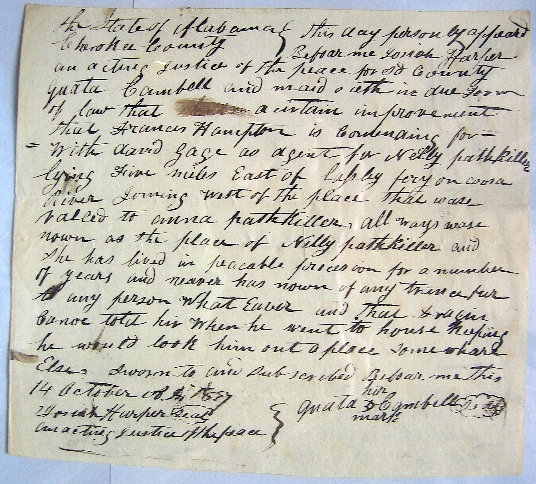
Several affidavits were collected. They aimed to settle a dispute between Anna Pathkiller Hampton and Dragging Canoe’s son, daughter, and widow. The disagreement was over the improvements on the East side of the Coosa River at Peggy Pathkiller’s ferry.

Affidavit taken by Josiah Harper Justice of the Peace Cherokee County, Alabama 14 Oct 1837. Quata Campbell is Chief Pathkiller and Peggy’s daughter married to George Campbell.2

Dragging Canoe (not the Chickamauga war Chief) is the son of Pathkiller and Peggy. Sky-ah-too-ka is Dragging Canoe’s son. Dragging Canoe’s wife is Watty, and his daughter is Martha. David Gage, their representative, argues for them about ownership of the improvements. These improvements are on the “East side of the Coosa River five miles below Lasley’s ferry.”  Lasley’s ferry is the today’s Croft ferry, Etowah County, Alabama. (James Lasley is a post of its own later.)

Anna Pathkiller is married to Frances Hampton. Anna is Nelly Pathkiller’s daughter. Nelly is the daughter of Peggy and Chief Pathkiller. Nelly is listed in Peggy’s will.  Quata is Chief Pathkiller and Peggy’s daughter, married to George Campbell. She is the sister to Dragging Canoe and Nelly. She is listed in Peggy’s will. Dragging Canoe is not listed in Peggy’s will, she only takes care of the female side of the family. This was Cherokee custom.

There are several other affidavits about this dispute. Money Hunter has similar statements. Richard Ratliff has very similar statements. He is the husband of Charwahyooca (also known as Peggy Pathkiller Jr.). She is daughter of Pathkiller and Peggy and listed in Peggy’s will. Michael Wren collected the affidavits from Miscellaneous Claims Papers, 1836-1839. They are listed to the First Board of Cherokee Commissioners, Entry 236. They originate from the Records of the Bureau of Indian Affairs. This is Record Group 75, at the National Archives Building in Washington DC.

This is a lot of information just to say; “The grandfather of this claimant Anna Pathkiller being the person who made the first improvement and kept it and held it legally as his according to the Law and usage til about the year 1815.“ This does confirm that Pathkiller’s residence was 5 miles below Lasley’s on the east side of the Coosa. Also, the location of the pickled fort and ferry.

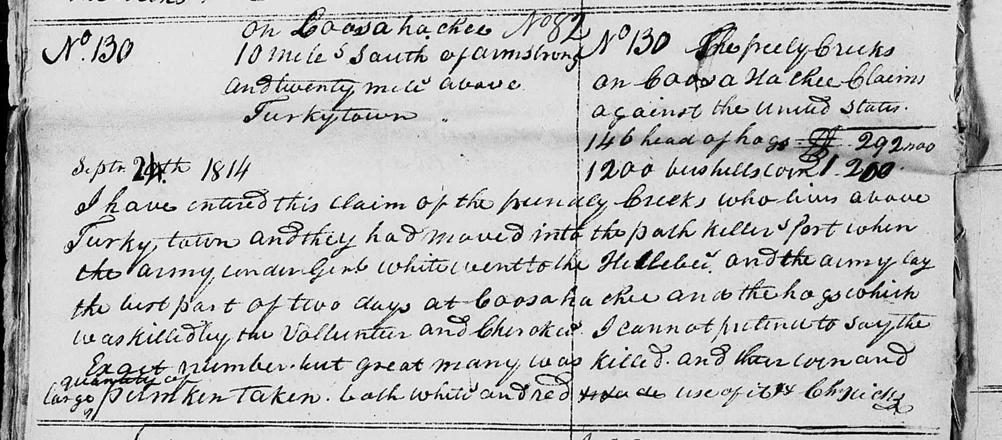
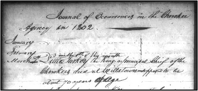
Note on Pathkiller’s Fort. Return J. Meigs to Nathan Lawson Pay Master General, 22 Jan 1820. “Also a number of members of the Cherokee warriors who were stationed at Turkey Town for one month only, in the time of the Creek War 1813-1814. This post camp had no officer to command them they were in a pickeled fort surrounding the resident of the King or Head Chief Pathkiller.“3 This was a request to pay the seventeen warriors for their service.

A modern Google map of Turkeytown, Etowah County, Alabama, shows the original village site of New Seneca, Turkey’s town. Chief Pathkiller on the south end. James Lasley on the north end. The distance between the two is about 5 miles. Google Maps website. Notation in red added by this Researcher.

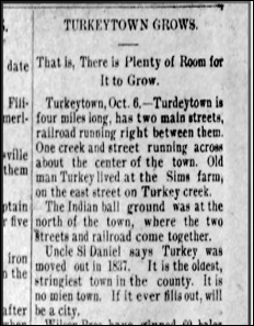
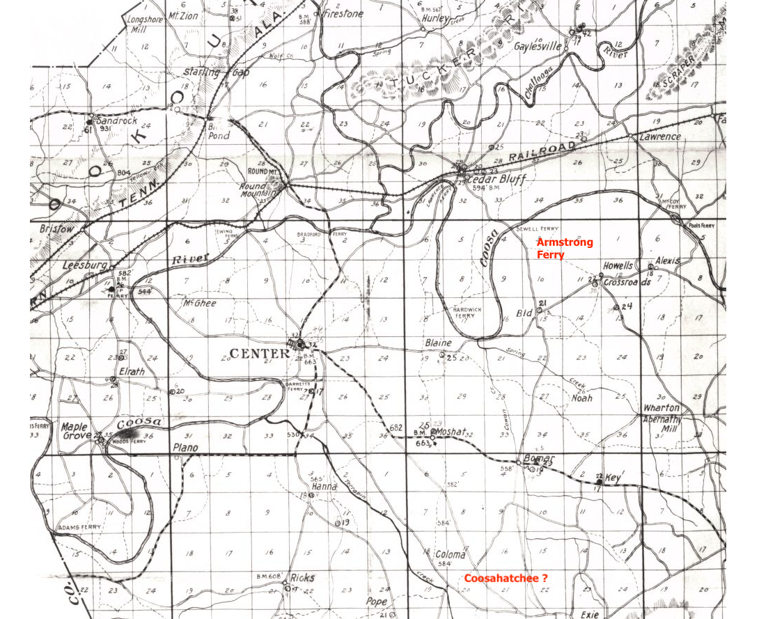
In the prior post on this subject, Chief Charles Hicks stated that friendly Creeks stayed at Pathkiller’s Fort. The fort was located in Turkey Town. The fort is 20 miles below Coosahatachee. Review the post on the Creek War Claims. Coosahatachee is on Terrapin Creek 10 miles below Fort Armstrong.

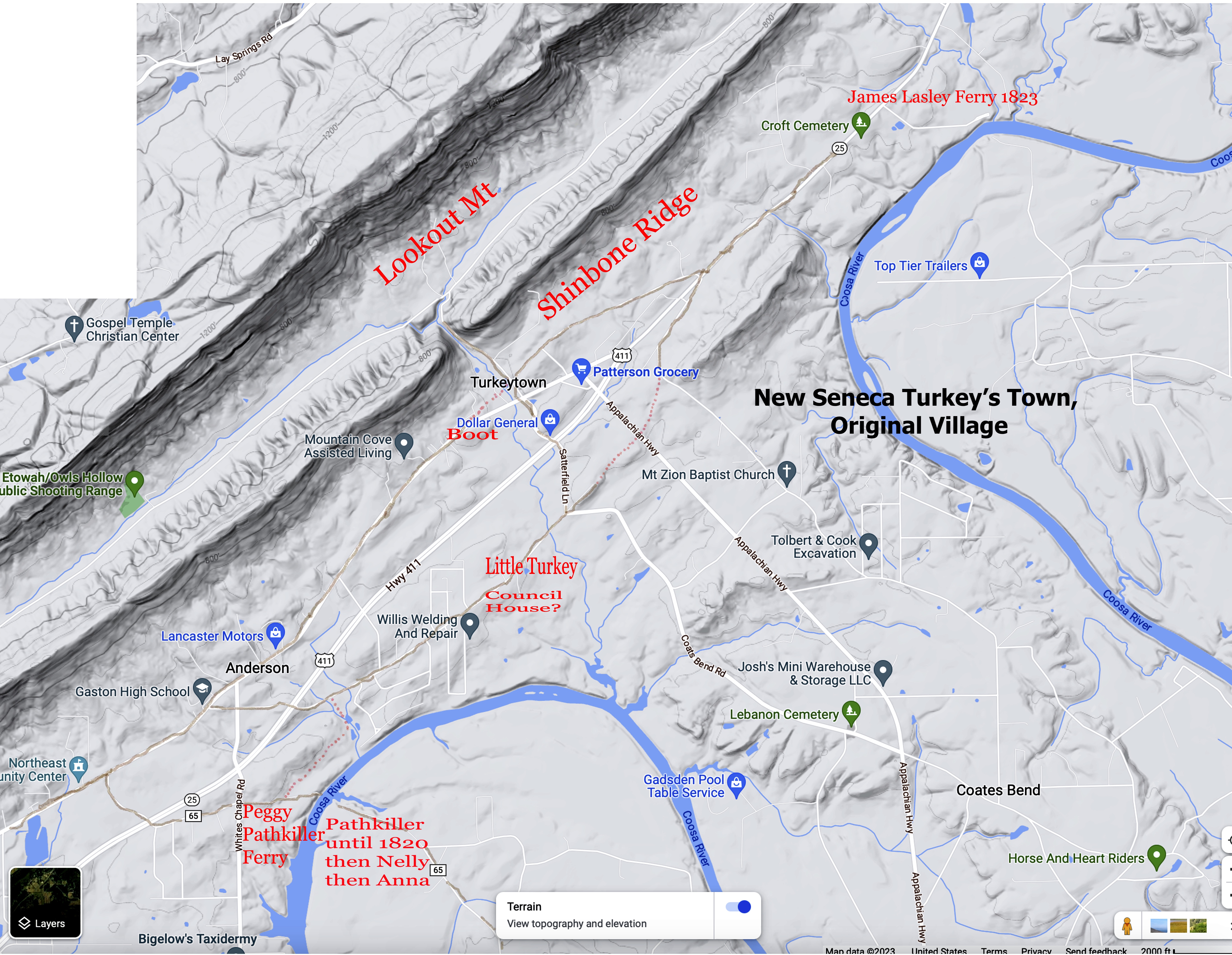
This is confirmation that the original village of Turkey’s Town would start at today’s Fitts Ferry (Pathkiller’s first ferry). This is in Etowah County, Alabama.

The Confirmation of Turkey’s Town by white intruders. The takeover of Peggy Pathkiller’s ferry

White US citizens move into Turkey’s Town. Their actions will confirm the location of Turkey’s Town. They will also confirm Pathkiller’s first residence and ferry.

A Report to the Alabama Chapter of The Trail of Tears, 2007. Chapter 8 Topography of the Removal Routes, Ferry Crossings on Major Rivers and Tributaries by Michael Wren;

COOSA RIVER #8 Township 11 South, Range 7 East, Section 20 

Mrs. Pathkiller’s Ferry / Kay’s Ferry / Fitts Ferry 

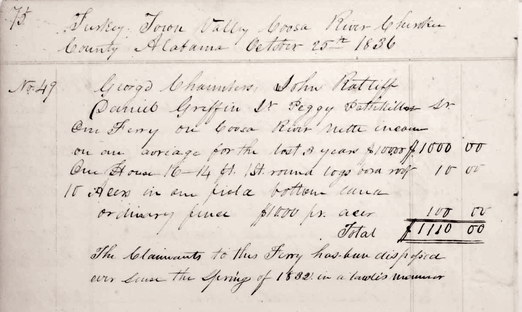
The road from Asheville to Jacksonville crossed the Coosa River in Section 20. George        Chambers, John Ratliff, Daniel Griffin Jr., and Peggy Pathkiller Sr were joint owners of a Ferry on the Coosa River in Turkey Town Valley, Cherokee County. The Valuations gave an average annual income of $100.00. Included with this Valuation was a 16’ x 14’ house and 10-acre field of bottom land under fence. The Claimants were dispossessed since spring of 1832. 

John Ratliff filed a Claim for his ferry on January 16, 1837 before Josiah Harper, Acting Justice of the Peace for Cherokee County Alabama. He stated that the Ferry was 1 ½ mile miles below Turkeytown and was then in the possession of James Kay. He stated, however, that the ferry was taken from him by a white man by the name of Hays shortly after the laws of Alabama were extended over the Cherokee lands in January 1832. The Original Patentee for the ferry’s location was James Kay.4

In the St Clair County court records, James Kay filed for a license to operate a ferry. This was on the Coosa River in the August 1833 term. Mr. Kay stated he acquired the ferry from Hannibald Hays, which was in Turkey Town. 

The Applicant, Kay by attorney moved the judge and commissioners of Roads & revenue that they would grant him license and take a bond for the ferry which the legislature authorized Hanibald Hays (under which this applicant claim by purchase) to establish on the Coosa river where the road crosses the same at the place known by the name of Turkey Town in St Clair County which motion was __-ted and the court refused to grant license or take a bond from the applicant on the grounds they had previously granted to David Gage for the same ferry sometime prior to the act of the legislature giving it to Gage. James Kay by David Gage, St. Clair County, Alabama Court Minutes (1828-1834), Commissioners Court August Term 1833, pages 226-227

Page 172 of the same Court minutes; Order by the Court that David Gage be authorized to keep a ferry on Coosa River at Peggy Pathkillers provided it does not interfear with the Charter limits of John H Garrett as granted to him by the Legislature, at the following rates. . . 5

The above information shows that a white man named Hannibal Hayes took over Peggy Pathkiller’s ferry and property. He would sell it to James Kay and Mr. Kay would patent buy it in 1840s from the US government. Mr. Kay stated he was on the property with a pre-exemption date of 1838. 6 He worked with David Gage to acquire the license to operate the ferry at that location. Notice in the copy of the claim above it states, “in a lawless manner”.

David Gage is married to a Cherokee woman. Her name is Lucy Fish. He has acquired a house and property from the Dragging Canoe’s estate (Chief Pathkiller and Peggy’s son). The family filed a claim in Benton County.

David and Lucy Gage also held property in Will’s Valley. Will’s Valley is where they lived.

The above 1835 document has lots of information. Both Benton (Calhoun) and Saint Clair Counties claimed the area. The area was still in the Cherokee Nation. The document explains Dragging Canoe’s family. Dragging Canoe died about 1827 his estate records are in the Saint Clair County, Alabama estate records. The above document stated the residence for Nelly is next door. Dragging Canoe and his family do not have rights to the improvements. They could not sell the property. Gage and Dragging Canoe’s family lost in claiming the improvements. Chief Pathkiller and Peggy separated about 1816-1817. These improvements would belong to Peggy. Chief Pathkiller “took” a new wife and moved north. Review James Lasley’s statements at the top. Cherokee custom is Peggy would care for and leave her estate to the female children and their families. All of the contested improvements are in today’s Alford’s Bend. (Alford’s Bend will be discussed in its own post.)

If you are reading closely, you see the whites are taking what belongs to the Cherokee people. Read between the lines. James Brown and Tarply Nall both are white and have no connection to the Cherokee. They have moved into the area. Nall will try to buy the land from Sky-ah-too-ka. He stated in an affidavit that he spoke with some of the elder Cherokee and did not purchase the land. He said that Sky-ah-too-ka never owned the improvement. The Cherokee people have not gone to the West. This predates the forced removal of the 1835 treaty. The date is 1832, and Peggy Pathkiller is still living. Peggy died in 1833. Chief Pathkiller died in January 1827. He had moved north and started a new improvement on the Coosa River. He had taken a new wife.

Conclusion

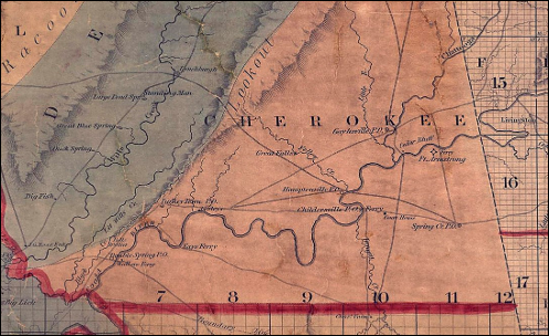
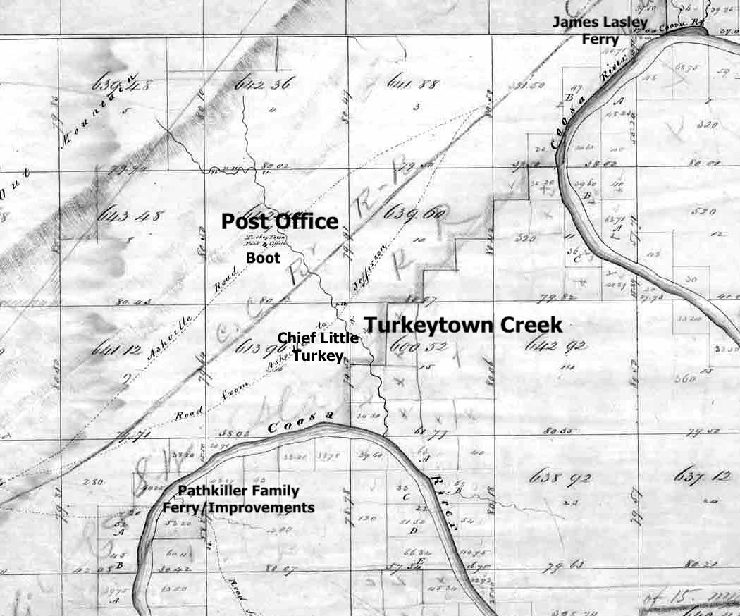
We gather a lot of information on the location of the original village from the above information. The dispute with Pathkiller’s family places the Chief on the east side of the Coosa River. He lives there until he and his wife, Peggy, separate. This is today’s Alford’s Bend. One of the notations above stated the ferry was one-and-half miles below Turkeytown. Turkeytown Creek is one-and-half miles north of Fitts Ferry on the West side of Coosa River.

To recap the last post with this one. Chief Little Turkey lives at Turkeytown Creek on the East Road, (Coats’ Bend Rd.) The Boot lived at Turkeytown Creek on the West Road (Old US 411.) Chief Pathkiller lives on the East side of the Coosa River at his ferry (Fitts Ferry.)

In the next post, I will explain the move north and the new improvements for Chief Pathkiller. “One mile south of present day Centre.” His new wife and an illegal sale of part of his estate. Additionally, I will explain the dispute between the Garrett Family and John Ridge, who acquired most of Chief Pathkiller’s estate. Uncovering the History of Turkeytown, Pathkiller’s Ferry.

  1. Affidavit of James Lasley #574, 12 September 1837, Folder of James Lasley. Miscellaneous Claims Papers, 1836-1839, of the First Board of Cherokee Commissioners, Entry 236; Records of the Bureau of Indian Affairs, Record Group 75; National Archives Building, Washington DC. ↩︎
  2. Affidavit of Quata Campbell Miscellaneous Claims Papers, 1836-1839, of the First Board of Cherokee Commissioners, Entry 236; Records of the Bureau of Indian Affairs, Record Group 75; National Archives Building, Washington DC ↩︎
  3. Correspondence and miscellaneous records 1819-1920 (NARA Series M208, Roll 8), Records of the Cherokee Indian Agency in Tennessee, 1801-1835, Family Search.com, image 420, https://www.familysearch.org/ark:/61903/3:1:3Q9M-CSHM-PQM1?i=419&cat=285733 ↩︎
  4. Report to the Alabama Chapter of the Trail of Tears titled Alabama Collection Camps, Forts, Emigrating Depots and Travel Routes Used During the Cherokee Removal of 1838-1839, Chapter 8 on Topography of the Removal Routes, Ferry Crossings on Major Rivers and Tributaries. Page 248, https://nationaltota.com/alabama-forts-and-camps. ↩︎
  5. John Ratliff’s Spoliation Claim for a Ferry and Improvement. Folder of John Ratliff; Miscellaneous Claims Papers, 1836-1839, of the First Board of Cherokee Commissioners, Entry 236; Records of the Bureau of Indian Affairs, Record Group 75; National Archives Building, Washington DC. In the St. Clair (AL) County Court Minutes (1828-1834) there is a road order on pages 172-173 “Ordered by the Court that David Gage be authorized to keep a ferry on Coosa River at Peggy Path killers provided it does not inter fear with the Charted limits of John H Garrett as Granted to him by the Legislature, at the following rates…” and on pages 226-227 “The applicant James Kay by David Gage attorney moved the judge and Commissioners of Roads & revenues that they would grant him license and take a bond for the ferry which the legislature authorized Hannebald Hays (under whom this applicant claims by purchase) to establish on the Coosa river where the road crosses the same at the place known by the name of Turkey Town in St Clair county which motion was-ted and the court refused to grant license or take a bond from the applicant on the ground that they had previously granted license to David Gage for the same ferry sometime prior to the act of the legislature giving it to Hays. ” See also Acts of Alabama for 1832-1833, Extra Acts, page 150, which Act authorized Hannibal Hays on the Coosa River. 
      ↩︎
  6. Bureau of Land Management, General Land Office Records, Eastern States Office, Springfield, VA. Pre-emption Certificate #6,885 for James Kay of Cherokee County Alabama issued June 1, 1845 for fraction “A” of fractional Section 20 in Township 11 of Range 7 East. Pre-emption Certificate #8,419 for James Kay of Cherokee County Alabama was issued April 10, 1847 for the northwest quarter of the southwest quarter of Section 20 in Township 11 of Range 7 East. Both in the District of Lands subject to Sale at Lebanon Alabama. http://www.glorecords.blm.gov/PatentSearch/. ↩︎

Trust in the Lord with all your heart, and do not rely on your own understanding;
 in all your ways know him, and he will make your paths straight. Proverbs 3; 5-6 CSV

Uncovering the History of Turkeytown, Location By the People of Turkey’s Town,

12 Wednesday Feb 2025

Posted by Jeffrey Sauls in Local History

≈ Leave a comment

Tags

cherokee-indians, native-americans, New Seneca, northeast-alabama-history, trail-of-tears, turkeytown

First, a look at what Historian Mrs. Margaret Stewart, in her Cherokee County History Volume 1 (published 1958), stated on page 204. This is about where Chief Little Turkey lived. 

What do the Cherokee people say? What do the people who interacted with the Cherokee people in Dah-noo-wey-ye (Turkey’s Place) say about the location?

“Turkey Town named for noted Chief “The Turkey” and located in the bend of the Coosa River opposite to and one mile south of the town of Centre. It was founded about 1770, and was considerable size and importance. It is marked on the Royce’s Map (1884) opposite the influx of Terrapin Creek. Chief Turkey lived on the east side of Turkey Creek on what later became the Sims farm. By some Indian agents and traders, the town was called New Seneca.” 

We need to handle this Sims farm and the statements about this before we get to the Cherokee people. It adds too much to the confusion.

Where is this Sims’ farm? You will not find a Sims farm on the West side of the Coosa River opposite Centre Alabama. No Turkey Creek as well. Mrs. Stewart’s reference to the Sim’s farm is a newspaper article from the Gadsden Daily Times News dated 10 October 1899.

Newspaper.com The Gadsden Times-News
Gadsden, Alabama • Tue, Oct 10, 1899 Page 1

The location of this farm is in Etowah County, Alabama. The Sims’ farm is Richard G. Sims. In 1875, R. G. Sims purchased the property from Dr. Walter Baskin. Dr. Baskin had purchased the farm from the estate of Abraham Whorton. Abraham Whorton purchased it in November of 1840. Sims paid taxes on 152 acres in Section 16 of Township 11 & Range 7. This included the Eastern half of the NE and SE quarters. He paid these taxes through 1895. Richard Sims died on August 8, 1893. His wife, Catherine Sevilla Sims, and son, Robert B. Sims, sold this farm to Erastus Darrow in 1903. Mr. Darrow gifts this farm to Amanda McMahan. This is on Coats’ Bend Road, the south side of Turkeytown Creek. The border is Coats’ Bend Road to the Coosa River. The Northern border is Turkeytown Creek.1 2 (A map is at the end of this post.) Uncle Si Daniel is Josiah M. Daniel. He was Sheriff of Cherokee County from 1863-1869. (Coosa River News, page 3, 15 January 1892.) He lived in Leesburg, Cherokee County, Alabama.

It seems that Mrs. Stewart is contradicting herself. Is Turkey’s Town one mile south of Centre, Alabama? Or is it in Etowah County, Alabama at Turkeytown Creek on the Sims’ Farm?

What do the Cherokee people say?

A more precise location of Turkey’s Town is noted by Chief Charles R. Hicks. He is Chief Pathkiller’s second. A second is like the Vice-President of the Cherokee Nation.

After the Creek Indian War of 1813-1814, the Cherokee people sought compensation. They filed for reimbursement from the United States for their losses during the war. From 1814 War Claims;

Sept 29th 1814 I have entered this claim of the friendly Creeks who live above Turkey town and they had moved into the Path Killers fort when the army under Genl White went to the Hillibees and the army lay the best part of two days at Coosahatchee and the hogs which was killed by the vollunteers and Cherokees I cannot pretend to say the exact number but great many was killed and there corn and large quantities of pumkin taken. both white and red made use of it. Ch Hicks.            On the Coosahatchee No. 82 10 miles South of (Fort) Armstrong and 20 miles above Turkey’s Town. 3  

Chief Hicks noted Coosahatchee location that is 10 miles South of Fort Armstrong. It is also 20 miles North (above) of Turkey town. The location of Fort Armstrong was located by archaeologists in 2017. This location is on Alabama Power Company property. Today, this would be on “Pruitt’s Island, Cherokee County, Alabama. This is the location of Fort Armstrong’s Ferry, which became Sewell’s Ferry. Today, this is mostly under the water of Weiss Lake. Travel ten miles South using the original roads you come to Coosahatchee. These roads are plotted on the original survey maps of 1838. This will place you at “Coloma” on Terrapin Creek. The below 1917 Cherokee County Road Map. It shows wagon roads and trails. I have plotted Armstrong’s ferry. Each numbered square is a 1-mile square. You can see where “10 miles South of Armstrong” would be.

http://cartweb.geography.ua.edu/lizardtech/iserv/calcrgn?cat=North%20America%20and%20United%20States&item=States//Alabama//Counties//cherokee//Cherokee1917a.sid&wid=1000&hei=900&props=item(Name,Description),cat(Name,Description)&style=simple/view-dhtml.xsl

Traveling Southwest/west on original roads will place you at today’s Fitts Ferry (Kay’s Ferry), Coosa River, in Etowah County, Alabama. This is the site of Pathkiller’s residence and fort.

John LaTourette’s 1835 Map of Alabama titled An Accurate Map of the State of Alabama and West Florida, published in Mobile Alabama 1838. http://cartweb.geography.ua.edu/lizardtech/iserv/calcrgn?cat=North%20America%20and%20United%20States&item=States/Alabama/LatouretteSheet02.sid&wid=1000&hei=900&props=item(Name,Description),cat(Name,Description)&style=simple/view-dhtml.xsl

Chief Hicks’ location does not agree with James Mooney or Charles Royce. Turkey’s Town has to be 20 miles south of Centre, Alabama. On the above map, Centre, Alabama, is Childersville Ferry and the plot of “Court House.” This is a large distance from Childerville Ferry (Garrett’s Ferry). This notation of Chief Hick’s also would eliminate the tri-river location, as Don Naylor and Bob Minnix noted in 1993. See the earlier post on the traditional location. The Chattooga, Little River, and Coosa Rivers intersections are North and West of Fort Armstrong. This can not be Turkey’s Town.

Chief Hicks has stated that Turkey’s Town is much further South of Centre, Alabama, than what the Historians have stated. Did you review John Coffee’s and Royce’s maps? Just a note on General Coffee’s map: Terrapin Creek is listed as Rocky R.

Mission Teacher/Preacher, 1822, Tells Us the Location

A person deeply connected to the Cherokee people in Wills’ Town and Turkey’s Town is Reverend Daniel Butrick.

Reverend Daniel Butrick was the mission pastor and teacher. He was assigned to Willstown Mission. His assignment came from the Brainerd Mission (Presbyterian Church, American Board of Commissioners for Foreign Missions).

Rev. Daniel Sabin Butrick (or Buttrick) (August 25, 1789 – June 8, 1851) was commissioned in 1817 as a minister of the Word of God, in the service of the American Board of Commissioners for Foreign Missions (ABCFM). His subsequent 25 years were marked with personal failure and relational conflict as he sought to realize his mission to the Cherokee Nation, although his recorded observations concerning the Cherokee removal crisis and Trail of Tears established a legacy. His decision to champion Christian salvation over political advocacy resulted in the creation of an invaluable resource on Indian culture. (From Wikipedia, the free encyclopedia)

In Butrick’s report to the American Board of Commissioners for Foreign Missions, Thirteenth Annual Meeting in 1822, page 44; 

From the journal, which Mr. Butrick kept, a few extracts will be made, and a summary will be given at the close. “19. Rode to the Boot’s, in Turkey-town, twenty-five miles. [This place is the residence of Path-killer, the king, or first beloved man, of the Cherokee nation. Mr. Hicks is the second beloved man.] 4

The information can be expounded on by what he wrote in his personal journal in January 1822. Assisting him was John Arch a converted Cherokee to Christianity, Butrick’s interpreter.

Set off for Wa-sa-si’s, but hearing he was not at home returned [to Browns], took our leave & rode to br. Brister’s 16 miles.  18 Jan 1822

Rode to the Boots in Turkey Town 25 miles.  This man I believe is some like a prince regent.  He attends to business when the king is absent or in ill health, and is his Creek interpreter.      19 Jan 18225

Brown is John Brown, a Pastor and Teacher with the ABCFM at Creek Path, which is now Guntersville, Alabama. Brister’s refers to Warwick Bristow. He settled in a valley that was given the name of Bristow’s Cove. Etowah County, Alabama, has a road named Bristow Cove Road and a stream by the same name. This is now the Aurora Community of Northwest Etowah County on Etowah County road 179. 1829, a post office was established under the name Brister’s Cove at Brister’s store. In 1830, the Brister’s Cove Post Office became the Aurora Post Office.6 If you travel on today’s roads, the distance is 26 miles. It is from Aurora at Bristow Cove Creek to Turkeytown Creek on Old US 411.

After spending most of the day with the Boot and his wife Rev. Daniel Butrick states in his journal on January 23rd, 1822, page 145; 

Road 28-30 miles to the Widow Broom’s near Tas-ty-gi Creek.7  

We can plot the Widow Broom’s location from the journal of L. V. Bierce; Travels in the South Land 1822-1823, pages 91-93.

April 3. Struck our tents and went two miles to Widow Broomes, a half bread who keeps a tavern. One mile from Broomes crossed the Chatooga, a narrow but deep stream over which is a very good Indian ferry. Eight miles from the ferry we crossed the Ecwomisteba or Little River, five miles from which we crossed yellow River. About a mile from the road up the latter river a natural curiosity worthy of notice. It is a perpendicular rock near two hundred feet high, in appearance having windows, doors and other appendages of a castle of the “lands of aulden time”. Viewed from the road, and time forbid a closer inspection, it is subline. The river falls nighty feet perpendicular over rock. It is on Mount lookout, the main branch of the Apalachian Chain. Five miles from Yellow Creek we encamped.  21m8

Bierce has described Yellow Creek Falls in Cherokee County, Alabama, on County Road 273. Start at today’s Yellow Creek and Yellow Creek Falls. Travel along Cherokee County Road 273 till it ends. Then head south on US 411. The route leads to Turkeytown Creek in Etowah County. If you use the old roads as much as they exist, it is 16 miles by automobile. You should add the 13 miles from the Widow Broomes to Yellow Creek, as stated by Bierce. This makes a total of 29 miles. “Road 28-30 miles to the Widow Broom’s“

This again places Turkey’s Town in Etowah County, Alabama.

In both directions, you place Boot and family at today’s Turkeytown Creek.  The heart of Turkey’s Town is on Turkeytown Creek. If the historians are correct, Chief Little Turkey lived on the east road (Coats’ Bend Road). Statement by Uncle Si Daniel in the 1899 Gadsden paper noted above. The Boot lived on the west road (Old US 411) at Turkeytown Creek.

Another note made by Rev Butrick is the Council House was one mile from the Boot. It is one mile in distance between Coats’ Bend Road and Old US 411. This would place the Council House on Coats’ Bend Road.

We accompanied our two fathers the Path Killer i.e. the king, and the Boot, to the council house about one mile distant.  The council house consists of three roofs supported by crotches, each roof perhaps 30 feet long, built in this order viz; (drawing inserted) with a fire in the middle of the yard, and one immediately before each house. Here we found perhaps 100 dear immortals, precious sons and daughters of the forest.  Perfect order and decency were maintained in every part of this assembly as far as we could judge.9

Council House as drawn by Rev Butrick.

Did they place the council house near the Chief? Did Chief Little Turkey live near the Council House? Chief Little Turkey was not at home when he died. He died in March 1802 in Will’s Town. He is buried there.

Journal of Occurrences in the Cherokee Agency in 1802 to Return J. Meigs to the Secretary of War, (Fold3.com of ancestry.com).  

Conclusion

Chief Little Turkey lived on the East Road (Coats’ Bend Rd) near the Council House and Turkeytown Creek. The Boot lived on the West Road (Old US 411) near Turkeytown Creek. The heart of Turkey’s Town is along this creek.

Uncle Si appears to be correct. “Turkeytown is four miles long, has two main streets, railroad running right between them. One street and creek running across about the center of the town. October 1899.

Original Survey 183810 The plotted sites on the above map were done by Jeffrey Sauls. The post office site is the second site for the PO. The post office was established in 1834 at James C. Street, he was the Postmaster. John G. Means became the Postmaster in 1835. The above site is the 1835 site.11

These accounts are provided by the People of Turkey’s Town.

Location, By Chief Pathkiller’s family, is the next post in Uncovering the History of Turkeytown. 

Pathkiller’s family has lots to say about this. They will confirm the original site of Turkey’s Town, Pathkiller’s residence and fort. They will reveal that Pathkiller had two different ferries. He lived in the above-plotted area with his family. He left when he moved north around 1819. He also took a new wife at that time. By doing this, Peggy, his former wife, will take possession of the improvements at his first ferry. The next post is significant to Uncovering the History of Turkeytown.

  1. Etowah County Land Plat records, Historic Plats, Etowah County Commission web site, https://etowahcounty.org/historic-plats/ Etowah County Abstract Company, 314 Chestnut Street, Gadsden, Alabama, ledger book information of said property ↩︎
  2. Will of Richard G. Sims from probate records of Etowah County Alabama 1893 found at FamilySearch.com https://www.familysearch.org/ark:/61903/3:1:33S7-9RRL-S34L?wc=MXRW-ZP6%3A314244401%2C317480301%26cc%3D1978117&cc=1978117&i=18 ↩︎
  3. Cherokee Claims War of 1812, List #82 Frame 121, Pathkiller Claim; NARA Microfilm M574 [Special Files of the Bureau of Indian Affairs].  Roll 17, Special File 104 [Claims for losses suffered by Cherokee Indians, particularly during the War of 1812]. https://www.familysearch.org/ark:/61903/3:1:3Q9M-CS5F-17GB-L?i=6&cat=362686 Digital image 129.  ↩︎
  4. Report of the American Board of Commissioners for Foreign Missions, Thirteenth Annual Meeting 1822, page 44, Daniel Butrick, Yale University, https://findit.library.yale.edu/catalog/digcoll:445026.  ↩︎
  5. Report of the American Board of Commissioners for Foreign Missions, Thirteenth Annual Meeting 1822, page 47, Daniel Butrick, Yale University, https://findit.library.yale.edu/catalog/digcoll:445026 ↩︎
  6. U. S. Appointments of Postmasters 1832-1971, ancestry.com. ↩︎
  7. Mission Among Us, the Cherokee Journal, February – August, 1823, by Reverend Daniel Butrick, The Missionary Herald, January, 1824, University of North Carolina, Chapel Hill. https://archive.org/details/missionamongcher00butr.  ↩︎
  8. “Travels in the South Land 1822-1823”, pages 91-93. The Journal of Lucius Verus Bierce. Gadsden Public Library.  ↩︎
  9. Mission Among Us, the Cherokee Journal, February – August, 1823, by Reverend Daniel Butrick, The Missionary Herald, January, 1824, University of North Carolina, Chapel Hill. https://archive.org/details/missionamongcher00butr. Pages 143-144. ↩︎
  10. Survey of Township 11 South of Range 7 East, of the Huntsville (AL) Meridian, Section 9. Plat certified April 20, 1840, by James W. Weakley, Surveyor General of the public lands in Alabama. Samuel Bigham, Deputy Surveyor.http://www.glorecords.blm.gov/SurveySearch/.  ↩︎
  11. U. S. Appointments of Postmasters 1832-1971, ancestry.com ↩︎

Trust in the Lord with all your heart, and do not rely on your own understanding;
 in all your ways know him, and he will make your paths straight. Proverbs 3; 5-6 CSV

Subscribe

  • Entries (RSS)
  • Comments (RSS)

Archives

  • December 2025
  • November 2025
  • October 2025
  • September 2025
  • August 2025
  • July 2025
  • June 2025
  • May 2025
  • April 2025
  • March 2025
  • February 2025
  • January 2025
  • December 2024

Categories

  • Local History

Meta

  • Create account
  • Log in

Website Built with WordPress.com.

  • Subscribe Subscribed
    • New Seneca Turkey's Town
    • Already have a WordPress.com account? Log in now.
    • New Seneca Turkey's Town
    • Subscribe Subscribed
    • Sign up
    • Log in
    • Report this content
    • View site in Reader
    • Manage subscriptions
    • Collapse this bar
 

Loading Comments...