• Home
  • About
  • Alabama Chapter Trail of Tears Association
  • National Trail of Tears Association
  • Local History

New Seneca Turkey's Town

~ Uncovering the History of Turkeystown, a Cherokee Village/Town in Northeast Alabama

New Seneca Turkey's Town

Monthly Archives: March 2025

Uncovering the History of Turkeytown, Establishment, A Timeline

18 Tuesday Mar 2025

Posted by Jeffrey Sauls in Local History

≈ Leave a comment

Tags

cherokee-indians, native-americans, northeast-alabama-history, trail-of-tears, turkeytown

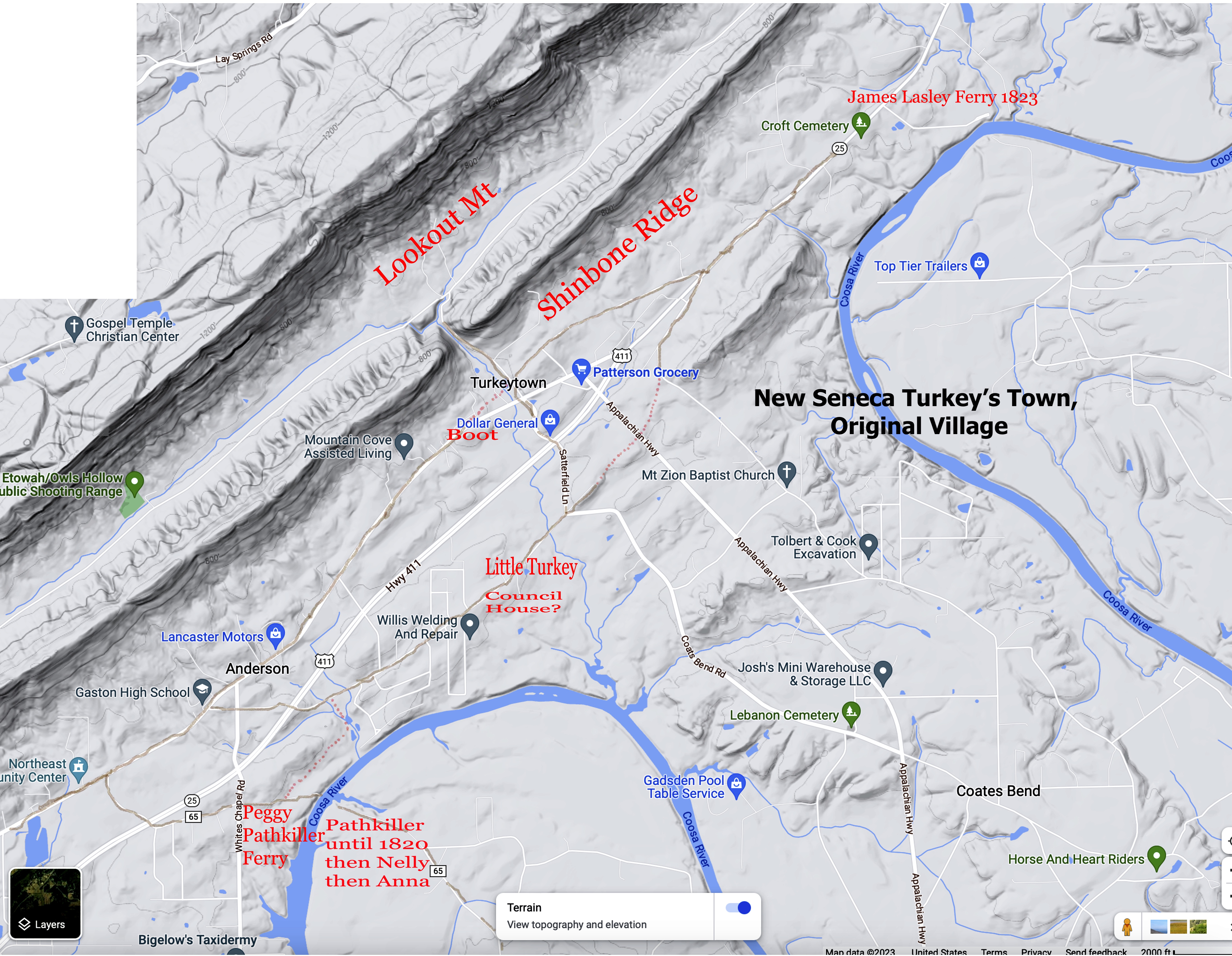
When did Chief Little Turkey move to this location? Was there a reason for choosing this place?

A 1961 undated Civil War Centennial Edition of Gadsden Times, article; “Indians Lore Abound in Turkey’s Town Area,” by Elbert Watson1

“It was founded about 1770 by a minor Cherokee Chieftain, Little Turkey.”

“The Turkeytown Story”, a booklet written by the Turkeytown Methodist Church 1953, Etowah County, Alabama, sold as a fundraiser to help finance their new church building, they state on page 3;2

There was a day, in 1770, when Turkeytown was the thriving Capital of the Cherokee Indian Nation. It was ruled by the iron hand of the great Cherokee Chieftain “The Turkey.”

Oliver Day Street “The Indians of Marshall County Alabama”;3

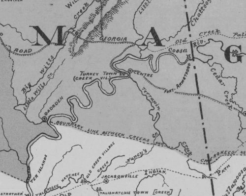
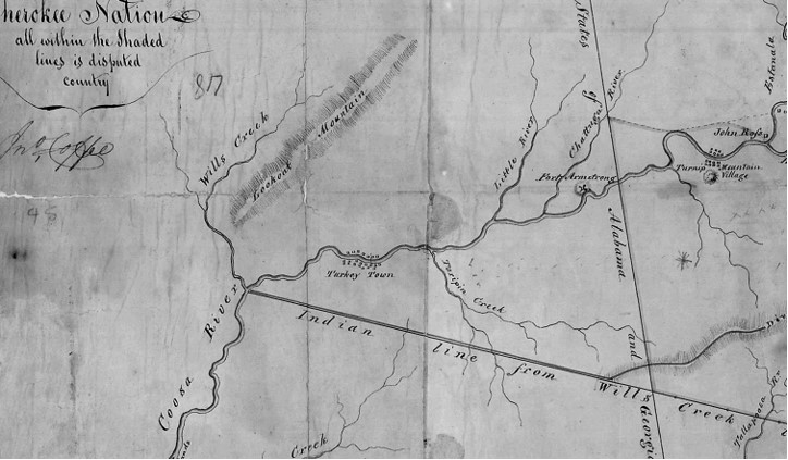
About 1777, Wills’ Town was established by the Cherokee. . .about the same time Turkey Town was built by them on the Coosa river opposite the present site of Centre, Cherokee County, Alabama. (“Pickett’s History of Alabama”, vol I, page 163; Royce in the 5th Annual Report Bureau of Ethnology, Map 8)

Where did this 1770 information come from? What is the source? Albert James Pickett’s History of Alabama is listed in Mr. Street’s Marshall County Alabama history. Is that the source?

Will’s Town and Turkey Town—important Cherokee establishments. The former was
named for a half breed called Red-headed Will. At these towns lived the British
Superintendent, (the celebrated Col. Campbell,) before and during the Revolutionary
War*.
* Indian Affairs, vol. 1, pp 264-269.4

Historical Society Commission wrote a History of Alabama for the Governor in 1900. In this report, they list two different Turkey’s Town. One is a Cherokee Village and one is a Creek Village. They state it was “Founded about 1770.”5

Mrs. Stewart Cherokee County History. It was founded about 1770, and was considerable size and importance. Turkey Town was established some time prior to 1770 and was one of the most important Cherokee establishments. Col. Campbell the noted British soldier and superintendent lived here at times during the Revolution.6

The confusion about the location and the fact that it is Cherokee town has been proven in the earlier post. Now to settle the confusion on when. Where did 1770 come from? There is NO SOURCE or REFERENCE to 1770 by any of the early historians or writers. Is it a guess, a speculation, I believe or what. No one gives a clue to why they used this date. The only thing I can find as a possible reference is Albert Pickett’s statement of “Colonel Campbell.”

Will’s Town and Turkey Town—important Cherokee establishments. The former was named for a half breed called Red-headed Will. At these towns lived the British Superintendent, (the celebrated Col. Campbell,) before and during the Revolutionary War*.7

* Indian Affairs, vol. 1, pp 264-269.

An extensive search for Colonel Campbell results in very little information. There is no
information showing he was the agent assigned to the Cherokee during the American
Revolution. The agent assigned to the Cherokee during that time was Alexander Cameron. He was appointed by Colonel John Stuart. Cameron answered to Royal Governor Joseph Martin. Hugh McCall’s “History of Georgia”8 Alexander Cameron died on 27 September 1781. John Graham replaced him. At this time, Alexander Campbell became his Chief Deputy Superintendent, notes from the 9th Circle blog; Chuck Hamilton.9

This appears to be the only reference. If Alexander Campbell is Col Campbell, he became the agent in the latter part of 1781. It is during this time frame that the Revolutionary War is coming to an end and is all but over.10 So one could say that Campbell is the agent during the American Revolutionary War. But the timeline is at the end of 1781. This is NOT 1770 or close to it.

1770 is Wrong

Wikipedia has this for a timeline or date on settlement. Turkeytown was settled in 1788. The town was established by Little Turkey during the Cherokee–American wars as a refuge for him and his people from the hostilities then being engaged in between the Cherokee and the American frontiersmen.11 Wikipedia has a lot of mixed info on Turkey’s Town. However, this date might be the closest to being correct. Wikipedia does not have a reference or source to the date.

Are there any references to give us a better timeline?

The Cherokee-American wars, along with the signing of the Hopewell Treaty in November 178512. This is the most likely reason for Little Turkey and the people of Seneca to move from their homeland. We have proven that Little Turkey was from Seneca. “When a Name is Not a Name” post. The lower towns on the headwaters of the Savannah River were given up in the treaty. After that, the people started moving.

Little Turkey does align himself with the Chickamauga Chiefs that are a part of the Cherokee-American wars. Dragging Canoe, and Hanging Maw. This letter is written for Chiefs, Little Turkey, Hanging Maw, and Dragging Canoe. The letter is intended for Governor Samuel Johnson in 1789 (Governor of the State of North Carolina). The context of this letter is to seek arrangements for another peace treaty. This treaty should be similar to the 1785 Hopewell treaty or adhere to that treaty.

At a general meeting held at the Little Turkey’s Town or otherwise called new Sinekaw in the Cherokee Nation Present the Chicamagies Chiefs March 10th 1789 . . . that you are willing to adjust and rectify the dispute between your people and our own __ to establish a lasting peace in our hearts desire . . .

Little Turkey Hanging Maw Dragging Canoe13

No Turkey’s Town until after 1782

We can now start a timeline for the settlement of Turkey’s Town. After 1782, before 1788.

From the American State Papers; Indian Affairs Vol 1; page 431; Letters, with their several enclosures, from Governor (Wm) Blount to the Secretary of War. (Henry Knox);
Knoxville, January 14, 1793
(fourth paragraph) At the beginning, and previous to the late Revolution, the Cherokees lived in towns, either on the head waters of the Savannah River or on the Tennessee, above the mouth of Holston. . . .That, in the year 1776 General Williamson marched an army from South Carolina, and destroyed the towns on the Keowee and Tugelo, among them old Seneca, a very principal one, and erected fort Rutledge on its ruins. . . . The Cherokees being thus burnt out of their towns, and by these treaties (1st Long Island 1777 and Long Island of the Holston 1781) very much curtailed in their hunting grounds to the eastward and northward, shortly began to erect new towns, lower down the Tennessee, and on the waters of the Mobile River. The most bold and active part settled on a creek called
Chickamauga, 100 miles below the mouth of Holston. . . . In the year 1782 they
abandoned Chickamauga creek, believing it was infested with witches; some returned to
the old towns, others went lower down the Tennessee, 40 miles, and laid the foundation
of the five towns, now generally called the five Lower towns on the Tennessee. .
.14

A very similar reference is documented in a Nashville Newspaper in 1816.

That at the time of Christian’s campaign in 1776, there were no Cherokee towns on the Tennessee below the mouth of the Holston, and that the lowest belonging to the nation was on the Hiwassee.

That the peace which followed the campaign of 1776 was protested against by the Dragging Canoe, a Chief of note, who in consequence of his dissent from the rest of the national council, descended the river, with his adherents in the winter of ’76 & ’77, and settled at Chickmawga, where he continued the war, attacking almost every boat which descended the river, until the spring of 1779, when a party of whites commanded perhaps by one of the Shelby’s, beat him off, and destroyed his town. That after the destruction of Chickmawga the Cherokee made their first settlement at Nickajack and Running Water, and to the south west at Turkey Town and Will’s Town.

That these settlements were made with the permission of the Creeks, is a fact, so notorious, that it is unnecessary to give evidence in support of it. It was a subject of negotiation between the two tribes and we have it on the most respectable authority, that at every national council, which has been held in the Creek Nation, the Cherokee, have been reminded of the grant by which they held the country between the Highwassee and the Creek Path.

A friend has furnished us with the words of a Creek talk which was sent, to the Cherokee about five years ago. He is confident it is very little variant even in words, from the preceding messages, which had followed each other from ’79 to that time. It is as follows:

“The White people have drove you off your land, and you come on our land, as you must live, we let you stay, but you know that the land is our land; and we let you live on it.15

The above references state there are no Cherokee Towns or Villages in what would become Alabama until after 1782. The movements and treaties prove Turkey’s Town was not establish until after 1785. It may have been settled then during 1786. This does not mean that Cherokee people did not live in what would become Alabama, but no towns or villages.

Other references.

General John Coffee was the surveyor of Alabama. He states this in his report and explanation on the boundary line between the Creek and Cherokee. The report is dated 1829, December 30, in Florence, Alabama, to John H. Eaton.

There is abundance of evidence shewing that the Cherokees had the South bank of Hightown river fifty years ago at the old Hightown town, and that they extended their settlements out from that town, as well down as up the river. Turkey town was settled 40 years ago, and the old red Creek Town upwards of forty years since, and various other villages and settlements were made and occupied on all the waters that run into the Hightown and Coosa rivers above Turkey town 30 to 40 forty years ago and have ever since been in the constant occupancy of the Cherokees without any evidence to shew the Creeks ever set up any claim to any of the waters of those rivers above Turkey Town except the statement of 29 Creek chiefs and warriors given to me in 1816 in the absence of the Cherokees. By that statement they said many years since, and during the revolutionary war, they loaned the Cherokees land from their old line, the junction of Estanala & Hightown down to Wills Creek, and that the Cherokees had lived on it ever since and had not been reclaimed by the Creek. .16

A portion of the map Sketch of the Disputed Country Between the State of Georgia and the
Cherokee Nation, Record Group 75, Records of the Bureau of Indian Affairs, 1793-1999, Series,
Central Map Files, 1824-1962, National Archives Catalog, General John Coffee.

From “The Cherokee Phoenix” Published June 19, 1830 Page 2 Column 1a-2b

The undersigned came into the Cherokee Nation in the year 1785-and opened a store at Stecoe in the Lookout Valley and there married the daughter of Mr. John M’Donald, and about the year 1788, he removed together with his father in-law and their families to Turkey Town, and continued trade with the Cherokees. The Little Turkey was the Principal Chief of the Cherokee Nation and resided in that town-and that the Cherokees had considerable settlements from the mouth of Will’s Creek, up the Coosa River on both sides of said river,

Head of Coosa, Cherokee Nation, December 10th, 1829. DANIEL ROSS.17

“The Cherokee Phoenix” Published May 29, 1830 Page 4 Column 1b-3b.

Old Red Bank, Cherokee Nation Southside Hightower,
10th December 1829
John Wright, a white man married to a Cherokee wife, states that he came into this
nation when a boy-he does not know his age correctly, but he thinks he was about
twelve years of age. . . Turkey Town on the Coosa river is the lowest down the river
where there has been any Cherokee settlements that he knew of, they settled that place
on both sides of the river about forty years- since. . .
18

These references lead to a timeline of 1788 to 1789. The above letter from Turkey’s Town, though, has a date of March 1789. So, the timeline would be before 1789.

Conclusion

The 1770s dates are not supported by any reference. The date of settlement is somewhere between 1782 and 1788. My thoughts are 1786-87. This is based on the movements of the people and the Cherokee-American Wars.

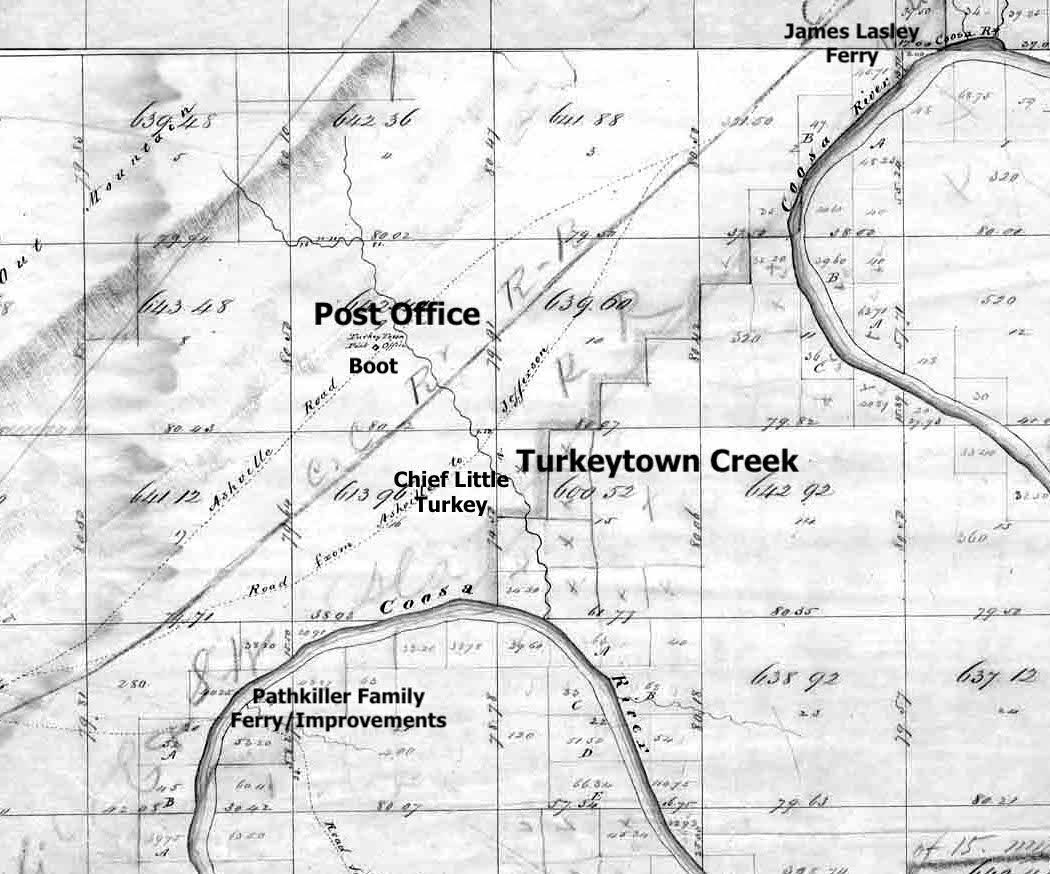
Little Turkey was looking for a safe place to settle his New Seneca. Did he meet up with someone to show him that safe place? Chief Little Turkey’s Creek interpreter is Boot (Chulioa). Rev Daniel Butrick stated he was “full blood Cherokee raised by the Creek”. Did he guide Little Turkey to a safe place on the trading route (Hightown Pass) along the Coosa River? Was it safe to settle there?

There is a track of land lying on Wills Creek and between that creek and the Coosa River on the West side of the latter, and north of the Treaty line of Fort Jackson which they may be prevailed upon to part with, in treating for which they are willing to discuss and settle the subject of the boundary between them and the Cherokee. They however contend that their present boundary with the Cherokee is by the Suwannee path where it leaves the Western line of Jackson County to the old town on the Chatahotchie River and from thence by a drift line to the Mouth of a certain water course called by them, Little River where it unites with the Coosa. They have furnished me with a copy of certain question put by the Creeks to an old Cherokee Chief and the Cherokee Interpreter (who was their mutual Interpreter on the first settlement of the Cherokee in the Creek Country) . . . 19

The above notation is from Acting Secretary of War George Graham to Creek Agent David B. Mitchell, 31 October 1817. It is explaining the Creek boundary. The letter is recorded in Alabama Territory, Territory papers, page 183-84. The above is a footnote.

This statement is about Little Turkey and Boot. They have furnished me with a copy of certain question put by the Creeks to an old Cherokee Chief and the Cherokee Interpreter (who was their mutual Interpreter on the first settlement of the Cherokee in the Creek Country). Boot showed Little Turkey a safe place to settle. Boot died at his home in Turkey’s Town in 1827 as noted by his son Laugh at Mush.

What is next? The Beloved Chiefs from Turkeytown, Chief Little Turkey.

  1. 1961 undated “Civil War Centennial Edition of Gadsden Times”: Copy in possession of the writer. ↩︎
  2. “The Turkeytown Story”: Turkeytown Methodist Church: Mrs. Eva McCarver, Miss. Imelda Anderson, and Reverend Jack Dillard: 1955. Copy in possession of the writer. ↩︎
  3. “The Alabama Historical Society, Montgomery, Alabama, Reprint No. 8”: XII The Indians of Marshall County, Alabama, Montgomery, Alabama, 1904, page 206: Oliver Day Street, Guntersville, Alabama: Google Books eBook: page 185. ↩︎
  4. “History of Alabama and Incidentally Georgia and Mississippi From Earliest Period”: Albert James Pickett: Volume 1: Charleston North Carolina: McKee and James: 1851: Google Books eBook: Public Domain. ↩︎
  5. Publication of the Alabama Historical Society Miscellaneous Collection: “Report of the Alabama Historical Commission to the Governor of the State of Alabama December 1, 1900”: Edited by Thomas McAdory Owens, Chairman: Montgomery Alabama: 1901: Google Books eBook: Public Domain. ↩︎
  6. “Cherokee County History 1836-1956 Volume 1”: Mrs. Frank Ross Stewart: Centre, Alabama:1956. Gadsden Public Library. Page 204, and 214 ↩︎
  7. “History of Alabama and Incidentally Georgia and Mississippi From Earliest Period”: Albert James Pickett: Volume 1: Charleston North Carolina: McKee and James: 1851: Google Books eBook: Public Domain. Page 163 ↩︎
  8. “The History of Georgia Containing a Brief Sketch of The Most Remarkable Events Up to Present Day”: Captain Hugh McCall in Two Volumes: Vol 1: Savannah, Seymour and Williams: 1811: Page 365: Google Books eBook: Public Domain. ↩︎
  9. 08 August 2011 Cherokee-American Wars (1775-1795), Notes from the Ninth Circle, Chuck Hamilton, https://notesfromtheninthcircle.blogspot.com/2011/08/chickamauga-wars-17761794.html ↩︎
  10. https://www.nps.gov/subjects/americanrevolution/timeline.htm ↩︎
  11. https://en.wikipedia.org/wiki/Turkeytown_(Cherokee_town) ↩︎
  12. Clemson University; Clemson.edu; The Hopewell Plantation; The Hopewell Treaties; https://www.clemson.edu/about/history/properties/hopewell/hopewelltreaties.
    html#:~:text=Hopewell%20Treaty%20Site&text=Three%20hundred%20yards%20northwest%20of,America%20and%20the%20Cherokee%20Nation. ↩︎
  13. Document NCU16 in the Papers of the War Department 1784-1800, Roy Rosenzweig Center for History and New Media, George Mason University, wardepartmentpapers.org. ↩︎
  14. A Century of Lawmaking for a New Nation: U.S. Congressional Documents and Debates, 1774 – 1875, American State Papers, Senate, 3rd Congress, 1st Session, Indian Affairs: Volume 1, page 431, https://memory.loc.gov/cgibin/ampage ↩︎
  15. National Banner and Nashville Whig (Nashville, Tennessee, 25 June 1816, page 3), The Indian Treaty. A reprint from the Knoxville Gazette. Newspaper.com ↩︎
  16. Digital Library of Georgia: Treaty of Hopewell: Galileo, Georgia Virtual Library: Coffee, John, 1772-1833. “Report of General John Coffee on the boundary line between the Creeks and Cherokees, 1829, Dec. 30, Florence, Alabama [to] John H. Eaton / Jo[h]n Coffee.” 1829-12-30. March 11, 2021.
    https://dlg.usg.edu/record/dlg_zlna_tcc697#item. ↩︎
  17. CHEROKEE PHOENIX, Issue 31, November 11, 1829
    https://www.wcu.edu/library/DigitalCollections/CherokeePhoenix/Vol2/no31/. ↩︎
  18. Ibid ↩︎
  19. https://babel.hathitrust.org/cgi/pt?id=mdp.39015010692468&seq=208 page 183-184 ↩︎

Trust in the Lord with all your heart, and do not rely on your own understanding;
 in all your ways know him, and he will make your paths straight. Proverbs 3; 5-6 CSV

Uncovering the History of Turkeytown, Pathkiller’s Ferry.

04 Tuesday Mar 2025

Posted by Jeffrey Sauls in Local History

≈ Leave a comment

Tags

Centre Alabama, cherokee-indians, Chief Pathkiller, native-americans, New Seneca, northeast-alabama-history, Pathkiller Ferry, Pathkiller Grave, trail-of-tears, turkeytown

In the last post, we proved that Chief Pathkiller lived in Turkey’s Town. He had a ferry on the Coosa River. We saw that a fort was built around his residence. His wife Peggy would keep this ferry. His children would live on the property on both sides of the Coosa River. All of this is in Etowah County, Alabama, Near Gaston School on US 411 North. It confirms the original location of Turkey’s Town.

New Improvement

This post explains Chief Pathkiller move. “One mile south of present day Centre.” We learn of a new wife and an illegal sale of part of his estate. Additionally, let’s look at the dispute between the Garrett Family and John Ridge. John Ridge acquired most of Chief Pathkiller’s estate at the Centre, Alabama location. Uncovering the History of Turkeytown, Pathkiller’s Ferry.

The affidavit of James Lasley. “The grandfather of this claimant Anna Pathkiller being the person who made the first improvement and kept it and held it legally as his according to the Law and usage til about the year 1815 ”

What happens? Did Peggy send him packing? Did he abandon the family? What was going on in history at this time?

Influx of White People

Chief Pathkiller became the “King” or Principle Chief in 1811 after Black Fox’s death. The Creek war ended in 1814. During that time, “Friendly Creek” was living at Chief Pathkiller’s cabin. A “fort” was built around it. A treaty ratification took place at Turkey’s Town in October 1816. The US Army, under the command of Maj Gen. Andrew Jackson, came to sign this treaty. (The 1816 Turkey Town Treaty is a post later.) The US government signed treaties in 1817 and 1819.

The Creek War brought the US Army, that was made up of Tennessee Volunteers. There were mixed families in the Cherokee people. They have married white people. But now, it must have felt like an invasion of strangers taking everything. Friendly Creeks living in the front yard. The yard had been fortified. Two years later, more soldiers. Andrew Jackson came with an escort for the treaty signed in 1816. The 1816 treaty strongly talks about moving the whole nation West of the Mississippi River. Is this more than Peggy wanted?

Oo-loo-cha, the New Wife

It is the custom of the Cherokee people that the female controls the marriage. Peggy might have dissolved the marriage. We do not have a clue as to what happened. We do know that the separation happened between 1815 and the Treaty of 1819. His daughter Nelly told James Lasley about 1815. (See Lasley’s statement above.) Hammer, the son of Oo-loo-cha, stated 1819, see below.

Al 19 4th Board of MD, Vol 1, pages, 13-14,45,189-190-191, Ahamah #24 Claim

“after the treaty of 1819, she married Path-killer the chief of the nation, abandoned her reservation and removed with him to Turkey-town.”

The above two selections of Hammer’s 1846 claim are based on his mother’s reservation. Chief Pathkiller married Oo-loo-cha just after the 1819 treaty.1 Hammer’s father is Fawn Killer, and he died before 1819.

The claim by Hammer is on the estate or improvements last held by Pathkiller. This is the ferry and property at Terrapin  Creek today’s Centre, Alabama. Hammer sold part of this estate to a white man named Robert Brown.

Michael Wren discovered a file box on Pathkiller. This was in the collection of Penelope Allen Johnson. It was located at the University of Tennessee in Knoxville. There were several folders about a dispute in the Cherokee District Court at Chattooga. This court was located just Northeast of today’s Gaylesville, Alabama. By Cherokee law, to settle disputes between the people, it was done in the Cherokee district court.

Tah-ka-ha-kee & Crying Snake vs Robt Brown

Plaintiffs witness May 26th 1830 

Ahnoah Deposeth and saith that she was living in the neighborhood of Gunters Landing when her uncle the Bears Meat told her that the Pathkiller wanted her the Deponent to come and live where the Pathkiller was clearing a place on the Couse River on the West Bank at Pathkillers Ferry so called; the Pathkiller told her that he would get some young men to build some houses, and bout one year after the Pathkiler brought the Hammer there with his mother the Pathkillers wife. 

How long did the Pathkiller settle at the ferry? Ans; He lived there until he died.  Did he ever move opposite? Ans; No  Did he die where he was clearing? Ans; He died at the house.  Which side of the river did the Pathkiller die? Ans On the East side2 

We learn a lot from this court case. This notation from the witness Ahnoah tells us she is the granddaughter of Pathkiller. She was living near Gunter’s Landing or Creek Path. She calls Bear Meat her uncle. This indicates that her mother is Bear Meat’s sister. Proven by Cherokee custom. Bear Meat is the son of Pathkiller by an unknown wife.3

Chief Pathkiller had a house built for her. She stated he died in his house on the east side of the River. This was at his (New) Ferry.

The two people bring this case to court are Tah-ka-ha-kee and Crying Snake. Tah-ka-ha-kee is the son of Pathkiller by an unknown wife. Is he the brother of Bear Meat? Crying Snake is the son of Nancy, Chief Pathkiller and Peggy’s daughter. Crying Snake produced a note. Principal Chief John Ross stated in this note that Pathkiller had willed the improvements at this location to Crying Snake. Neither one of them had a copy of the will.

This is to certify that the Path Killer some short  time prior to the death of my Grand Father was at my house where I lived near the Look Out Mountain, and got me to write a will for him respecting his ferry and possessions on the Coosa River which as well as my memory serves me was a follows – That after his Death his Grand Son Crying Snake should inherit his ferry and possession and that in case he the said Crying Snake should think it proper to receive Ahamah and associate him in interest with him that it should be discretionary with himself, so to do but that the Crying Snake should stand foremost and do as may appear best to himself – Given under my hand at the Head of Coosa this 16th day of Feby 1830.                                        /s/ John Ross 

Chattooga court house, Cherokee Nation, May 25th 1830

I do hereby certify the Def____  the l_____ as ea____ in t_____ to my hand Robert Field, Clk CC4

This case settled in Crying Snake’s favor.

RECORD BOOK OF THE CHEROKEE SUPREME COURT October Term 1830

[PAGE 72]

Crying Snake Vs Robert Brown}}}Treppes to try the right to a certain field at Pathkillers Ferry on the West side of the river.

The Court find for the plaintiff, Crying Snake, the field in dispute.

Witnesses attendanceM. McIntosh14 days$10.50
 John Ratliff17 days12.75
 Anohy1612.00
 James Lasley1511.25
 Quakey32.25
 Qakey21.50
 Kenah64.50
 Kah-lo-ne-sky32.25

Friday 27th (October 1826) The Court met according to adjournment.  Present &C5

Pathkiller started a new improvement, according to the court case. This improvement held a ferry and a farm on both sides of the Coosa River at Terrapin Creek. He lived on the east side and had a house built for his granddaughter Ahnoah. She stated in testimony that she was married to Hammer at one time. She said that her grandfather Chief Pathkiller died in his house on the east side of the river. Cherokee custom, he would be buried on-site at his death. So, Chief Pathkiler is buried at this location. He had a new wife named Oo-loo-cha.

John Ridge and the Ferry

“Alabama Collection Camps, Forts, Emigrating Depots and Travel Routes Used During the Cherokee Removal of 1838-1839,” Chapter 8, Michael Wren wrote;

After Pathkiller’s death, controlling interest in the ferry was acquired by John Ridge while some members of Pathkiller’s family continued to hold a minority interest. John Ridge employed a white man named William Childers to operate the ferry. It is likely that William Childers was the source of the name Childersville.6

In 1832, St Clair County authorized Emanuel M. Zimmerman to establish a ferry on the Coosa River. 7 Zimmerman assigned that right to John H. Garrett. Garrett used that right to dispossess Ridge and Company their ferry on the Coosa River.8 (The footnote contains lots of additional information.)

In a letter Benjamin Curry to Governor Gayle of AL dated January 21, 1835., William Childers and John Ridge complained about Garrett building on the property.

“General John H Garrett came with an armed force and is now building a dewilling house in the yard of one of Ridges’s tenets between the Indian dwelling and his little patch separated by a distance not under sixty feet.“9

Charles C. Royce Map section showing Turkey Town, earlier cited.

The Garrett family confiscating this property created great confusion as to the location of Turkey’s Town. Along with the above map, the historians became confused on where Turkey’s Town was located. This was not part of Turkey’s Town until after 1819 and Chief Pathkiller establishing a new ferry and resident.

John Ridge would surrender this property under the 1835 New Echota Treaty.

John H Garrett and his wife Mary would patent purchase this property.10 This is the site that Charles C. Royce and James Mooney would site as Turkey’s Town. The Garrett family tradition states they were on this property in 1816. William H Garrett was the oldest son of John H Garrett and Mary Hall Garrett. He stated this in a bio for the state of Alabama. He said he was born “22 February 1819 near Hamburg, Edgefield County, South Carolina.” John H Garrett is on the 1830 St Clair County, Alabama Census. In St Clair County court records he is listed as a Justice of the Peace. He will become a Major in the Alabama Militia by 1835. He died in 1841 while serving the Alabama Legislature in Tuscaloosa, Alabama. The Garrett family still owns this property today.

Conclusion/Confusion

Confusion. A lot of info in the past three posts. Review them. Chief Pathkiller had two ferries. His first ferry is the location of today’s Fitts Ferry in Etowah County, Ala. He separated from his wife, Peggy, and left those improvements to her and the children. He married a new wife named Ooo-loo-cha. He began a new improvement and ferry, which is now today’s Garrett’s Ferry in Centre, Alabama. He did not move or start the new improvements until after 1819 in what is now Centre, Alabama.

Four posts to tell you where the original village of New Seneca, Turkey’s Town is located. The original village is in Etowah County, Alabama. See the maps below.

Original Survey 1838. 11 The plotted sites on the above map were done by Jeffrey Sauls. The post office site is the second site for the PO. The post office was established in 1834 at James C. Street’s, he was the Postmaster. John G. Means became the Postmaster in 1835. The above plotted site is the 1835 site. 12

Here is a modern-day map of the same area from Google Maps. Labeling by Jeffrey Sauls.

By the time of the Trail of Tears, 1839, Turkey’s Town began just below Gadsden. Will’s Creek empties into the Coosa River there. It would stretch to Centre, Alabama. The Trail of Tears will have its own post, and I will explain this 25 miles of Turkey’s Town.

Uncovering the History of Turkeytown, Establishment, A Timeline, the Next Post. When did Chief Little Turkey move to this location?

  1. The treaty of 1819 reaffirmed the treaty of 1817. It was signed 27 February 1819. https://treaties.okstate.edu/treaties/treaty-with-the-cherokee-1819-0177 ↩︎
  2. Penelope Allen Johnson Collection, University Tennessee Knoxville, Series V, Box 1, FOLDER 201 ↩︎
  3. Bearmeat served in the Creek War 1813-14 and was a scout for General Cocke. Cocke wrote a letter commending Bearmeat as he is referred to as “the son of the old Path Killer.” Hargrett Rare Book and Manuscript Library, The University of Georgia Libraries, Telamon Cuyler Collection, Box: 77, Folder: 30, Document: 02.  Major Robert Searcy in a letter to Gen. John Coffee commends Bearmeat as well; “the son of the Path Killer king & principle Chief of their nation”. Fold3 Ancestry.com, Correspondence and Miscellaneous Records; page 271-274, Records of the Cherokee Indians Agency in Tennessee 1801-1835, Record Group 75, National Archive ↩︎
  4. Tennessee Cherokee Collection, Box 4, Folder 3.    Microfilm Collection 815, Reel 1, frames 1020-1021.   Tennessee State Library and Archives, Nashville TN.  ↩︎
  5. Cherokee Supreme Court Record Book page 72, Tennessee Cherokee Collection, Box 3, Folder 10, Tennessee State Library and Archives, Nashville TN. ↩︎
  6. COOSA RIVER #6 Township 10 South, Range 9 East, Section 28, Pathkiller’s Ferry / Ridge’s Ferry / Childers’ Ferry / Garrett’s Ferry page 242, Chapter 8 Topography of the Removal Routes Ferry Crossings on Major Rivers and Tributaries, By Michael Wren, Alabama Collection Camps, Forts, Emigrating Depots and Travel Routes Used During the Cherokee Removal of 1838-1839, https://www.nps.gov/trte/learn/historyculture/upload/Alabama-Collections-Camps-Forts-Depots-and-Routes-508.pdf ↩︎
  7. St. Clair County AL County Court Minute Book (1828-1834) page 173-174 “Ordered by the Court that Emanuel M. Zimerman be authorized to Establish a ferry on the Coosa River at what is now known by the name of Pathkillers ferry where Childers now lives…” on page 180 is states “that Emanuel M. Zimmerman be authorized to Establish a keep a ferry on Coosa river below Heners Island and above Childers ferry and below Mulkeys fery…” The Alabama Legislature on January 12, 1832 authorized Garrett to “open a road” near his farm on the Coosa River and directed the Circuit Court of St. Clair County to grant Garrett a license to keep a ferry. ↩︎
  8. Letter to John Ridge March 13, 1835 from William Childers about Garrett and his efforts at taking the ferry and Ridges forward of the letter to the Secretary of War on March 13, 1835. Benjamin Currey’s letter to CC Clay dated January 20, 1835 and the Letter of Benjamin Curry to Governor Gayle of AL dated January 21, 1835. National Archives Microfilm Publication M234, roll 76, frames 476-483; Letters Received by the Office of Indian Affairs, 1824-1881; Records of the Bureau of Indian Affairs, Record Group 75; National Archives – Southeast Region, Morrow, GA. The Childers letter mentions that “Garret is here on the other side of the River has got Large double houses bilt and has taken them old houses that Pathkiller ust to Lie in and made kitchens of them”. The legal and military wrangling between Ridge and Garrett over control of this ferry is documented in
    Fourth Board Claim #2 (Heirs of John Ridge vs. the United States); Claims Papers, 1846-1847, of the Fourth Board of Cherokee Commissioners, Entry 250; Records of the Bureau of Indian Affairs, Record Group 75; National Archives Building, Washington DC. See also Minute Docket 1 pages 4, 56-62; Minutes of the Fourth Board of Cherokee Commissioners, Entry 249; Records of
    the Bureau of Indian Affairs, Record Group 75; National Archives Building, Washington, DC. The early Court Records of Cherokee County Alabama were all lost in a series of courthouse fires. The Fourth Board Claim file contains a copy of the court record. Legal Notice was printed in The Jacksonville Republican, Jacksonville AL, Issue of November 2, 1837, Volume 1, No 42, pg 3, column 4. “Cherokee County, Circuit Court, October Term 1837, John H. Garrett vs. John Ridge and William
    Childress. In Chancery.” {Note the Legal advertisement ran until January 1838.} See also Letter dated August 12, 1837 from John Wool to General Dunlap in American State Papers, Military Affairs Volume 7, page 551. See also US Serial Set, Series 315, 25th Congress – 2nd Session, Senate Document 120, pp 26, 357-358, 728-729. ↩︎
  9. Ibid ↩︎
  10. Bureau of Land Management, General Land Office Records, Eastern States Office, Springfield, VA. Pre-emption Certificate 6,698 for John H. Garrett of Cherokee County, Alabama, was issued June 1 1845 for the northeast part and the fraction “A” of fractional Section 28 in Township 10 of Range 9 East. Pre-emption Certificate #6,694 for Mary Garrett of Cherokee County was issued on June 1, 1845 for the southwest part of the northeast quarter of fractional Section 28 in Township 10 of Range 9 East. Pre-emption Certificate #6,699 for Mary Garrett as assignee of Charles S. Legatt was issued June 1, 1845 for the southeast quarter of fractional Section 28 in Township 10 of Range 9 East, all in the District of Lands subject to Sale at Lebanon Alabama.
    http://www.glorecords.blm.gov/PatentSearch/ ↩︎
  11. Survey of Township 11 South of Range 7 East, of the Huntsville (AL) Meridian, Section 9. Plat certified April 20, 1840, by James W. Weakley, Surveyor General of the public lands in Alabama. Samuel Bigham, Deputy Surveyor.http://www.glorecords.blm.gov/SurveySearch/ ↩︎
  12. U. S. Appointments of Postmasters 1832-1971, ancestry.com ↩︎

Trust in the Lord with all your heart, and do not rely on your own understanding;
 in all your ways know him, and he will make your paths straight. Proverbs 3; 5-6 CSV

Subscribe

  • Entries (RSS)
  • Comments (RSS)

Archives

  • December 2025
  • November 2025
  • October 2025
  • September 2025
  • August 2025
  • July 2025
  • June 2025
  • May 2025
  • April 2025
  • March 2025
  • February 2025
  • January 2025
  • December 2024

Categories

  • Local History

Meta

  • Create account
  • Log in

Website Built with WordPress.com.

  • Subscribe Subscribed
    • New Seneca Turkey's Town
    • Already have a WordPress.com account? Log in now.
    • New Seneca Turkey's Town
    • Subscribe Subscribed
    • Sign up
    • Log in
    • Report this content
    • View site in Reader
    • Manage subscriptions
    • Collapse this bar
 

Loading Comments...