
Tags
alabama-history, Cherokee County History, cherokee-indians, Etowah County History, native-americans, northeast-alabama-history, trail-of-tears, turkeytown
Chulioa (Boot) son Laugh at the Mush stated his father died about 1827. What happens to the family?
Widow Boot “Tole Bridge”
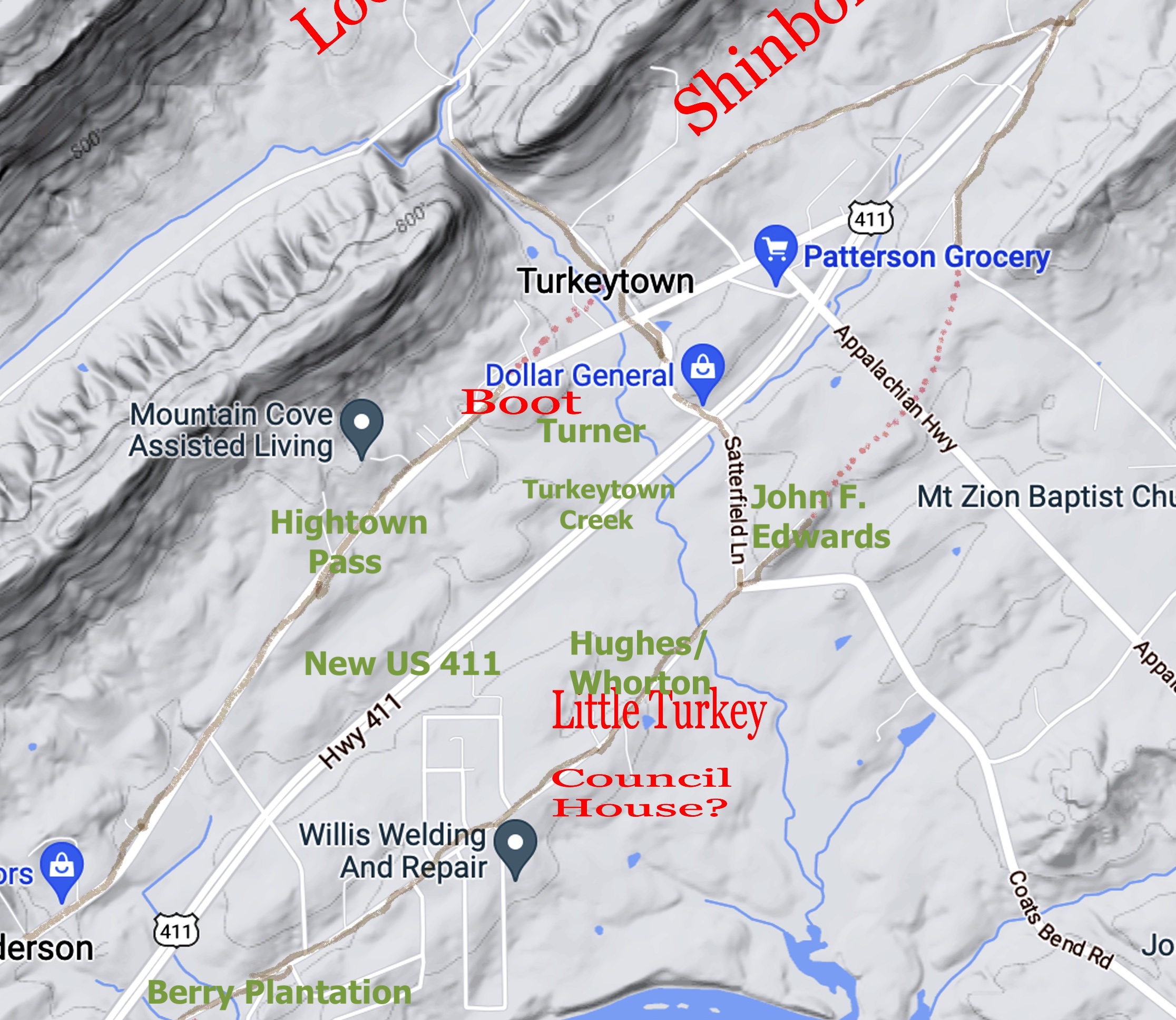
Chulioa (Boot)’s second wife is Wattee. She becomes part owner in a toll bridge over Black Creek on the Hightown Pass. The Pass is the main trade route from Charleston to the West. This route would go through Turkey’s Town to Riley’s Stand. Then it would head North to the Creek Path (Gunnter’s Landing) and finally to the West.
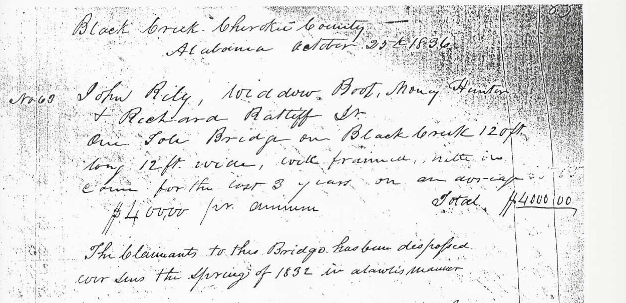
Black Creek Cherokee County Alabama October 25th 1836
No 63. John Riley, Widow Boot, Money Hunter, and Richard Ratliff Jr One Tole Bridge on Black Creek 12 ft long 12 ft wide, rock framed, with income for the last 3 years on an average $400.00 for minimum. Total $4,000.00. The Claimants to the Bridge has been disposed ever since the spring of 1832 in a lawless manner1
There is a lot of information from the Bridge Claim. John Riley is “half blood Cherokee.” Riley owns a stand, which is one of his three farms.2 The stand (trading post) would become a Post Office on 28 January 1833, Double Springs, St. Clair County, Alabama. The Postmaster; William B. Walker.3 This stand is noted in L. V. Beirce’s journal as being 2 miles from Black Creek.4 Bierce notes the Bridge over Black Creek. He does not state whether he paid a toll. Gadsden, Alabama, will have its own post.
Richard Ratliff Jr is married to Chief Pathkiller and Peggy’s daughter Char-wah-yoo-ca. They are listed in Peggy’s Will. (See in the archives, Chief Pathkilller’s family.
Notice the value of the toll bridge. It is $4,000.00. That is over 150k with the inflation added (2025). This is a very well-traveled route. It is not known if they were paid this amount, if any.
Wattee (Widow Boot) lived with her son Turner. Turner’s 1842 claim provides a lot of information as to the location where they lived.
Turner states on oath that all the foregoing property was abandoned by him in 1838 in consequence of having been arrested by the United States Troops in 1838 and owing the strict regulations of the Military, claimant was not permitted to sell or dispose of said property which property thus abandon consisted of all the items as set forth in the account except 1 spotted mare 2 sows 2 Barrows and sheep which property was killed by a white man who had settled close to claimant—said man had no fear of consequence to prevent stock from getting in his field therefore Claimant stock got in said field and the white man though prejudice & ill will, killed said property of claimants this occurred after the laws of Alabama were extended, claimant states also that he cleared one acre of land after the 23 of May 1836-which improvement was not valued by the valuing Agents– Claimant further states that the 2 ½ acres of land taken possession of by a white man named Hughes which land was also never valued by said Agents and he was illegally deposed of the same, claimant states that his orchards of Apples were in full baring & that he believes he was as much intitled to the price of the fruit as the fruit as his corn field, his orchards was large & the fruit of which was worth ($40) forty dollars, Claimant further states he had a note on a man by the name of Lewis Rhea for one hundred & ten dollars given about 18 years ago and Claimant has received as Security times Sixty two dollars from said Rhea and probably would have got the Balance had not the United States Troops forced claimant to immigrate—early before claimant states he has never recovered any of the above property s specified in the forgoing account—nor has he recd any compensation for the above specified property or any part there of from the United States or any other source whatsoever.
Sworn to & Subscribed before me D J Bell Clk March 23 1842 Turner his mark5
Turner stated, “except 1 spotted mare 2 sows 2 Barrows and sheep which property was killed by a white man who had settled close to claimant”. The white man is identified by James Lasley, who was a witness to the claim.
James Lasley States on oath that he knows of a man by the name of Jn Edwards Citizen of the United States who killed the spotted mare belonging there to claimant, also of said Edwards killed 2 hogs belonging to claimant and he claimant never recovered any pay of said Edwards or any other person for said property. Witness further states that he heard Edwards say he would kill more of claimants property and that claimant had more hogs shot by said man afterwards as witness believes, nor has claimant at any subsequent period to the knowledge witness received any compensations from the United States or any other Source for said property. Sworn to & subscribed before me D J Bell Clk March 23rd 1842. James Lasley his mark.6
John F. Edwards is the patent purchaser of the land at Turkeytown Creek. This is at the intersection of Coats Bend Road and Satterfield Lane. 7 Hughes is James A. Hughes Jr, who marries Abraham Whorton’s daughter. (See archives, Location of New Seneca Turkey’s Town). They live a couple of hundred yards south of Turkeytown Creek. Lewis Rhea is Lewis L Rhea. Lewis L. Rhea settled near Bennettsville, Alabama. This was near today’s Attalla, Alabama. Rhea’s daughter and son-in-law are Frances and Thomas Berry. They will build a plantation on Coats Bend Road, a quarter mile south of Turkeytown Creek. Their daughter is Martha Berry of Berry College in Rome, Georgia.8
The Tragedy
Wattee told the Rev. Daniel Butrick about the prophetic coming of Teachers. This is from his journal, which he used to report to the American Board of Commissioners for Foreign Missions.
Sat 19 (January 1822)…..After some conversation his wife an old woman told us that when she was a small child the old people used to say that at some future time period good people would come to instruct them, and that perhaps she & others of her age would live to see the time when the Cherokees would be instructed, and now she thought perhaps we & the other missionaries had come to give them that instruction. 9
In Rev. Butrick’s parallel personal journal, he adds prophetic comments about the removal (Trail of Tears).
The old lady said that when she was a little girl the old men used to say that at some future period teachers would come to the country and instruct them in a great many things, and perhaps it would be when such little girl as she (pointing to her) became old women; an she now began to think the prediction was fulfilled. The poor old woman, however did not [tell] us the whole prediction of the old men, viz. that soon after teachers came they would be driven from their country.10
Turner, in his 1842 Claim, stated that his mother’s death occurred at Fort Payne. It is plausible. She is buried in one of the unmarked graves at the Willstown Mission Cemetery in Fort Payne, Alabama.
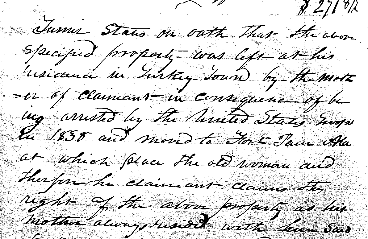
Turner states on oath thus the above specified property was left at his residence in Turkey Town by the mother of Claimant in consequence of being arrested by the United States Troops in 1838 and moved to Fort Pain Ala as which place the old woman died therefore he claimant claims the right of the above property as his mother aways resided with him 11
Their property was sold at Auction. The specific property each owned is unknown. They were taken away by force. Buyers were Wm M Burk, H B Hambrick, L Cunningham, Henry Dunn, John Croft, James Hughes, Wm M. Buck, B D Cook, Jno F. Edwards, Wm Levy, Thos Bullard, Wm Burk, Wm Paterson, Jno Bullard, W M Burke, Wm Lay, H Dunn, J Dobson. TURNER (page 203) – Total Sale $40.00 H Dunn, L Cunningham. 12
Notice the names of the purchasers. John F. Edwards, he killed Turner’s stock. John Croft, is Croft Ferry, which was James Lasley’s ferry.13 William Lay is a person named by James Lasley as having taken his land.14 Lay is the patent purchaser of 159 acres of that property.15 Henry Dunn purchased the land next to James Kay, Peggy Pathkiller’s ferry. James Hughes as mentioned above.
Conclusion
The Cherokees of Turkey’s Town were removed by force June 1838. The Trail of Tears. The Cherokee who lived in the lower Coosa River Valley area were initially taken to Fort Turkeytown. This fort is the one with the fewest records. What is known is that it was on Terrapin Creek.16
There are Military Vouchers for transporting the Cherokee from Fort Turkeytown to Fort Likens and Ross Landing.
There were three stockade forts in Cherokee County in Northeast Alabama. Fort Likens was located in Northern Cherokee County next to “Barry Springs”. Fort Lovell is located where Hwy 35 and 9 intersect today. It is at the Lawrence Cemetery, 3 miles east of Cedar Bluff, Alabama. The site of Fort Turkey’s Town was located on Terrapin Creek, yet to be proven. (The forts of Cherokee County will be their own post later.)
Fort Payne (Dekalb County) was constructed in December 1837 and the Forts in Cherokee County were built by June 1838.
Turner is on Benge Detachment Muster Roll, leaving Fort Payne in September 1838. 2 males aged 15-50, 1 female 15-50, 1 male & 1 female aged 10-15.17 Turner provided one team to the Benge Detachment.18
Turner’s sister, Polly or Widow Boot as listed on the Benge Detachment Muster Roll. Listed; 3 lines above Turner. The group consists of 1 female 15-50, 1 female 10-15, and 1 male <10. No older woman in this group confirms the death of Wattee, widow of the Boot. 19
- NARA RG 75, E224, Vol 25, page 83, Washington DC ↩︎
- John Riley Claim. Tahlequah District Claim #194. Folder 815. John Ross Collection. The Thomas Gilcrease Institute of American History and Art (a/k/a Gilcrease Museum), Tulsa OK. “Curtailment on spoliation Claim for a Ferry on the Coosa River, after passing the Cherokee Committee while setting on Claims at the Cherokee Agency in 1838. Curtailed by the U. States Commissioners.” ↩︎
- US Postmaster Appointments St Clair County, 1832-1971, ancestry.com. ↩︎
- L. V. Bierce; Travels in the South Land 1822-1823, pages 91-93. Copy in the Gadsden Public Library, Gadsden, Alabama ↩︎
- NARA. RG75 E224 Valuations by Rice & McCoy and Rawlings & Massey. #69 Turner. Valued on 29-October-1836 for $747.00. There were 4 houses of differing sizes, 1 stable, 2 corn cribs. They had one 11-acre field and one 2.5-acre fenced lot. They had extensive orchards of peach, apple, cherry, and quince trees. 4th Board Claim, Flint District #3, Claim No. 1, The United States to Turner Residence in the old Nation as Turkey Town now residing in Flint Drist ↩︎
- Ibid ↩︎
- https://glorecords.blm.gov/details/tractbook/default.aspx?volumeID=366&imageID=0022&sid=rrgji0f2.pms#tractBookDetailsTabIndex=1 Bureau of Land Management, Etowah County, Alabama, Township 11, Range 7, Section 10, 159.9 acres. ↩︎
- Family history, copies in possession of this author ↩︎
- Butrick’s Journal, Papers of the American Board of Commissioners for Foreign Missions. 18.3.1 Vol 3. Item 143. Microfilm Reel 738. In Paul Kutsche’s A Guide to Cherokee Documents in the Northeastern United States this is reference #2360. ↩︎
- Butrick’s Journal, Papers of the American Board of Commissioners for Foreign Missions. 18.3.3 Vol 4. Pp 38-39. Microfilm Reel 754. In Paul Kutsche’s A Guide to Cherokee Documents in the Northeastern United States this is reference #4495. ↩︎
- 1842 Flint District Claims Book 3 #5. 23-March-1842. Turner, heir of Wattee Boot, his mother.
↩︎ - National Archives and Records Administration, Washington DC. RG75 E227 Returns of Property. Volume 37 pp 201-203. Watty & Polly & Turner – Total Sale $155.12 ½. ↩︎
- Bureau of Land Management (BLM). John W. Croft, with pre-emption in 1838, purchased 159 acres NW ¼ of section 1 of Township 11 S, Range 7 E. This is on both sides of the Coosa River, which includes the ferry. ↩︎
- 1842 James Lasley Claim, National Archives, Washington DC, Record Group (RG)75 Bureau of Indian Affairs, Entry (E) #224, Volume 25, pages; 96, 97, 99, 100, Copy from Michael Wren’s collection ↩︎
- Bureau of Land Management (BLM), William Lay filed pre-emption in 1838 and purchased the following land; section 35, Township 10 S, Range 7 E; section 36 Township 10 S, Range 7 E, the NW ¼ 159 acres. ↩︎
- National Archives and Records Administration, Washington DC. Record Group 217, Entry 712.
See also Turner’s 1842 Flint District Claims Book 3 #1. Witness George Augerhole said he was arrested by the troops the same day and forced off to Ross Landing. See also U.S. Supreme Court Case Erby Boyd, Plaintiff in Error, vs. William Scott and William Green. The case involved title to land claimed as a Creek Indian Reserve of his mother-in-law. “The proof showed that Augerhole remained in the country until the summer of 1838, when he was taken west by the troops of the U.S. with the Cherokee tribe; the Creek tribe having been removed in the years 1836 and 1837. There was no proof as to the manner in which Augerhole was first taken by the troops, but there was proof showing that after he was taken, he together with about 500 Cherokees, were kept by the troops at Fort Larkins[sic] in the State of Georgia [sic] and there put under guard and so kept until they were transported by the troops to Ross Landing, in the State of Tennessee, and thence to the west of the Mississippi.” ↩︎ - Muster Roll of the Detachment led by John Benge. John Ross Papers, Folder #504. Helmerich Center for American Research, Gilcrease Museum, Tulsa Oklahoma. ↩︎
- Names of People who Provided Services to the Detachments. Detachment #4. John Ross Papers, Folder #912, Helmerich Center for American Research, Gilcrease Museum, Tulsa Oklahoma. ↩︎
- Muster Roll of the Detachment led by John Benge. John Ross Papers, Folder #504. Helmerich Center for American Research, Gilcrease Museum, Tulsa Oklahoma. ↩︎
Trust in the Lord with all your heart, and do not rely on your own understanding; in all your ways know him, and he will make your paths straight. Proverbs 3: 5-6 CSV
