
Tags
alabama-history, cherokee-indians, Etowah County Alabama History, Gadsden Alabama, John Riley, northeast-alabama-history, trail-of-tears
We continue to uncover the history of John Riley. He is a notable person of Turkey’s Town. We explore his ferry and its connections to Gadsden, Alabama.
Our best research on this ferry is found in a report to the National Trail of Tears Association, 2009. Alabama Collection Camps, Forts, Emigrating Depots and Travel Routes Used During the Cherokee Removal of 1838-1839 1
Chapter Eight is about the ferries in Northeast Alabama on the rivers and streams. “Topography of the Removal Routes”, written by Mike Wren. Riley’s ferry/Walker’s ferry begins on page 251.
COOSA RIVER #9
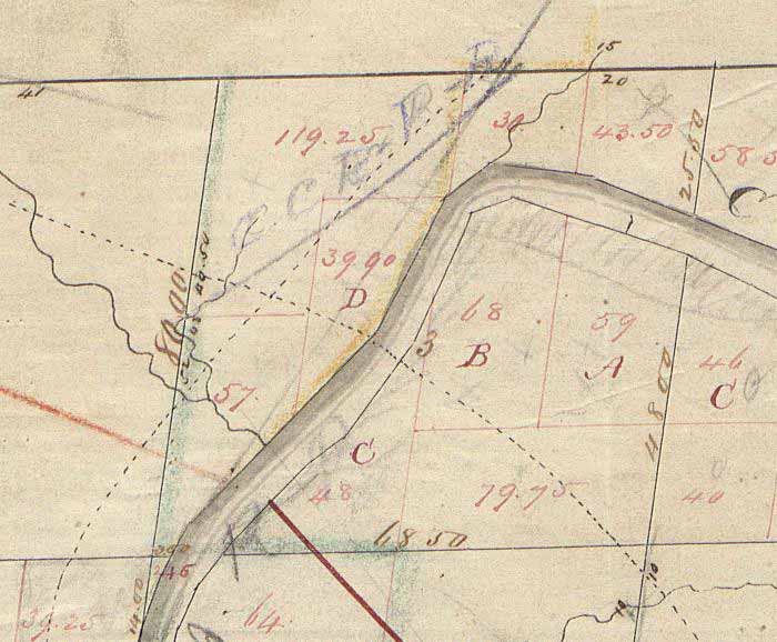
Township 12 South, Range 6 East, Section 3
John Riley’s Ferry / Walker’s Ferry
A Road called the Jacksonville Road crossed the Coosa River at this point. John Riley owned a Ferry on the Coosa River in what was described as Turkey Town Valley in Cherokee County.80 3Riley’s Ferry was the second most valuable on the Coosa River.
John Riley filed a claim for $3,000 for dispossession of his ferry on the Coosa River opposite the Double Springs by William B. Walker, a white man. Silas Choate confirmed his statement. It is interesting that W. B. Walker also confirmed Riley’s statements. The Claim was not allowed apparently because it had already been valued.81 4Riley also filed a claim on February 12, 1838 for spoliation of 6 years of rent from 1832.825In 1842, Riley petitioned for reimbursement of the aforementioned ferry rent of $1,450 and also for $112 for a “Note of Hand Executed to Richard Riley on the 10th day of August 1821 by H. Walker and Robert Walker, citizens of the U. States…”83 6On March 16, 1842 Mrs. Susannah Riley also filed a claim that included “Fifty dollars, note of hand on William Walker, citizen of the U. States, Executed in the year 1835, prevented from collection by her Removal West and Interest on the same for seven years, Alabama Inst.”84 7
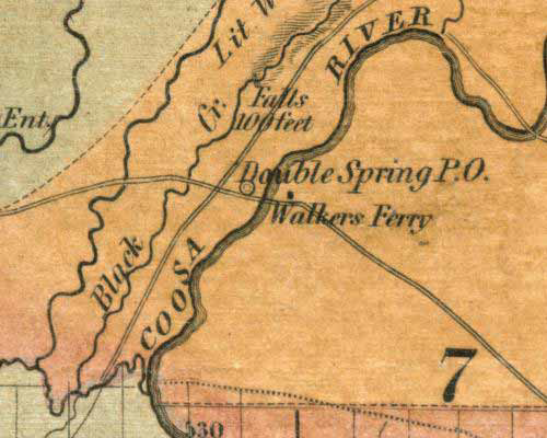
On LaTourette’s 1837 Map, the Ferry at the Double Springs Post Office is identified as Walkers Ferry. Double Springs is the present location of the City of Gadsden Alabama. The Jacksonville Road that crossed the Coosa River at Walker’s Ferry would today be U.S. Highway 431. There were no Walkers among the Original Patentees in Section 3.86 9Claim #958 in the Records of the 4th Board made by the Heirs of John Riley vs. US was for loss of a ferry from 1807 to 1819.87 10This likely refers to a different ferry.
Mike does not tell us how this connects to Gadsden, Alabama, in the report. Notice on LaTourette’s map: Walkers Ferry is plotted on the east side of the river. William B. Walker lived on the east side of the river. William B. Walker is listed as the Postmaster in 1833 for Double Springs. John Riley is still living here at that time in Turkey’s Town. Who established the Post Office? Postal records have not been found telling us who established the PO.
What Happened to William B. Walker?
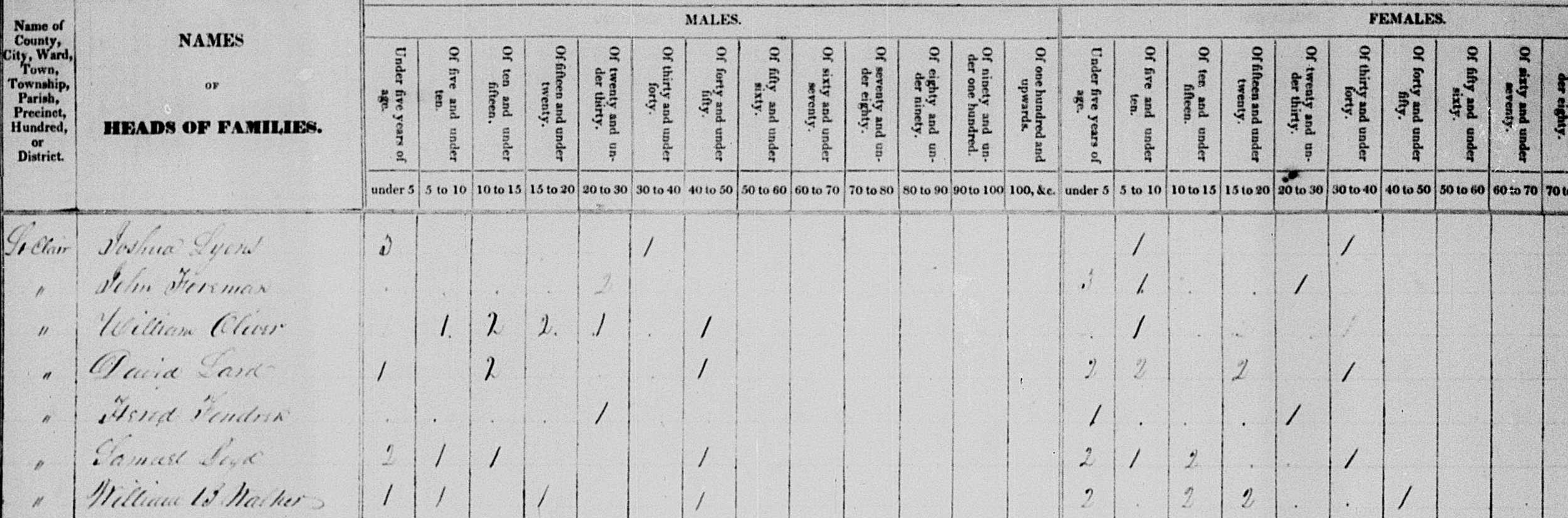
William B. Walker is listed on the 1830 US Census Record in Saint Clair County. He has a family. Where did they go?
He is not on the 1840 census for Saint Clair County or Cherokee County, Alabama. Did they move off or did he die and his family move? The answers are unknown. Walker was the Postmaster for Double Springs, Alabama, as noted. He was paid $16.37 in September 1839 as the postmaster at Double Springs, Alabama.11 After the payment for the postmaster in 1839, all records of William B. Walker were lost or disappeared.
Ferry
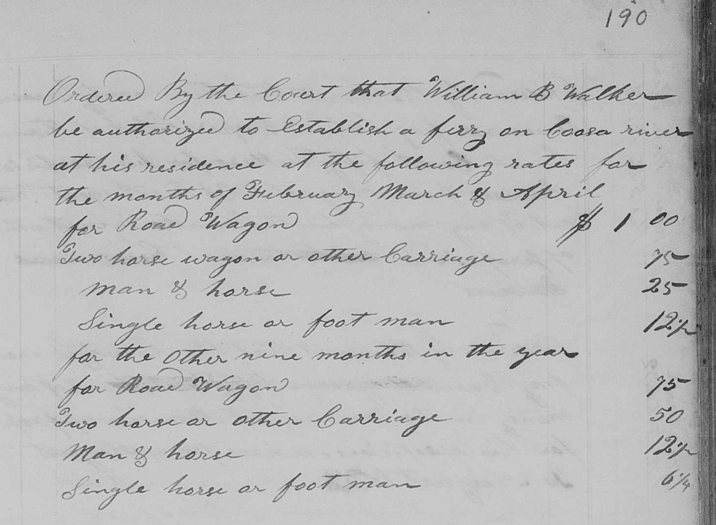
Riley’s ferry will be called Walker’s Ferry by the early settlers. It shows up in the Saint Clair County records. The court minutes show who is in charge of the postal routes. They also show the authorization and fees for ferries. On page 203; “It is odrdered by the Court that Nathaniel Davis be appointed overseer of the road from William Walker’s ferry to the Benton County line. Road 2 grade.“12
You can read the record of the ferry as Walker’s Ferry. It list the fees. This was recorded in 1832.
It will become Hampton’s Ferry then Ewing’s Ferry. The ferry landing and John Riley’s house will become the hub or center point for establishing a town. This town will be called Gadsden, Alabama.
Homestead
The 1928 Woman’s Club’s book records information about the beginning of Gadsden. This section was written by Mary E. Hughes (wife of Joseph R. Hughes, son of Gabriel). It was written in 1884 as the Woman’s Club noted.
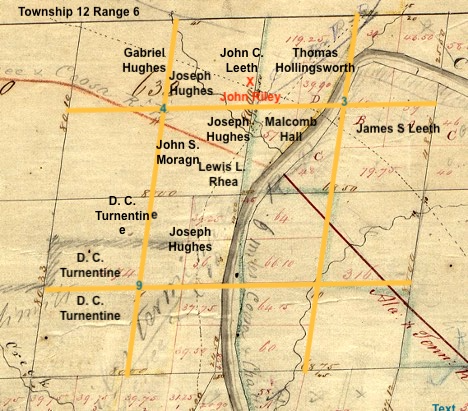
In 1844 these three men field entry to the Government for the land grants and received the patents in 1845. John S. Moragne entered sixty acres, Joseph Hughes entered twenty acres, and Lewis L. Rhea entered forty acres, which he sold to Joseph Hughes July 14, 1846. On these 120 acres the original survey of Gadsden was made. Page 15-16
The Steam boat landing was finally located at the foot of Broad street after much contention as other parties wanted it at Hampton’s (now Ewing’s) ferry. Having gained the victory, Messrs. Gabriel and Joseph Hughes and John S. Moragne laid off the town on their land in 1846 and deeded Captain Lafferty who located the land for them, a number of lots. They met one day by appointment to name their embryo city, at a building near the river not far from Barrett residence now stands and once decided to call the place Lafferty-and Lafferty it surely would have been but for the opposition of the Captain himself, who had met with them. . . they decited to name their town after the hero of the hour, General Gadsden. . . . Page 1814
Here is a listing of the patent purchasers who homesteaded the property that would become Gadsden, Alabama, in the 1840s. You can see Joseph Hughes, John S. Morgan, and Lewis L. Rhea in the center.
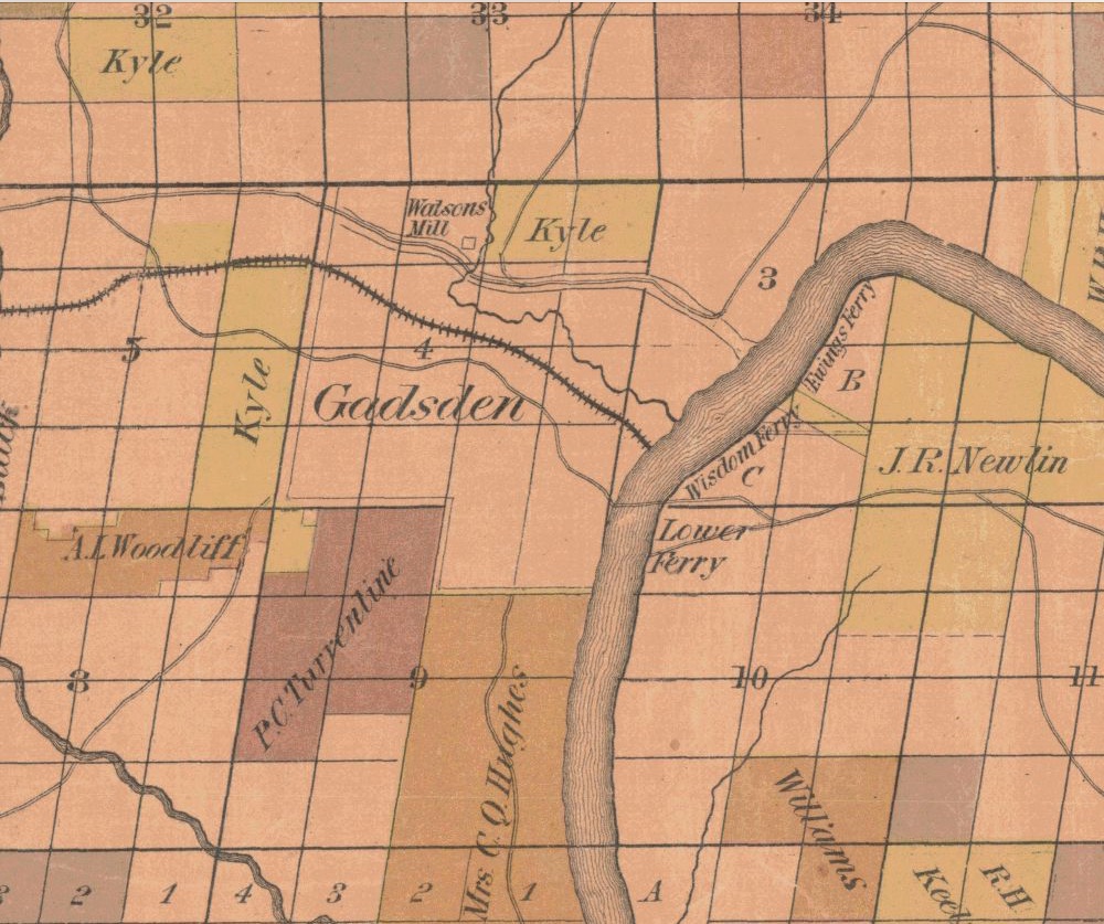
One last image of what would become Gadsden is the first map of Etowah County. Tallman drew it and it was published in 1877. The image comes from the University of Alabama’s website on Historic Maps of Etowah County, Alabama. You can see Ewing’s Ferry, the original Riley’s Ferry. You can see Wisdom’s Ferry, which is the Lafferty Landing and the ferry they created for it in 1846. Then there is the lower ferry, which is unnamed. You can see the location that is plotted out for Gadsden.
John Riley is a notable person of Turkey’s Town. His farm and ferry led to the establishment of Gadsden, Alabama.
- https://nationaltota.com/alabama-forts-and-camps/ ↩︎
- 79. Survey of Township 12 South of Range 6 East, of the Huntsville (AL) Meridian, fraction north of Wills Creek and the Old Cherokee Boundary Line. Plat certified June 10, 1840 by James W. Weakley, Surveyor General of the public lands in Alabama. Jonathan M. Cunningham, Deputy Surveyor.
http://www.glorecords.blm.gov/SurveySearch/
↩︎ - 80. Rice and McCoy/Rawlings and Massey’s Valuations, Cherokee County, Alabama, #62; Property Valuations, Entry 224; Records of the Bureau of Indian Affairs, Record Group 75; National Archives Building, Washington, DC. The Ferry was included within Riley’s entire Valuation. It simply noted “One Ferry on Coosa River, nette income on an avridge for the last 3 years $815.00. Amount allowed $8,150.00.” ↩︎
- 81 John Riley’s Claim dated December 17, 1836. Folder of John Riley; Miscellaneous Claims Papers, 1836-1839, of the First Board of Cherokee Commissioners, Entry 236; Records of the Bureau of Indian Affairs, Record Group 75; National Archives Building, Washington DC. The Folder of also contains an affidavit dated October 7, 1837 from George W. Walker affirming Riley’s Claim. It is not known what George Walker’s relationship was to William B. Walker. The Folder also contains a statement from Hezekiah Oden dated December 11, 1837 that refers to Walker as Capt. William B. Walker. See also St Clair County Court Minutes Book (1828-1834) page 190 where during the August 1832 Term it is recorded “Ordered by the Court that William B. Walker be authorized to Establish a ferry on Coosa river at his residence at the following rates….” ↩︎
- 82 Ibid. Riley wrote a letter to General Nathaniel Smith on Feb 14 about the loss of the rent. Commissioner Kennedy issued his opinion on May 7, 1838 disallowing any payment for loss of income. ↩︎
- 83 John Riley Claim. Tahlequah District Claim #194. Folder 815. John Ross Collection. The Thomas Gilcrease Institute of American History and Art (a/k/a Gilcrease Museum), Tulsa OK. “Curtailment on spoliation Claim for a Ferry on the Coosa River, after passing the Cherokee Committee while setting on Claims at the Cherokee Agency in 1838. Curtailed by the U. States Commissioners.” ↩︎
- 84 Susannah Riley Claim. Tahlequah District Claim #167. Folder 808. John Ross Collection. The Thomas Gilcrease Institute of American History and Art (a/k/a Gilcrease Museum), Tulsa OK.
John Riley’s wife, Susannah, was white and her maiden name was Walker. It is not known if there was any familial relationship between her and any of these white men named Walker. ↩︎ - 85 John LaTourette, An Accurate Map of the State of Alabama and West Florida, NY: Colton & Co., 1837. http://alabamamaps.ua.edu/historicalmaps/alabama/1825-1850.html, Sheet 2 covers Cherokee, DeKalb and Jackson Counties.
Specifically see http://cartweb.geography.ua.edu:9001/StyleServer/calcrgn?cat=North%20America%20and%20United%20States&item=States/ Alabama/LatouretteSheet02.sid&wid=500&hei=400&props=item(Name,Description),cat(Name,Description)&style=simple/vie w-dhtml.xsl# ↩︎ - 86. Bureau of Land Management, General Land Office Records, Eastern States Office, Springfield, VA. Pre-emption Certificate #6,072 for James S. Leeth of Cherokee County Alabama issued May 1, 1845 for fractions “A” and “B” of fractional Section 3 in Township 12 of Range 6 East. Pre-emption Certificate #6,359 for William Boyd of Benton County Alabama issued May 1, 1846 for fraction “C” and the south part of the southeast quarter of fractional Section 3 of Township 12 in Range 6. Pre-emption Certificate #6,811 for William Tillison and Francis M. Tillison, assignees of Thomas Hollingsworth (as tenants in common) issued June 1, 1845 for the northwest fractional quarter and the fraction “D” of fractional Section 3 in the fractional Township 12 of Range 6 East. All in the District of Lands subject to Sale at Lebanon Alabama. http://www.glorecords.blm.gov/PatentSearch/ ↩︎
- 87 Claim #958 (Heirs of John Riley vs. the United States) is not extant; Claims Papers, 1846-1847, of the Fourth Board of Cherokee Commissioners, Entry 250; Records of the Bureau of Indian Affairs, Record Group 75; National Archives Building, Washington DC. See Fourth Board Minute Docket 2 page 71; Minutes of the Fourth Board of Cherokee Commissioners, Entry 249; Records of the Bureau of Indian Affairs, Record Group 75; National Archives Building, Washington, DC. ↩︎
- images, FamilySearch (https://www.familysearch.org/ark:/61903/3:1:3Q9M-CS8GP9R6-
F?view=fullT ext : Jan 27, 2026), image 1917 of 1990; https://www.familysearch.org/ark:/61903/3:1:3Q9M-CS8G-P9R6-F?view=fullText
↩︎ - St Clair County Court Minutes Book (1828-1834) page 203, FamilySearch.com https://www.familysearch.org/ark:/61903/3:1:3Q9M-CS42-K93K-S?view=fullText&keywords=William%20Walker%2CWilliam%2CWalker%2Cferry&lang=en&groupId= ↩︎
- St Clair County Court Minutes Book (1828-1834) page 190, https://www.familysearch.org/ark:/61903/3:1:3Q9M-CS42-K93L-T?view=fullText&keywords=William%20Walker%2CWilliam%2CWalker%2Cferry&lang=en&groupId= ↩︎
- A Little Book About Gadsden, Alabama. Written and Published by the Department of Archives and History of the Woman’s Club of Gadsden, 1938. Page 14-15, 18 , Gadsden Public Library, Gadsden, Alabama. ↩︎
- Survey of Township 12 South of Range 6 East, of the Huntsville (AL) Meridian, fraction north of Wills Creek and the Old Cherokee Boundary Line. Plat certified June 10, 1840 by James W. Weakley, Surveyor General of the public lands in Alabama. Jonathan M. Cunningham, Deputy Surveyor.
http://www.glorecords.blm.gov/SurveySearch/ Lables add by the writer. ↩︎ - http://cartweb.geography.ua.edu/lizardtech/iserv/calcrgn?cat=North%20America%20and%20United%20States&item=States/Alabama/Counties/etowah//Etowah1877a.sid&wid=1000&hei=900&props=item(Name,Description),cat(Name,Description)&style=simple/view-dhtml.xsl ↩︎
Trust in the Lord with all your heart, and do not rely on your own understanding; in all your ways know him, and he will make your paths straight. Proverbs 3: 5-6 CSV
