• Home
  • About
  • Alabama Chapter Trail of Tears Association
  • National Trail of Tears Association
  • Local History

New Seneca Turkey's Town

~ Uncovering the History of Turkeystown, a Cherokee Village/Town in Northeast Alabama

New Seneca Turkey's Town

Monthly Archives: March 2026

Chapter IV Trail of Tears

19 Thursday Mar 2026

Posted by Jeffrey Sauls in Local History

≈ Leave a comment

Tags

alabama-history, cherokee-indians, Etowah County Alabama History, northeast-alabama-history, trail-of-tears, turkeytown

Turkey’s Town and the Trail of Tears. A dark history of the US. How did this affect Turkey’s Town? How were the people involved?

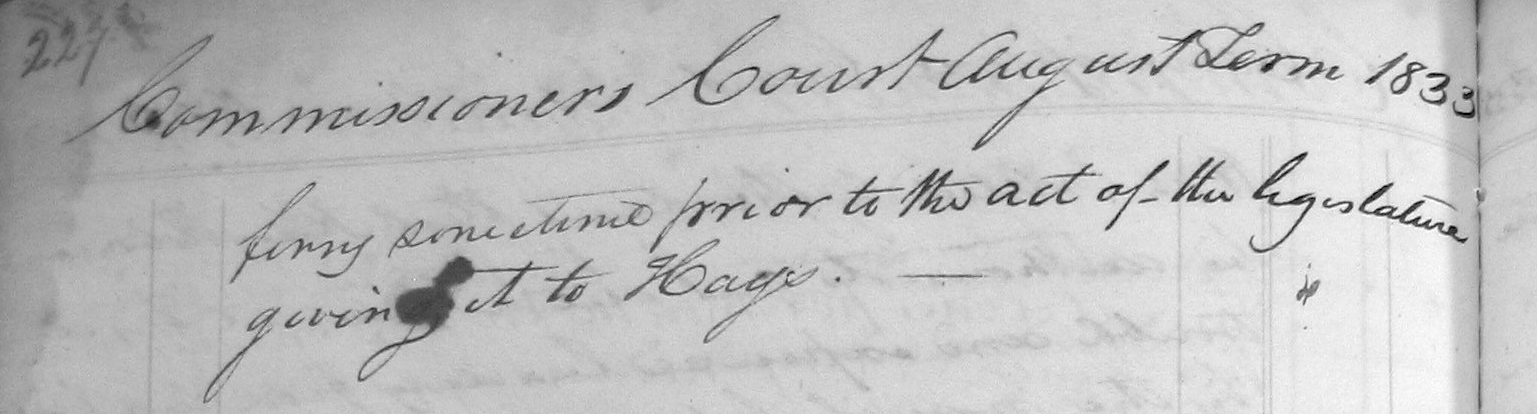
Turkey’s Town’s involvement was first seen in the Treaty Ratification of October 1816.

Turkey Town Treaty

At midnight on 4 October 1816, Andrew Jackson and David Meriwether dictated a letter to be sent to William H. Crawford, Secretary of War with a summation of the treaty and other comments. In this letter at image 113, they talked about the removal West of the Mississippi. Several Chiefs inquired about the effects on the nation.

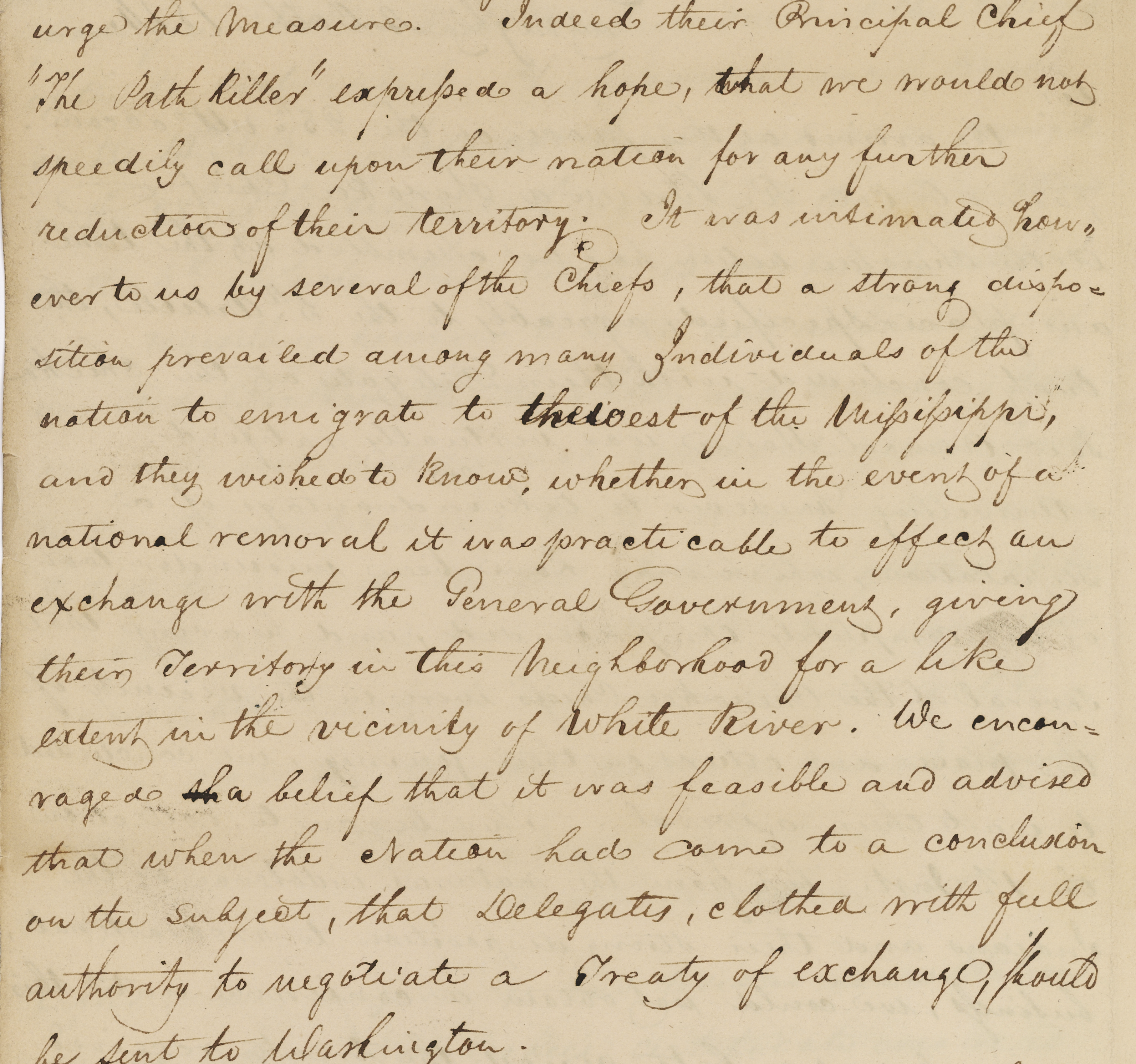
 It was internalize to us however several of the chiefs that a strong disposition prevailed among many individuals of the nation to emigrate to the west of the Mississippi and they wished to know whether in the event of national removal it was practicable to effect an exchange with the General Government. .1

The Removal Bill

Americans elected Andrew Jackson of Tennessee as president in 1829. The Removal Bill of 1830 initiated the voluntary Indian removal. It was also known as the Indian Removal Act. The Indian Removal Act was passed in May 1830. It provided for lands in the Arkansas territory as a place to move to. So-called “West of the Mississippi River”. 2

Chief John Ross, Principal Chief of the Cherokee Nation, protested. The State of Georgia passed a bill in January 1830, claiming all of Northwest Georgia and the Cherokee Territory. This included Georgia State laws over the land.3 To add to the takeover of land, gold was found in Northwest Georgia. White men intruded by the hundreds searching for gold. 4 Georgia then sectioned off the land, and a lottery was held for 160-acre lots.

New Echota Treaty 1835

The Treaty of New Echota was signed on December 29, 1835, in New Echota, Georgia. Officials of the United States government and representatives of a minority Cherokee political faction, the Treaty Party, were involved.

The treaty set terms for the Cherokee Nation to give up its territory in the southeast. They were to move west to the Indian Territory. The treaty was not approved by the Cherokee National Council. Principal Chief John Ross did not sign it. Still, it was amended and ratified in March 1836 by the US Congress by one vote. This amendment and ratification made it the legal basis for the forcible removal. 5

The twenty-member council, “Treaty Party” that signed (by mark or signature).

Major Ridge,   Te-gah-e-ske,  James Foster,   Robert Rogers,  Tesa-ta-esky,  

John Gunter,  Charles Moore,  John A. Bell, George Chambers,  Charles F. Foreman, Tah-yeske,  

William Rogers, Archilla Smith, George W. Adair, Andrew Ross,  Elias Boudinot, 

William Lassley,  James Starr, Cae-te-hee,  Jesse Half-breed, 

Stand Watie, John Ridge. were the ones who provided instructions. 6

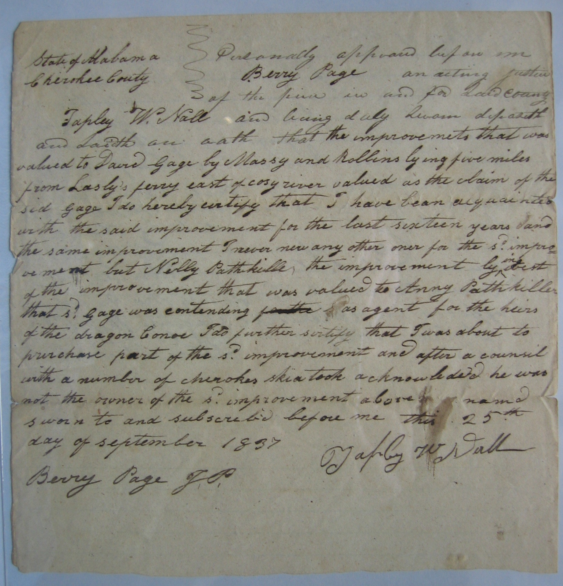
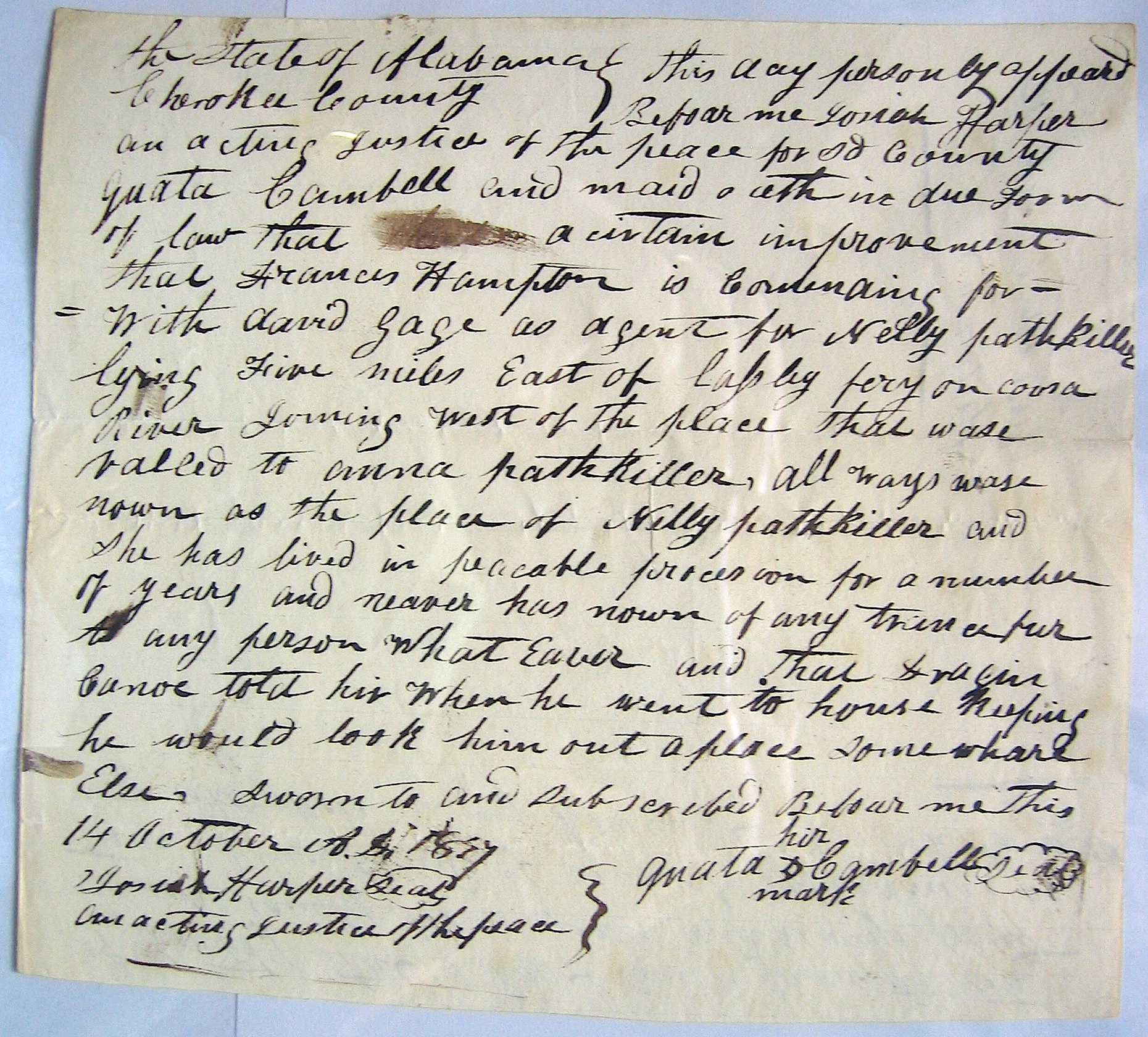
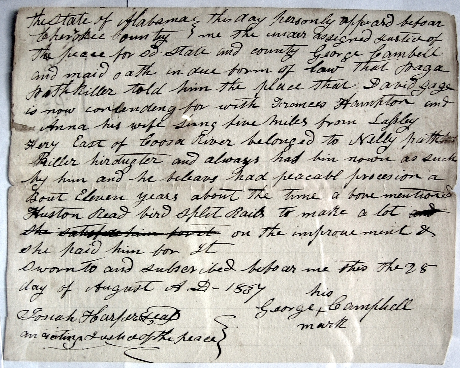
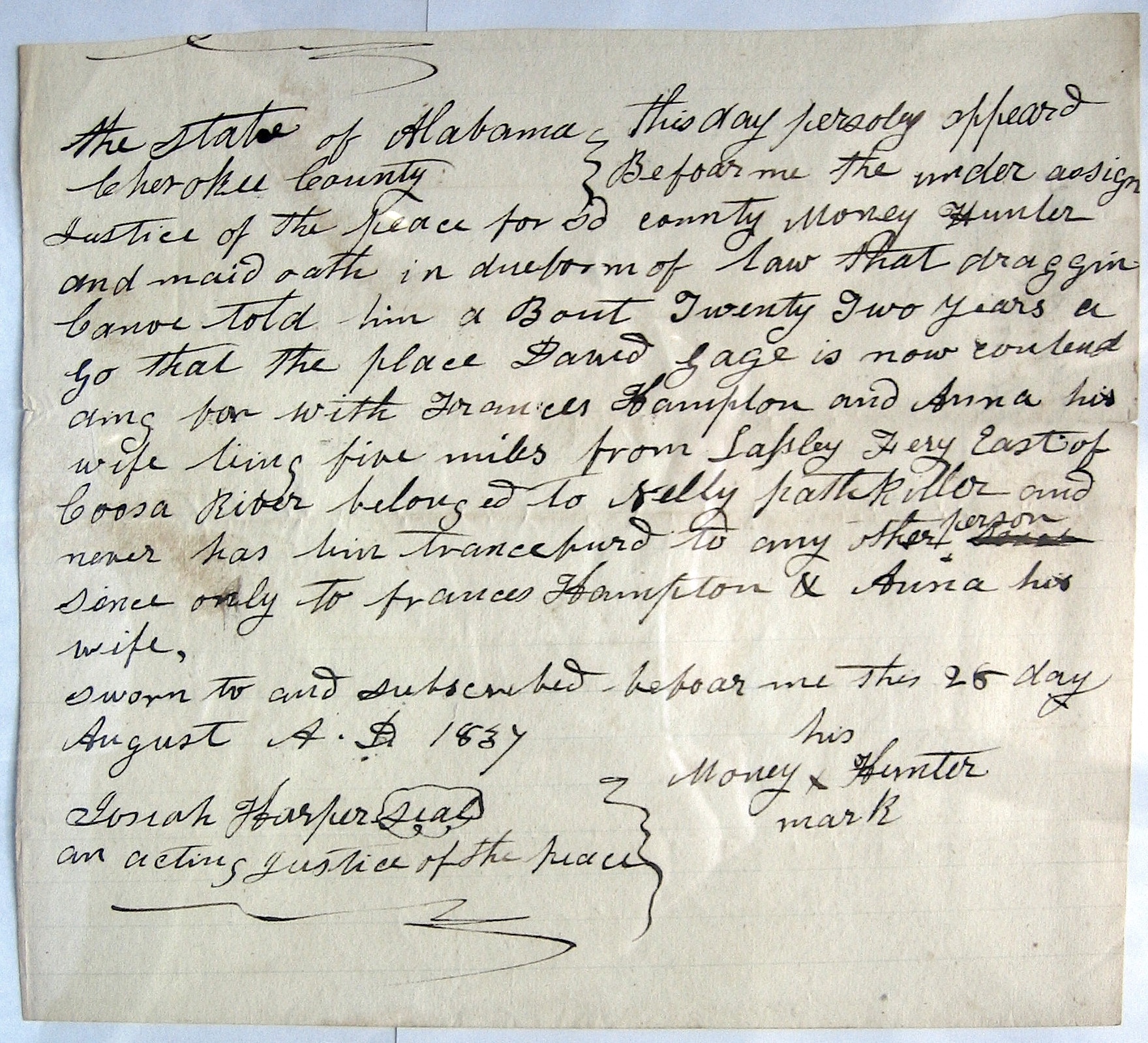
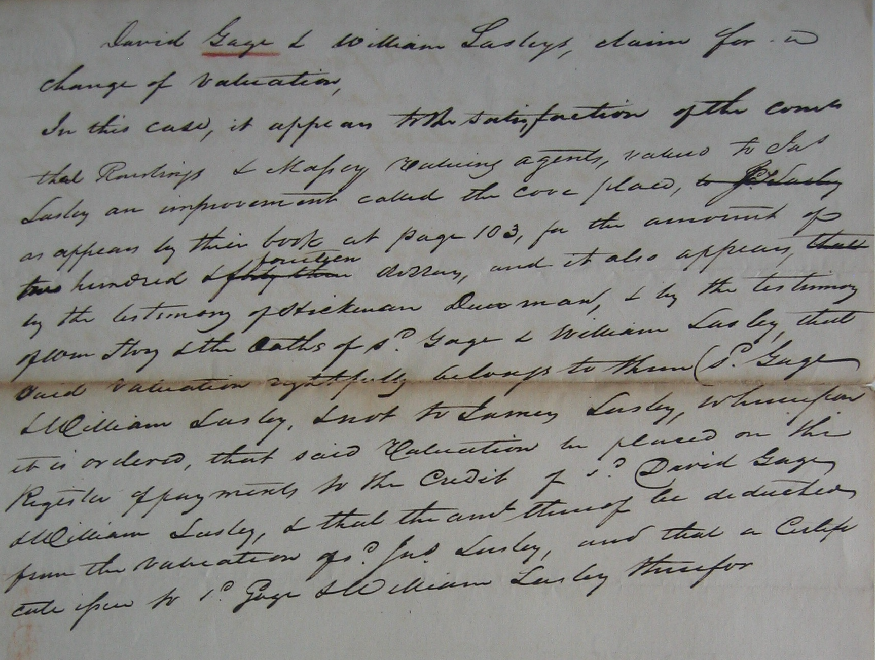
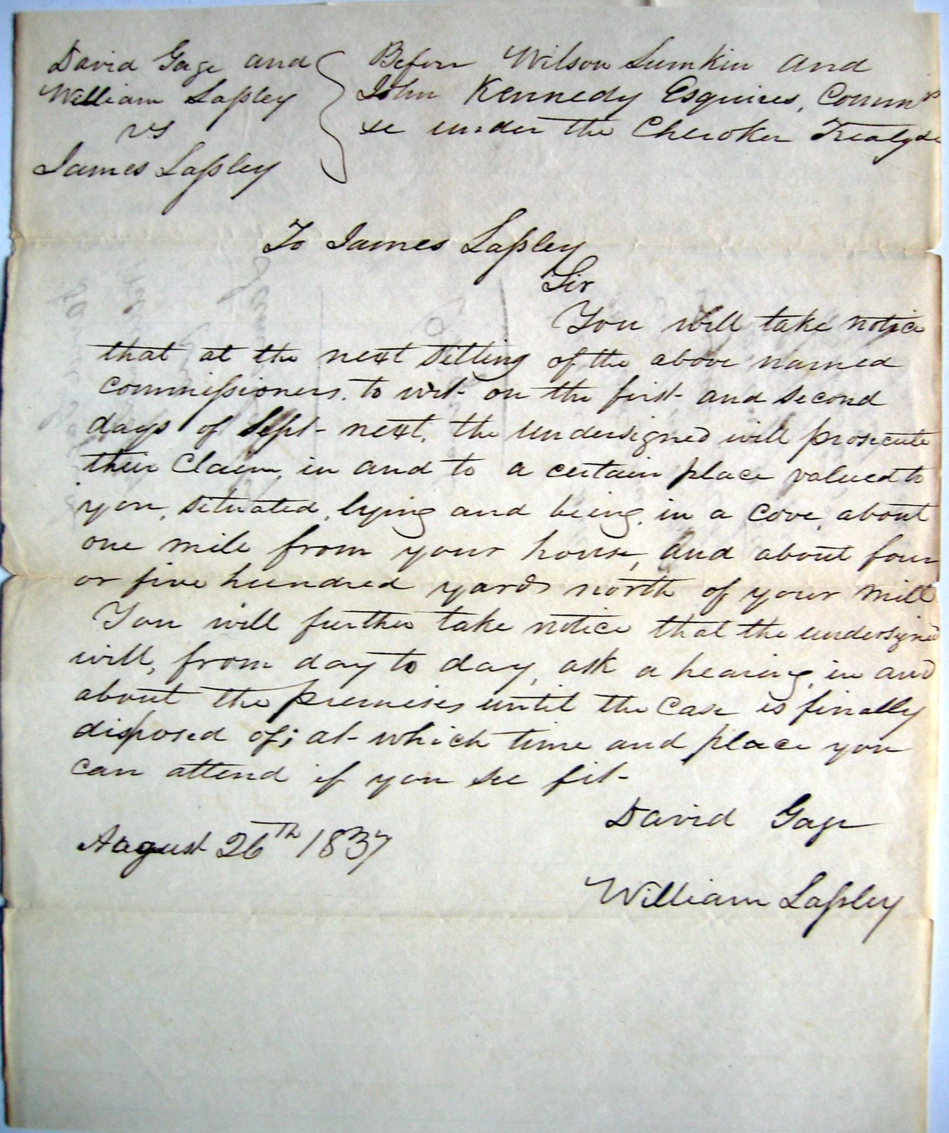
John Ridge, with this group, held 3/8 interest of Chief Pathkiller’s estate. This included the ferry, house and orchards at what is today’s Centre, Alabama. Review Chief Pathkiller’s ferries in this blog. John Ridge was the National Council’s Clerk (Secretary). William Lassley is the son of James Lasley. He is mentioned in the posts on James Lasley.

1835 Census

To know who would be potentially removed from Turkey’s Town, we need to review the 1835 census. A census was ordered to be taken of all Cherokees left in Alabama, Georgia, and Tennessee. This refers to the Henderson Roll. Below are the heads of households from Turkey’s Town. Rezin Rawlings took the census in Alabama. Recorded October 26, 1835. 7

page 15

N. Pathkiller, SE NO WAY, Writer, Nann, TE SEE, Johnson, Seeds, AT TA WO NO LE SKE, CHU WA STE TA, AH TA LO NE, Dirt Seller, Buffalo,

page 16

John E WAY NAH, SOR KE NEE, SE QUA TAH, TEN A YA CHEE, TA KEE, CHU QUA LOO KEE, Richard Ratliff Jr., George, Richard Ratliff Sr., James Lassley, Gun Fill, Pumpkin Pile, TU NE WAH, TOO NEY, Young Wolf,

page 17

Money Cryer, WAT TEE, James Carroll, John Ratliff, George Campbell, TE LU NA SKEE, Corn Tassel, Beaver Tail, John Riley, A NEY, Nelly, Auger Hole (Coosa),

Next Time

Who is on the detachment rosters? The Cherokee in Turkey’s Town were rounded up and forced to the stockade at Fort Payne. During June and July of 1838, they were forced from their homes.

  1. Image 113, National Archives, Record Group 11, General Records of the United States Government, Series Indian Treaties; RIT #83; Ratified Indian Treaty #83, Cherokee, Chickasaw Council House September 14, 1816, There are 231 images of this with correspondence of letters and a journal. https://catalog.archives.gov/id/100220646 ↩︎
  2. Indian Removal Act: Primary Documents in American History. Library of Congress. https://guides.loc.gov/indian-removal-act ↩︎
  3. John Ross and the Cherokee Indians, Rachel Caroline Eaton, A. M. 1914, Chapter VII, The Removal Bill, Image 60,Google Books, https://play.google.com/books/reader?id=0eUNAAAAIAAJ&pg=GBS.PA60 ↩︎
  4. Ibid, Image 64 ↩︎
  5. The Treaty of New Echota, https://en.wikipedia.org/wiki/Treaty_of_New_Echota ↩︎
  6. Laws and Treaties, Volume II, Charles J. Kapplar, Treaty with the Cherokee 1835, https://americanindian.si.edu/nationtonation/pdf/Treaty-of-New-Echota-1835.pdf ↩︎
  7. Cherokee Indian census of 1835 of the states of Georgia, Alabama, and North Carolina. Copy of the transcribed Alabama Section of the Old Book. Personal Copy of Jeffrey Sauls, received as a gift in 1992. ↩︎

Trust in the Lord with all your heart, and do not rely on your own understanding; in all your ways know him, and he will make your paths straight. Proverbs 3: 5-6 CSV

David A Gage, Notable People

03 Tuesday Mar 2026

Posted by Jeffrey Sauls in Local History

≈ Leave a comment

Tags

alabama-history, cherokee-indians, Chief Pathkiller, Etowah County Alabama History, northeast-alabama-history, trail-of-tears, turkeytown

As we continue with David Gage in Turkey’s Town, we see that he is involved with Tarpley W. Nall. Tarpley W. Nall was trying to buy a part of Nelly’s farm. This farm is on the East side of the Coosa River. Modern-day Alford’s Bend. Review the previous documents. All of this property was Chief Pathkiller’s until he and his wife, Peggy, separated (divorced). Peggy has gifted the improvements to her daughter, Nelly. Nelly has gifted them to her daughter Anna. Dragging Canoe (deceased), Chief Pathkiller, and Peggy’s son’s family are claiming it along with David Gage. Confusing? Sky-a-too-ka, the son of Dragging Canoe, has enlisted David Gage on their part. Tarpley Nall decided not to buy after speaking with some Cherokee. He also said Sky-a-too-ka said he is not the owner. Tarpley W. Nall is a white man not married.

1

Quata, Peggy and Chief Pathkiller’s daughter sided with Anna on who owned the improvements.

2

Quata is married to George Campbell. George is a white man. They are listed in Peggy Pathkiller’s will. Anna is married to Frances Hampton.

3
4

Money Hunter is a nearby neighbor.

David Gage and William Lasley

David Gage is involved with William Lasley. William is the son of James and Elizabeth Lasley. Elizabeth is Elizabeth Wicket, a Cherokee woman. James and Elizabeth separated in 1822 when Elizabeth wanted Big Cabin as a husband. You can review this in the section on James Lasley. The following document is where William Lasley is try to buy an improvement next to his father. The location of this is about four miles north of modern-day Turkeytown Creek. It would be on Spring Avenue. This is near modern-day Croft Ferry. Croft Ferry is James Lasley’s Ferry.

5
6

David Gage, Pathkiller’s Original Ferry

David Gage assisted James Kay in acquiring Chief Pathkiller’s original ferry. When Chief Pathkiller and Peggy separated Chief Pathkiller moved north and “took” a new wife. He started the improvements that would become Pathkiller’s Ferry, modern-day Garrett’s Ferry, Centre, Alabama. Peggy was left with the original ferry and improvements. This was one-and-a-half miles south of Turkeytown Creek. This is modern-day Fitts Ferry. This separates Alford’s Bend on the east side from White’s Chapel/Gaston School area on the west side.

John Ratliff filed a Claim for this ferry on January 16, 1837 (he was one of four owners). He filed it before Josiah Harper, Acting Justice of the Peace for Cherokee County, Alabama. He stated that the Ferry was 1½ miles below Turkeytown and was then in the possession of James Kay. He said that a white man named Hays took the ferry from him. This happened shortly after the laws of Alabama were extended over the Cherokee lands in January 1832.7

8
9
10

The Original Patentee for the ferry’s location was James Kay. He homesteaded the west side of the ferry.11

Conclusion

David Gage, a notable person of Turkey’s Town. He and his family moved west during the Trail of Tears. They moved on their own. They are not listed on a detachment roll for the Trail of Tears. They settled in Texas.

He was elected the first Constable of Turkey Town, Alabama.

Also confirmed in these documents is that Turkey’s Town is in modern-day Etowah County. All of the documents state, “five miles below Lasley”. Alford’s Bend and Croft Ferry are in Etowah County, modern-day.

  1. NARA, Record Group 75, Entry 236, Miscellaneous Claims Papers, 1836-1839, Records of the Bureau of Indian Affairs, Image 449, National Archives Building, Washington, DC ↩︎
  2. Ditto, Image 580 ↩︎
  3. Ditto, Image 582 ↩︎
  4. Ditto, Image 590 ↩︎
  5. Ditto, Image 439 ↩︎
  6. Ditto, Image 443 ↩︎
  7. John Ratliff’s Spoliation Claim for a Ferry and Improvement. Folder of John Ratliff; Miscellaneous Claims Papers, 1836-1839, of the First Board of Cherokee Commissioners, Entry 236; Records of the Bureau of Indian Affairs, Record Group 75; National Archives Building, Washington DC.  ↩︎
  8. St. Clair (AL) County Court Minutes (1828-1834), March-August, 1833 page 172 ↩︎
  9. Ditto, page 226 ↩︎
  10. Ditto, page 227 ↩︎
  11. Bureau of Land Management, General Land Office Records, Eastern States Office, Springfield, VA. Pre-emption Certificate #6,885 for James Kay of Cherokee County Alabama issued June 1, 1845 for fraction “A” of fractional Section 20 in Township 11 of Range 7 East. Pre-emption Certificate #8,419 for James Kay of Cherokee County Alabama was issued April 10, 1847 for the northwest quarter of the southwest quarter of Section 20 in Township 11 of Range 7 East. Both in the District of Lands subject to Sale at Lebanon Alabama. http://www.glorecords.blm.gov/PatentSearch/ ↩︎

Trust in the Lord with all your heart, and do not rely on your own understanding; in all your ways know him, and he will make your paths straight. Proverbs 3: 5-6 CSV

Subscribe

  • Entries (RSS)
  • Comments (RSS)

Archives

  • March 2026
  • February 2026
  • January 2026
  • December 2025
  • November 2025
  • October 2025
  • September 2025
  • August 2025
  • July 2025
  • June 2025
  • May 2025
  • April 2025
  • March 2025
  • February 2025
  • January 2025
  • December 2024

Categories

  • Local History

Meta

  • Create account
  • Log in

Website Built with WordPress.com.

  • Subscribe Subscribed
    • New Seneca Turkey's Town
    • Already have a WordPress.com account? Log in now.
    • New Seneca Turkey's Town
    • Subscribe Subscribed
    • Sign up
    • Log in
    • Report this content
    • View site in Reader
    • Manage subscriptions
    • Collapse this bar
 

Loading Comments...