Turkey’s Town and the Trail of Tears. A dark history of the US. How did this affect Turkey’s Town? How were the people involved?
Turkey’s Town’s involvement was first seen in the Treaty Ratification of October 1816.
Turkey Town Treaty
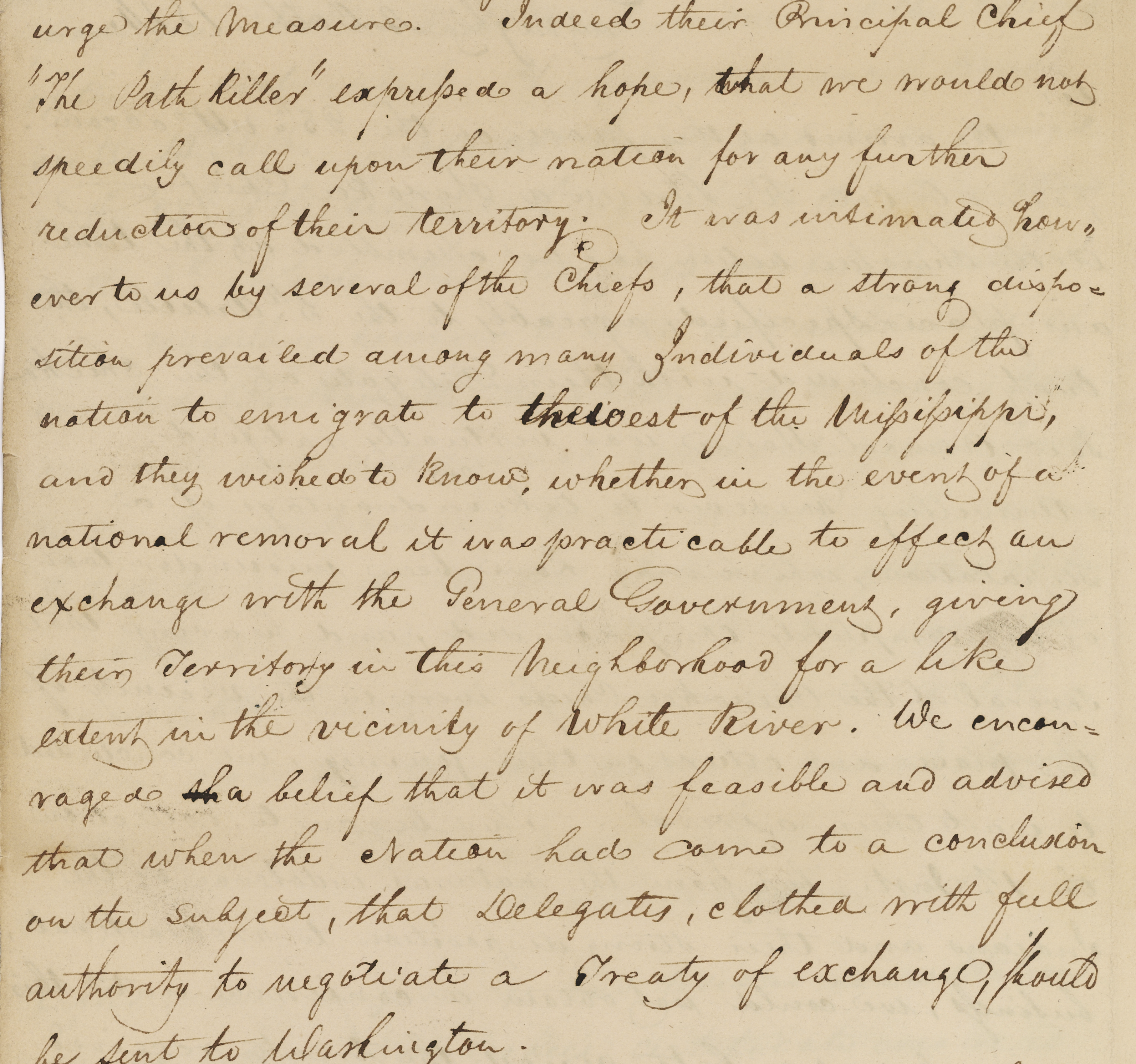
At midnight on 4 October 1816, Andrew Jackson and David Meriwether dictated a letter to be sent to William H. Crawford, Secretary of War with a summation of the treaty and other comments. In this letter at image 113, they talked about the removal West of the Mississippi. Several Chiefs inquired about the effects on the nation.
It was internalize to us however several of the chiefs that a strong disposition prevailed among many individuals of the nation to emigrate to the west of the Mississippi and they wished to know whether in the event of national removal it was practicable to effect an exchange with the General Government. .1
The Removal Bill
Americans elected Andrew Jackson of Tennessee as president in 1829. The Removal Bill of 1830 initiated the voluntary Indian removal. It was also known as the Indian Removal Act. The Indian Removal Act was passed in May 1830. It provided for lands in the Arkansas territory as a place to move to. So-called “West of the Mississippi River”. 2
Chief John Ross, Principal Chief of the Cherokee Nation, protested. The State of Georgia passed a bill in January 1830, claiming all of Northwest Georgia and the Cherokee Territory. This included Georgia State laws over the land.3 To add to the takeover of land, gold was found in Northwest Georgia. White men intruded by the hundreds searching for gold. 4 Georgia then sectioned off the land, and a lottery was held for 160-acre lots.
New Echota Treaty 1835
The Treaty of New Echota was signed on December 29, 1835, in New Echota, Georgia. Officials of the United States government and representatives of a minority Cherokee political faction, the Treaty Party, were involved.
The treaty set terms for the Cherokee Nation to give up its territory in the southeast. They were to move west to the Indian Territory. The treaty was not approved by the Cherokee National Council. Principal Chief John Ross did not sign it. Still, it was amended and ratified in March 1836 by the US Congress by one vote. This amendment and ratification made it the legal basis for the forcible removal. 5
The twenty-member council, “Treaty Party” that signed (by mark or signature).
Major Ridge, Te-gah-e-ske, James Foster, Robert Rogers, Tesa-ta-esky,
John Gunter, Charles Moore, John A. Bell, George Chambers, Charles F. Foreman, Tah-yeske,
William Rogers, Archilla Smith, George W. Adair, Andrew Ross, Elias Boudinot,
William Lassley, James Starr, Cae-te-hee, Jesse Half-breed,
Stand Watie, John Ridge. were the ones who provided instructions. 6
John Ridge, with this group, held 3/8 interest of Chief Pathkiller’s estate. This included the ferry, house and orchards at what is today’s Centre, Alabama. Review Chief Pathkiller’s ferries in this blog. John Ridge was the National Council’s Clerk (Secretary). William Lassley is the son of James Lasley. He is mentioned in the posts on James Lasley.
1835 Census
To know who would be potentially removed from Turkey’s Town, we need to review the 1835 census. A census was ordered to be taken of all Cherokees left in Alabama, Georgia, and Tennessee. This refers to the Henderson Roll. Below are the heads of households from Turkey’s Town. Rezin Rawlings took the census in Alabama. Recorded October 26, 1835. 7
page 15
N. Pathkiller, SE NO WAY, Writer, Nann, TE SEE, Johnson, Seeds, AT TA WO NO LE SKE, CHU WA STE TA, AH TA LO NE, Dirt Seller, Buffalo,
page 16
John E WAY NAH, SOR KE NEE, SE QUA TAH, TEN A YA CHEE, TA KEE, CHU QUA LOO KEE, Richard Ratliff Jr., George, Richard Ratliff Sr., James Lassley, Gun Fill, Pumpkin Pile, TU NE WAH, TOO NEY, Young Wolf,
page 17
Money Cryer, WAT TEE, James Carroll, John Ratliff, George Campbell, TE LU NA SKEE, Corn Tassel, Beaver Tail, John Riley, A NEY, Nelly, Auger Hole (Coosa),
Next Time
Who is on the detachment rosters? The Cherokee in Turkey’s Town were rounded up and forced to the stockade at Fort Payne. During June and July of 1838, they were forced from their homes.
Image 113, National Archives, Record Group 11, General Records of the United States Government, Series Indian Treaties; RIT #83; Ratified Indian Treaty #83, Cherokee, Chickasaw Council House September 14, 1816, There are 231 images of this with correspondence of letters and a journal. https://catalog.archives.gov/id/100220646↩︎
Cherokee Indian census of 1835 of the states of Georgia, Alabama, and North Carolina. Copy of the transcribed Alabama Section of the Old Book. Personal Copy of Jeffrey Sauls, received as a gift in 1992. ↩︎
Trust in the Lord with all your heart, and do not rely on your own understanding; in all your ways know him, and he will make your paths straight. Proverbs 3: 5-6 CSV
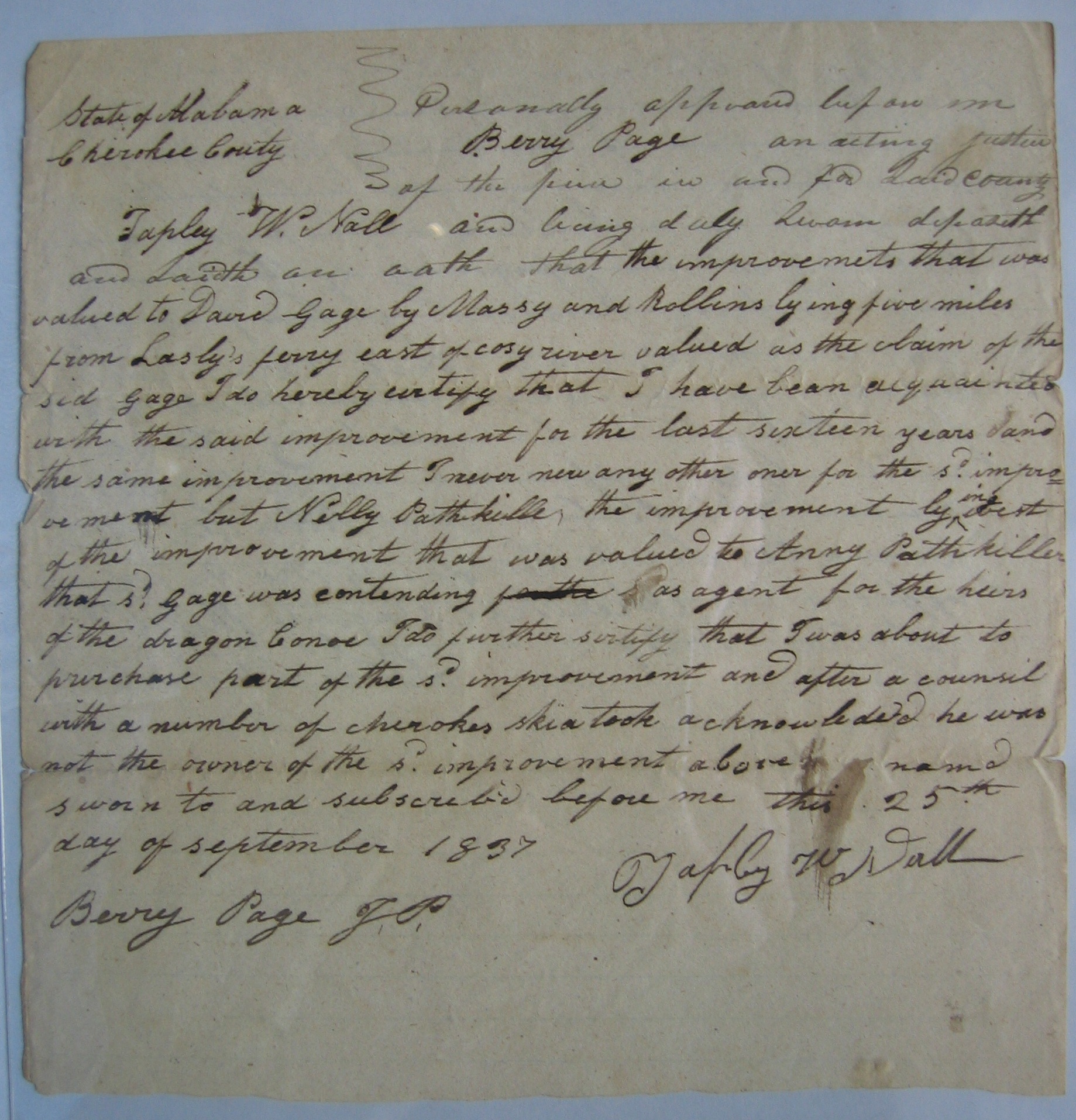
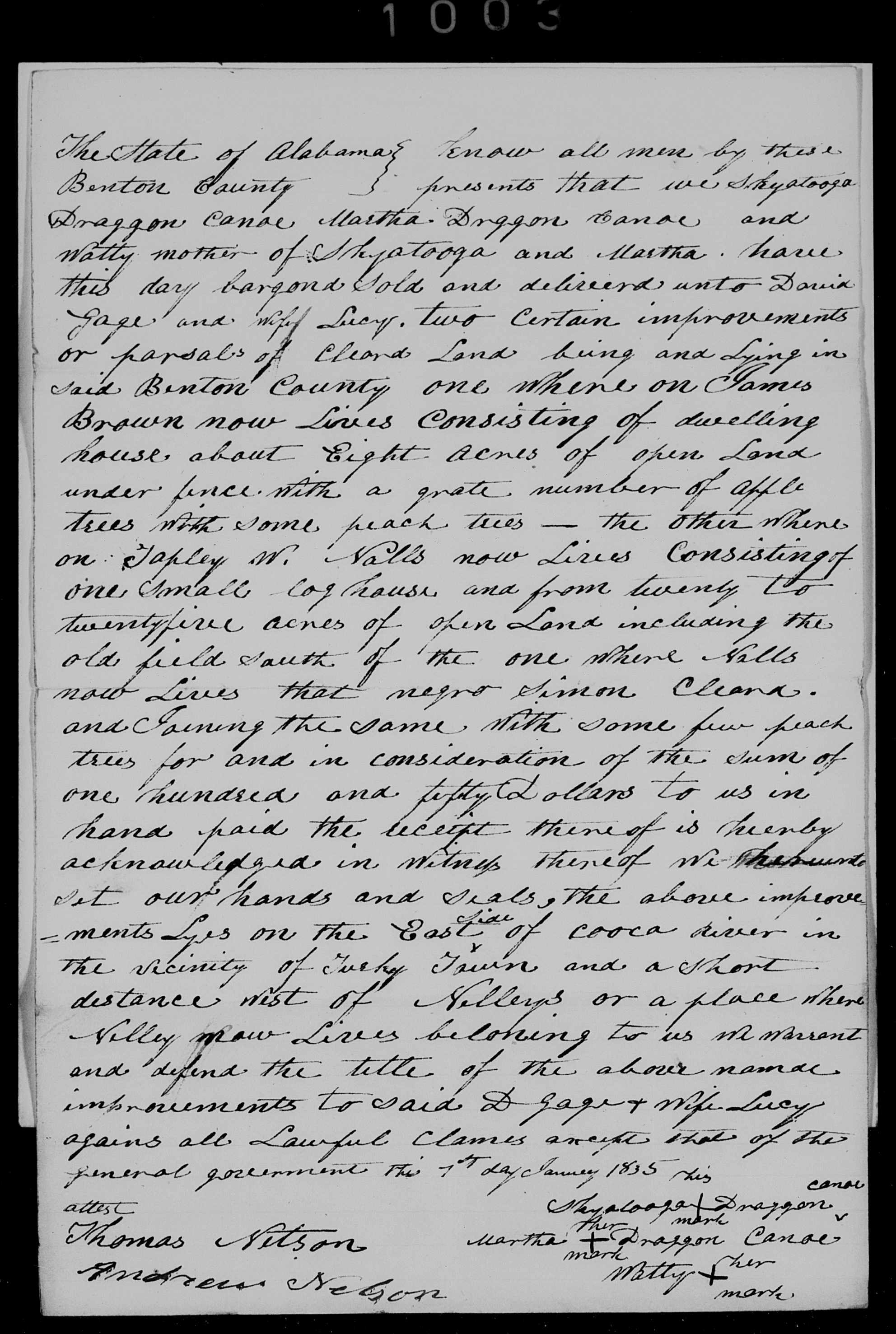
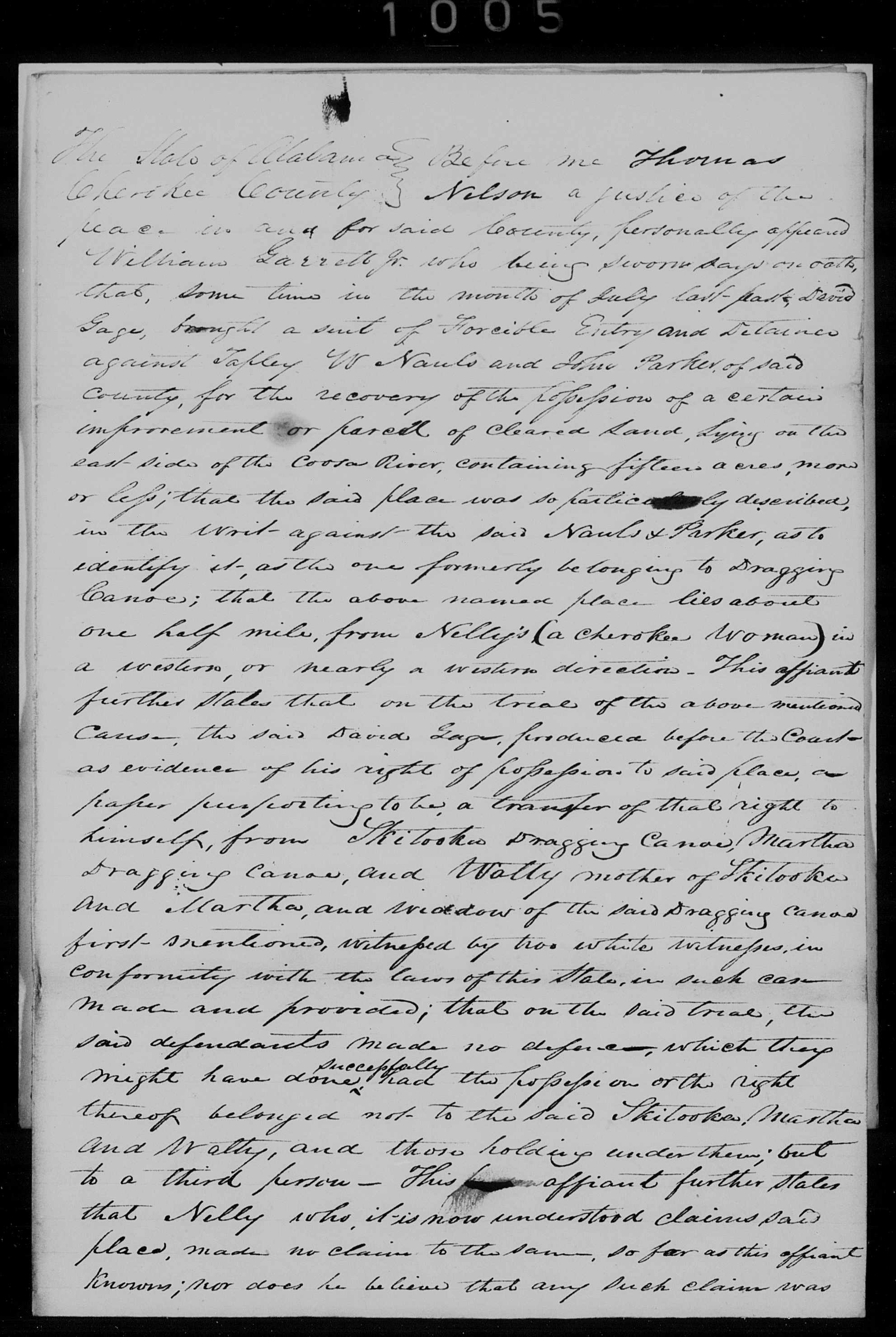
As we continue with David Gage in Turkey’s Town, we see that he is involved with Tarpley W. Nall. Tarpley W. Nall was trying to buy a part of Nelly’s farm. This farm is on the East side of the Coosa River. Modern-day Alford’s Bend. Review the previous documents. All of this property was Chief Pathkiller’s until he and his wife, Peggy, separated (divorced). Peggy has gifted the improvements to her daughter, Nelly. Nelly has gifted them to her daughter Anna. Dragging Canoe (deceased), Chief Pathkiller, and Peggy’s son’s family are claiming it along with David Gage. Confusing? Sky-a-too-ka, the son of Dragging Canoe, has enlisted David Gage on their part. Tarpley Nall decided not to buy after speaking with some Cherokee. He also said Sky-a-too-ka said he is not the owner. Tarpley W. Nall is a white man not married.
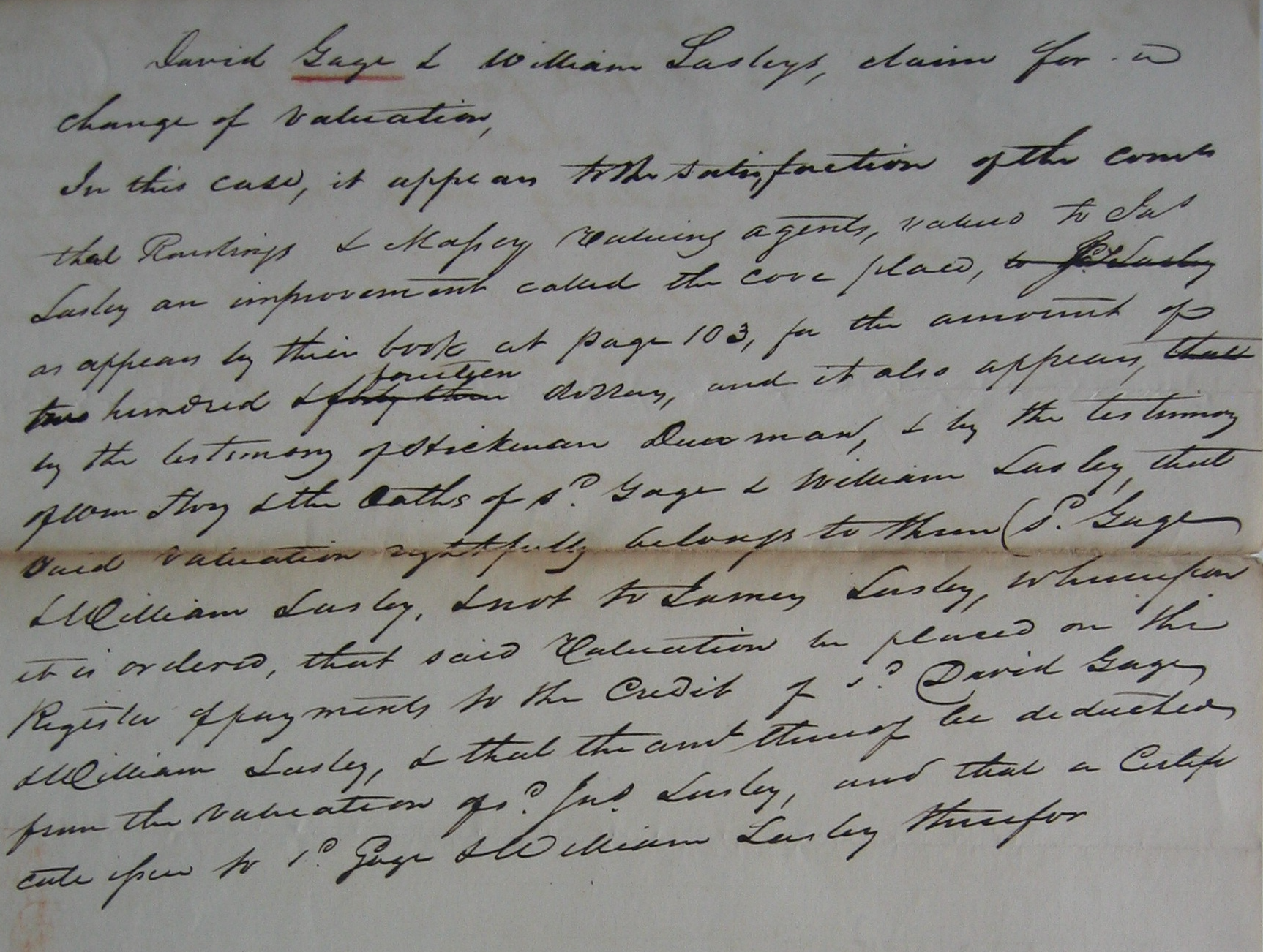
David Gage is involved with William Lasley. William is the son of James and Elizabeth Lasley. Elizabeth is Elizabeth Wicket, a Cherokee woman. James and Elizabeth separated in 1822 when Elizabeth wanted Big Cabin as a husband. You can review this in the section on James Lasley. The following document is where William Lasley is try to buy an improvement next to his father. The location of this is about four miles north of modern-day Turkeytown Creek. It would be on Spring Avenue. This is near modern-day Croft Ferry. Croft Ferry is James Lasley’s Ferry.
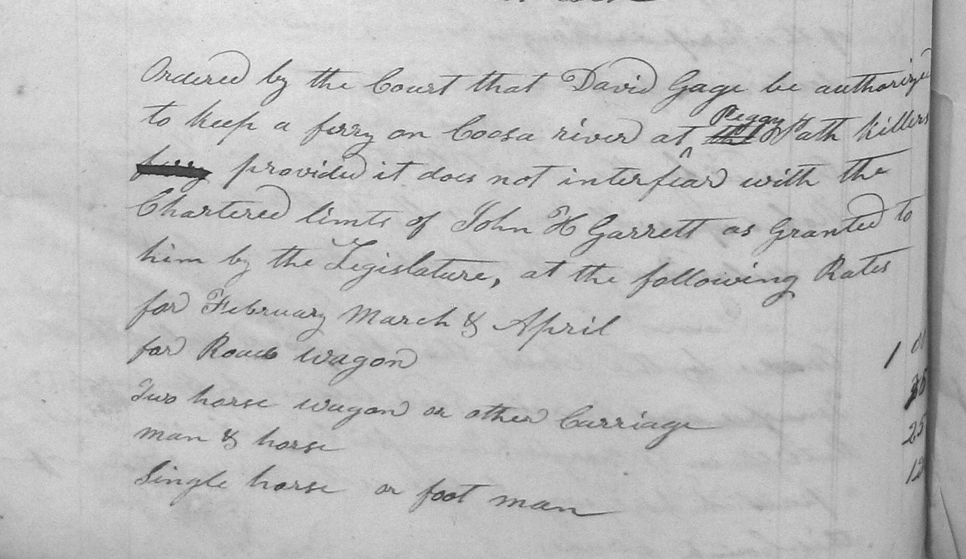
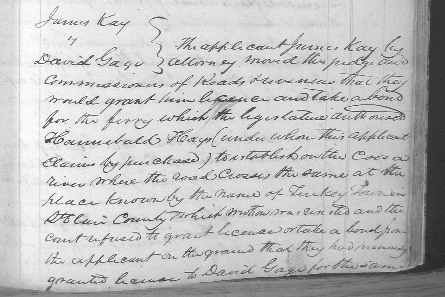
David Gage assisted James Kay in acquiring Chief Pathkiller’s original ferry. When Chief Pathkiller and Peggy separated Chief Pathkiller moved north and “took” a new wife. He started the improvements that would become Pathkiller’s Ferry, modern-day Garrett’s Ferry, Centre, Alabama. Peggy was left with the original ferry and improvements. This was one-and-a-half miles south of Turkeytown Creek. This is modern-day Fitts Ferry. This separates Alford’s Bend on the east side from White’s Chapel/Gaston School area on the west side.
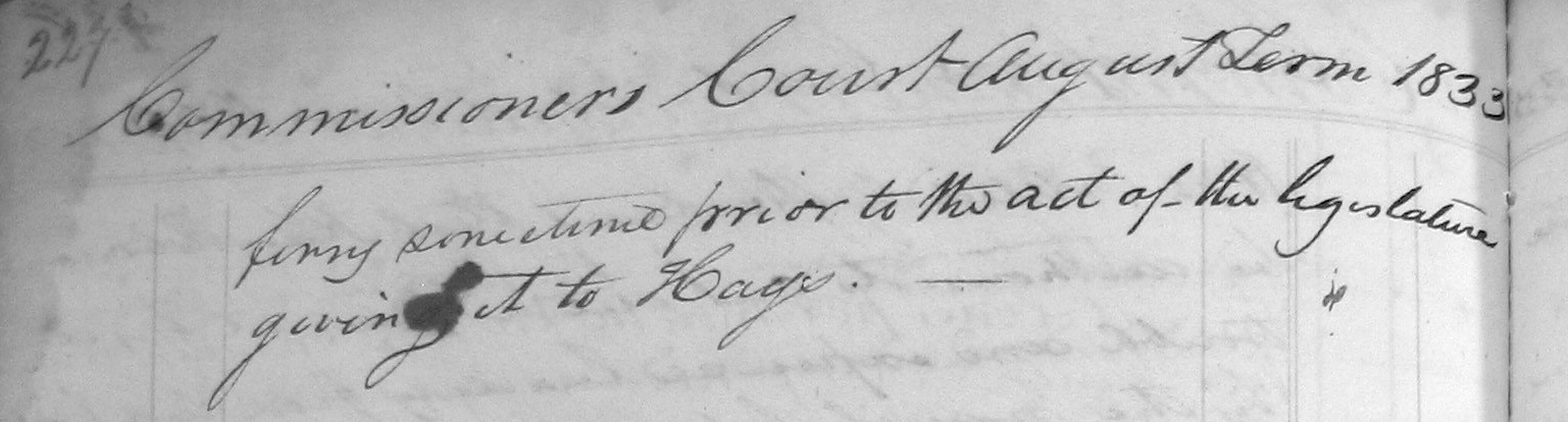
John Ratliff filed a Claim for this ferry on January 16, 1837 (he was one of four owners). He filed it before Josiah Harper, Acting Justice of the Peace for Cherokee County, Alabama. He stated that the Ferry was 1½ miles below Turkeytown and was then in the possession of James Kay. He said that a white man named Hays took the ferry from him. This happened shortly after the laws of Alabama were extended over the Cherokee lands in January 1832.7
The Original Patentee for the ferry’s location was James Kay. He homesteaded the west side of the ferry.11
Conclusion
David Gage, a notable person of Turkey’s Town. He and his family moved west during the Trail of Tears. They moved on their own. They are not listed on a detachment roll for the Trail of Tears. They settled in Texas.
He was elected the first Constable of Turkey Town, Alabama.
Also confirmed in these documents is that Turkey’s Town is in modern-day Etowah County. All of the documents state, “five miles below Lasley”. Alford’s Bend and Croft Ferry are in Etowah County, modern-day.
NARA, Record Group 75, Entry 236, Miscellaneous Claims Papers, 1836-1839, Records of the Bureau of Indian Affairs, Image 449, National Archives Building, Washington, DC ↩︎
John Ratliff’s Spoliation Claim for a Ferry and Improvement. Folder of John Ratliff; Miscellaneous Claims Papers, 1836-1839, of the First Board of Cherokee Commissioners, Entry 236; Records of the Bureau of Indian Affairs, Record Group 75; National Archives Building, Washington DC. ↩︎
St. Clair (AL) County Court Minutes (1828-1834), March-August, 1833 page 172 ↩︎
Bureau of Land Management, General Land Office Records, Eastern States Office, Springfield, VA. Pre-emption Certificate #6,885 for James Kay of Cherokee County Alabama issued June 1, 1845 for fraction “A” of fractional Section 20 in Township 11 of Range 7 East. Pre-emption Certificate #8,419 for James Kay of Cherokee County Alabama was issued April 10, 1847 for the northwest quarter of the southwest quarter of Section 20 in Township 11 of Range 7 East. Both in the District of Lands subject to Sale at Lebanon Alabama. http://www.glorecords.blm.gov/PatentSearch/↩︎
Trust in the Lord with all your heart, and do not rely on your own understanding; in all your ways know him, and he will make your paths straight. Proverbs 3: 5-6 CSV
This is the last person I am posting in the “Notable People of Turkey’s Town, Chapter. David Gage is a white man married to a Cherokee Woman. She is Lucy (she is of the Fish family, not a surname). The Fish family lived in Will’s Valley. David and Lucy have a farm in Will’s Valley. He also has a farm in Turkey’s Town. He served many Cherokee people of the area as their representative (like a lawyer). I will show documents. I will also show who he was involved with. This will help you understand his role and his involvement with Turkey’s Town.
The following is from the GINI website. I know some of the people who helped with the research for this profile, so I trust it. It is an overview of David Gage.
GAGE, DAVID (1796–1854). David Gage, early settler and legislator, was born in Kentucky (or White County, TN according to enlistment records for War of 1812) in 1796. He moved to Texas from Alabama in 1839 and, on May 21, purchased a fourth of the Leonard Williams league; he settled in the Williams Settlement in southern Rusk County, near Mount Enterprise. A few months later he organized and was made captain of a company of minutemen for protection against the Indians. He served with the company during 1840 and 1841. Gage was elected representative to the Eighth and Ninth congresses of the republic, December 4, 1843, to June 28, 1845, and in 1845 was elected senator for the Fourth District and delegate to the Convention of 1845. After annexation he served three terms in the Texas legislature. He died at his home near Mount Enterprise in 1854.
A BRIEF HISTORY OF DAVID GAGE’ The homesite of David Gage is located in the southern part of Rusk County, in the John Rutland survey, approximately five miles north of Mt. Enterprise and approximately two miles southwest of the community of Minden. This location is just north of what is now the ASH Griffin farm. His homesite is described by the Handbook of Texas as being one-fourth of the Leonard Williams league in Southern Rusk County, near Mt. Enterprise, Texas. He was granted a 3rd class certificate for 320 acres of land as an immigrant after October 1, 1837, and prior to January 1, 1842. The Certificate is dated December 31, 1839.At the time of his death, he owned approximately 12,000 acres of land in the southern part of Rusk County.
He immigrated to Texas in May 1839, from Arkansas. The Handbook of Texas states (in error) he came to Texas from Alabama. He was a veteran of the War of 1812. He enlisted 10 July, 1814, and was discharged 9 July, 1819, at Ft. Scott, Ga. He was a corporal in Capt. Thomas Blackstone’s Company, Seventh Regiment of Infantry. From 1840-1841, David Gage served as Captain of a company of minute men in Rusk County. These minute men were organized for protection against the Indians.
He was elected Representative to the Eight and Ninth Congresses of the Republic of Texas December 4, 1843, to June 28, 1845. In 1845, he was also elected a delegate to the Annexation convention. He was a signer of The Joint Resolution for annexing the Republic of Texas to the United States. He was also a signer of the Constitution of the State of Texas adopted in convention at the City of Austin, August 27, 1845. After Annexation, he was elected to serve three terms in the State Legislature: the 2nd, 1847-48; the 3rd, 1848-1850; and the 5th, 1853-54. His name appears along with the other sixty signers of the Resolution and Constitution on the west wall of The Memorial Museum, Univ. of Texas Campus, Austin, Texas.
On February 5, 1847, a Post Office was established at Gage’s with David Gage appointed Post Master. It was discontinued on October 21, 1847. (See letter, Gen. Service Administration, dated May 14, 1962.) David Gage married Elizabeth Austin in Madison County, Alabama, February 28, 1820. He had one known child, William Patterson Gage, born 1821. (1860 Census, Rusk County gave his age as 39.) Record is lacking of dissolution of this union by death or otherwise.
The next record we have of David Gage is in Cherokee Country in Northeastern Alabama, where he was elected Constable of Turkey Town, St. Clair County, on January 13, 1833. He was one of seven captains presiding over the St. Clair County Beats, his beat being Turkey Town. David Gage’s second wife was Lucy Fish, a full-blooded Cherokee Indian. Their marriage was about 1832 or 1833, as Rusk County 1850 Census shows the age of their oldest child, Mary Ann, as being 16. Their second child, Eliza Jane, age 12, (married James A. Bane, Laneville) was shown as being born in Arkansas. David Gage had five farms in DeKalb County, Alabama. I have a list of property for which the U.S. paid him when the Indians were removed from Alabama to Indian Territory, Oklahoma. He lived on Little Wills Creek, DeKalb County, Alabama. This inventory was dated September 29, 1836, and valued at $3,843.54. David Gage died April 26, 1854 at his home near Minden, Texas. His place of burial is on the west side of Highway #259, on the first little hill across the stream, south of the farm of the late W.G. Hodges. The burial place is located on the farm known in the 1920’s as the Bill Shadden farm. 1
The above is mostly about David Gage after he moved from Turkey’s Town. How is he connected?
Turkey Town Constable
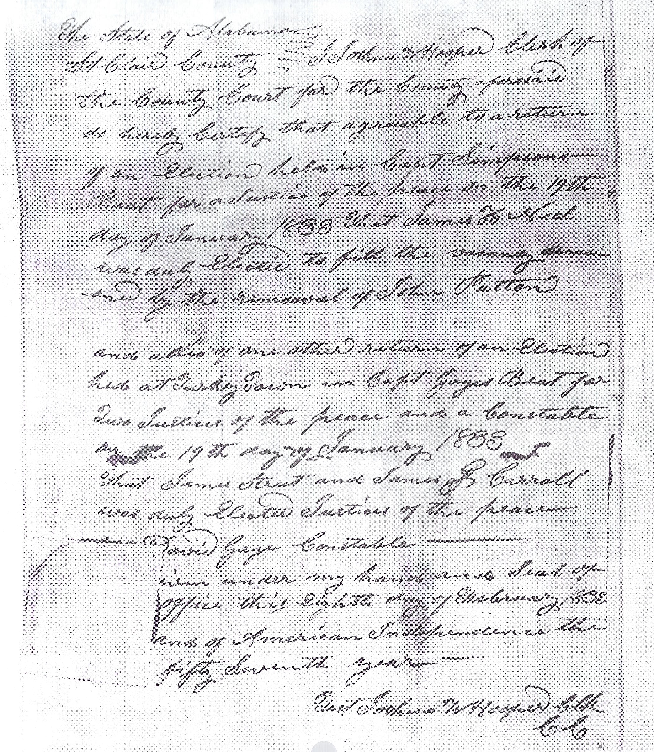
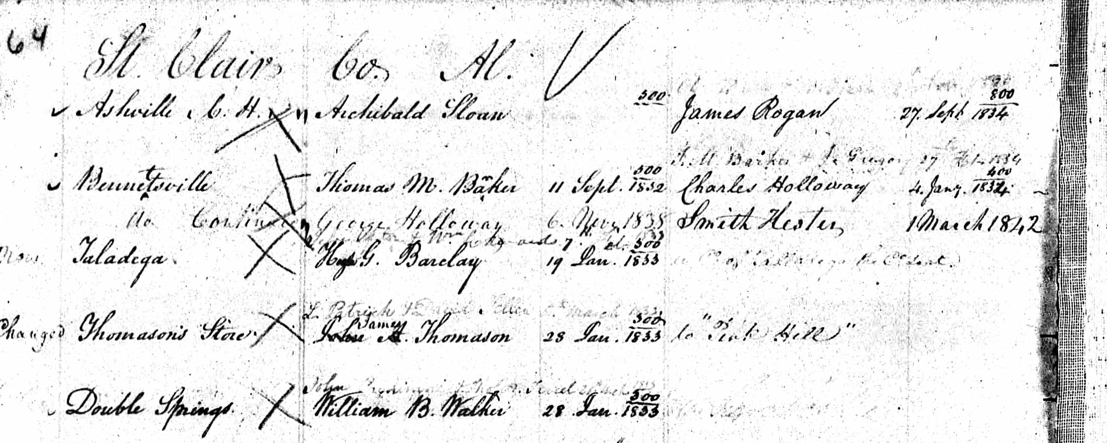
The first election held in Turkey Town was in 1833. This would become Cherokee County in 1836. It later became Etowah County, Alabama, in 1868. Saint Clair County, Alabama, claims the territory. David Gage was elected Constable. Notice that the “beat” in Turkey’s Town is “Capt. Gage’s beat.
“and also of one other return of an Election held at Turkey Town in Capt Gages Beat for Two Justices of the peace and a Constable on 19th day of January 1833 That James Street and James G Carroll was duly Elected Justices of the peace. Capt David Gage Constable ———–“
There was no Etowah or Cherokee County at the time. This is the first election in what would become Etowah County, Alabama. A constable in the 1800s was a local law enforcement officer. They were responsible for keeping the peace, serving legal documents, and enforcing minor laws. They represented the primary form of policing. The Treaty of 1830 with the Cherokee set in motion the removal to the West. The Treaty of Cusseta in 1832 moved Alabama to proclaim laws over all of what would become Alabama.3 So this brought the election to take place. Saint Clair County claimed the territory that is Turkey Town. Follow the timeline. 1830 Treaty, 1832 Treaty, 1835 Treaty, then Trail of Tears, 1838.
As a Constable, David Gage can represent people in legal proceedings.
David Gage and Chief Pathkiller’s Family
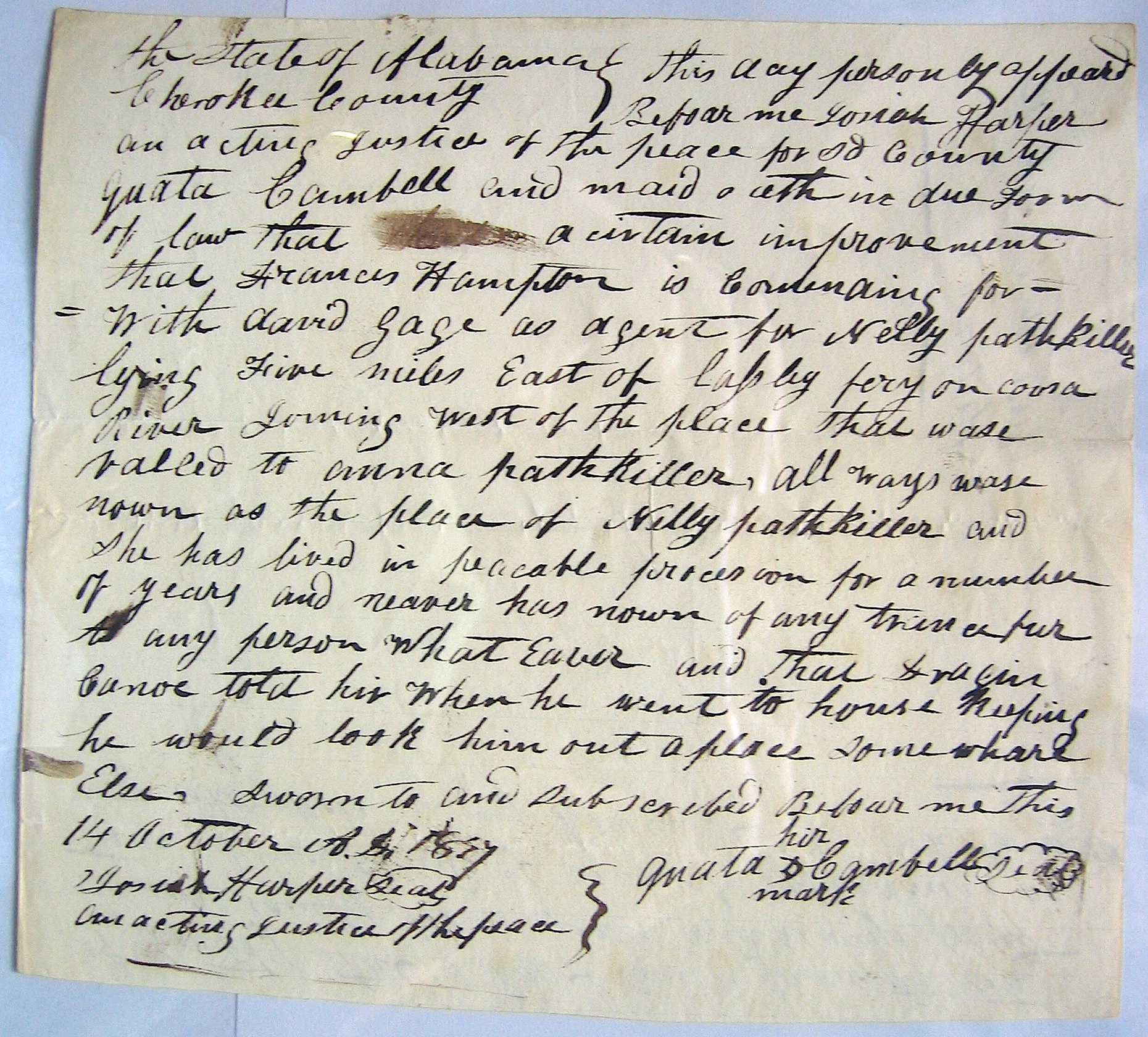
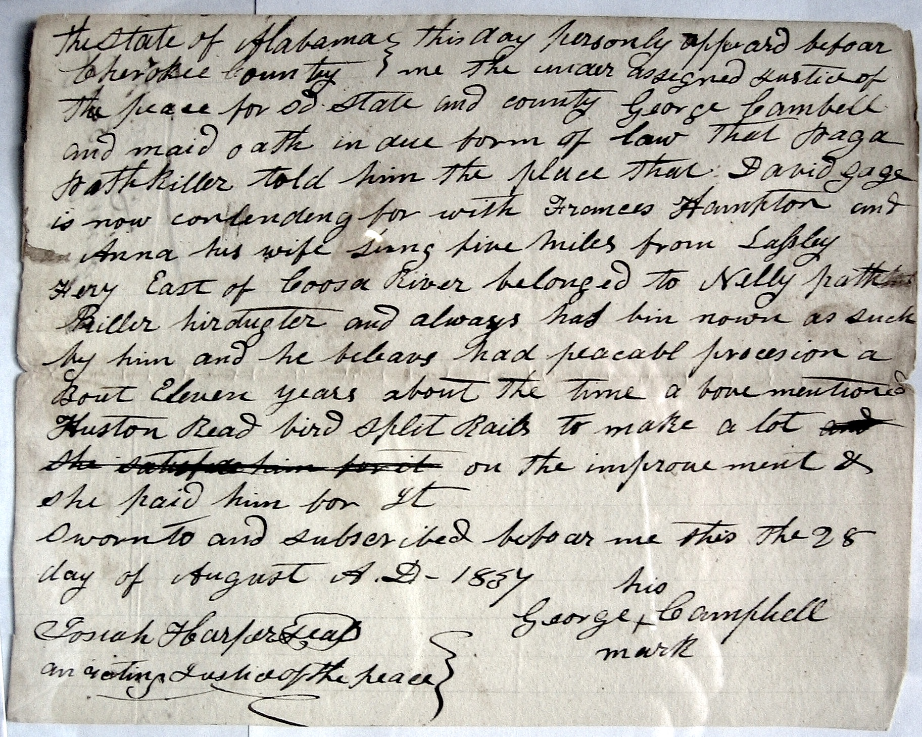
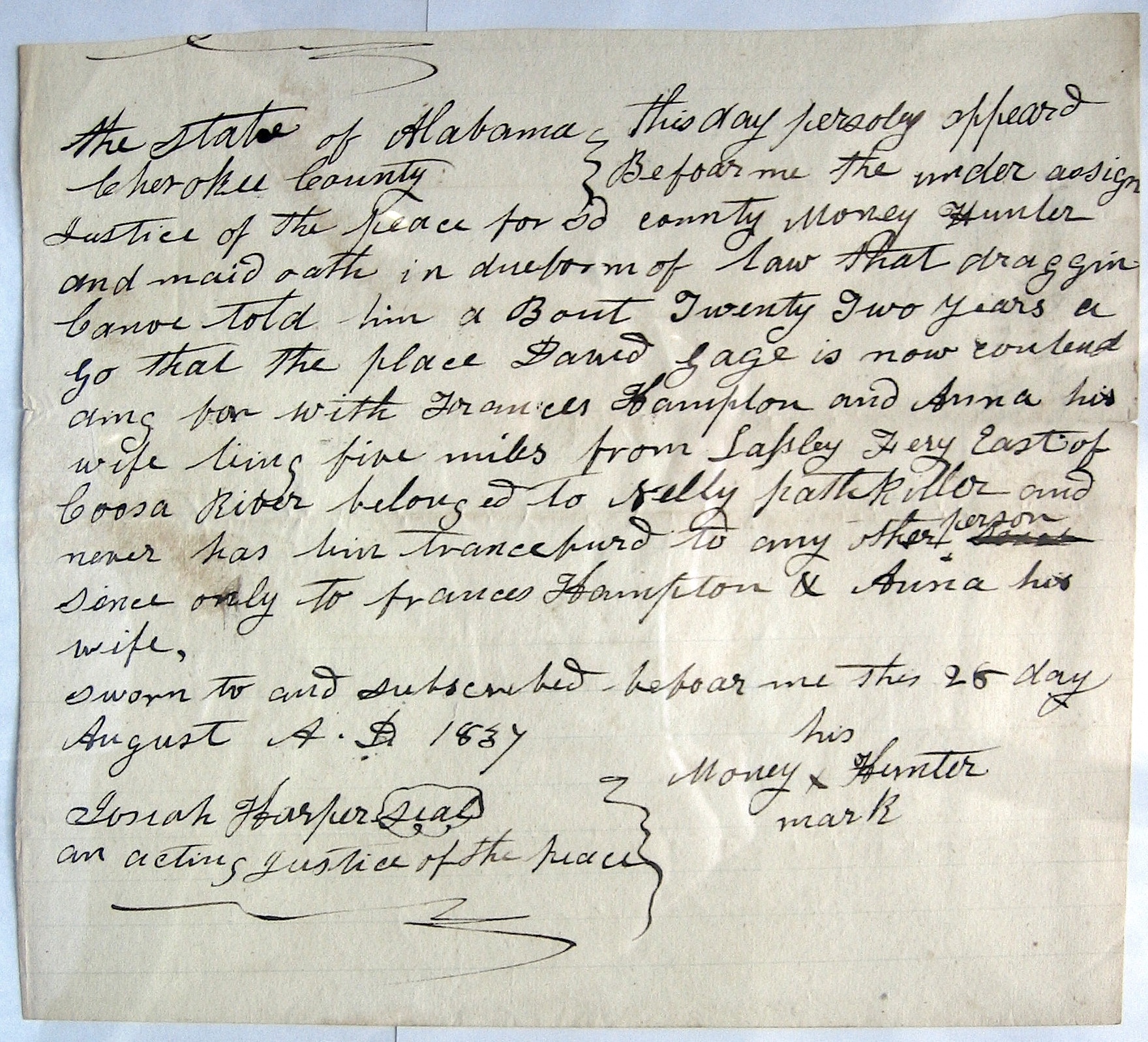
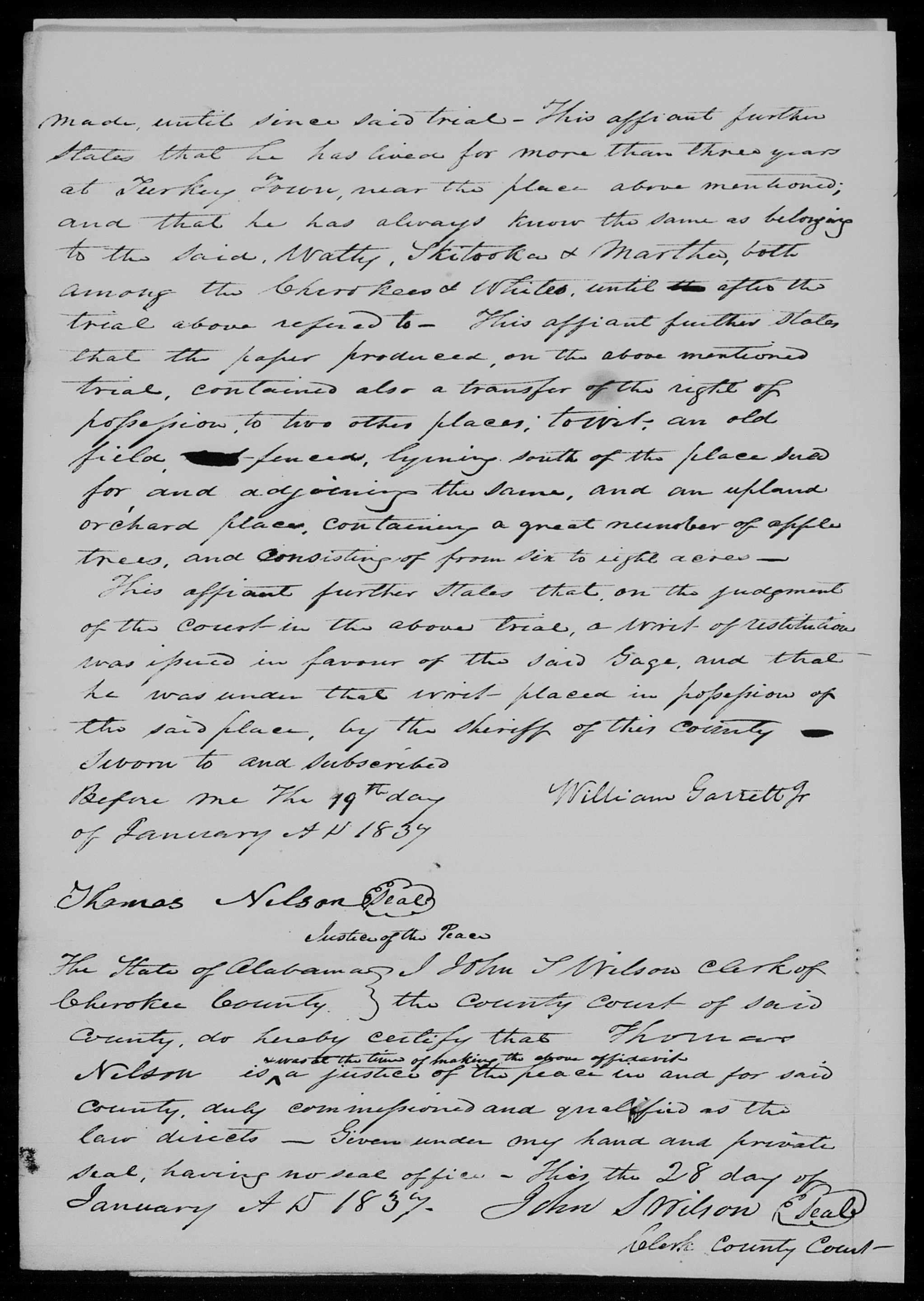
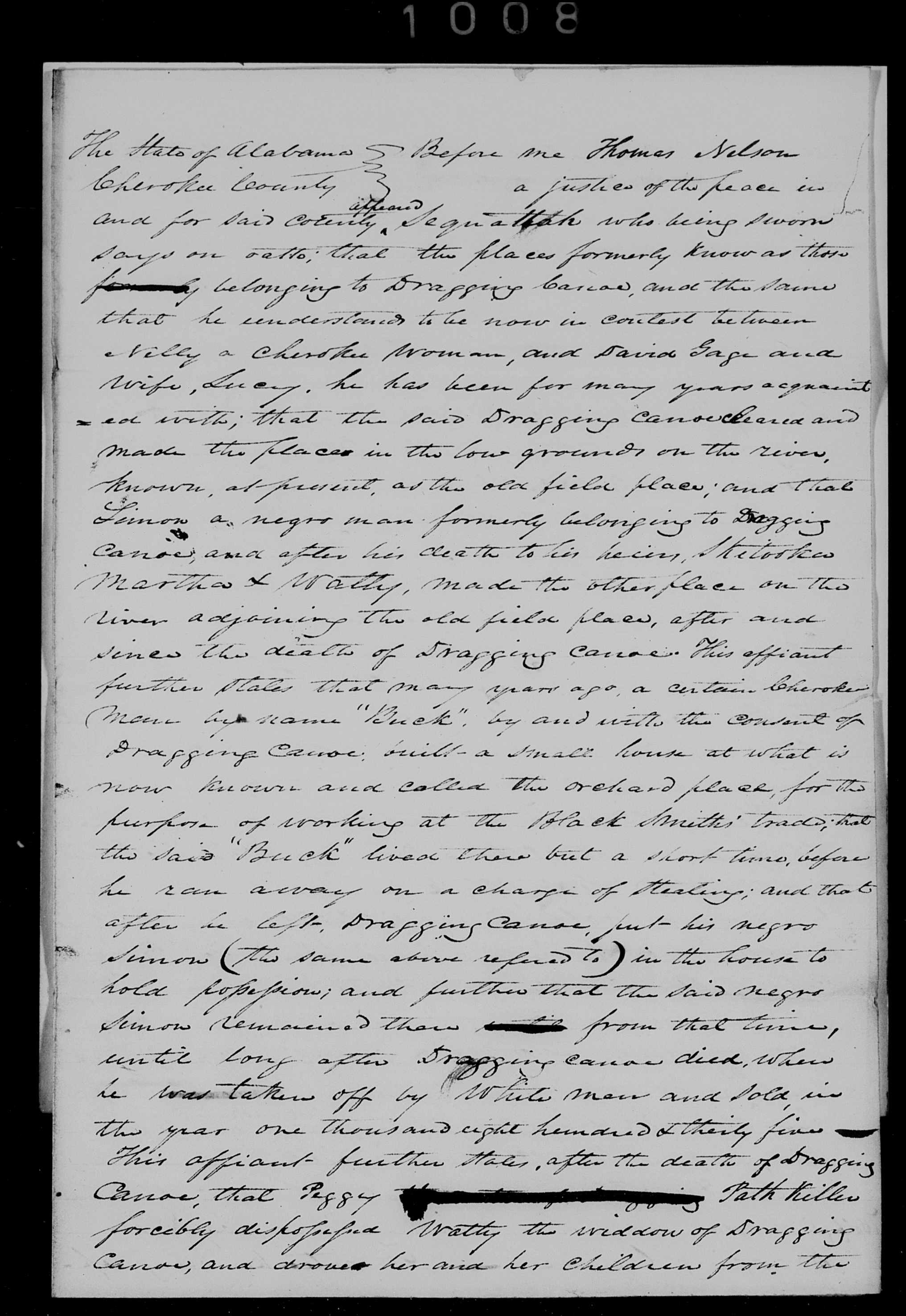
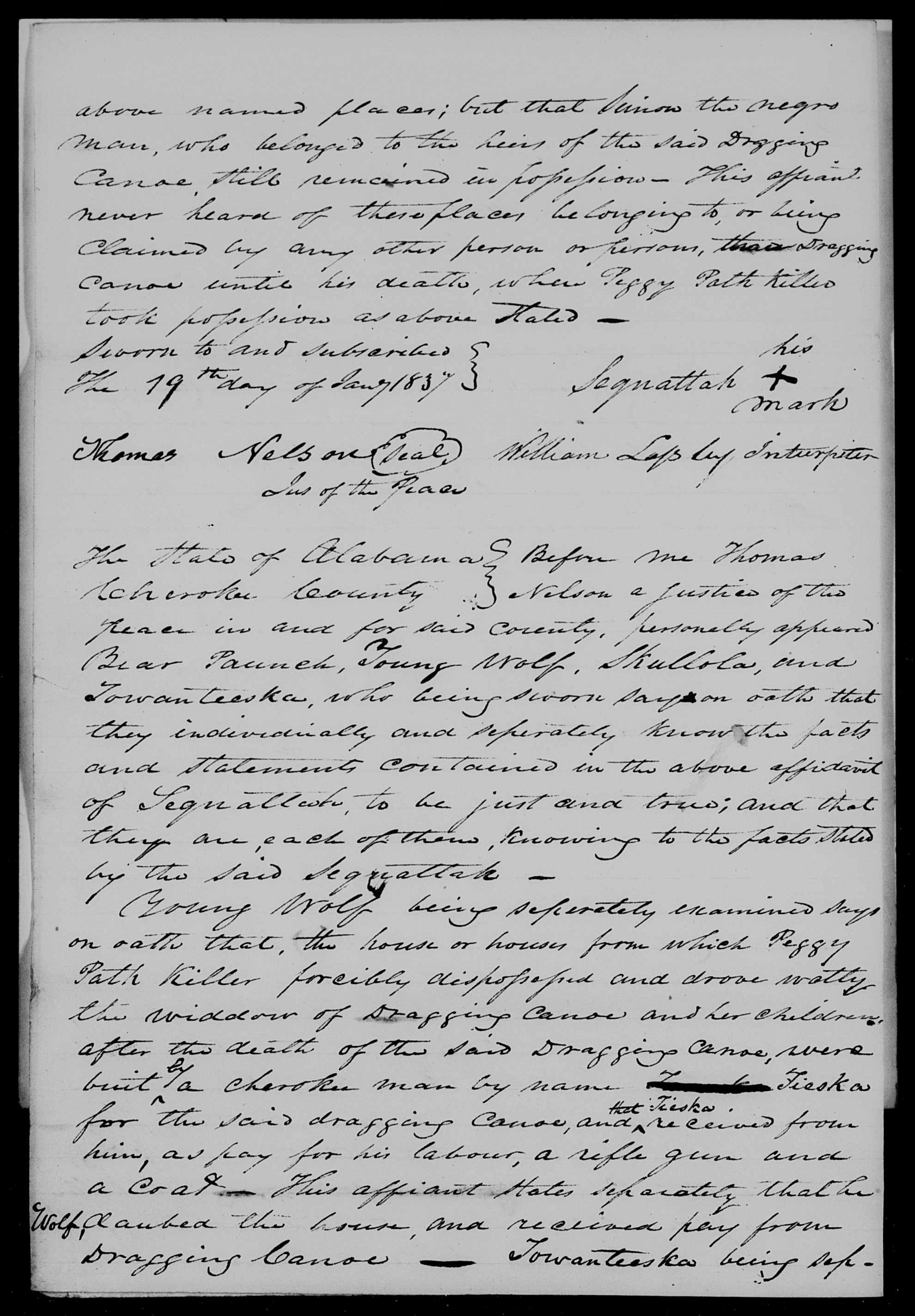
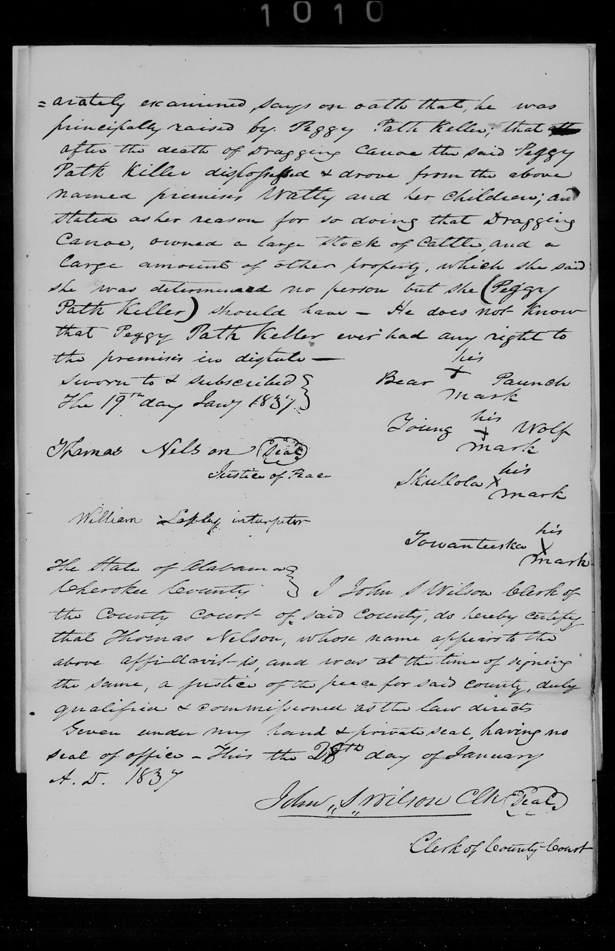
David Gage became involved with Chief Pathkiller’s family. Dragging Canoe, Chief Pathkiller, and wife Peggy’s son died in 1833. Dragging Canoe’s son, Sky-a-too-ka, entered into a dispute with Anna, daughter of Nelly (sister of Dragging Canoe). The disagreement was about who had the right to the improvements on the East side of the Coosa River. This site is the old residence of Chief Pathkiller. This is at today’s Fitts Ferry on the east side of the river, known as Alford’s Bend. This is in present-day Etowah County, north of Gadsden. This area became Peggy’s when Chief Pathkiller move north and took a new wife. He created the new improvements, which are the Garrett farm in Centre, Alabama. At the time of the dispute, Dragging Canoe, Chief Pathkiller, and Peggy were deceased. When Peggy died, she left it to Nelly. Nelly gifted it to Anna, who is married to Frances Hampton. Sky-a-too-ka is claiming this for himself, his mother, Watty, and his sister, Martha.
The following are documents showing Sky-a-too-ka’s claim. These involve several people. Several of them are white people who are intruders now moving into the area because of the Treaties. The first document is recorded in Benton (Calhoun) County. This county also would claim Indian territory. Read them closely. Click on them to make them larger. These also confirm Turkey’s Town’s location in today’s Etowah County, Alabama. They are all from the NARA microfilm. 4
Image 133, Notice that Benton County (Calhoun) is also claiming the area.Image 135Image 136Image 138Image 139Image 140
If you read these closely, you see the claim of Peggy running Dragging Canoe’s family off this property. In Cherokee culture, the woman is in charge of the estate. She is and will be responsible for the girls in the family. Not the sons. You see this in Peggy’s will. She left everything to the girls and their families. She even left some of it to her sister’s daughter. Dragging Canoe was not included in her will. He is a male and is to take care of himself.
One of the persons involved is Tarply W. Nalls. He is a white man. He is involved with others other than the Pathikllers. He is doing his best to take advantage of what is going on and the move west. I will post his response to his trying to buy or acquire parts of this property.
Another person is William Garrett, Jr. He is the son of William Garrett. William Garrett is the brother of John H, Garrett. John H. Garrett will dispose (move off) John Ridge’s tenet. This is after Ridge acquired Chief Pathkiller’s ferry at today’s Centre, Alabama.
Next Time
I will leave this for you to ponder over. Review the documents again. This is the view of Dragging Canoe’s family. The maternal side of the family is the dominant side for the Cherokee people. I will post next time Tarply W. Nalls’s response for attempting to purchase part of the improvement. I will show Nelly’s side of this dispute. I will introduce David Gage’s involvement with William Lasley. He is the son of James Lasley and Elizabeth Wickett Lasley. Notice that he is the interpreter on the documents. His father is white and his mother is a full-blood Cherokee.
National Archive Record Administration, Microfilm No. 574, Special file of the office of Indian Affairs, 1807-1904, Roll 51, File 183-184, Images 132-140. ↩︎
Trust in the Lord with all your heart, and do not rely on your own understanding; in all your ways know him, and he will make your paths straight. Proverbs 3: 5-6 CSV
We continue to uncover the history of John Riley. He is a notable person of Turkey’s Town. We explore his ferry and its connections to Gadsden, Alabama.
Our best research on this ferry is found in a report to the National Trail of Tears Association, 2009. Alabama Collection Camps, Forts, Emigrating Depots and Travel Routes Used During the Cherokee Removal of 1838-1839 1
Chapter Eight is about the ferries in Northeast Alabama on the rivers and streams. “Topography of the Removal Routes”, written by Mike Wren. Riley’s ferry/Walker’s ferry begins on page 251.
A Road called the Jacksonville Road crossed the Coosa River at this point. John Riley owned a Ferry on the Coosa River in what was described as Turkey Town Valley in Cherokee County.80 3Riley’s Ferry was the second most valuable on the Coosa River.
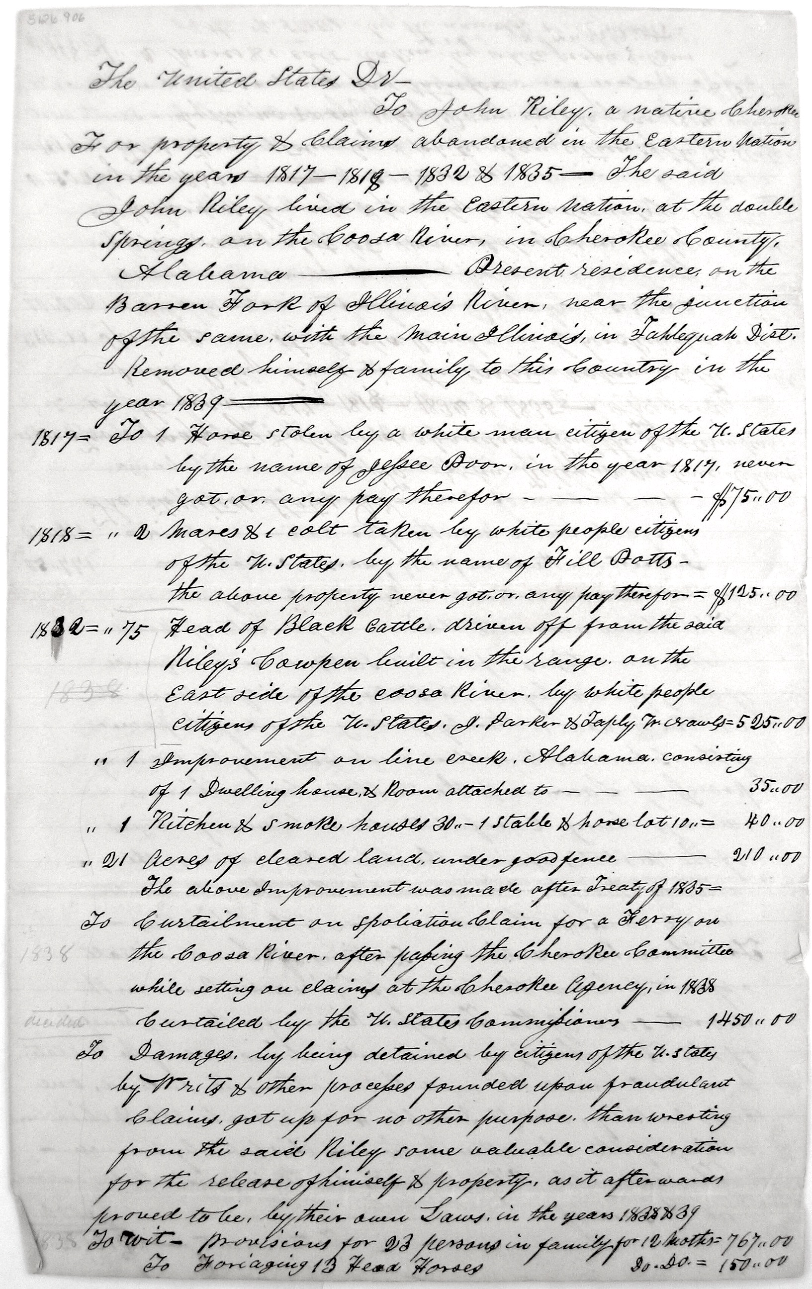
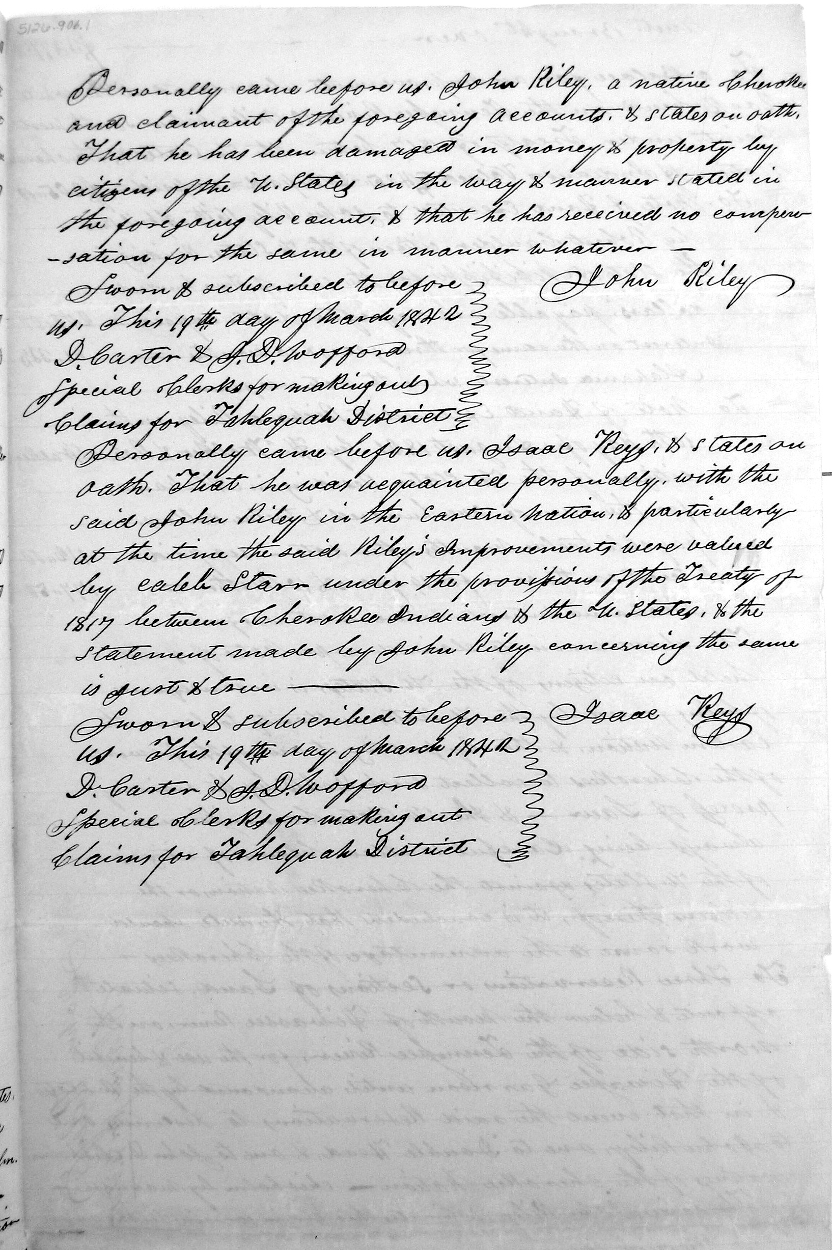
John Riley filed a claim for $3,000 for dispossession of his ferry on the Coosa River opposite the Double Springs by William B. Walker, a white man. Silas Choate confirmed his statement. It is interesting that W. B. Walker also confirmed Riley’s statements. The Claim was not allowed apparently because it had already been valued.81 4Riley also filed a claim on February 12, 1838 for spoliation of 6 years of rent from 1832.825In 1842, Riley petitioned for reimbursement of the aforementioned ferry rent of $1,450 and also for $112 for a “Note of Hand Executed to Richard Riley on the 10th day of August 1821 by H. Walker and Robert Walker, citizens of the U. States…”83 6On March 16, 1842 Mrs. Susannah Riley also filed a claim that included “Fifty dollars, note of hand on William Walker, citizen of the U. States, Executed in the year 1835, prevented from collection by her Removal West and Interest on the same for seven years, Alabama Inst.”84 7
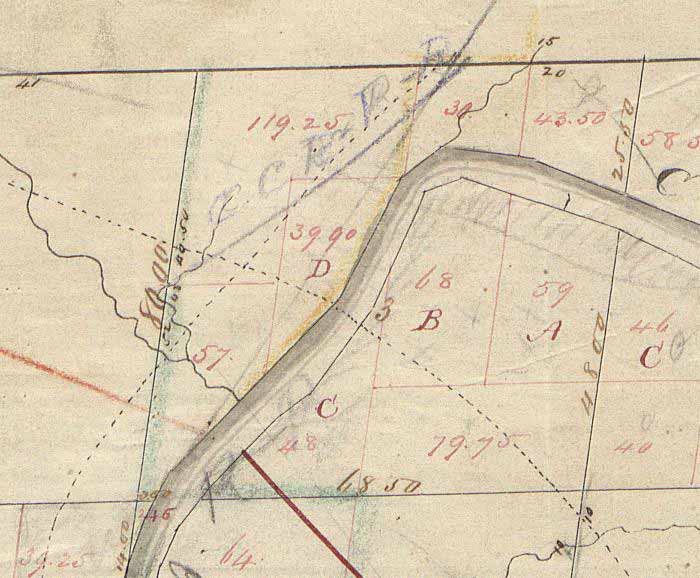
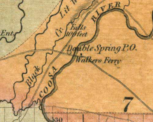
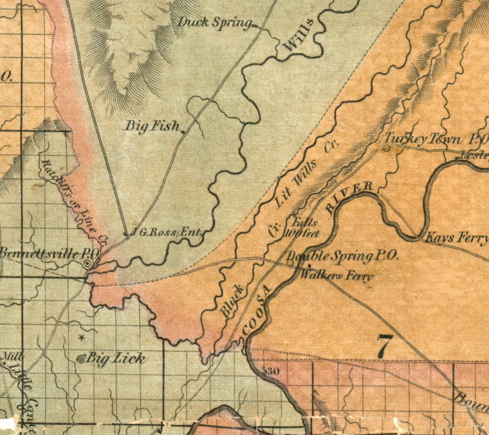
On LaTourette’s 1837 Map, the Ferry at the Double Springs Post Office is identified as Walkers Ferry. Double Springs is the present location of the City of Gadsden Alabama. The Jacksonville Road that crossed the Coosa River at Walker’s Ferry would today be U.S. Highway 431. There were no Walkers among the Original Patentees in Section 3.86 9Claim #958 in the Records of the 4th Board made by the Heirs of John Riley vs. US was for loss of a ferry from 1807 to 1819.87 10This likely refers to a different ferry.
Mike does not tell us how this connects to Gadsden, Alabama, in the report. Notice on LaTourette’s map: Walkers Ferry is plotted on the east side of the river. William B. Walker lived on the east side of the river. William B. Walker is listed as the Postmaster in 1833 for Double Springs. John Riley is still living here at that time in Turkey’s Town. Who established the Post Office? Postal records have not been found telling us who established the PO.
What Happened to William B. Walker?
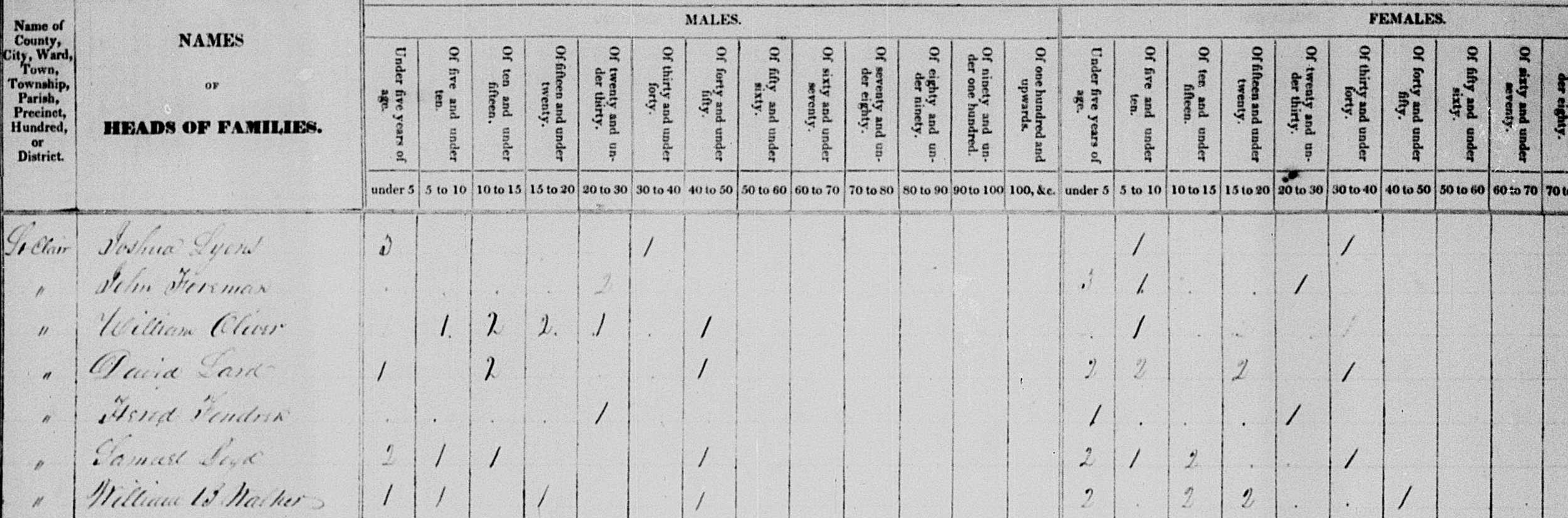
William B. Walker is listed on the 1830 US Census Record in Saint Clair County. He has a family. Where did they go?
William B. Walker 1830 US Census Saint Clair County, Alabama. From the website of FamilySearch.com
He is not on the 1840 census for Saint Clair County or Cherokee County, Alabama. Did they move off or did he die and his family move? The answers are unknown. Walker was the Postmaster for Double Springs, Alabama, as noted. He was paid $16.37 in September 1839 as the postmaster at Double Springs, Alabama.11 After the payment for the postmaster in 1839, all records of William B. Walker were lost or disappeared.
Ferry
Riley’s ferry will be called Walker’s Ferry by the early settlers. It shows up in the Saint Clair County records. The court minutes show who is in charge of the postal routes. They also show the authorization and fees for ferries. On page 203; “It is odrdered by the Court that Nathaniel Davis be appointed overseer of the road from William Walker’s ferry to the Benton County line. Road 2 grade.“12
You can read the record of the ferry as Walker’s Ferry. It list the fees. This was recorded in 1832.
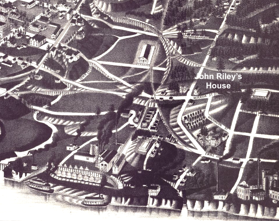
It will become Hampton’s Ferry then Ewing’s Ferry. The ferry landing and John Riley’s house will become the hub or center point for establishing a town. This town will be called Gadsden, Alabama.
Homestead
The 1928 Woman’s Club’s book records information about the beginning of Gadsden. This section was written by Mary E. Hughes (wife of Joseph R. Hughes, son of Gabriel). It was written in 1884 as the Woman’s Club noted.
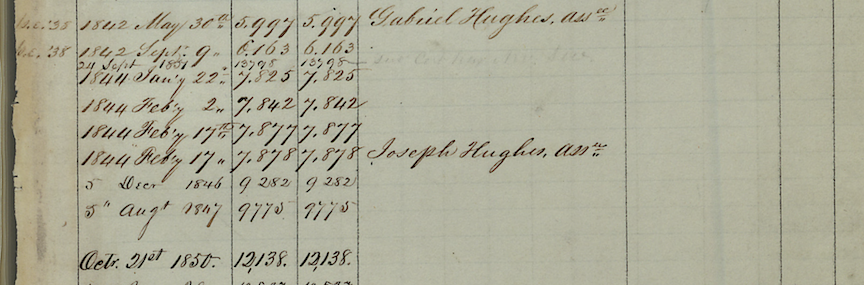
In 1844 these three men field entry to the Government for the land grants and received the patents in 1845. John S. Moragne entered sixty acres, Joseph Hughes entered twenty acres, and Lewis L. Rhea entered forty acres, which he sold to Joseph Hughes July 14, 1846. On these 120 acres the original survey of Gadsden was made. Page 15-16
The Steam boat landing was finally located at the foot of Broad street after much contention as other parties wanted it at Hampton’s (now Ewing’s) ferry. Having gained the victory, Messrs. Gabriel and Joseph Hughes and John S. Moragne laid off the town on their land in 1846 and deeded Captain Lafferty who located the land for them, a number of lots. They met one day by appointment to name their embryo city, at a building near the river not far from Barrett residence now stands and once decided to call the place Lafferty-and Lafferty it surely would have been but for the opposition of the Captain himself, who had met with them. . . they decited to name their town after the hero of the hour, General Gadsden. . . . Page 1814
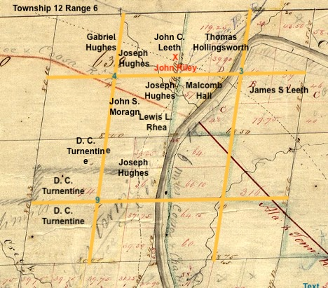
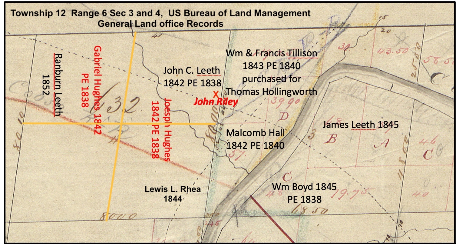
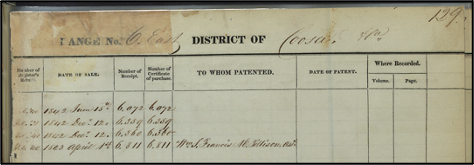
Here is a listing of the patent purchasers who homesteaded the property that would become Gadsden, Alabama, in the 1840s. You can see Joseph Hughes, John S. Morgan, and Lewis L. Rhea in the center.
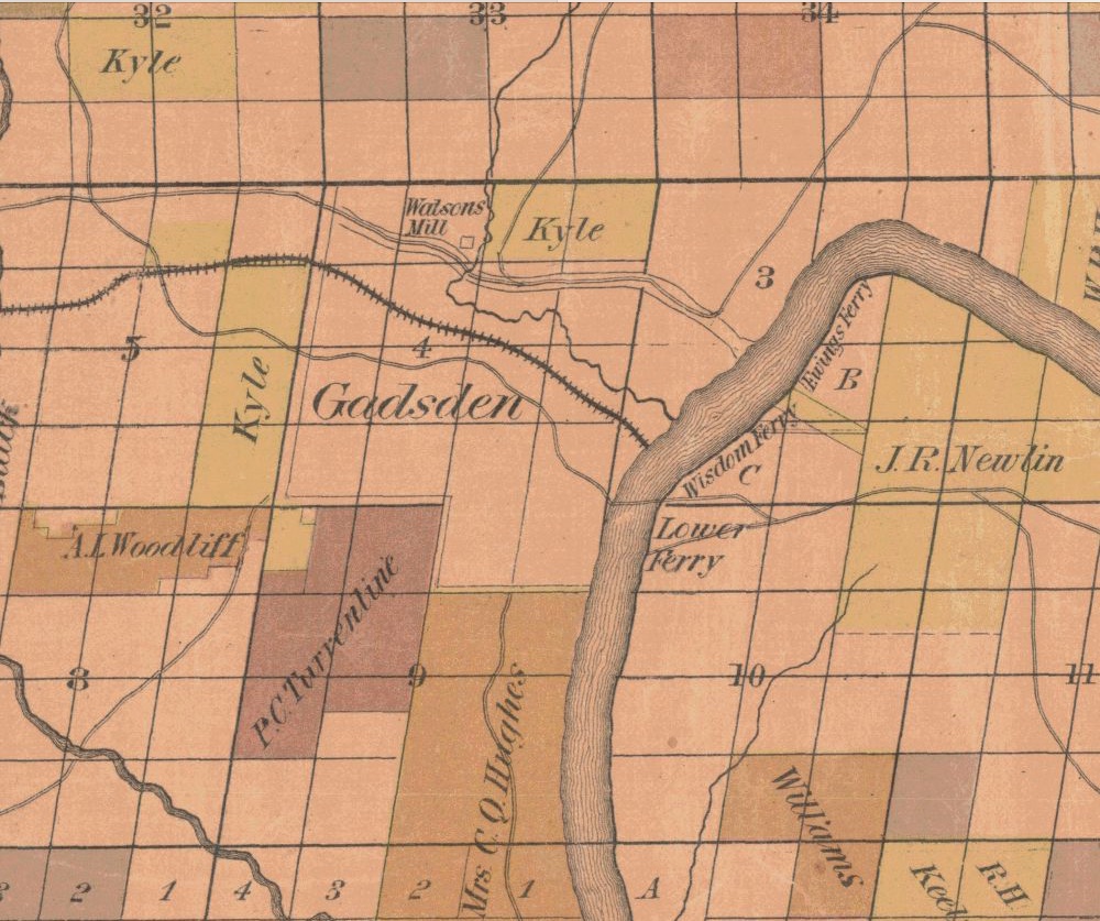
One last image of what would become Gadsden is the first map of Etowah County. Tallman drew it and it was published in 1877. The image comes from the University of Alabama’s website on Historic Maps of Etowah County, Alabama. You can see Ewing’s Ferry, the original Riley’s Ferry. You can see Wisdom’s Ferry, which is the Lafferty Landing and the ferry they created for it in 1846. Then there is the lower ferry, which is unnamed. You can see the location that is plotted out for Gadsden.
79. Survey of Township 12 South of Range 6 East, of the Huntsville (AL) Meridian, fraction north of Wills Creek and the Old Cherokee Boundary Line. Plat certified June 10, 1840 by James W. Weakley, Surveyor General of the public lands in Alabama. Jonathan M. Cunningham, Deputy Surveyor. http://www.glorecords.blm.gov/SurveySearch/ ↩︎
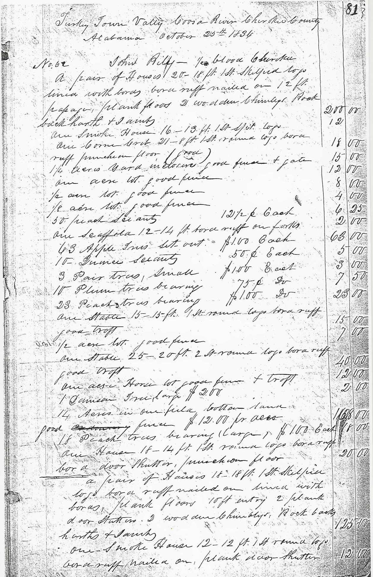
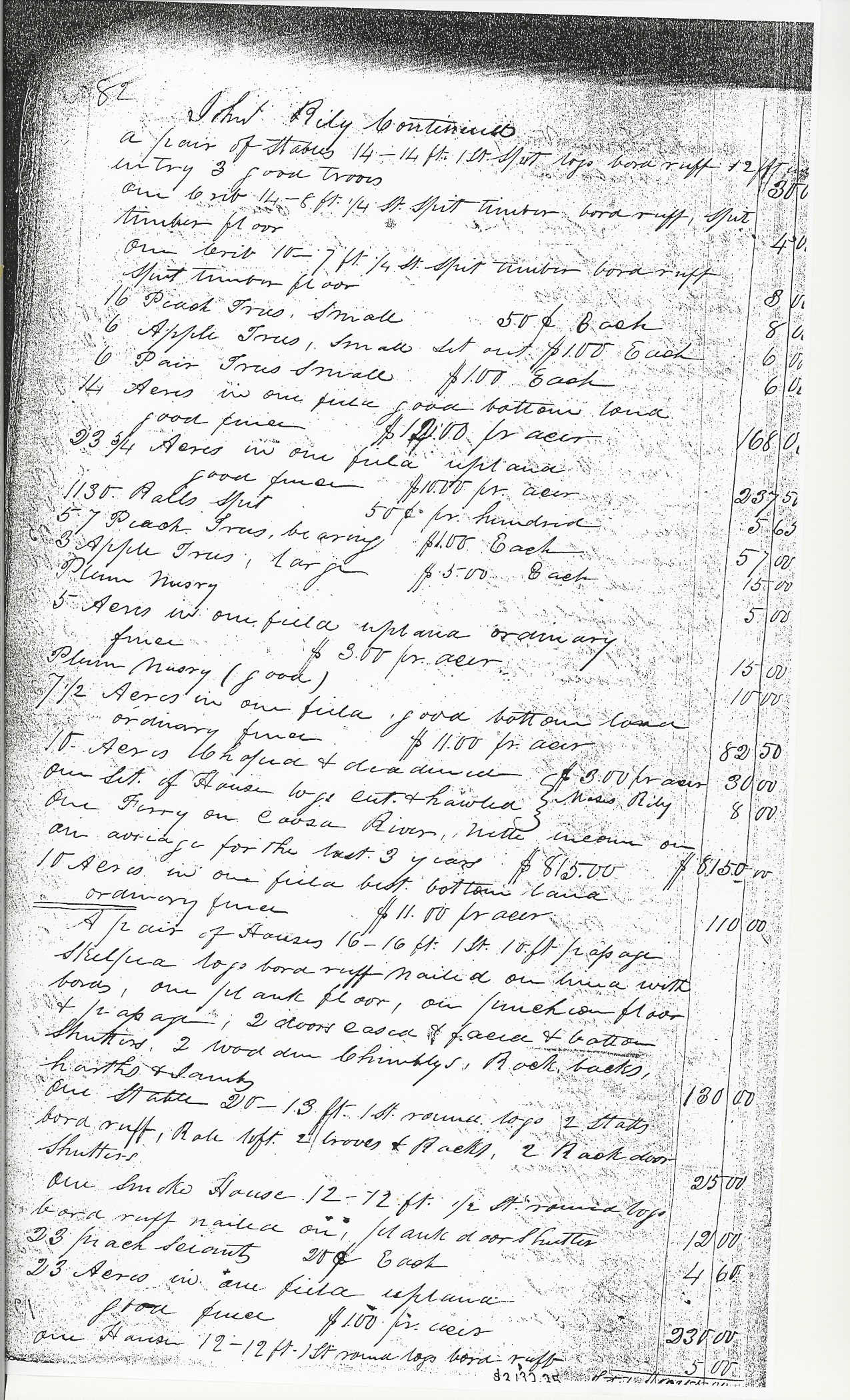
80. Rice and McCoy/Rawlings and Massey’s Valuations, Cherokee County, Alabama, #62; Property Valuations, Entry 224; Records of the Bureau of Indian Affairs, Record Group 75; National Archives Building, Washington, DC. The Ferry was included within Riley’s entire Valuation. It simply noted “One Ferry on Coosa River, nette income on an avridge for the last 3 years $815.00. Amount allowed $8,150.00.” ↩︎
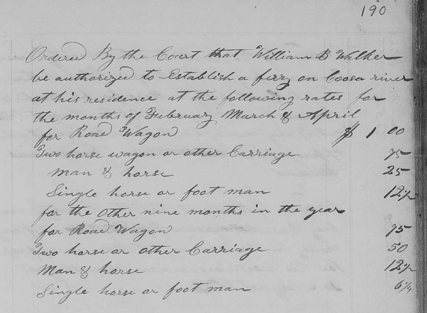
81 John Riley’s Claim dated December 17, 1836. Folder of John Riley; Miscellaneous Claims Papers, 1836-1839, of the First Board of Cherokee Commissioners, Entry 236; Records of the Bureau of Indian Affairs, Record Group 75; National Archives Building, Washington DC. The Folder of also contains an affidavit dated October 7, 1837 from George W. Walker affirming Riley’s Claim. It is not known what George Walker’s relationship was to William B. Walker. The Folder also contains a statement from Hezekiah Oden dated December 11, 1837 that refers to Walker as Capt. William B. Walker. See also St Clair County Court Minutes Book (1828-1834) page 190 where during the August 1832 Term it is recorded “Ordered by the Court that William B. Walker be authorized to Establish a ferry on Coosa river at his residence at the following rates….” ↩︎
82 Ibid. Riley wrote a letter to General Nathaniel Smith on Feb 14 about the loss of the rent. Commissioner Kennedy issued his opinion on May 7, 1838 disallowing any payment for loss of income. ↩︎
83 John Riley Claim. Tahlequah District Claim #194. Folder 815. John Ross Collection. The Thomas Gilcrease Institute of American History and Art (a/k/a Gilcrease Museum), Tulsa OK. “Curtailment on spoliation Claim for a Ferry on the Coosa River, after passing the Cherokee Committee while setting on Claims at the Cherokee Agency in 1838. Curtailed by the U. States Commissioners.” ↩︎
84 Susannah Riley Claim. Tahlequah District Claim #167. Folder 808. John Ross Collection. The Thomas Gilcrease Institute of American History and Art (a/k/a Gilcrease Museum), Tulsa OK. John Riley’s wife, Susannah, was white and her maiden name was Walker. It is not known if there was any familial relationship between her and any of these white men named Walker. ↩︎
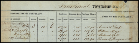
86. Bureau of Land Management, General Land Office Records, Eastern States Office, Springfield, VA. Pre-emption Certificate #6,072 for James S. Leeth of Cherokee County Alabama issued May 1, 1845 for fractions “A” and “B” of fractional Section 3 in Township 12 of Range 6 East. Pre-emption Certificate #6,359 for William Boyd of Benton County Alabama issued May 1, 1846 for fraction “C” and the south part of the southeast quarter of fractional Section 3 of Township 12 in Range 6. Pre-emption Certificate #6,811 for William Tillison and Francis M. Tillison, assignees of Thomas Hollingsworth (as tenants in common) issued June 1, 1845 for the northwest fractional quarter and the fraction “D” of fractional Section 3 in the fractional Township 12 of Range 6 East. All in the District of Lands subject to Sale at Lebanon Alabama. http://www.glorecords.blm.gov/PatentSearch/↩︎
87 Claim #958 (Heirs of John Riley vs. the United States) is not extant; Claims Papers, 1846-1847, of the Fourth Board of Cherokee Commissioners, Entry 250; Records of the Bureau of Indian Affairs, Record Group 75; National Archives Building, Washington DC. See Fourth Board Minute Docket 2 page 71; Minutes of the Fourth Board of Cherokee Commissioners, Entry 249; Records of the Bureau of Indian Affairs, Record Group 75; National Archives Building, Washington, DC. ↩︎
A Little Book About Gadsden, Alabama. Written and Published by the Department of Archives and History of the Woman’s Club of Gadsden, 1938. Page 14-15, 18 , Gadsden Public Library, Gadsden, Alabama. ↩︎
Survey of Township 12 South of Range 6 East, of the Huntsville (AL) Meridian, fraction north of Wills Creek and the Old Cherokee Boundary Line. Plat certified June 10, 1840 by James W. Weakley, Surveyor General of the public lands in Alabama. Jonathan M. Cunningham, Deputy Surveyor. http://www.glorecords.blm.gov/SurveySearch/ Lables add by the writer. ↩︎
Trust in the Lord with all your heart, and do not rely on your own understanding; in all your ways know him, and he will make your paths straight. Proverbs 3: 5-6 CSV
Almost all the old historians of Gadsden state that John Riley built the house he lived in. They state that Gabriel Hughes purchased it from him about 1840. A Post Office was established called Double Springs. The earliest of these histories is a book at the Gadsden Public Library titled A Little Book About Gadsden, Alabama. Written and Published by the Department of Archives and History of the Woman’s Club of Gadsden, 1938. This book seems to be the base of all the histories that followed. On page 14-15 they state;
In 1836 there stood at Double Springs a story and a half log house, built by half breed Indian John Riley. Here, from Huntsville on its way to Rome Georgia, the stage coach stopped and delivered the mail. The Postmaster, William Walker, had purchased the house from the Indian. When young Gabriel Highes arried here in 1840 he bought the log house and settled in it with his wife, Asenath Young Hughes, and his brother, Joseph.1
The book does have several errors. In 1938, they were working with the information they had. This has that Riley sold his house to William B. Walker. Walker sold it to Gabriel Hughes. John Riley stated he was not paid for his houses and improvements (three farms). He listed these in Turkey Town Valley. (See Claims posted earlier). So no one bought it from Riley.
There are no stagecoach routes recorded in historic documents. Postal routes and road improvement are recorded. (I will share those that deal with this location later). Today, we have the digital world of information to sort through. We did look at who built this house, which is probably not John Riley. What can we prove? This house is set in Township 12, Range 6, Section 4, SE 1/4 of the NE 1/4. Did Leath buy this from the US Government? Or, did Gabriel Hughes buy it? Or did these people just move into “free stuff”? (No one bought it from the Indians.)
Map section from the website of the US Bureau of Land Management General Land Office Records, Survey 1839. Plotting added from the Track book images for sections 3 and 4, Township 12, Range 6.
It appears that John C. Leeth owns the property where John Riley’s house is located. Leeth stated he had the property by 1838. John Riley is on the transportation pay list. He is set to move to the west on his own. This move is scheduled during the months of May through October, 1838. See the earlier post. Riley is not on any of the detachment lists on the Trail of Tears.
John C. Leeth is on the 1840 census at or near this location. His brother James bought the A and B fractions on the East side of the Coosa River. His son Ranburn bought the NW 1/2 of the NW 1/4 by 1851. John C. Leath moved sometime before 1850 to Turkeytown between Dr. John C. White and Stephen R. Hood. Today, this is just north of the intersection of Broken Arrow Drive and US 411. John Leath’s son Ranburn will move to the Turkeytown location as well.2 None of our early historians speaks of the Leeth family. John Riley does not speak of Leeth or Hughes.
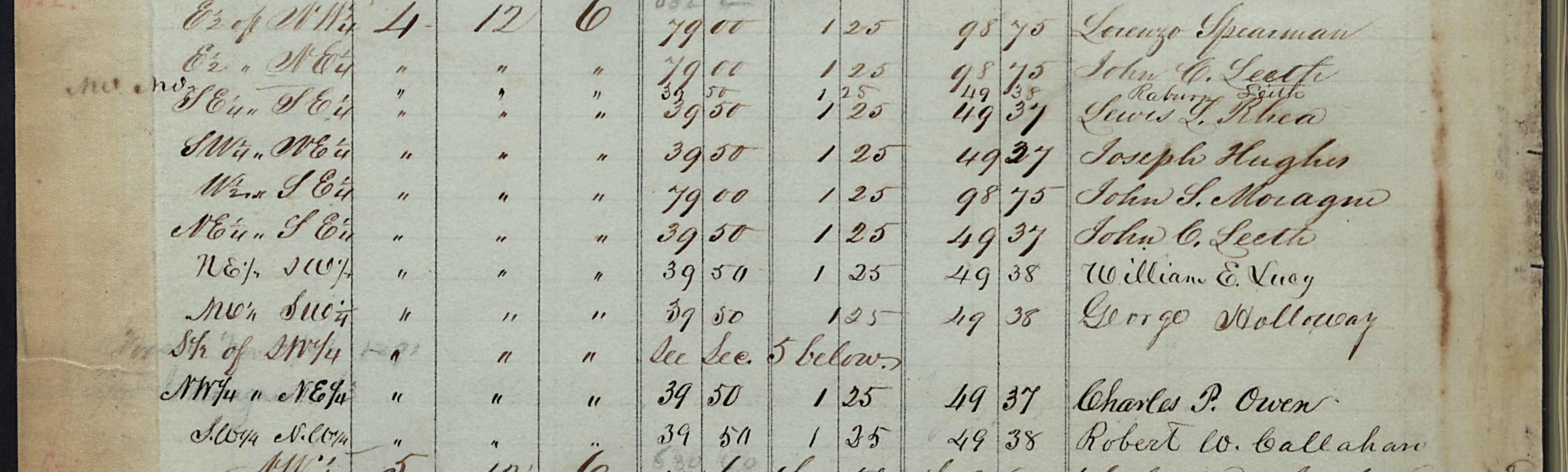
The following is from the Track book of the Bureau of Land Management General Land Office Records’ website. These are the listings of the original purchasers of the property.
Click on the images to bring them up larger. The left column on the second image of each section contains notes. These notes show when the buyer has taken possession of the property. PE ’38 is Pre-Exemption 1838. John C. Leeth, Gabriel Hughes, and Joseph Hughes state 1838. But notice that Gabriel Hughes’ purchase is west of the John Riley house. Notice that Joseph Hughes’ purchase is South of the John Riley house. Of note is that the price is $1.25 per acre. Gabriel and Joseph Hughes have someone buying for them. Joseph’s purchases are the closest to the Riley house. It is all called Double Springs.
Questions
What does this have to do with the history of Turkey’s Town and Gadsden? If John C. Leeth is in the house before Gabriel Hughes then it changes the history. That would be important if I were a descendant of John C. Leeth. Double Springs Post Office. Who bought what? What happened to William B. Walker? The Etowah Abstract Company just might have the answer to “who bought the Riley house from the US Government”. We also need to explore the “ferry.” It plays a part in the history of the founding of the City of Gadsden. Postal routes and the ferry.
John Riley and his farms are notable to the history of New Seneca Turkey’s Town, and the City of Gadsden.
A Little Book About Gadsden, Alabama. Written and Published by the Department of Archives and History of the Woman’s Club of Gadsden, 1938. Page 14-15 , Gadsden Public Library, Gadsden, Alabama. ↩︎
Documented from US Census Records 1850, 1860, 1870, 1880, and 1900. Cherokee and Etowah County, Alabama, John Clark Leath family page. John Clark Leath Male 1801 – after 1880 LQR4-QF1 FamilySearch https://www.familysearch.org/en/tree/person/details/LQR4-QF1↩︎
Trust in the Lord with all your heart, and do not rely on your own understanding; in all your ways know him, and he will make your paths straight. Proverbs 3: 5-6 CSV
John Riley is a notable person of Turkey’s Town. He was half Cherokee and half white. I am not going to go into his genealogy. This post will focus on his involvement in his farms. These farms will be known as the Double Springs, Turkey Town Valley, Cherokee County, Alabama. How it became Gadsden, Alabama.
There are several written histories of the City of Gadsden. All stating that John Riley’s house was the first house of Gadsden and that Gabriel Hughes purchased it. His son Joseph R. Hughes was the first white child to be born in Gadsden. The location of his house is at the intersection of North 3rd Street/Tuscaloosa Avenue/Reservoir Street/Ewing Ave. The house faced Tuscaloosa Avenue. At this location was the first Post Office of Gadsden.1 It was known as Double Springs and was established on 28 January 1833. The Postmaster is William B. Walker. The post office originally was in St Clair County.2 Cherokee County was established in January 1836.
The Postal records have William B. Walker as Postmaster, 1833. Is he living in John Riley’s house? John Riley is operating a “stand” out of his house. L.V. Bierce, in his journal, does not mention paying a toll to cross Black Creek. He does mention the “stand”. This was in 1823. A stand is a stop for travelers.
April 4. Struck our tent and went sixteen miles to Rileys stand, two miles farther and crossed Black Creek, a deep muddy, sluggish stream that takes its name from the tenge the earth gives the water. Three miles from Black Creek we encamped. 21 ml3
“Toal (Toll) Bridge”
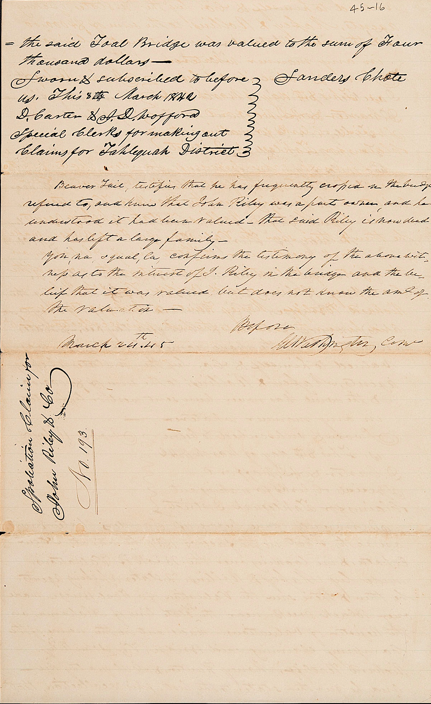
4 Did you notice that the note added from Beaver Tail stated that John Riley had died? Dated March 1845. He died between 1842 and 1845.
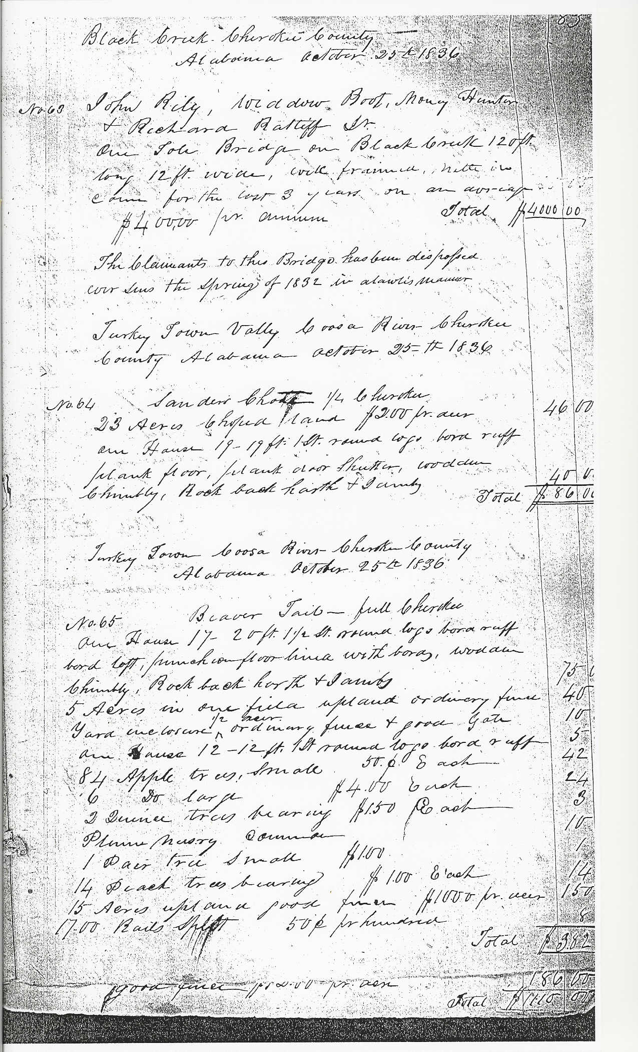
The above claim was made by John Riley in 1842. It is from Tahlequah District Claim #193 dated March 8, 1842. It provides a lot of information. The Toal (Toll) Bridge is 2 miles from his residence. It is over Black Creek. The “Stand” as stated by Beirce is 2 miles from Black Creek. (I have driven from the intersection to Black Creek on Tuscaloosa Ave, it is 2 miles today.)The “Stand” is John Riley’s residence. So William B. Walker is the Postmaster at the time the PO is established. He may be living in one of Riley’s houses. Yet, he is most likely to have his own on the East side of the Coosa River. (See the Walkers involved with the ferry and other property on the Coosa in the claim with the ferry). Riley has 3 farms with several houses, the toll bridge, and a ferry. Walker will have ownership of quite a bit of Riley’s property. This is after Riley leaves for the West. The ferry on the Coosa River will be called Walker’s Ferry. Notice that others are involved with this toll bridge. They are called the “company”. Richard Ratliff, (this is Richard Ratliff Jr., who is married to Chief Pathkiller’s daughter.) Money Crier alias Money Hunter and Cul-qua-tay-kee. Cul-qua-tay-kee was the Cherokee name of Turner, the son of Widow Boot and Boot, the Creek Interpreter for Little Turkey. Boot and Turner were discussed in an earlier post. The Widow Boot is the one originally in the company. She died at Fort Payne during the Trail of Tears 1838. One other outstanding item in the above claim is the value. $4000 is today’s equivalent of $158,108. The next claim shows what else is at the bridge farm.
You can click on the images to make them larger. If you can read cursive writing, they are easy to read. You may have to look up some of the terms. “Puncheon” is a method for flooring made from a log shaved flat by an adze. The stand is one of the houses on one of John Riley’s three farms. These farms stretched from Black Creek to the Coosa River and onto the East side of the river. A line separates the farms listed in the claim.
The Farms
6 In this claim, we see the bridge claim again. This time, the Widow Boot is listed. This is before her death. Also is two orther claims. Sanders Chote is the son-in-law of John Riley. Beaver Tail claim. He is married to the niece of Peggy Pathkiller. They are listed in Peggy’s will.
Is the first farm listed on this claim #62 the house where John Riley lived?
John Riley names some white people by name. One of those is Tapley W. Nawl, who was also involved with trying to obtain parts of Peggy Pathkiller’s estate. The others are difficult to locate and follow.
Notice John Riley has property in Tennessee. He received a reservation below the Hiwassee River. This river empties into the TN River below Knoxville TN. John Riley is from Roan County, TN, which is this location. The area today is Kingston, TN. By these statements, John Riley and his family must have moved to the Double Springs after 1817 but before 1823. L.V. Bierce’s statement from above. The Gabriel Hughes family has a tradition. They noted that a man named Powell lived in the house before Riley. Gabriel Hughes will own the house after William B. Walker. More on this in the next post.
8 Part of the Perspective Map of the City of Gadsden, Alabama 18879
John Riley and his family left on their own for the West sometime between the dates listed above. They were not on the Trail of Tears.
Riley’s house, used as the PO, was purchased by a descendant of Gabriel Hughes. It was disassembled and moved to Whorton’s Bend, Etowah County, Alabama. There, it was reassembled as it would have looked in the 1830s. This happened in the late 1990’s.10
Photo from Messenger, July 3, 2002, Taken by Danny Crownover
Next, we will look at how it became Gadsden, Alabama.
A History of Etowah County, Alabama. Etowah County Centennial Committee, Gadsden Alabama, 1968; Part II, History of Gadsden, written & Compiled By Etowah County Historical Society – Joe Barnes, Coordinator, 1966. Pages 220-241. ↩︎
Appointments of U.S. Postmasters 1832-1971, Volume 11 ca. 1832-44, Saint Clair County, Alabama, Ancestry.com↩︎
Travels in the Southland, 1822-1823, The Journal of Lucians Verus Bierce, page 93 ↩︎
1842 Tahlequah District Claim #193 of John Riley dated March 8, 1842, John Ross Collection, Folder #962, The Thomas Gilcrease Institute of American History and Art (a/k/a Gilcrease Museum), Tulsa OK. ↩︎
1838 Claims made Before Emigration; Book A #242 and Book B #121; Tennessee Cherokee Collection, Box 5, Folders 1 and 2, Microfilm Collection 815, Reel 2, frame 25 and frame 75 respectively. Tennessee State Library and Archives, Nashville, TN. ↩︎
Rice and McCoy/Rawlings and Massey’s Valuations, Cherokee County, Alabama, #62, #63, #64, #65; Property Valuations, Entry 224; Records of the Bureau of Indian Affairs, Record Group 75; National Archives Building, Washington, DC. ↩︎
Tahlequah District Claim #194. Folder 815. John Ross Collection. The Thomas Gilcrease Institute of American History and Art (a/k/a Gilcrease Museum), Tulsa OK. ↩︎
National Archive Microfilm M234 Roll 115, Records of the Bureau of Indian Affairs, Record Group 75; National Archives Building, Washington, DC. ↩︎
Messenger, July 3, 2002, The Vagabond, Vagabonding in Histories and Adventures by Danny Crownover, Returning to Gadsden’s First House↩︎
Trust in the Lord with all your heart, and do not rely on your own understanding; in all your ways know him, and he will make your paths straight. Proverbs 3: 5-6 CSV
Richard Ratliff, Sr was living and had a trading post at Clear Creek and Ratliff Creek (Line Creek). This location is not in Turkey’s Town. It was located at the foot of Raccoon Mountain (Sand Mountain). This is north and west of present-day Attalla, Alabama. But this location is very important to the history of Etowah County, Alabama. Not just because of the Creek Indian War, 1813-1814, that has been earlier discussed. It is the location of the first Post Office in what is now Etowah County, Alabama.
In 1818, Alabama had not been established as a State. Post Office routes were being established throughout the territory. A postal route is discussed by the US Government.
POSTAL ROUTE ADVERTISEMENT — June 20, 1818
#230 From Washington T. by Brown’s Ferry, Fort Ross, Willstown, Ratclift’s, Fort Strother, Fort Lasslie, Fort Williams, and Fort Jackson to Pleasant Level, 285 miles, once a month. 1
Richard Ratliff moved before May of 1820. Another Postal Route discussion by the United States in Congress.
An Act to alter and establish certain post-roads, May 13, 1820
From Cahawba, by Joseph Britton’s, Old Town, Falls of Cahawba, King and Smith’s store, Shelby courthouse, David M’Laughlin’s, St. Clair Courthouse, VINCENT BENNETT’S, the Cherokee Nation, by Ross’s and James Patterson’s, to Washington, in Tennessee. 2
No “Ratliff’s” in the above statement. Now it is “Vincent Bennett’s”. Vincent Bennett is the former Quartermaster for Gen Andrew Jackson during the Creek Indian War, 1818-14. He is listed in the 1820 US Census, Saint Clair County, Alabama. He purchased land from the US Government in Township 12, Range 5 East, Section 7. This is near Clear Creek and Line Creek (Ratliff’s Creek).3
Vincent Bennett established a store at this location. Or, did he take over Richard Ratliff’s after he abandoned it? Bennett’s store is listed as a US Post Office in March of 1822. The Postmaster is Thomas M. Barker. In May of 1823, the Postmaster was Vincent Bennett. August 1823 the name changed to Bennington. Other Postmasters are very significant. Chief John Ross’ brothers-in-law, John G. Ross Postmaster November 1826, Jonathon Mulkey Postmaster January 1828. The name changed to Bennetsville November 1830 and Vincent Bennett is Postmaster.4
As you see sometime between June 1818 and May 1820 Richard Ratliff moved. What happen?
State of Alabama
Resolution For Admission of Alabama into the Union, December, 14, 1819.5 After the State of Alabama was formed, Richard Ratliff, Sr. found himself in the State of Alabama and not in the Cherokee Nation. He moved.
Notice on the above map Bennettsville PO, Ratcliff’s or Line CR, Double Spring PO (Gadsden, Alabama), Turkey Town PO. You also see the resident of John G. Ross. You also see that Ratcliff would have been in Saint Clair County, Alabama. So he moved.
He moved to Turkey’s Town
A location in Turkey’s Town is called Ratliff’s Valley. Not too long after he had moved he was robbed.
Friend &Brother June 24th 1821
On Monday night last there was some white men came to the house of Richrd rattlerif and abused him a Takeing all his children money the sum was nineteen hundred dollars taking from his – of his children money John rattlerif(,) Janeny rattlerfis – this happened near Turkey Town my friend and I want you to assist them To know where this money is gone – when these men come they took him by the throat and beat him on the head and other Takeing the money when any person become old the property the have the exspect it for their children friend Hope you will contrive some way so they may get their money again – I was in hopes the theves was done stealing but they have To steal other ways people that has any thing are fraid sence that they will begain on them I want you to send some letters to the white people that lives in sent cleare county that they may make some search for this money that has been takeing from these people
/s/ pathkiller
the boots
rattleing gard
Tarkahakah
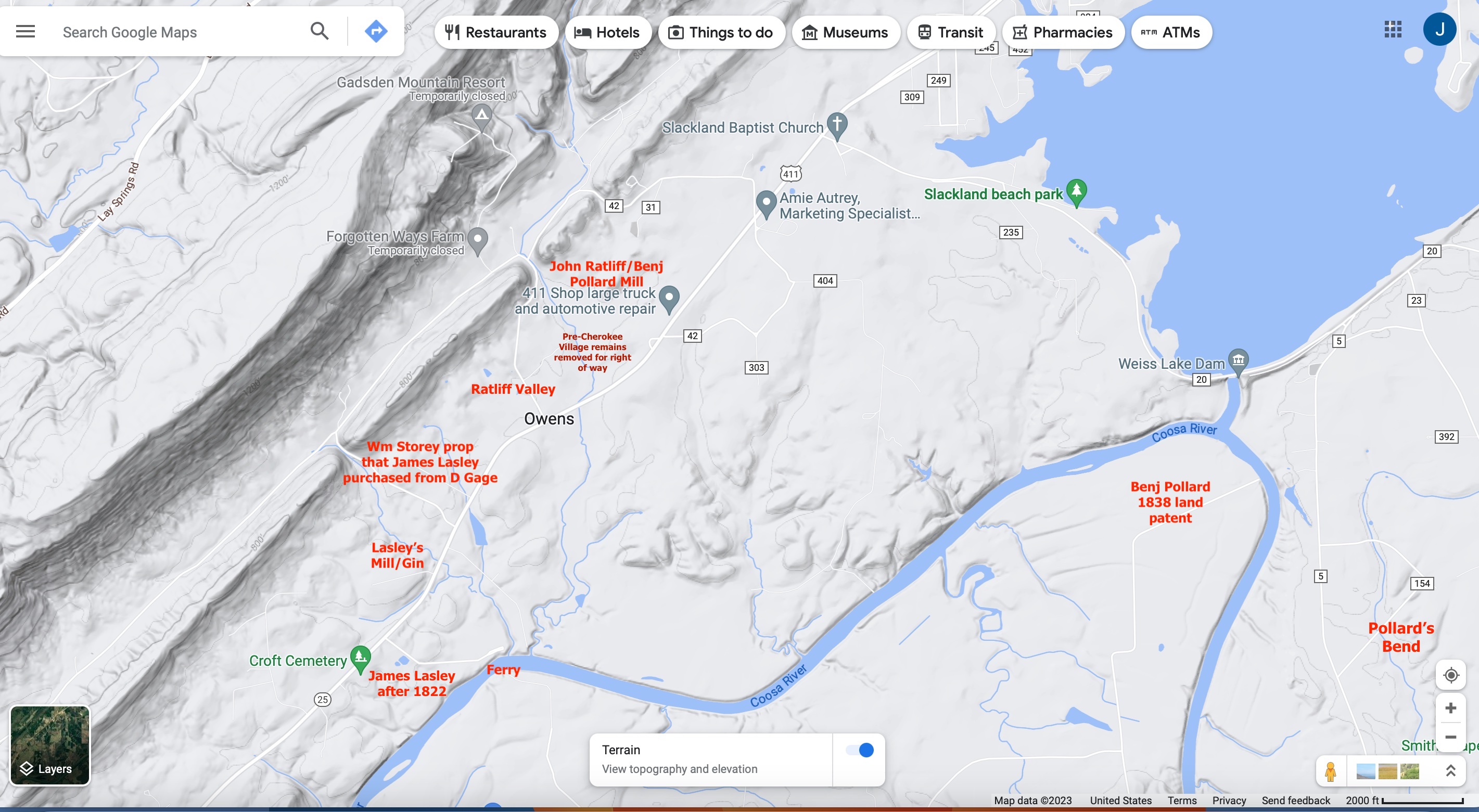
6. Pathkiller to Meigs Google Map, modern, before the new US 411 N four lanes added. Location in red added by Author
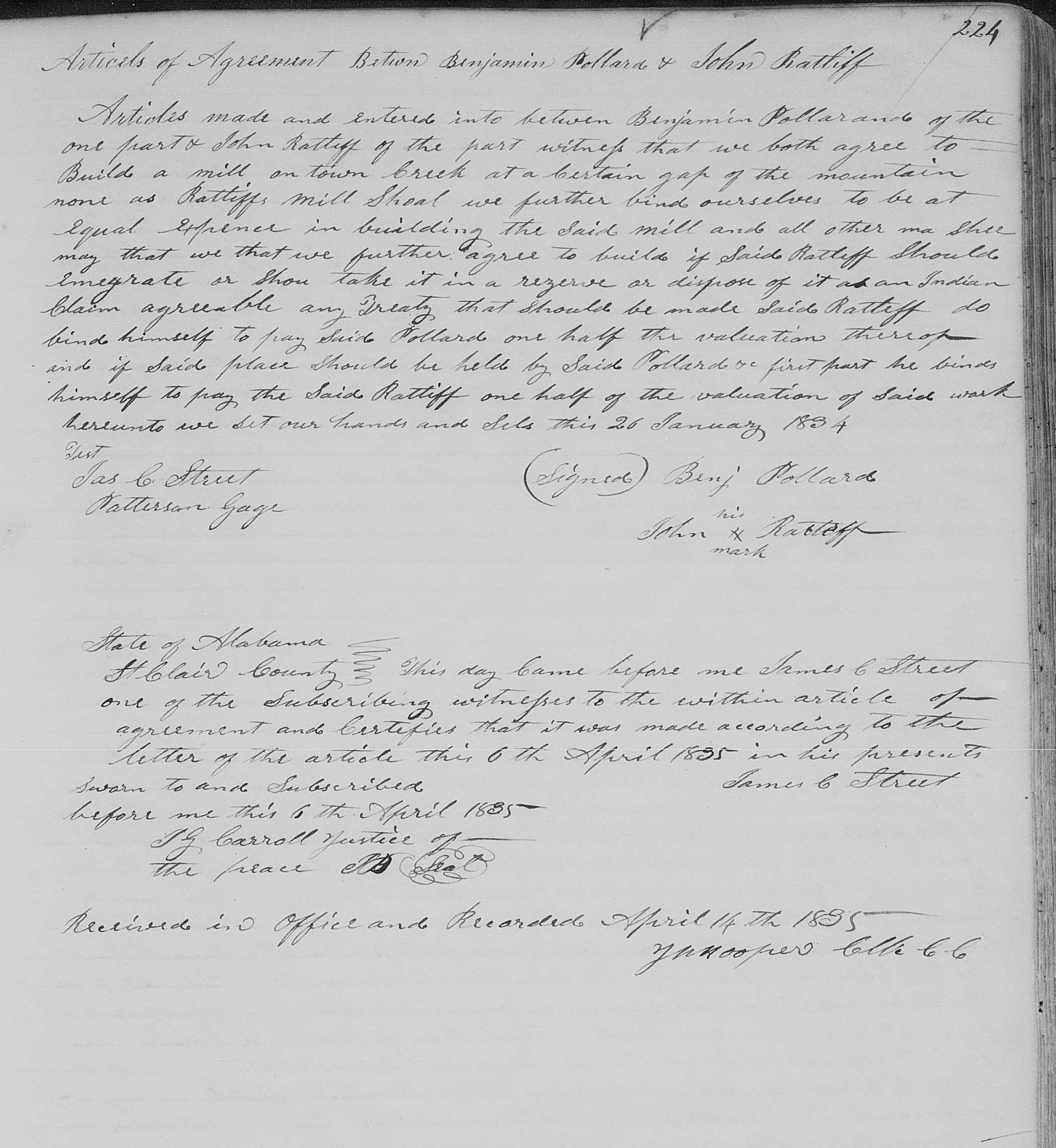
Just where Richard Ratliff Sr. lived is unknown. William Lasley, son of James Lasley called the area Ratliff Valley. It is also referenced in an agreement with Benjamin Pollard and John Ratliff (son of Richard Ratliff Sr.).
There is a lot of misunderstood information on Richard Ratliff Sr. One of them is he died in Turkey’s Town and is buried somewhere there. Find a Grave memorial 59363915 has a lot of information. Parts of this are incorrect. This is the link: https://www.findagrave.com/memorial/59363915/flower Richard Ratliff Sr. did not die in Turkey’s Town. He is on the Lt Edward Deas’ Detachment. This is those removed to the West on the Trail of Tears in June 1838. They left from Ross’ Landing in what is Chattanooga, TN, today. Traveled by boat.9 He is listed above his son Richard Ratliff Jr’s family. Richard Sr family has a male over the age of 50, who has to be him. They are listed as living in Turkey Town. He is also on the Henderson Roll census in 1835, in Turkey Town. He did file a will in Saint Clair County in 1833, gifting slaves to his daughter Janey (Jenny). (They were stolen from her.) He did not die in 1835. His son Richard Jr. is married to Charwahyooca, daughter of Chief Pathkiller and Peggy. They are listed in Peggy’s will.
A portion of page 2 of Lt. Deas’s Detachment Muster Roll, June 1838. 10
Richard Ratliff and family are notable people of Turkey’s Town as well as the State of Alabama.
Correspondence And Miscellaneous Records, M208, Records of the Cherokee Indian Agency in Tennessee, 1801-1835, https://www.fold3.com/image/205695162 Record Group: 75 ↩︎
Last page of a valuation of a claim for William Lasley RG 75, NARA. This property is the William Story property discussed in the James Lasley information. The cove near the Lasley Mill/Gin. ↩︎
Cherokee Registry Trail of Tears-Deas detachment, Cherokeeregistry.com ↩︎
Trust in the Lord with all your heart, and do not rely on your own understanding; in all your ways know him, and he will make your paths straight. Proverbs 3: 5-6 CSV
There are many people named Richard Ratliff who resided in or near Turkey’s Town. There are many stories about Richard Ratliff. I am going to concentrate on Richard Ratliff, who was married to a Cherokee Woman. Richard Ratliff, who moved to Turkey’s Town after he found himself in Alabama and not the Cherokee Nation. Richard Ratliff, who is in an area called Ratliff Valley. Try to answer a question on why he is a “Notable Person” of Turkey’s Town.
First, we find a Richard Ratliff living between Clear Creek and Ratliff Creek. Ratliff Creek is also known as Line Creek due to its proximity to the Alabama-Cherokee border. This area will be on the Cherokee Border in Alabama after it became a State. Alabama became a State in 1819. Richard Ratliff operated a “stand” or trading post at this intersection. The Hightown Path/Creek Path passed by his stand. This path started at Gunter’s Landing on the southernmost point of the Tennessee River. It led to the Double Springs at the Coosa River. Then the Creek Path continues into the Creek land. The Hightown Path takes an east turn to reach Hightown (modern-day Rome, GA). At the Southernmost point of the Tennessee River Fort Deposit was built during the Creek Indian War. This was a supply fort for General Andrew Jackson and the Tennessee Militia. The Path would become the Jackson Military Road.1
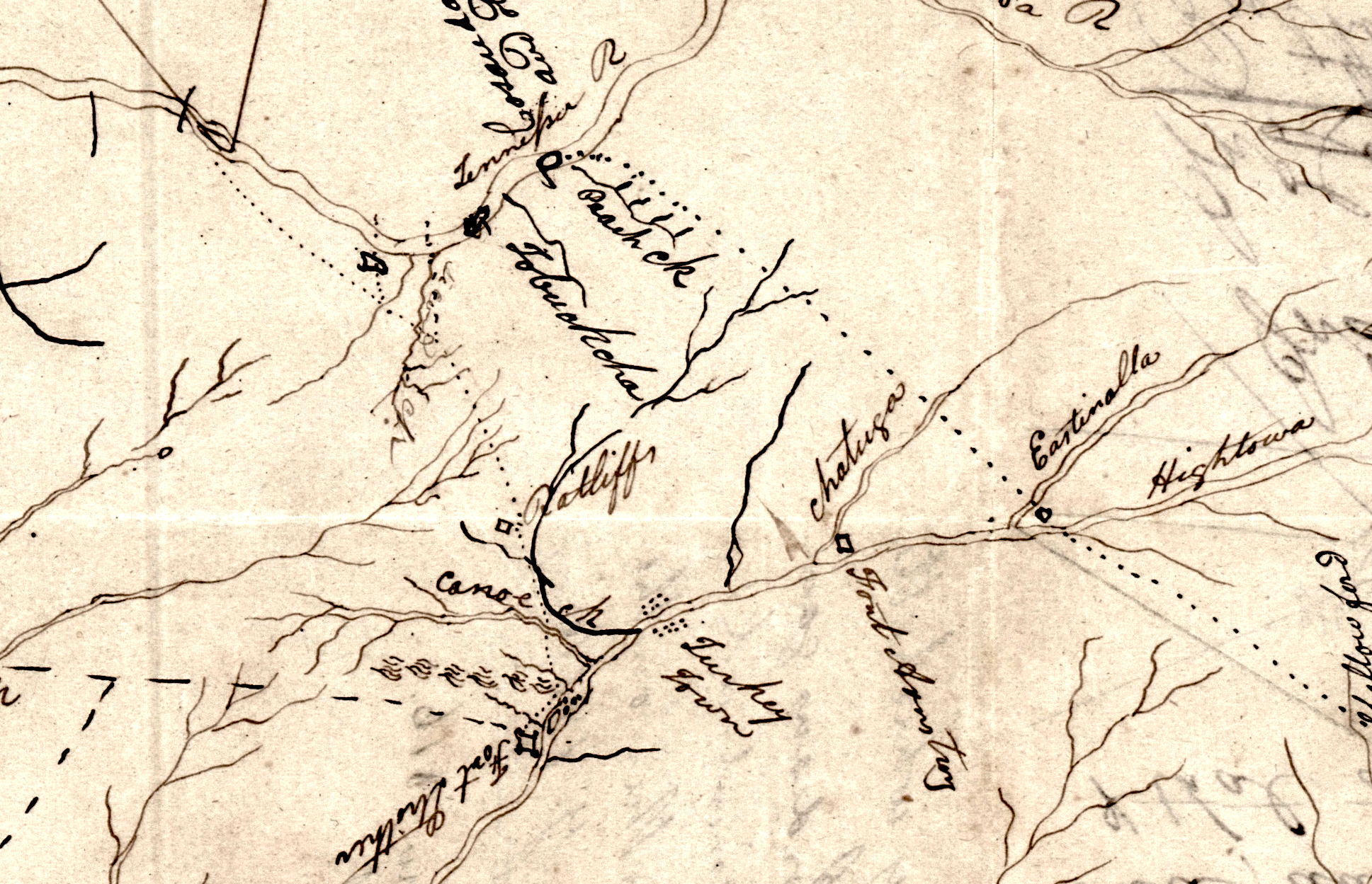
A part of Gen. John Coffee’s map, January 1816. At the far right 3 o’clock position is Hightown. Turkey Town is in the center. North of Turkey Town is plotted Ratliff’s. The stream carved through the R on Ratliff’s is big Will’s Creek. The dotted line crossing the Tennessee River with a square block plot for Fort Deposit. The dotted line traveling south marks Jackson’s military road. 2
We learn a lot from the “Ten Island Three Research team”. Three ladies who researched the Cherokee and Friendly Creek Indians during the Creek Indian War. As well as a study on Fort Strother. These three were Charlotte Hood, Betty Sue McElroy, and Patsy Hanvey. Their work produced a book titled Jackson’s White Plumes.
Chapter2, page 19,
In 1800, Cherokee Captain John Brown and his family, including a new baby daughter, lived in Will’s Valley, not far from Ooe-Asah. Twenty five years later in 1825, Rufus Anderson, of the American Board of Commissioners for Foreign Missions, was inspired to write and publish a book on the life of that little daughter. It was entitled Memoir of Catherine Brown, A Christian Indian of the Cherokee Nation. Anderson’s account stated that “John Brown’s residence in 1800 was within the chartered limits of the state of Alabama … between the Raccoon and Lookout mountains, twenty-five miles south-east of the Tennessee River”. This is where John Brown lived when Catharine Brown was born. The Alabama state line that divided the United States from the Cherokee Nation, Between Raccoon and Lookout Mountain in Will’s Valley, in 1825, was Ratliff’s or Line Creek, near present- day Highway 431 in Etowah County. This places John Brown in the vicinity of today’s Attalla, Alabama, in 1800. There is a branch of Clear Creek, below Ratliff’s or Line Creek, identified as Brown’s Creek. It is 25 miles southeast of the southern bend of the Tennessee River {i.e. present day Guntersville AL}.3
The intersection of the streams and crossroads is important. One could continue south, travel east, or west. This is where Richard Ratliff Sr. lived. We see it plotted on the map above. He encountered David Crockett.
David Crockett
We started and went to a Cherokee town about twenty miles off, and after a short stay there we pushed on to the house of a man by the name of Radcliff. He was a white man, but married to a Creek woman, and lived just in the edge of the Creek nation. He had two sons, large, likely looking fellows, and a great deal of potatoes and corn, and indeed almost everything else to go on, so we fed our horses and got dinner with him, and seemed to be doing mighty well. But he was bad scared all the time. He told us that there had been ten painted warriors at his house only an hour before and if we were discovered there they would kill us and his family with us. I replied to him that my business was to hunt for just such fellows as he had described, and I was determined not to go back until I had done it. Our dinner being over, we saddled up our horses and made ready to start.4
After our meeting we went on the Radcliff’s, where I had been before, while out as a spy; and when I had got there, we found he had hid all his provisions; We also got into the secret, that he was the very rascal who had sent the runner to the Indian camp, with the news that the “red sticks” were crossing at the Ten Island; and that this object was to scare me and my men away, and send us back with a false alarm. To make some atonement for this, we took the old scoundrel’s two big sons with us, and made them serve in the war. We then marched to a place which we called Camp Wills; and here it was that Captain Cannon was promoted to a colonel, and Colonel Coffee was promoted to a general.(November 1813) 5
Crockett thought Ratliff was married to a Creek Woman. Richard Ratliff’s children will tell a different story. He was married to a Cherokee Woman. I will let them tell that story a little later.
Chief Pathkiller’s Complaint to Gen Andrew Jackson
The Path Killer (a principal King of the Cherokee nation) complains to Majr Genl Jackson that a part of the East Tennessee troops on their return home from this place went to John Ratliffs – a half breed Cherokee & took Ratliff & a parcel of his negroes perhaps Twenty & some horses, the number not known – They also took from a cherokee by the name of the Whooping boy eight horses – from one El__ a half breed, they took two horses and a mare & colt from an Indian called the Duck. — The Whooping boy is one of the Cherokee of Dick Browns party, who marched himself to Majr Genl Jacksons army and was in the battles of Tallishatchee & Talladega at the latter place he got wounded & was down with his wounds –6
If any thing could have been proved against old Rattcliff, of any Treason, or hostility …………. I have to request on the receipt of this you will cause old Rattcliff to be liberated, his property returned, and the offenders arrested and punished ……….. Is it not cruel that the whooping boy who fought bravely at Talushatchey and got wounded at the Battle of Talladega – should be plundered, by the east Tennessee troops, whilst confined with his wounds ……To John Cocke from Andrew Jackson.7
John Ratliff, Whooping Boy, and William Ratliff are sons of Richard Ratliff Sr.
John Coffee’s Journal January 1816
10th January (1816) This day traveled to Thompson’s Ferry and lay all night at Capt. Thompson’s. Bill $7.50
11th January Travelled to Young John Brown’s at the foot of the mountain – Lay all night – Paid the bill to amount of $1.50
12th January Travelled to Ratliffe’s – Lay all night
13th January Snowing. We lay all day and night at Ratliffe’s – Paid the bill to amt. $6.50
14th January Set out from Ratliffe’s early in the morning – and arrived at Fort Strother the same evening – Took a house in the old fort and got our supplies from Capt. George Blaik, who resided at the fort with his family.
15th January Reed, who I had engaged as a pack horseman at Ratliffe’s, arrived this day, brought with him a Negro fellow named Jo – The property of Tom Bruner who had been in the Cherokee Nation, and was then on his way home. Sent for Fife.
28th January (1817)….. Crossed Canoe Creek in a canoe and swam the horses – Travelled the road towards Ratliff’s, ten miles, and after traveling in it about five miles struck the road a little sout of the lick ……
29th January A file morning, the first we have had in ten days, statrted early, got to Ratliff’s and bought supplied to carry on, viz ………….. $5.75. Bought a tomahawk at the Old Duck’s – Price $1.008
All of the above are notations from the Creek War 1813-14. It shows that Richard Ratliff Sr. was very involved with Jackson’s army. A notable person. At this time, he lived at what would become the border of the State of Alabama and the Cherokees. Present-day, a few miles north of Attalla, Alabama.
Post the Creek War, why did he move? Where did he move to? The story continues.
Tracing Gen. Andrew Jackson’s Army Across Marshall County, Alabama. A Publication of the Guntersville Historical Society, Tyrus M. Dorman Jr., Editor. Chip Manning, Larry Smith, Danny Maltbie, Pete Sparks, John Oliver Ross. Kindle Direct Publishing. 2025 ↩︎
Jackson’ White Plumes. Charlotte Adams Hood. 1995. Lavender Publishing Company, Bay Minette, Al ↩︎
THE LIFE OF DAVID CROCKETT, The Original Humorist and Irrepressible Backwoodsman. An Autobiography. Chapter 5, page 52. (after the Creeks massacre at Ft Mimms, Aug 31, 1813) ↩︎
Jackson’ White Plumes. Charlotte Adams Hood. 1995. Lavender Publishing Company, Bay Minette, Al. Chapter 6, page 68-73. ↩︎
Trust in the Lord with all your heart, and do not rely on your own understanding; in all your ways know him, and he will make your paths straight. Proverbs 3: 5-6 CSV
James Lasley’s complex or Plantation in Turkey’s Town is quite large. His story is told through Cherokee Claims stored in the National Archives. These records mention James Lasley, who operated a ferry in Turkey’s town. He had on the property a large complex of houses and a cotton gin/mill with a cotton house. There were cribs, a blacksmith shop, and a trading post. He also had slave quarters, stables, several acres of fenced river bottoms, and “uplands.” Extra structures included sheds, a barn, a smokehouse, and a hen house. There was a potato house, a corn crib, and a sheep house. Wagon shelters, a hog house, and apple, pear, plum, and peach trees were also there. He has 250 acres of various sizes of fields, from 50 acres to ½ acre lots, all fenced separately.
There were 5 houses of various sizes, all single stories, made of logs with floors, shutters, doors, and locks. They all had wooden chimneys with rock-backed fireplaces and hearths. The house sizes were 16’x20’ largest to 15’x15’ smallest. There was a block of cabins 36’x13’ with two chimneys, three doors, finished floors, and shutters. The total valuation of this property was listed at $8,223.15 in 1842, with today’s inflation added (2025) this would be valued at $324,885.
Cotton Gin and Mill
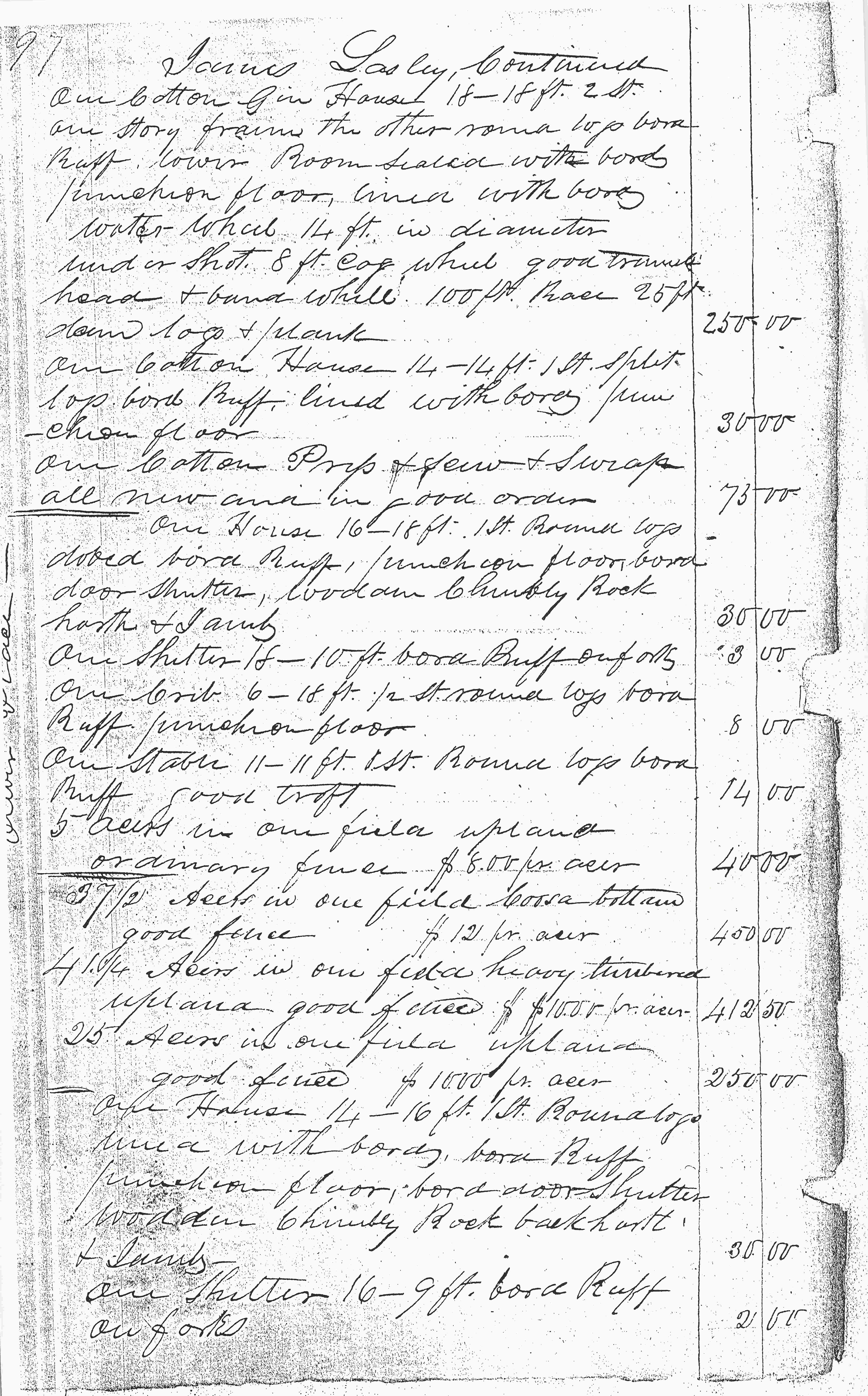
Notable is the description of the cotton gin in the claim. It is stated to be;
One cotton gin House 18’ – 18’ 2 st (stories) one story frame the other normal logs board ruff lower room sealed with board fashion floor mill with board water wheel 14 ft in diameter and in shot 8 ft cage wheel good trunnel head and band wheel 100 ft race 25 ft down logs and planks
One cotton House 14’ – 14 1 st split logs board ruff lined with board fashion floor
One cotton Prep & sew & swas (saws) all new and in good order1
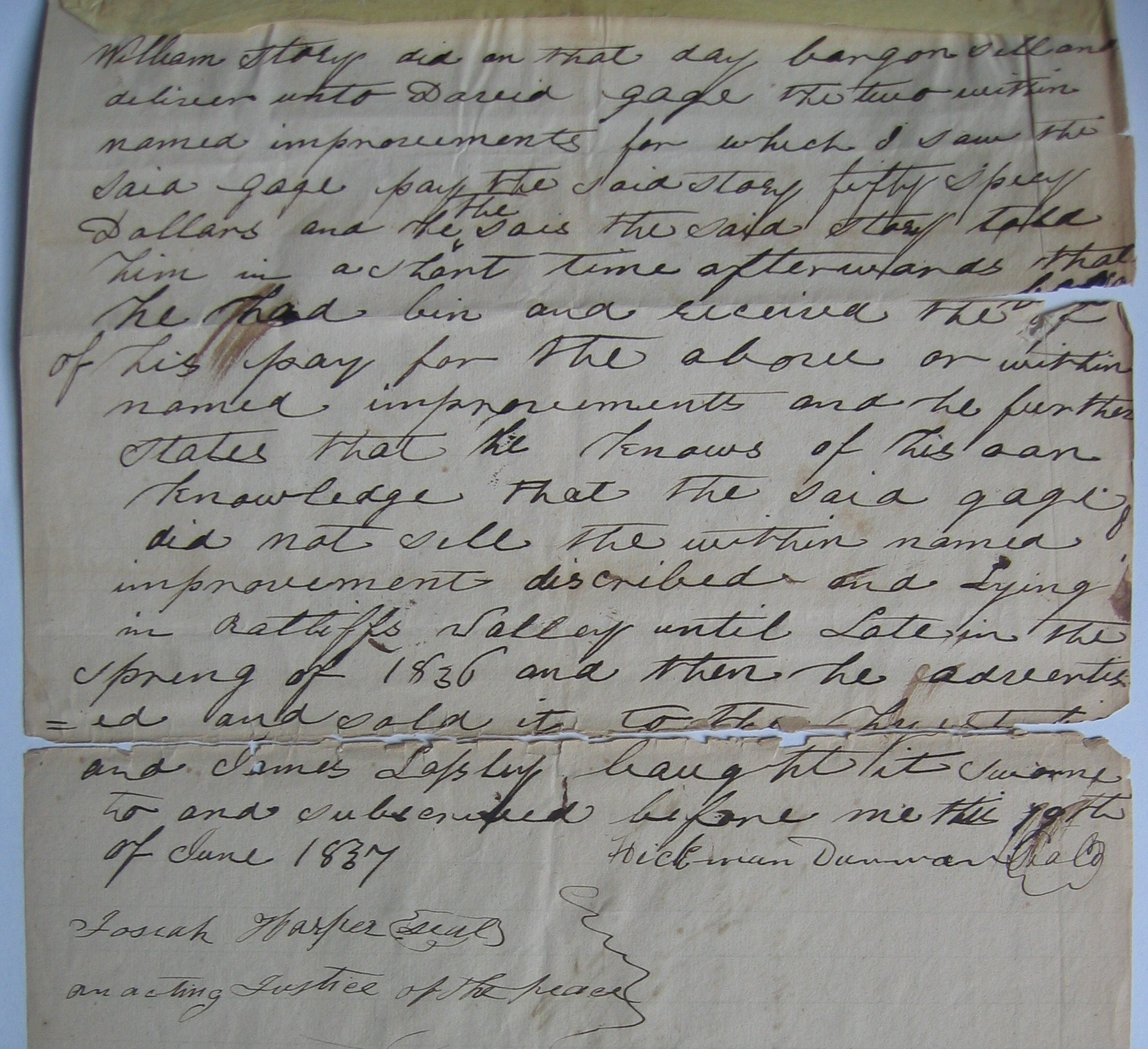
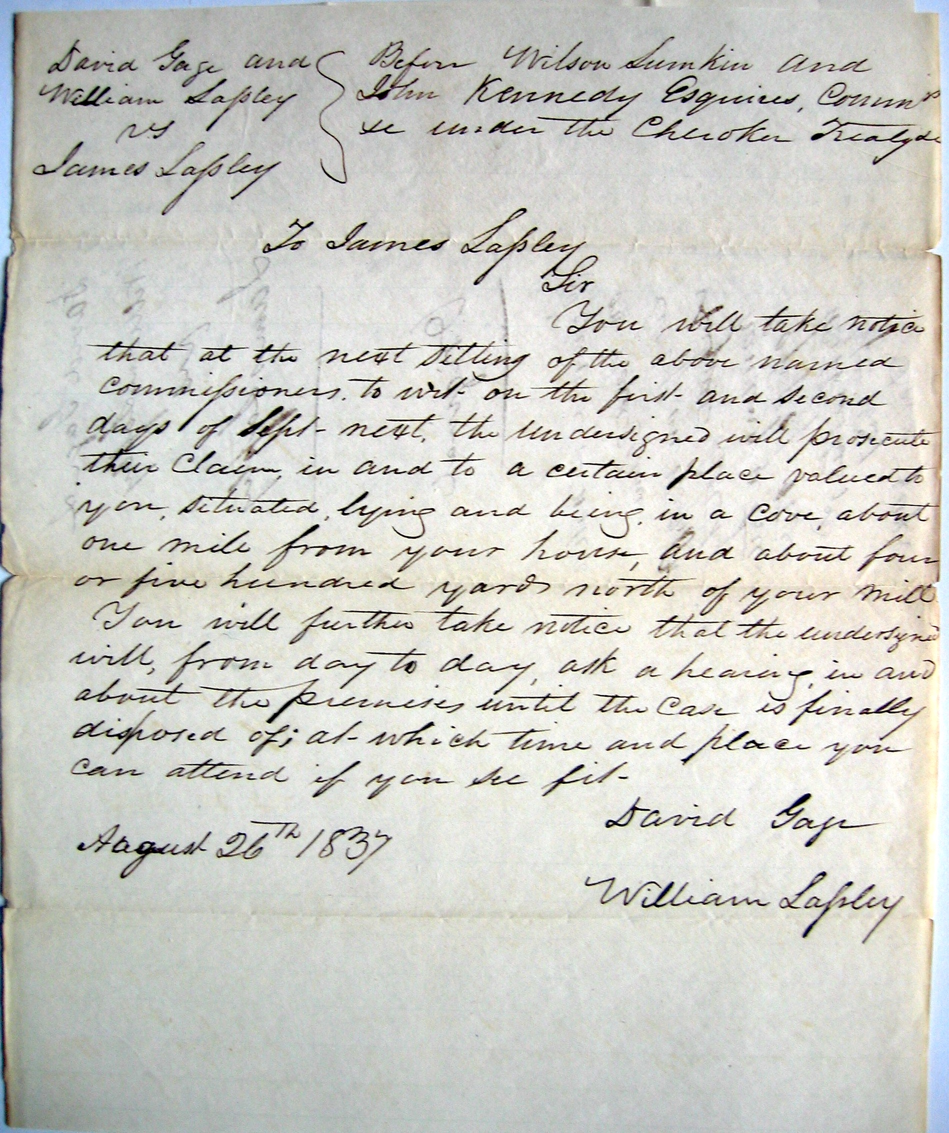
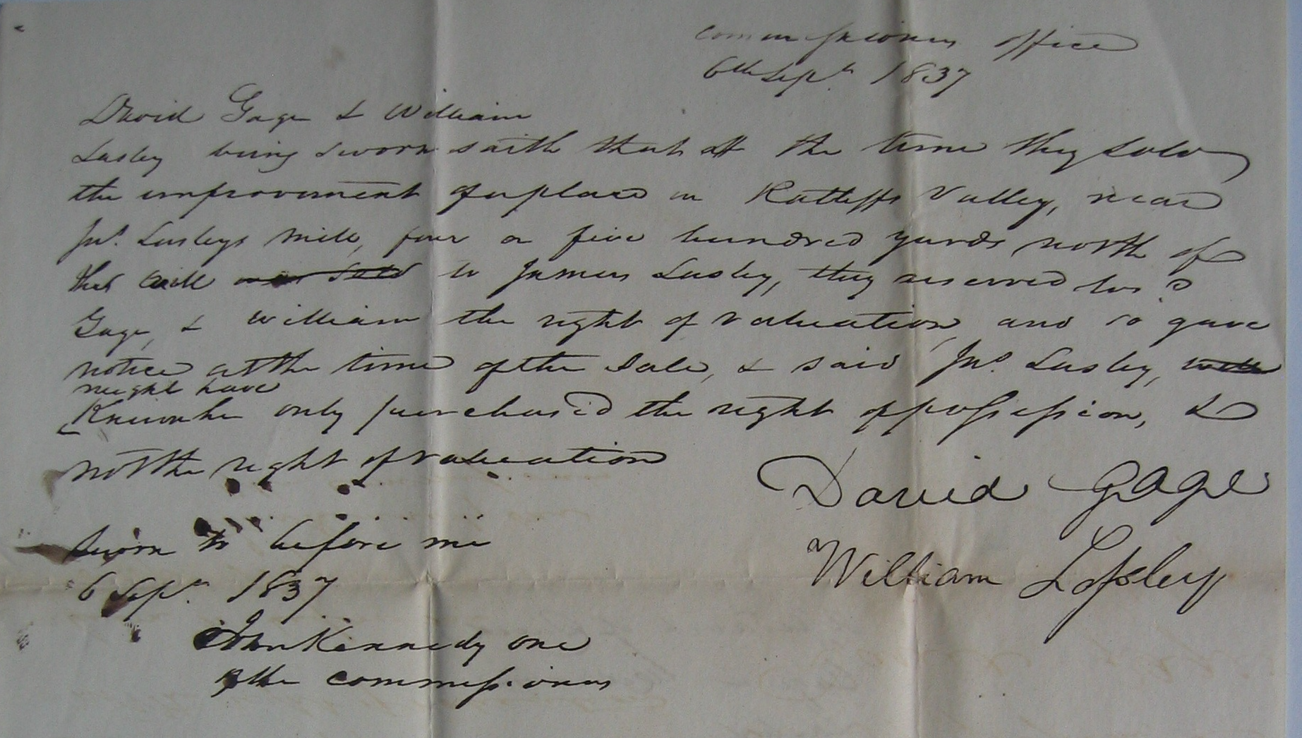
The cotton gin complex was located on the stream coming from Owl’s Hollow. Today, the new US 411 4 lanes cover the location. 500 yards from the cove to US 411 North. Today Spring Avenue off of US 411 North, going into Owl’s Hollow runs parallel to the stream. The stream creates the cove through Shinbone Ridge. The proof is provided in a document for the purchase of two improvements. These two improvements were purchased by David Gage for William Lasley (son of James Lasley) and William Brock. Purchased 26 November 1835. It seems William Lasley and William Brock never paid Gage. (This document is very hard to read.) James Lasley purchased the improvements on 19 June 1837. This will become an issue between father and son.
. . . improvement lying in Ratliff’s Valley about four or five hundred yards north of Lasley’s mill consisting of a dwelling house, smoke house, corn crib, horse lot & one field northeast of said building containing ten acres more of less . . .3
William Lasley went after this improvement. He paid David Gage. Here is the copy of the documents. I wonder who really paid who?
5. This note presents where James Lasley’s house was located. “. . . being in a cove one mile from your house . . ” It is just over one mile to the ferry on the Coosa River. His house was 300 to 400 yards before you get to the ferry landing.6
It is unknown as to the outcome of this. The claim by James Lasley is missing at least two pages. Are these improvements on those pages? We will never know unless those pages are found. They are not with these pages in the National Archives.
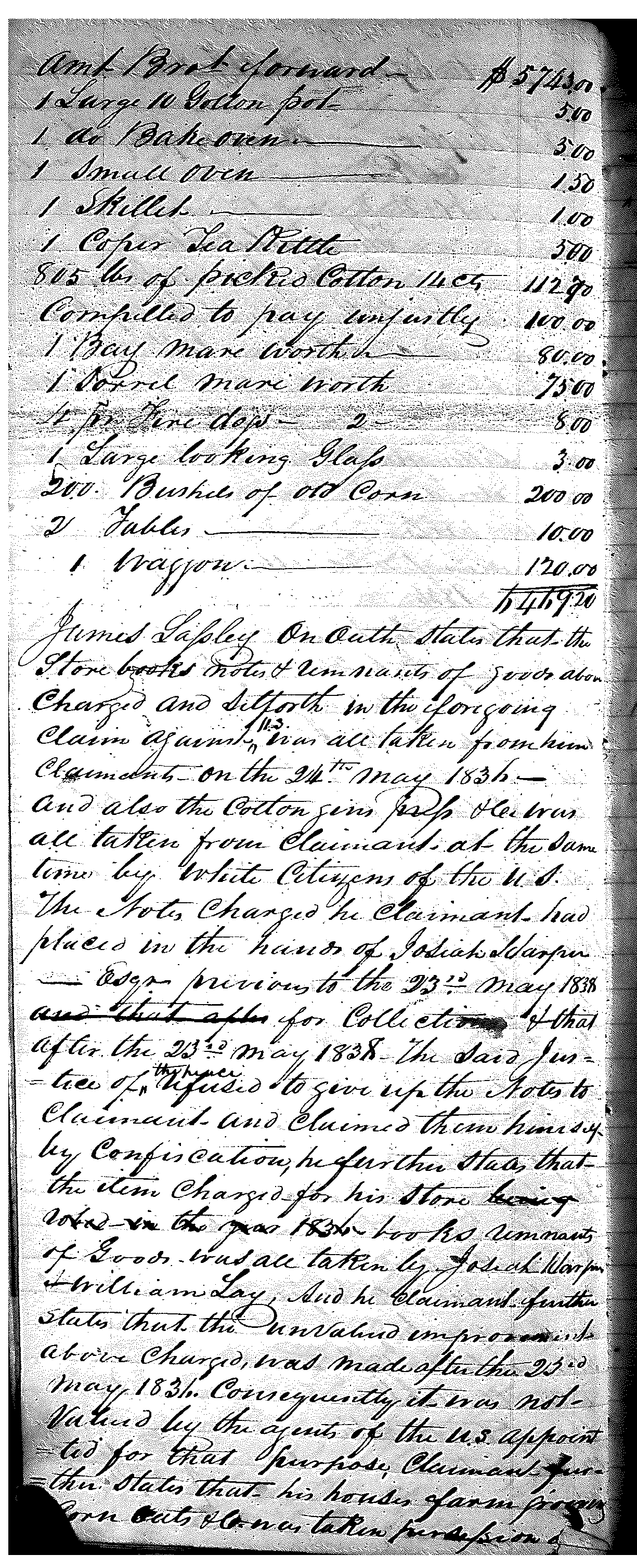
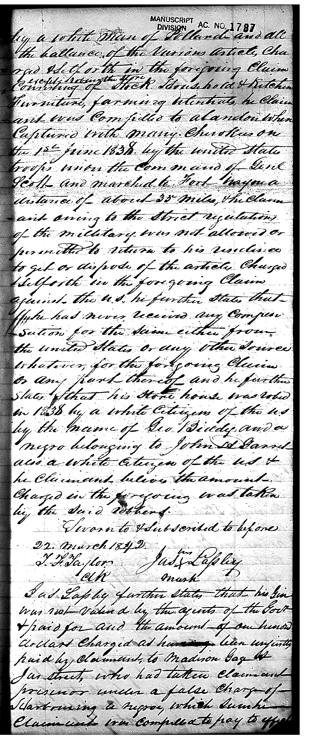
Store Book, Housing Complex
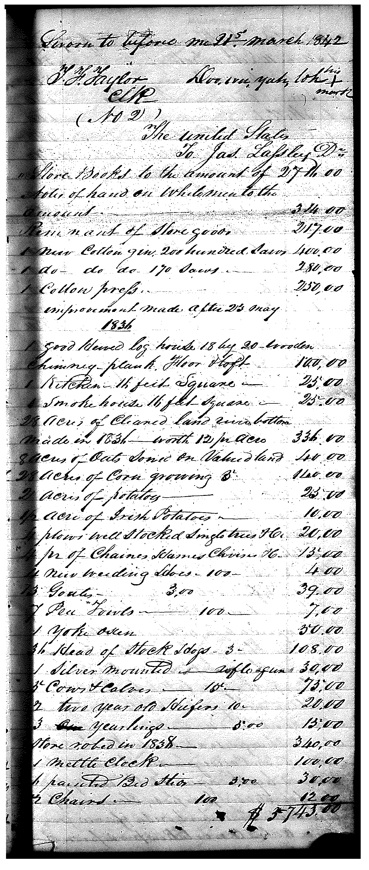
This is the mill and cotton gin complex on the property. The house was near the Coosa River and the ferry. There are a lot of structures involved with the home place. To help us certify the location for this farm and ferry, we can see that Mr. Lasley also filed a claim for his “store books” on the 22nd of March 1842. The store or trading post was near his home, but on the main road.
This claim lists the appraisal amounts for notes owned to Lasley with the store. Has appraisal amounts for the store goods and a new cotton gin. It states improvements made “after 23 May 1836.” On this claim are a house, Kitchen, smokehouse, and 50 acres of cleared river bottom cleared in 1836. It lists other acres of various sizes, stock, and various farm equipment. The total on this claim is $6,469.00. (In 2025 with inflation calculated the claim is $255,585. Total of both claims is $580,470. This does not include the land value.)
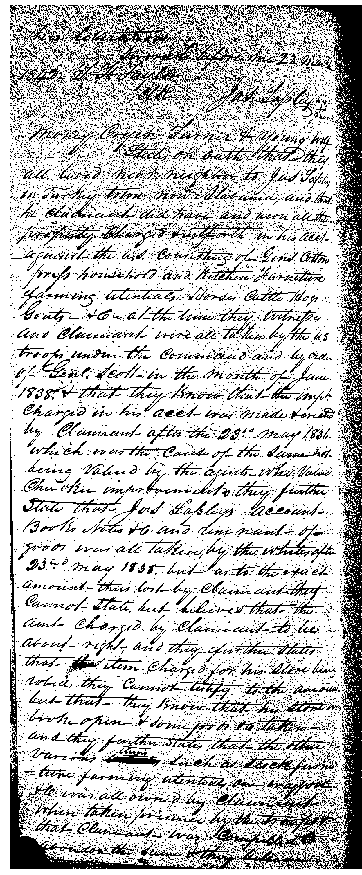
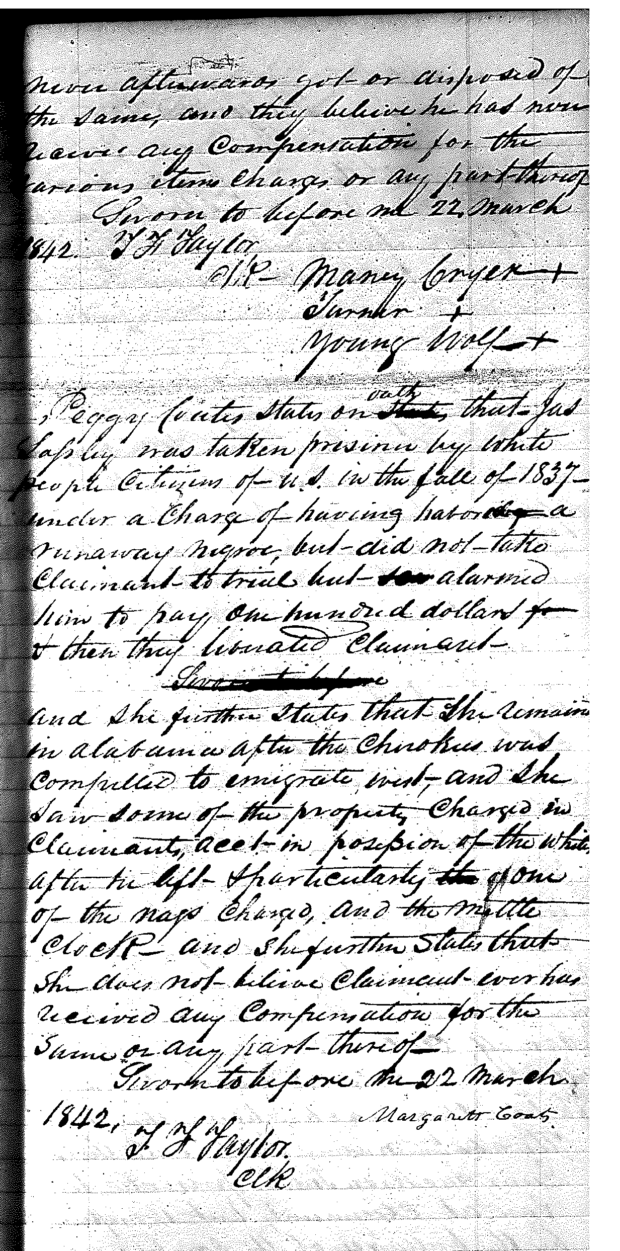
I wanted to post the claim by James Lasley with the witnesses’ notes. This way, you can read them as is. These are in good condition. I know this is cursive dip ink scroll writing. You have to read these closely. He names names. Who are these white men, Josiah Harper, William Lay, Pollard, James Street, John H. Garrett, George Biddy, and Madison Gage? If you read closely, you can find out the exact day that the US troops came to his house. They forcibly marched him and his family to Fort Payne, a stockade. The city of Fort Payne, Alabama, got its name from the stockade. It was the launching point for detachments of the Trail of Tears. The witnesses: Turner, son of Boot. Margaret (Peggy Coats) is James Lasley’s daughter and the wife of Gideon Coats, namesake of Coats’ Bend. More on that in its own post.
I will continue this in the next post on where this is and how we know. I will explain how and what the community is today. This will help explain who the white men are.
Copy of 1842 James Lasley Claim, National Archives, Washington DC, Record Group (RG)75 Bureau of Indian Affairs, Entry (E) #224, Volume 25, pages; 96, 97, 99, 100, Copy from Michael Wren’s personal collection. ↩︎
Copy of 1842 James Lasley Claim, National Archives, Washington DC, Record Group (RG)75 Bureau of Indian Affairs, Entry (E) #224, Volume 25, pages; 96, 97, 99, 100, Copy from Michael Wren’s personal collection ↩︎
Trust in the Lord with all your heart, and do not rely on your own understanding; in all your ways know him, and he will make your paths straight. Proverbs 3: 5-6 CSV
We start a new chapter. This will be about notable people in or of Turkey’s Town. These people will introduce us to tragedy, communities, and cities. Uncovering the history of Turkey’s Town.
The first notable person is Charles. He is the nephew of Chief Pathkiller. The notable part of this is whether justice was served or not. Is the complaint below by Chief Pathkiller about Charles? The clip is from the journal of Rev. Daniel Butrick. He visited Turkey’s Town in January 1822. Charles is Chief Pathkiller’s nephew. Chief Pathkiller’s complaint is about his son. The time frame is perfect. Charles was murdered in April of 1821. In the culture of the Cherokee people, for the male, your sister’s children become yours on her death.
Charles’ story is told by correspondents, including an attorney and a Justice of the Peace in Monroe County, Mississippi. It is told by Chief Pathkiller in his correspondence to the US Indian agents to be forwarded to the U.S. President. A trial was scheduled for January 1822. There are no surviving documents to indicate that it ever took place. In November 1822 Chief Pathkiller complained again about no justice. Again, no follow-up documents. I will try to explain the people as we uncover the information.
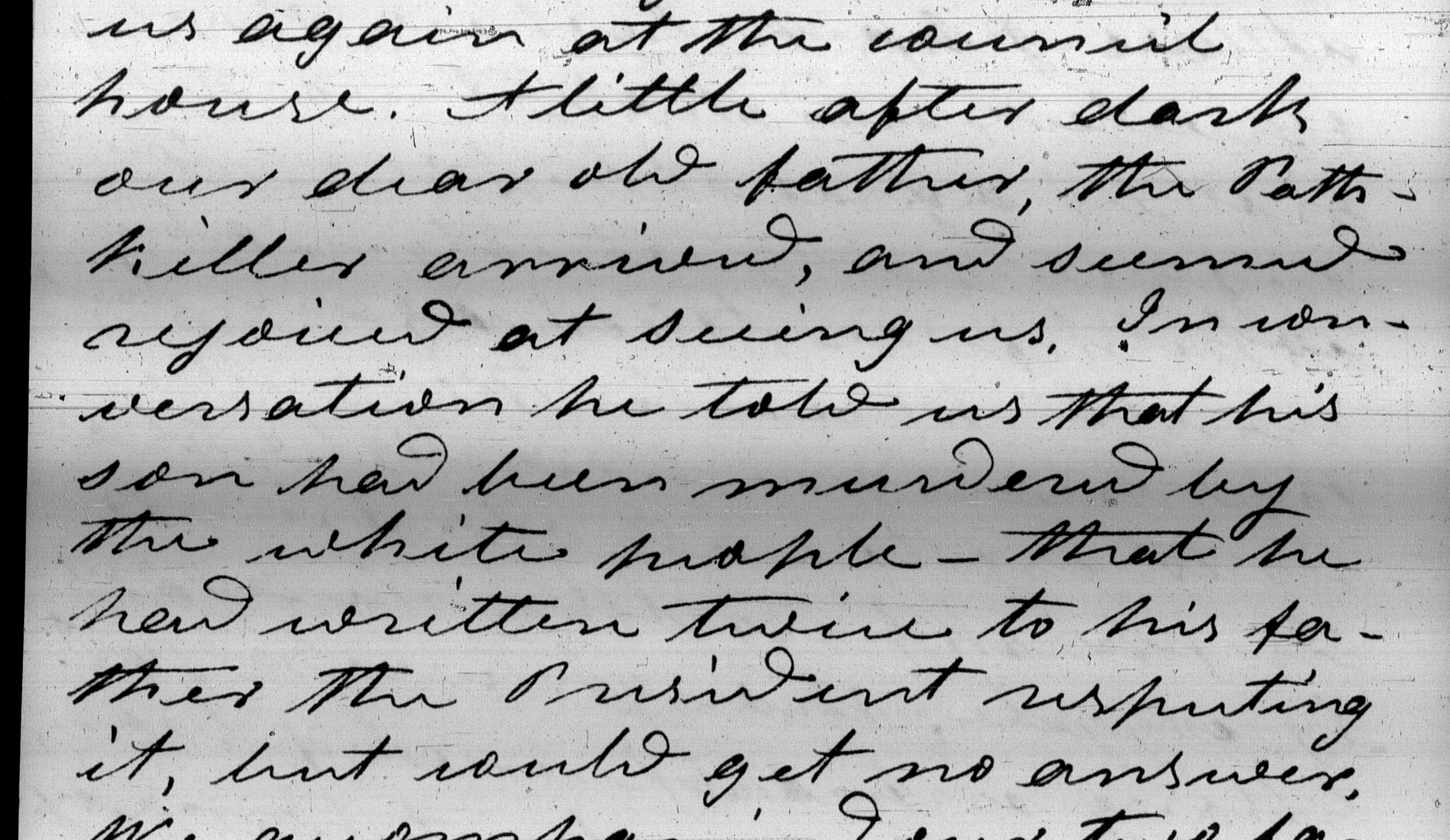
A little after dark our dear old father, the Path-killer arrived, and seemed rejoiced at seeing us. In conversation he told us that his son had been murdered by the white people – that he had written twice to his father the President repeating it, but could get no answer.1
The information below is from the records in the website, FamilySearch. Images noted in the reel. The spelling and punctuation are as recorded.
Turkey Town in council June 24, 1821 To Charles Hicks friend and brother
I will inform you-I see white people every day of all sorts and I treat them with Justice-Since the war we was friendly and I expected we would have mutual friendship, but now they have killed one my people-my nephew charles you must inform our agent, our agent was just where he is to do justice ask him for the murder when our beloved men put him in that place we were To do justic between each other he ought not refused to get the murder because we are less than they are-when any axident happens of that kind they mainly appehanded us whether it is just or not-my nephew was passing in the white country peacible when he was killed-Mr hicks friend I want you To procide in this as you know what to do in this case-if there should be any mistake in this I want you To regulate this and send it on To the agent. this murder was done on the Bigla near the Choctaw Nation we was informed by a man named Meconnal he was there when charldes was killed the man that killed charles by the name of Morris-when you get answer from Col. Meigs I want you to send it on as soon posble my mind is very much disturb when I hear from you mind will be easy-
Turkey Town
Hick Pathkiller the Boot Rattling goard Ta-Ka-ha-keh the frog . ar-me-yal-hak the cow Boy
Note above. Charles Hicks is Chief Charles R. Hicks. He was Chief Pathkiller’s second. The Boot we have discussed. Ta-Ka-ha-keh is Chief Pathkiller’s son. Colonel Meigs is the Cherokee Indian Agent, Return Jonathan Meigs.
Image 119
To James Meigs Esqr Agent of the Cherokee Nation High wasse Garrison
Zekiel Nash and John Halbert Esqrs Letter June 27th 1821 Subject Datailed circumstance of the murder of – Charles A Cherokee who was killed by Gabriel Morris a White man in Monroe County State of Mississippi on the 10th day of April 1821 said Morris is held to bail for his trail in Jany 1822
State of Mississippi Monroe County June the 27th 1821
To the Agent of the Cherokee Indians
Sir. This is to give you notice of the cherokee of the name Charles of Turkeytown. Together with a detail of the accompanying circumstance of unfortunate fail, which accured in this county, on, or about 18 April 1821-on the 23d June 1821, Gabriel Morris the young man that committed this unfortunate fact, came forward before me one of the Justices of Quorum for said County and surrendered himself a prisoner for the killing of said indian Charles, I then called on John Halert a Justice of the Peace for said County, to aid me in the examination of witnesses. We proceeded, confirmed & took down the testimonies of Solomon McCalahan and Robert McElvna both swore, That on the 10th of April 1821. At a store of Joseph Reed they saw the indian Charles on the horse of Gabrile Morris who told him to get off or he would work him off with a pine limb, but Morris did not do so, but only shoved him off and laid down the limb and took hold of the bridle. The indian also took hold of the bridle, Morris pulled it out of his hand. They both stood a while. The indian stuck Morris on the nose with his finger; then immediately drew his tomahawk and struck Morris on the side of the head a sever blow, Morris ran. The indian pursued him. Morris crossed a fence took hold a hand stick or spike, and struck at the indian across the fence the stick flew out of his hand. Morris again ran and called for help he believed the indian would kill him. Morris however got hold of an other stick and threw it at the indian missed him, but he (morris) fell, recovered(image 121)and crossed the fence back again and fell a second time recovered again got hold of the first hand stick and stood, the indian all the while pursuing wih his tomahawk drawn in a hostile manner and rushed on Morris. Morris struck him the indian two blows to the head, the indian fell, Morris struck him one more blow while down—John McCalahan swore to the same part, from the time Morris started to run except hearing him cry for assistance, saw the circumstance from a distance, Henry Hawkins sayeth on his oath the he saw G. Morris running with the indian after him and saw him turn and strike the indian two or three blows over the head he thinks the second brought him down. they all believe Gabrile Morris had received a very dangerous wound from the indian, which cut through his hat and several folds of a silk handkerchief, and fractured his scull bone-
Benjamin Pollard, sayeth on oath that the indian Charles came with him from black creek in the Cherokee nation and that he appeared to behave very well- Joseph Reed, sayeth, on oath, that he saw Charles the indian in a few hours after he recieved the fatal blow. That Dr. J. V. Tibit of Tuscaloosa first dressed his wound, and he Reed kept Charles the indian in his house, and afforded him every necessary assitance until he died, which was eight days afterwards. During which time the indian appeared to be entirely senseless-the (Rreed) had him buried in a decent manner near the place where he died—Thus Sir-After hearing all the evidence, we are of the opinion that the said Gabriel Morris had no other alternative but to kill or be killed, he regret etremly that he was reduced to that dire dilemma. But so it was the blow that he recieved from the indian with the Tomahawk had stuned him, the blood running down his face, and calling for help and no one rendered, we think he is only guilty of jusifiable homicide-But as the right is not in us to determine in the case, and for the satisfaction, friendship & peace of the relations of the said Charles, and the indian of the Cherokee nation, we have taken the said G. Morris in Recognizance to remain in a certain bounds till the first of January next. (1822) to await if necessary the further process of law, We have no circuit court or Jail in this county. You being the proper person to attend to this business, we send you this notice. And further pray you to give us the earliest information, what you think is further necessary to be done in this case the young man (Morris), wishes to be fairly discharged as early as practicable.
yours Respectfully Ezekiel Nash
June 27th 1821. John Halbert J. P.
N. B. About six weeks after Morris received the wound the indian, I saw a piece of the scull that was on that day taken out of his head, where he received the wound,
Ezekiel Nash
James Meigs is Return Jonathan Meigs, the Cherokee Indian Agent. His name was misspelled or misunderstood. Ezekiel Nash is an attorney. John Halbert is the newly appointed Justice of the Peace for the newly formed District V, Monroe County, Mississippi. Monroe County was created from Marion County, Alabama, when the new state line was drawn for Mississippi and Alabama in 1820-1821.3 This is on the Tombigbee River west of the Alabama state line. Benjamin Pollard is a white man living in Turkey’s Town. It is from his and his family’s name for Pollard’s Bend in Cherokee County, Alabama.
Image 124
(Letter 28 June 1821 of Charles Hicks on behalf of John Ross to Col. Return Meigs about several items, one item is as follows)
I have received an express from path Killer with letters to, which is herewith enclosed, on the subject of a white man killing his nephew, Charles, who went off with one Pollard from this nation in the beginning, I believe of 1821 or 1820 in order to go on to some of his relation in the Chickasaw Country, and the express stated, that the informant McConnals was present when Charles was killed by Morris, was at Pollards house, near the Chickasaw Country, and must insist on your best endeavour to have the murderer punished if possible for when any of our people act wrong the nation is threatened to be delt by our neighbours-
Image 135
Return Meigs to Pathkiller & Charles Hicks about the Murder of Charles
Friend & Brother Cherokee Agency 6th July 1821 .
I have received you letter of the 24th June Ultimo, informing of the murder of your Nephew Charles I know of no way for me to act in this case but to Advertise, at the place. where the murder was done and keep a vigilant, look out for the murderer, & if possible trace it to all source I will do all I can to detect the murderer, & I enclose an advertisement of which you can have several coppies made & set up at such place as will probably be best of which place you know better than I do, being unacquainted & with that part of the Country. You must invest yourself, no body can do so well as you in this unhappy case. Besides the Advetisment enclose the form of a complaint to any, or all the Magistrates of Alabama State, for you to make use of, as circumstances shall require-
Respectfully Return J. Meigs
Path Killer Head Chief Head Chiefs C. Nation
Charles Hicks
Image 137 (The copy of the Advertisement of the murder)
Advertisement
Cherokee Agency 6th July 1821.
Whereas a Cherokee named Charles Nephew of the Path Killer was in the month of -June last murdered by a white man in the State of Alabama, and Whereas in case it is very difficult is to detect the murderer the good citizens of that all who of equal justice, influenced by honorable motives it is hoped thay will and the Cherokees in detection the perpetrator of that murder. The Cherokees as Americans have a right to the protection of our laws & it is not doubted they will receive it in the State of Alabama by having the aid of us-Citizens W Return Meigs
Image 164
Chief Pathkiller’s response to Agent Meigs through John Ross.
Cheroker Nation
Friend and & Brother Nov 13th 1821.
I have seen and heard the content of the papers you have enclosed to Mr. Hick & myself relating to the circumstances and proceedings of the unhappy event, in which my nephew Charles fell a victim to the hands of Gabriel Morris a Whiteman in the County of Monroe & State of Mississippi this unfortunate affair forces to my mind the several similar events which have heretofore befallen Cherokee. The reflection is painful more particularly so, because equal justice have seldom ever been extended towards them in such cases, as they have been whitemen.-You are ready to say that I am suspicious or prejudicial -is not so. You have recomended to me to pursue & to use all exertion to apprehend the late murderer. This I would unhesitatingly do, provide he was within the bound of this nation-But what chance of prospect would there be for Indians to pursue and to apprehend a white(image 165)man in the white settlements? I answer none but indian persuers more to be taken up or kill themselves by the white Magistrates in their letter giving you notice of the unfortunate affair, justly observed, that the right is not in us to determine in this case & for the satisfaction friendship and peace of the relations of Charles & the Indians of the Cherokee Nation. We have taken the said G. Morris reconnaissance to remain in a certain bounds till the first of January 1822 to wait if necessary the futher process of law, you being the proper person to attend to this business C & C now call on the U. States agent for this nation and make known to you that is my request in behalf myself & the relatives of the said Charles & for the satisfaction of the Cherokee Nation, that you proceed without delayed to have the said Morris prosecuted and broght before a proper Court trial-should your health and situation be such as to prevent you attending personally to the prosecution of the said Morris send you assistant and interpreter in your place from and direct them to call on me on their way down. I will send some Cherokees with them to attend the trial, in case I do not go myself-I hope you will not delay in the business and you will not fail to send the subagent & interpreter to prosecute the Murderer-
I am your friend & Brother
Done in the presence of John Ross
Path Killer mark
Principal Chief Cherokee Nation
John Ross at this time period is the President of the Cherokee National Council.4 He will become the Principal Chief in 1828.
Image 443
John Ross his letter of the 25th November 1822.
Complaining of not further enquiry into the Death of Charles Cherokee, having been killed in Alabama by a white man named Gabriel Morris in a quarrel about the 20th April 1821. In that quarrel said Morris had his skull fractured a part of the scull bone taken out six weeks after the quarrel. It appears by abundant testimony that sd Charles was the aggressor.
Image 444
To Col R J Meigs Cherokee agent
Rossville Cherokee Nation Nov. 25th 1822 R –
Brother it is now twelve months since I wrote to you from this place, the subject was a painful one to me, and it is no less so now to be compelled to send it at this late period- you will recollect that an unfortuate circumstance had taken place in the State of Alabama, which deprive me of an only Nephew from the papers you transmitted to me it appeared that the good people of the State apprehended bound over to Court for procution whose hands my nephew became a victim, and that in my communication to as above alluded to. I had very earnestly solicited you to repair yourself, or to send your deputy to prosecute the Murderer & that myself & other Cherokees would accompany you o the deputy and attend his trail-since that time I have never heard a word from you on the subject. It is true the death of the Murderer would not restore to life my past departed Nephew(image 445)but have it was as little as you could have done to prosecuted the murderer in a Court of justice agreebly to the stipulations of our treaties-It is truly grievous to me to see so much indifference or relaxation on the part of the agent of the U. States indering ample justic to the propersion of blood Cherokees for which have been spilled by the hand of the White People on the of the Cherokee, on all occasion have they coplied with their obligation-the whites have so frequently spilled the blood of the red man with impunity & indefience of justice that some of them do boast, that they can kill an indian without hazarding their own lives for haveing done so,-Brother this is a hand and gauling bravado which the poor Redman is compelled to brook. It does truly appear to me that the obligations on the part of the U. States, have been considered by the Agents of Government whose duty it is enforce them, as a mere matter of form to appear the minds of the ignorant red people, so as to compel them on to their part to yield to the utmost rigor of you laws, Brother I cannot dissemble with – your attention in this unhappy affair is truely mortiying to my feelings & I cannot avoid expressing my dissatisfaction-I cannot believe that the Government of the States are disposed to administer two sorts of justice, one for the benefit of their own citizens & the other for the distruction of the red people, consequently there must neglect & inattention from some other quarter.-I have always treated my white Brethren with the utmost friendship, from the highest character to the lowest vagabond when they call on my house & chance to be drunk & use unbecoming words I make no difference in the friendly treatment, believing that they could not behave to, had they been sober. Brother had the fate of my Nephew befallen a dog, less indifference could not have been manifested than in the death of my nephew. I have the right to expect justice thro the medium(image 446)of your exections as an agent for this nation therefore I must request you to inform me whether you have or intend prosecutionf the murderer before a court of justice so that a fair tral may determine his fate-If nothing cannot or will not be done in this unhappy affair I trust that you will be candid enough to let me know without delay had you proceeded in the affair as I had a right to expect form you my mind would have been released from the unpleasant feelings which it still bears on the subject. Brother you cannot think my earnest request in this affair, unreasonable, if you take the subject on you own side-I whish to hear from you as soon as practicable, I hold you fast by the hand as a Brother & will not let you go until I am snatched away by the strong arms of death.
done in my presence, John Ross
Path Killer or Nanohetahee his mark
Conclusion
There was no response from President James Madison about this matter. Did he know? Was it passed up the chain of command? There is no response from the Government of Mississippi. Governor George Poindexter’s term ended in December 1821. Governor Walter Leak’s term started in January 1822. Agent Meigs died in the year of 1823. There does not seem to be any follow-up on the requests of Chief Pathkiller.
So the question again would be, what makes this notable to place it here in the history of Turkey’s Town? Did the outcome influence the decisions of John Ross in the coming years? Was Chief Pathkiller’s confidence and trust in the United States’ agents affected by the lack of response? Review the last two letters to Agent Meigs. I believe this is John Ross’s concern as well as Chief Pathkiller’s concern over the relations between the two nations.
22 Jan 1822, Journal of Reverend Daniel S. Butrick, pages 41-46, American Board of Commissioners for Foreign Mission (ABCFM), 18.3.1 V4, Michael Wren’s personal copy. Original and transposed copy. ↩︎
Eaton, Rachel Caroline. John Ross and the Cherokee Indians. Menasha, Wis., George Banta Publishing Company, 1914, page 35, image 55, https://www.loc.gov/item/14018822/↩︎