
Tags
alabama-history, cherokee, cherokee-county, cherokee-indians, etowah-county, history, indigenous, native-american, native-americans, New Seneca, northeast-alabama, northeast-alabama-history, trail-of-tears, turkey-town, turkeytown
“The Southern Indians . . .the records of their history are records by whites and are marred by prejudices and misunderstandings . . .” R. S. Cotterill, The Southern Indian, Preface.
Traditional histories
Traditional histories of white people create confusion about the location. Let’s look at the statements about 3 different places for Turkey’s Town. I will explain the timeline for establishment in its own post later.
Location one.
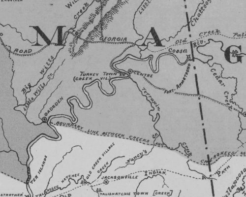
One mile south of the town of Centre on the west side of the Coosa.
August 7, 1936; Cardon’s History Cherokee. Front page, Coosa River News, first column five paragraphs down;
“Turkey Town was established some time prior to 1770, and was one of the most important of Cherokee establishments. It is here that Col. Campbell, the noted British soldier and superintendent, lived at times during and after the Revolutionary War. Turkey Town was located about one mile from Centre on the west side of the Coosa River, not far from the mouth of Terrapin Creek. This fact is attested to by all of the authorities on the subject, and is shown on a half a dozen maps owned by the writer, dating from 1817 to 1835. The old Indian Trail or ‘Creek Path’ running from Creek Path Town, now Guntersville, crossed the river at Turkey Town, where after the turn of the 19th Century, Pathkiller, King of the Cherokee, operated a ferry.”1
Mr. Cardon does not give a citation except for “all of the authorities.” He would also cite C. C. Royce’s 1884 Map. The information on the location did it come from James Mooney and Royce’s map? Did it come from the Alabama Historical Society?
James Mooney’s book Myths of The Cherokee and Sacred Formulas of the Cherokees states;
Gun’-di’-gaduhun’yi (abbreviated Gun’digadu’hun)- “Turkey’s settlement” (gu’nu’, turkey), so called from the chief, Turkey or the Little Turkey, upon the west bank of Coosa river, opposite the present Center, in Cherokee county, Alabama.2
Charles C. Royce served with the Bureau of Indian Affairs and Ethnology. He was an author and businessman. He confused people with his placement of Turkey’s Town on his “Land Cession Map” by calling it a “Creek” Village.3 https://www.geographicus.com/P/ctgy&Category_Code=roycecharlesc
This created confusion in a report to the Governor of the state of Alabama. The Governor of Alabama requested a report from the Historical Commission. It was printed on December 1, 1900, and copyrighted in 1921. The report provides two Turkey Towns, both at the same location.4
Page 418; Creek Indian Town and Villages, Chapter IV;
Turkey Town, an Upper Creek Village, is marked on Royce’s map (1884) on the western shore Coosa River opposite the influx of Terrapin Creek, from the Southeast and also opposite the recent town of Centre.
Page 420; Chapter V Cherokee Towns and Villages in Alabama;
Turkey Town. Founded about 1770, and situated in the bend of the Coosa river opposite the town of Centre in Cherokee County. It was a place of great importance in the Nation and was named for one of its most noted Chiefs “The Turkey”, here under this chief’s lead originated many of hostile expeditions against the white settlers of Tennessee and Kentucky. -see Pickets History of Alabama Vol. 1 page 163.
These notations in this 1900 report are the sources for Mr. Cardon and historians later.
A reference noted above; see Pickets History of Alabama Vol. 1, page 163. This reference does not give any information on the location of Turkey’s town.
Albert Pickett’s “History of Alabama and incidentally of Georgia and Mississippi, from the earliest period”. On page 163 Mr. Pickett writes;
Will’s Town and Turkey Town—important Cherokee establish. The former was named for a half breed called Red-headed Will. At these towns lived the British Superintendent, (the celebrated Col. Campbell,) before and during the Revolutionary War. . .
Cherokee County History written by Mrs. Margaret Stewart repeats these notes. 1956 Cherokee County History Volume 1, page 204;
“Turkey Town named for noted Chief “The Turkey” and located in the bend of the Coosa River opposite to and one mile south of the town of Centre. It was founded about 1770, and was considerable size and importance. It is marked on the Royce’s Map (1884) opposite the influx of Terrapin Creek. Chief Turkey lived on the east side of Turkey Creek on what later became the Sims farm. By some Indian agents and traders, the town was called New Seneca.”
page 214;
“Turkey Town was established some time prior to 1770 and was one of the most important Cherokee establishments. Col. Campbell the noted British soldier and superintendent lived here at times during the Revolution. Turkey Town was located one mile from Centre on the west side of the Coosa not far from the mouth of Terrapin Creek. The old Indian Trail or Creek Path crossed the river at Turkey Town, and Pathkiller had a ferry here.”5
Location two.
Turkey’s Town from Gadsden to Centre, Alabama.
Another location for the town is described in a History of Etowah County, Alabama. During the centennial of Etowah County Alabama in 1968 a committee was formed to write a history of the county. “History of Etowah County Alabama; Part I, A History of Etowah County, Alabama by Elbert L. Watson.”6
page 9, Chapter I, Etowah County; An Ancient Homeland;
Chief Little Turkey and his followers located their village, Turkey’s Town, along the northern bank of the Coosa River in an extremely fertile and productive area of the Coosa Valley. Actually, Turkey’s Town, or Turkeytown, as it was later called, was more an area instead of a village, since it extended from just south of Centre to below Gadsden where the Coosa River and Big Wills Creek formed the Cherokee boundary line.
The third location.
99.1 percent underwater of Weiss Lake in the area of LIttle River, Chattooga River, Coosa River.
A third location was noted in 1993. The Turkeytown Association of Cherokee held an Intertribal “Pow Wow” next door to Gaston High School, Etowah County, Alabama. Cherokee County Herald September 15, 1993, the front-page headline is; “Cherokee Indians celebrate at the wrong place? Alabama historian and researcher Don Naylor says YES”; written by the editor Paul W. Dale. He states;
“Turkeytown is actually located some miles from where the festival organizers have laid claim to a site they contend is where a Pow wow was held some 150 years ago. The truth is the truth and you cannot bend it.” Naylor is listed as a historian that researcher who primarily hunts Creek Indian history and artifacts throughout the Cherokee County area. “Turkeytown is now 99.1 percent under water of Weiss Lake.” Bob Minnix of the Cherokee County Historical Museum in Centre. “Turkeytown is actually located in the area of Little River, Chattooga, Coosa.”7
(As of note, I was a board member of the Turkeytown Association of the Cherokee. This was an educational group to promote Cherokee and Turkeytown history.)
If you look at Wikipedia, you will get all three locations.
Much of the original site of Turkeytown is now underwater, due to the impoundment of the Coosa River which formed Weiss Lake. The present-day community of Turkey Town in Etowah County, Alabama is fewer than ten miles southwest of Centre, Alabama and near the original site of the town.
https://en.wikipedia.org/wiki/Turkeytown_(Cherokee_town)
Oliver Day Street “The Indians of Marshall County Alabama”;
About 1777, Wills’ Town was established by the Cherokee. . .about the same time Turkey Town was built by them on the Coosa river opposite the present site of Centre, Cherokee County, Alabama.
(reference is “Pickett’s History of Alabama”, vol I, page 163; Royce in the 5th Annual Report Bureau of Ethnology, Map 8) 8
Mr. Street’s statements are like those of many other local histories and state historians who repeat the same information.
Conclusion
So, where is the original site for Turkey’s Town? With the above, there is no conclusion. With the above, there is confusion. Three locations? Spread from today’s Gadsden to Centre, Alabama?
The correct location is where? Where is this noted “Sim’s farm, east of the creek”? Where Chief Turkey lived. Are all the places part of Turkey’s Town?
What do the Cherokee people say? What do the people who interacted with Cherokee people in Dah-noo-wey-ye say about the location?
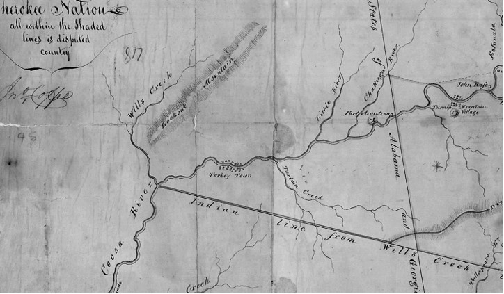
Next time, we will start looking at those sources. Till then, study Gen. John Coffee’s map.9 Compare it to Royce’s map above.
- “Coosa River News”: Friday 7 August 1936: Page 2: Gadsden Public Library, Genealogical and History Library: Microfilm. ↩︎
- Myths of The Cherokee and Sacred Formulas of the Cherokees by James Mooney from the 19th and 7th Annual Reports B. A. E. published in 1900 and reproduced 1982, page 521, “Glossary of Cherokee Words. ↩︎
- Map of the former territorial limits of the Cherokee “Nation of Indians;” Map showing the territory originally assigned Cherokee “Nation of Indians.” Published 1884, author C.C. Royce. Library of Congress. ↩︎
- Publication of the Alabama Historical Society Miscellaneous Collection: “Report of the Alabama Historical Commission to the Governor of the State of Alabama December 1, 1900”: Edited by Thomas McAdory Owens, Chairman: Montgomery Alabama: 1901: Google Books eBook: Public Domain. ↩︎
- “Cherokee County History 1836-1956 Volume 1”: Mrs. Frank Ross Stewart: Centre, Alabama:1956. Gadsden Public Library. ↩︎
- “A History of Etowah County, Alabama”: 1968: Etowah County Centennial Committee: Woodrow J. Stephens, Joe Barnes, Jerry B. Jones, Juanita Miller, and Elbert L. Watson; Gadsden, Alabama: Roberts and Son: Birmingham, Alabama. Copy in possession of the writer. ↩︎
- “Cherokee County Herald September 15, 1993”: Editor Paul W. Dale: Front page: Copy in possession of the writer. ↩︎
- “The Alabama Historical Society, Montgomery, Alabama, Reprint No. 8”: XII The Indians of Marshall County, Alabama, Montgomery, Alabama, 1904, page 206: Oliver Day Street, Guntersville, Alabama: Google Books eBook: page 185. ↩︎
- A piece of the map, Sketch of the Disputed Country Between the State of Georgia and the
Cherokee Nation. Record Group 75, Records of the Bureau of Indian Affairs, 1793-1999, Series,
Central Map Files, 1824-1962, National Archives Catalog, General John Coffee. ↩︎
Trust in the Lord with all your heart, and do not rely on your own understanding;
in all your ways know him, and he will make your paths straight. Proverbs 3: 5-6 CSV
