• Home
  • About
  • Alabama Chapter Trail of Tears Association
  • National Trail of Tears Association
  • Local History

New Seneca Turkey's Town

~ Uncovering the History of Turkeystown, a Cherokee Village/Town in Northeast Alabama

New Seneca Turkey's Town

Tag Archives: native-american

The Beloved Chiefs From Turkey’s Town, Chief Pathkiller

20 Tuesday May 2025

Posted by Jeffrey Sauls in Local History

≈ Leave a comment

Tags

alabama-history, cherokee-indians, native-american, northeast-alabama-history, Pathkiller, trail-of-tears, turkeytown

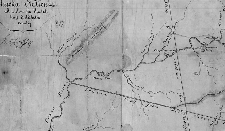
Estanaula, Tuesday, 26th June 1792

Present, the Little Turkey, great beloved man of the whole nation; the Badger, the beloved man of the Southern division; the Hanging Maw, beloved man of the Northern division; the Boot, the Black Fox, the Cabin, Path Killer, head-men of Turkey’s town.[1]

Chief Pathkiller

As we examine the Beloved Chiefs from Turkey’s Town. Chief Pathkiller’s information is the most confused. He is very important to the history of Turkey’s Town. He lived in Turkey’s Town for about 40 years. Today, there is a lot more information about this Chief. Yet, the internet is full of misunderstandings, misinformation, and confusion. 

I will try to sort this out. All of the genealogy websites have mixed, confused information about this Chief and his family. A lot of the information has been disproved, yet not removed or replaced with corrected information.  

Providing the most up-to-date information will take more than one post.  I will provide what can be proven. Where needed, I will state what is “believed” to be true from the leading researchers. This is not a genealogy site, but I will provide what has been proven about Chief Pathkiller’s family with sources. This site focuses on Turkey’s Town. Thus, I am not providing information about the Western Nation after the arrival of the family.  

We will explore who Chief Pathkiller is. His name. I will explain the errors in the information on the various websites. There is only one Chief Pathkiller, who was the Principal (Beloved) Chief of the Cherokee Nation (1811-1827). I will explain who Pathkiller Jr is. There are NO Pathkiller I and Pathkiller IIs. What are the most precise estimates of his birth, and when did he die? Where is he buried? We will revisit where he lived. What was his role in the Creek War and, Treaty of 1816? As the Chief of the nation, what is his role? His family can be proven. Who are they? He had a nephew who was murdered, named Charles. 

Chief Pathkiller, His Name

Pathkiller is not a surname. Pathkiller, as a surname, is a European influence on the history of the Cherokee people. 

Most of the genealogy records use a Cherokee name for Chief Pathkiller. This name, “Nunnadihi” translates to Path Killer. This was Major Ridge’s name when he was young. His name later evolved to “the Ridge” and eventually to “Major Ridge”. In Wilkins’ book about the Ridge Family, Major Ridge or Pathkiller is spelled “Nung-noh-hut-tar-hee.” This translates to “he who slays the enemy in the path.” In English, Path Killer. [2] This is further confused by misinformation transcribed into the website of Find-a-Grave. This is also on almost every genealogy website. Yet this is Major Ridge’s name. Chief Pathkiller does not have a historical record using a Cherokee name. It is listed as Path Killer or Pathkiller. In my opinion, assigning a name to Chief Pathkiller is disrespectful to the Cherokee People and the Chief.

Roane County, Tennessee, Pathkiller

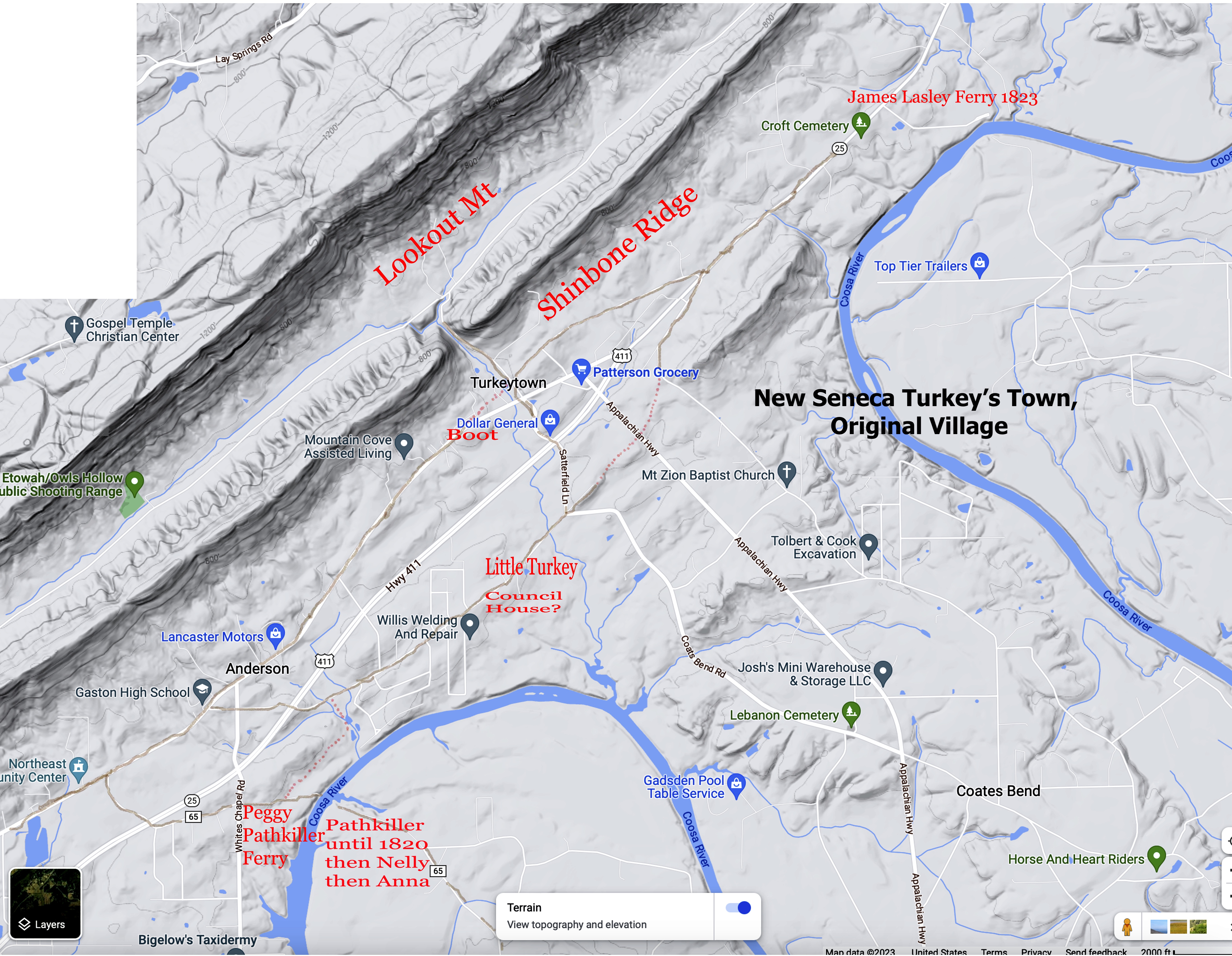
One of the confusing Pathkillers is the Pathkiller of Roane County, Tennessee. Many people have conflicted him with Chief Pathkiller of Turkey’s Town. This Pathkiller is stated to be the last hereditary Chief of the Nation and Colonel Pathkiller. This Pathkiller received a reservation of 640 acres, including a ferry on the Tennessee River. In a blog provided by “Tennessee State Library and Archives” it holds information on the court case involving this reserve. From the blog;

This Supreme Court case centered around a land dispute between Pathkiller and James Blair of Loudon County. In 1819, Pathkiller took advantage of a provision in the Calhoun Treaty and claimed a reservation of 640 acres that included the area known as Blair’s Ferry. Blair’s Ferry was on the Tennessee River in Loudon County.[3] Throughout this court case Pathkiller is referenced as: “. . .last hereditary chief of the Cherokee, and a Colonel under Andrew Jackson in the Creek War”. In this case, there is a daughter of Pathkiller named Sarah who married James T. Gardenhire. “Blair’s sons John and Wily continued battling for the property rights against Pathkiller’s daughter, Sarah, and her husband, James T. Gardenhire. After years of litigation, the Tennessee Supreme Court ultimately decided in favor of the Blairs, claiming that Pathkiller’s sale of the land to the Gardenhires had made his reservation claim null and void. The parties ultimately reached a compromise, and the Gardenhires agreed that they would “remove and give up all of said 640 acres with the ferry, and to remove any tenants that may be in possession of any part of the said tract…”[4]

No where in the reservation claim is this Pathkiller referred to as the Chief of the Cherokee Nation. He is not proven to be Colonel Pathkiller. This is also true in the granting of the reservation.(5) It is a statement made during the court case. But, not proven. It was recorded in the Tennessee State Supreme Court Case. This Pathkiller could be one of the other two Pathkillers listed in Col Gideon Morgan Jr’s regiment.

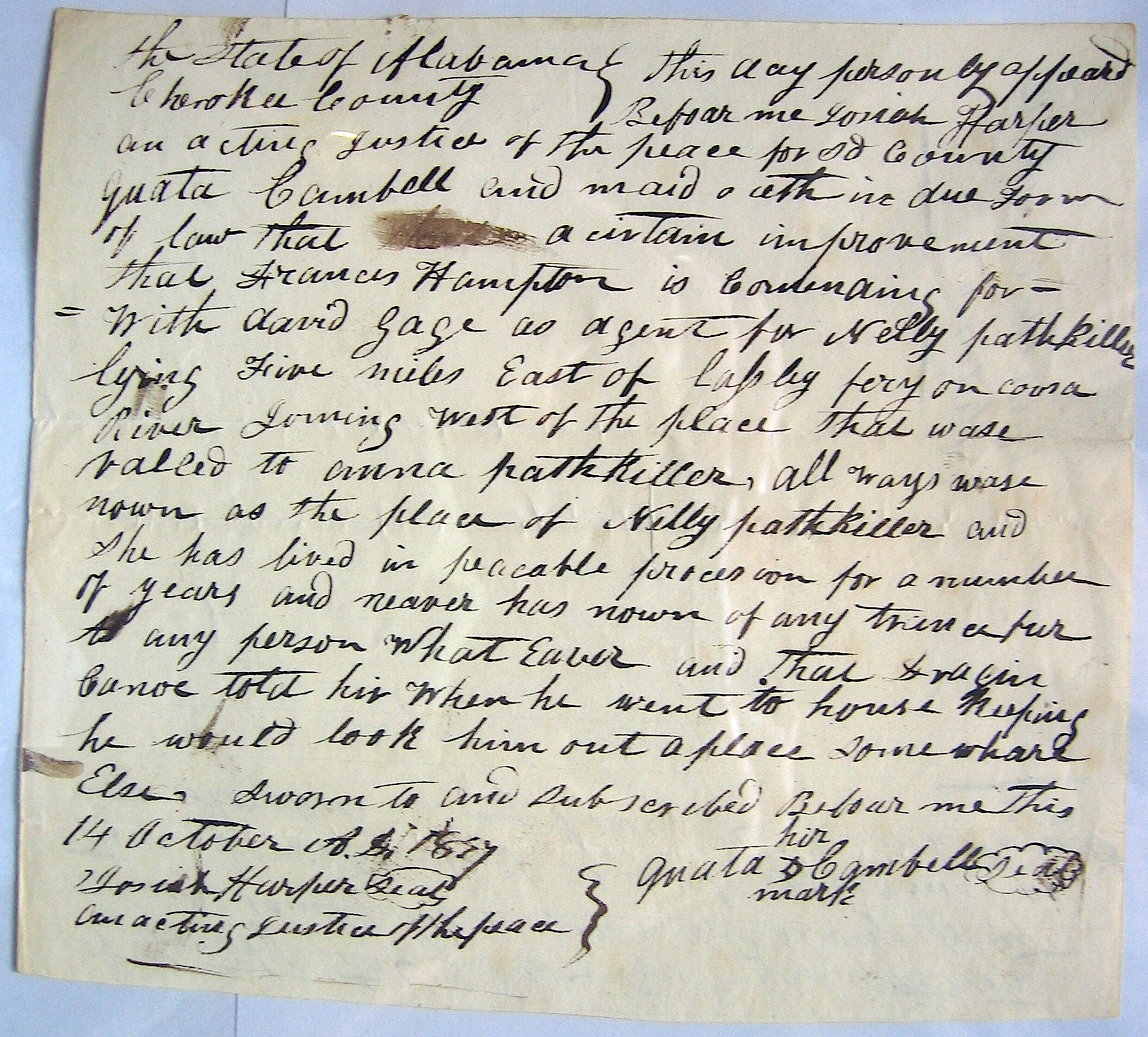
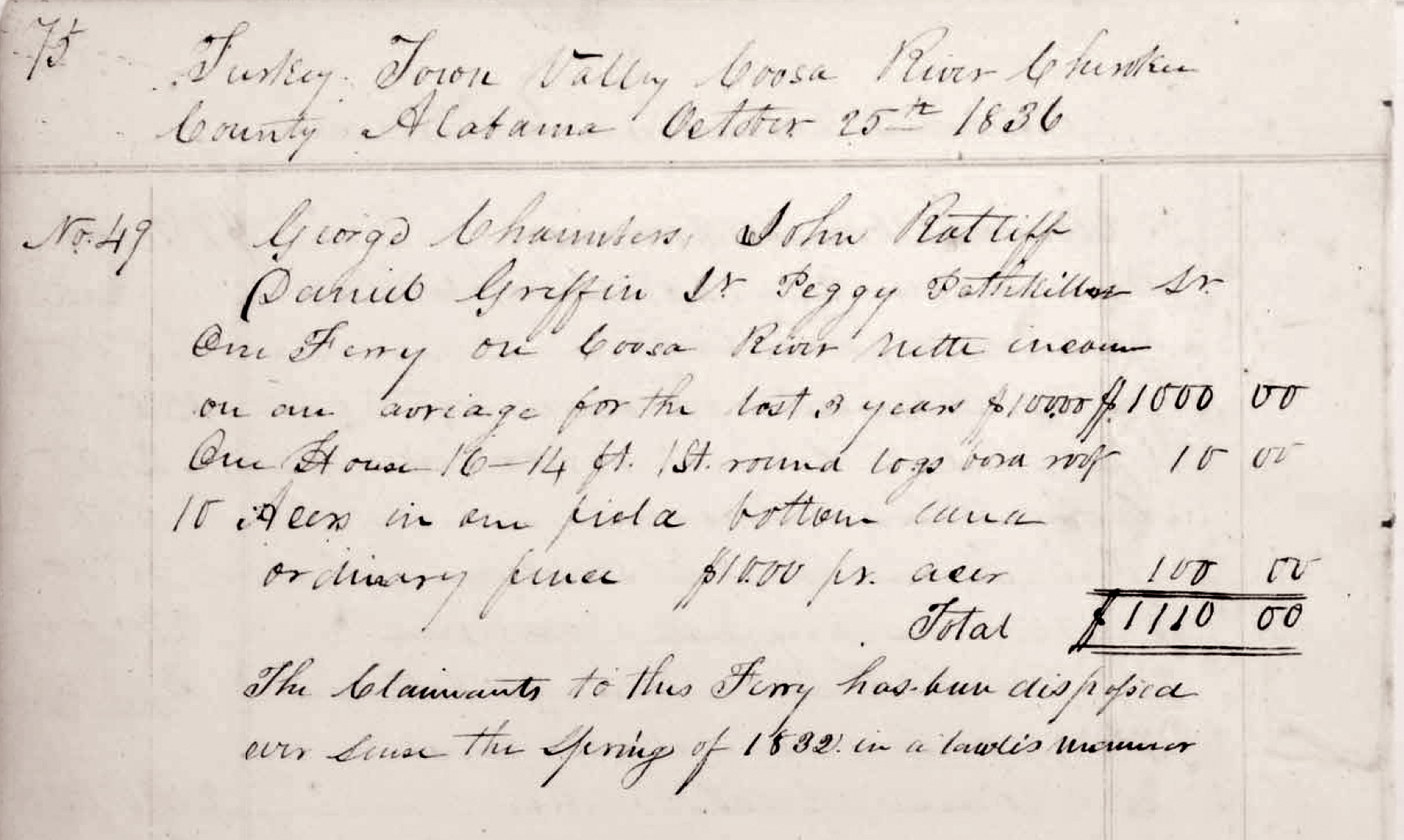
The account of this case appeared in the National Banner and Nashville Whig newspapers in full on 12 August 1830. Pathkiller in this case is not called Chief of the Nation. There is also no mention of him being related to Chief Pathkiller in Turkey’s Town.[6] There is no evidence to confirm this. The daughter named “Sarah, who married James T Gardenhire,” has no family connection to the Chief Pathkiller of Turkey’s Town. To add to this many genealogists list Susan “Sukey, Sooky” Martin as the wife of Chief Pathkiller in Turkey’s Town. This too is not proven. Others suggest she was married to his son, Pathkiller Jr or Pathkiller II.[7] [8] There is no Pathkiller II. It gets more confusing with the memorial marker (photo attached). Stating that this Pathkiller died in 1843.[9] This Pathkiller may be the Corporal or Sergeant with Col Gideon Morgan Jr’s Cherokee Regiment in the Creek War.[10]

A small memorial marker commemorating Path Killer sits on the western bank of the Tennessee River. The marker is located behind the Loudon Senior Citizens Center, 901 Main St., Loudon, Tenn. / Ross Rogers

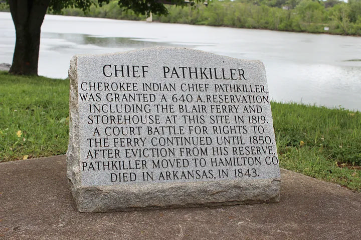
Chief Pathkiller, Chief of the Nation 1811-1827, died in January 1827, so he did not file a case in 1830.  His daughter and granddaughter stated he lives in Turkey’s Town. Source with proof later in another post. They never mention moving or living on the Tennessee River. He did not die in Arkansas. He does not have a daughter named Sarah that can be proven. We will discuss his proven family and where he lived.

This Roane County Pathkiller can not be the hereditary chief of the Cherokee, with a death date of 1843. That would mean there are two Principal Chiefs of the Nation. Chief John Ross was Principal Chief from 1828 to 1866.[11] This Pathkiller did exist. He did move to Arkansas. Yet, this Pathkiller of Roane County, Tennessee, is not the Principal Chief of the Cherokee People. He has not been proven to have any family relationship to Principal Chief Pathkiller of Turkey’s Town. Nor any of his family. The only connection is the similarity of the name Pathkiller. There are many people with the name Pathkiller. Not everyone who has that name is kin. 

Pathkiller Junr

https://catalog.archives.gov/id/100595161 Image of the Treaty, January 6, 1817, NARA

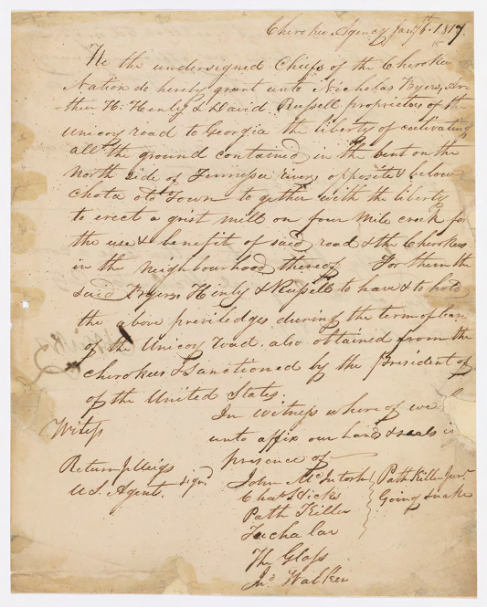
Who is Pathkiller Jr (Pathkiller Junr)? It may be the Roane County, Tennessee, Pathkiller. Attached is a copy of the only document with Pathkliller Junr. An 1817 treaty dealing with the approval of the use of roads it has two Pathkillers. Pathkiller and Pathkiller Jr.[12] This leads to the question of whether the second Pathkiller is Pathkiller’s son. The Cherokee people did not have a culture of naming a son after the father. They did not use the suffix Jr. This is the interpreter’s choice in using “Junr.” Jr. to show two different Pathkillers, one being younger than the other. They are not displaying a family notation. In this treaty, the interpreters are Return J. Meigs, and Chief Charles R. Hicks. Meigs is the Agent and Chief Hicks is an interpreter, Chief Pathkiller’s second. Hicks is half Cherokee and half European. [13]

Conclusion

This Pathkiller of Roane County, Tennessee, is not the Principal Chief of the Cherokee People. He has not been proven to have any family relationship to Principal Chief Pathkiller of Turkey’s Town. Nor any of his family. Pathkiller Junr is a younger man with the same name. There is no son of Chief Pathkiller of Turkey’s Town named Pathkiller Jr.

We will continue the exploration of Chief Pathkiller and the misunderstandings in the next post. The Beloved Chiefs of Turkey’s town.


[1] Indian Affairs, Volume 1, ASP IA Vol. 1, searchable online the Library of Congress American State Papers web site pages 271-273, 26 June – 1 July 1792.

[2] “Cherokee Tragedy”, The Ridge Family and the Decimation of a People, Thurman Wilkins, second edition, revised, University of Oklahoma, Norman and London, 1986, page 7.

[3] https://tslablog.blogspot.com

[4] Ibid

[5] Survey of Pathkiller’s land on the south side of the Tennessee River at his ferry; https://teva.contentdm.oclc.org/digital/collection/p15138coll23/id/857

[6] National Banner and Nashville Whig, (Nashville Tennessee) 12 August 1830, Newspaper.com, Second paragraph; Pathkiller, the defendant in the court and Plaintiff below, claim a reservation under the treaty of 1817 and 1819, of 640 areas of land with a life estate there in to himself and a reversion in fee simple to his children, out of the lands surrendered by these treaties to the United States. He was the head of an Indian family; and on register of life interest reservations, in the office of thee United States Agent for the Cherokees, is in the following entry: “1818, June the 14th, Pathkiller a native, 5 in family, on the main Tennessee river, about 2 ½ miles above the mouth of Sweet-water creek. There is a ferry on the place: Given under my hand and private seal, there being no seal office, the 2d Sept. 1826. H. Montgomery, United States Agent for the Cherokee. . . Pathkiller moved to this reservation, the land in dispute, in April or May 1819, having occupied of by his tenet Caves, from 1817.

[7] Chattanooga Daily Times (Chattanooga, Tennessee) · Sun, May 27, 1934 · Page 41, Newspaper.com

[8] WikiTree, Susan Martin; https://www.wikitree.com/wiki/Martin-4178

[9] Chasing Path Killer, Ross Rogers, blog, 30 April 2019; https://medium.com/@TheRossRogers/chasing-path-killer-38a53d015538

[10] US, Index to Compiled Service Records of Volunteer Soldiers Who Served During the War of 1812, 1812-1815; fold3.com

[11] https://collections.gilcrease.org/anthology-articles-john-ross-papers-collection

[12]  CHEROKEE AGENCY, January 6, 1817. CHEROKEE AGENCY, January 6, 1817. The use of the Unicoy road, so called, was for twenty years. Treaties with the Cherokees, 1819, Oklahoma State University, Digital Resources and Discovery Services, Tribal Treaties Database; https://treaties.okstate.edu/treaties/treaty-with-the-cherokee-1819-0177?query=%20path%20killer  

[13] https://catalog.archives.gov/id/100595161 Image of the Treaty. January 6, 1817, NARA

Trust in the Lord with all your heart, and do not rely on your own understanding;
 in all your ways know him, and he will make your paths straight. Proverbs 3; 5-6 CSV

Uncovering the History of Turkeytown, Location, By Chief Pathkiller’s family

24 Monday Feb 2025

Posted by Jeffrey Sauls in Local History

≈ Leave a comment

Tags

cherokee-indians, native-american, New Seneca, northeast-alabama-history, trail-of-tears, turkeytown

We have discovered that the actual location of Turkey’s Town is in Etowah County, Alabama. It is not one mile south of Centre, Alabama. This was revealed in the last post. Chief Charles R. Hicks and Reverend Daniel Butrick have given that information. How did the location in Centre, Alabama, come to be, and why is there conflicting information? Where did Chief Pathkiller live and where was his fort?

In this post, Chief Pathkiller and and his family explain where they lived. In the next post, we will examine the Centre, Alabama location. Hopefully, you will see the confusion come to an understanding.

The past Historians must not have had access to the family’s disputes. These disputes were between Pathkiller’s family over ownership of improvements. We learn a lot about Pathkiller’s family and uncover the history of Turkeytown.

The treaty of 1830 established the “Indian Removal Act.” The 1835 treaty resulted in the Trail of Tears, the forced removal of the Cherokee people. The Cherokee people filed claims for payment with the United States for what they left behind. They are referred to as Validation/Spoliation Claims. The people would be paid for houses, furniture, crops, and other miscellaneous items. This leads to misunderstandings within families. Chief Pathkiller’s grandchildren got into one of these disputes. Fortunately, this provides us with information on the location of Turkey’s Town. Bonus info is Pathkiller’s family history.

Pathkiller’s Grandchildren Dispute 1837

12 of September 1837 Personally, comes before me James Lasley being duly sworn that he does live in the neighborhood of the contested improvements. . . The grandfather of this claimant Anna Pathkiller being the person who made the first improvement and kept it and held it legally as his according to the Law and usage til about the year 1815 he made his children stay there to mine his stock and use it as a stock keeping place   Tis true Dragging Canoe one of the old mans children did stay on the place for the purpose of keeping the stock as above and for no other purpose and under the direction and consent of the old man this grandfather as above nor did the old man give it or convey it to any one but his wife Peggy   he died and left this in possession of the said place . . .this Peggy was the Legally possessed of it     Before Peggy died a short time she made a will and left it Nelly her daughter who is the mother of Anna the present claimant and this Nelly told this despondent that she had given this said improvement to this same claimant Anna Pathkiller1

Above is a statement from an affidavit in part of James Lasley to Wilson Lumpkin. Lumpkin is the US Commissioner to the Cherokee Indians (1836-1837). He became Georgia’s Governor 1837-1841. He recorded several of the affidavits. The affidavit concerns the dispute of ownership of improvements on Chief Pathkiller and Peggy’s estate in 1837. This estate is today’s Alford’s Bend, Etowah County, Alabama.

Several affidavits were collected. They aimed to settle a dispute between Anna Pathkiller Hampton and Dragging Canoe’s son, daughter, and widow. The disagreement was over the improvements on the East side of the Coosa River at Peggy Pathkiller’s ferry.

Affidavit taken by Josiah Harper Justice of the Peace Cherokee County, Alabama 14 Oct 1837. Quata Campbell is Chief Pathkiller and Peggy’s daughter married to George Campbell.2

Dragging Canoe (not the Chickamauga war Chief) is the son of Pathkiller and Peggy. Sky-ah-too-ka is Dragging Canoe’s son. Dragging Canoe’s wife is Watty, and his daughter is Martha. David Gage, their representative, argues for them about ownership of the improvements. These improvements are on the “East side of the Coosa River five miles below Lasley’s ferry.”  Lasley’s ferry is the today’s Croft ferry, Etowah County, Alabama. (James Lasley is a post of its own later.)

Anna Pathkiller is married to Frances Hampton. Anna is Nelly Pathkiller’s daughter. Nelly is the daughter of Peggy and Chief Pathkiller. Nelly is listed in Peggy’s will.  Quata is Chief Pathkiller and Peggy’s daughter, married to George Campbell. She is the sister to Dragging Canoe and Nelly. She is listed in Peggy’s will. Dragging Canoe is not listed in Peggy’s will, she only takes care of the female side of the family. This was Cherokee custom.

There are several other affidavits about this dispute. Money Hunter has similar statements. Richard Ratliff has very similar statements. He is the husband of Charwahyooca (also known as Peggy Pathkiller Jr.). She is daughter of Pathkiller and Peggy and listed in Peggy’s will. Michael Wren collected the affidavits from Miscellaneous Claims Papers, 1836-1839. They are listed to the First Board of Cherokee Commissioners, Entry 236. They originate from the Records of the Bureau of Indian Affairs. This is Record Group 75, at the National Archives Building in Washington DC.

This is a lot of information just to say; “The grandfather of this claimant Anna Pathkiller being the person who made the first improvement and kept it and held it legally as his according to the Law and usage til about the year 1815.“ This does confirm that Pathkiller’s residence was 5 miles below Lasley’s on the east side of the Coosa. Also, the location of the pickled fort and ferry.

Note on Pathkiller’s Fort. Return J. Meigs to Nathan Lawson Pay Master General, 22 Jan 1820. “Also a number of members of the Cherokee warriors who were stationed at Turkey Town for one month only, in the time of the Creek War 1813-1814. This post camp had no officer to command them they were in a pickeled fort surrounding the resident of the King or Head Chief Pathkiller.“3 This was a request to pay the seventeen warriors for their service.

A modern Google map of Turkeytown, Etowah County, Alabama, shows the original village site of New Seneca, Turkey’s town. Chief Pathkiller on the south end. James Lasley on the north end. The distance between the two is about 5 miles. Google Maps website. Notation in red added by this Researcher.

In the prior post on this subject, Chief Charles Hicks stated that friendly Creeks stayed at Pathkiller’s Fort. The fort was located in Turkey Town. The fort is 20 miles below Coosahatachee. Review the post on the Creek War Claims. Coosahatachee is on Terrapin Creek 10 miles below Fort Armstrong.

This is confirmation that the original village of Turkey’s Town would start at today’s Fitts Ferry (Pathkiller’s first ferry). This is in Etowah County, Alabama.

The Confirmation of Turkey’s Town by white intruders. The takeover of Peggy Pathkiller’s ferry

White US citizens move into Turkey’s Town. Their actions will confirm the location of Turkey’s Town. They will also confirm Pathkiller’s first residence and ferry.

A Report to the Alabama Chapter of The Trail of Tears, 2007. Chapter 8 Topography of the Removal Routes, Ferry Crossings on Major Rivers and Tributaries by Michael Wren;

COOSA RIVER #8 Township 11 South, Range 7 East, Section 20 

Mrs. Pathkiller’s Ferry / Kay’s Ferry / Fitts Ferry 

The road from Asheville to Jacksonville crossed the Coosa River in Section 20. George        Chambers, John Ratliff, Daniel Griffin Jr., and Peggy Pathkiller Sr were joint owners of a Ferry on the Coosa River in Turkey Town Valley, Cherokee County. The Valuations gave an average annual income of $100.00. Included with this Valuation was a 16’ x 14’ house and 10-acre field of bottom land under fence. The Claimants were dispossessed since spring of 1832. 

John Ratliff filed a Claim for his ferry on January 16, 1837 before Josiah Harper, Acting Justice of the Peace for Cherokee County Alabama. He stated that the Ferry was 1 ½ mile miles below Turkeytown and was then in the possession of James Kay. He stated, however, that the ferry was taken from him by a white man by the name of Hays shortly after the laws of Alabama were extended over the Cherokee lands in January 1832. The Original Patentee for the ferry’s location was James Kay.4

In the St Clair County court records, James Kay filed for a license to operate a ferry. This was on the Coosa River in the August 1833 term. Mr. Kay stated he acquired the ferry from Hannibald Hays, which was in Turkey Town. 

The Applicant, Kay by attorney moved the judge and commissioners of Roads & revenue that they would grant him license and take a bond for the ferry which the legislature authorized Hanibald Hays (under which this applicant claim by purchase) to establish on the Coosa river where the road crosses the same at the place known by the name of Turkey Town in St Clair County which motion was __-ted and the court refused to grant license or take a bond from the applicant on the grounds they had previously granted to David Gage for the same ferry sometime prior to the act of the legislature giving it to Gage. James Kay by David Gage, St. Clair County, Alabama Court Minutes (1828-1834), Commissioners Court August Term 1833, pages 226-227

Page 172 of the same Court minutes; Order by the Court that David Gage be authorized to keep a ferry on Coosa River at Peggy Pathkillers provided it does not interfear with the Charter limits of John H Garrett as granted to him by the Legislature, at the following rates. . . 5

The above information shows that a white man named Hannibal Hayes took over Peggy Pathkiller’s ferry and property. He would sell it to James Kay and Mr. Kay would patent buy it in 1840s from the US government. Mr. Kay stated he was on the property with a pre-exemption date of 1838. 6 He worked with David Gage to acquire the license to operate the ferry at that location. Notice in the copy of the claim above it states, “in a lawless manner”.

David Gage is married to a Cherokee woman. Her name is Lucy Fish. He has acquired a house and property from the Dragging Canoe’s estate (Chief Pathkiller and Peggy’s son). The family filed a claim in Benton County.

David and Lucy Gage also held property in Will’s Valley. Will’s Valley is where they lived.

The above 1835 document has lots of information. Both Benton (Calhoun) and Saint Clair Counties claimed the area. The area was still in the Cherokee Nation. The document explains Dragging Canoe’s family. Dragging Canoe died about 1827 his estate records are in the Saint Clair County, Alabama estate records. The above document stated the residence for Nelly is next door. Dragging Canoe and his family do not have rights to the improvements. They could not sell the property. Gage and Dragging Canoe’s family lost in claiming the improvements. Chief Pathkiller and Peggy separated about 1816-1817. These improvements would belong to Peggy. Chief Pathkiller “took” a new wife and moved north. Review James Lasley’s statements at the top. Cherokee custom is Peggy would care for and leave her estate to the female children and their families. All of the contested improvements are in today’s Alford’s Bend. (Alford’s Bend will be discussed in its own post.)

If you are reading closely, you see the whites are taking what belongs to the Cherokee people. Read between the lines. James Brown and Tarply Nall both are white and have no connection to the Cherokee. They have moved into the area. Nall will try to buy the land from Sky-ah-too-ka. He stated in an affidavit that he spoke with some of the elder Cherokee and did not purchase the land. He said that Sky-ah-too-ka never owned the improvement. The Cherokee people have not gone to the West. This predates the forced removal of the 1835 treaty. The date is 1832, and Peggy Pathkiller is still living. Peggy died in 1833. Chief Pathkiller died in January 1827. He had moved north and started a new improvement on the Coosa River. He had taken a new wife.

Conclusion

We gather a lot of information on the location of the original village from the above information. The dispute with Pathkiller’s family places the Chief on the east side of the Coosa River. He lives there until he and his wife, Peggy, separate. This is today’s Alford’s Bend. One of the notations above stated the ferry was one-and-half miles below Turkeytown. Turkeytown Creek is one-and-half miles north of Fitts Ferry on the West side of Coosa River.

To recap the last post with this one. Chief Little Turkey lives at Turkeytown Creek on the East Road, (Coats’ Bend Rd.) The Boot lived at Turkeytown Creek on the West Road (Old US 411.) Chief Pathkiller lives on the East side of the Coosa River at his ferry (Fitts Ferry.)

In the next post, I will explain the move north and the new improvements for Chief Pathkiller. “One mile south of present day Centre.” His new wife and an illegal sale of part of his estate. Additionally, I will explain the dispute between the Garrett Family and John Ridge, who acquired most of Chief Pathkiller’s estate. Uncovering the History of Turkeytown, Pathkiller’s Ferry.

  1. Affidavit of James Lasley #574, 12 September 1837, Folder of James Lasley. Miscellaneous Claims Papers, 1836-1839, of the First Board of Cherokee Commissioners, Entry 236; Records of the Bureau of Indian Affairs, Record Group 75; National Archives Building, Washington DC. ↩︎
  2. Affidavit of Quata Campbell Miscellaneous Claims Papers, 1836-1839, of the First Board of Cherokee Commissioners, Entry 236; Records of the Bureau of Indian Affairs, Record Group 75; National Archives Building, Washington DC ↩︎
  3. Correspondence and miscellaneous records 1819-1920 (NARA Series M208, Roll 8), Records of the Cherokee Indian Agency in Tennessee, 1801-1835, Family Search.com, image 420, https://www.familysearch.org/ark:/61903/3:1:3Q9M-CSHM-PQM1?i=419&cat=285733 ↩︎
  4. Report to the Alabama Chapter of the Trail of Tears titled Alabama Collection Camps, Forts, Emigrating Depots and Travel Routes Used During the Cherokee Removal of 1838-1839, Chapter 8 on Topography of the Removal Routes, Ferry Crossings on Major Rivers and Tributaries. Page 248, https://nationaltota.com/alabama-forts-and-camps. ↩︎
  5. John Ratliff’s Spoliation Claim for a Ferry and Improvement. Folder of John Ratliff; Miscellaneous Claims Papers, 1836-1839, of the First Board of Cherokee Commissioners, Entry 236; Records of the Bureau of Indian Affairs, Record Group 75; National Archives Building, Washington DC. In the St. Clair (AL) County Court Minutes (1828-1834) there is a road order on pages 172-173 “Ordered by the Court that David Gage be authorized to keep a ferry on Coosa River at Peggy Path killers provided it does not inter fear with the Charted limits of John H Garrett as Granted to him by the Legislature, at the following rates…” and on pages 226-227 “The applicant James Kay by David Gage attorney moved the judge and Commissioners of Roads & revenues that they would grant him license and take a bond for the ferry which the legislature authorized Hannebald Hays (under whom this applicant claims by purchase) to establish on the Coosa river where the road crosses the same at the place known by the name of Turkey Town in St Clair county which motion was-ted and the court refused to grant license or take a bond from the applicant on the ground that they had previously granted license to David Gage for the same ferry sometime prior to the act of the legislature giving it to Hays. ” See also Acts of Alabama for 1832-1833, Extra Acts, page 150, which Act authorized Hannibal Hays on the Coosa River. 
      ↩︎
  6. Bureau of Land Management, General Land Office Records, Eastern States Office, Springfield, VA. Pre-emption Certificate #6,885 for James Kay of Cherokee County Alabama issued June 1, 1845 for fraction “A” of fractional Section 20 in Township 11 of Range 7 East. Pre-emption Certificate #8,419 for James Kay of Cherokee County Alabama was issued April 10, 1847 for the northwest quarter of the southwest quarter of Section 20 in Township 11 of Range 7 East. Both in the District of Lands subject to Sale at Lebanon Alabama. http://www.glorecords.blm.gov/PatentSearch/. ↩︎

Trust in the Lord with all your heart, and do not rely on your own understanding;
 in all your ways know him, and he will make your paths straight. Proverbs 3; 5-6 CSV

Uncovering the History of Turkeytown, Traditional Location

21 Tuesday Jan 2025

Posted by Jeffrey Sauls in Local History

≈ 2 Comments

Tags

alabama-history, cherokee, cherokee-county, cherokee-indians, etowah-county, history, indigenous, native-american, native-americans, New Seneca, northeast-alabama, northeast-alabama-history, trail-of-tears, turkey-town, turkeytown

“The Southern Indians . . .the records of their history are records by whites and are marred by prejudices and misunderstandings . . .”  R. S. Cotterill, The Southern Indian, Preface. 

Traditional histories

Traditional histories of white people create confusion about the location. Let’s look at the statements about 3 different places for Turkey’s Town. I will explain the timeline for establishment in its own post later.

Location one.

One mile south of the town of Centre on the west side of the Coosa.

August 7, 1936; Cardon’s History Cherokee. Front page, Coosa River News, first column five paragraphs down;

“Turkey Town was established some time prior to 1770, and was one of the most important of Cherokee establishments. It is here that Col. Campbell, the noted British soldier and superintendent, lived at times during and after the Revolutionary War. Turkey Town was located about one mile from Centre on the west side of the Coosa River, not far from the mouth of Terrapin Creek. This fact is attested to by all of the authorities on the subject, and is shown on a half a dozen maps owned by the writer, dating from 1817 to 1835. The old Indian Trail or ‘Creek Path’ running from Creek Path Town, now Guntersville, crossed the river at Turkey Town, where after the turn of the 19th Century, Pathkiller, King of the Cherokee, operated a ferry.”1

Mr. Cardon does not give a citation except for “all of the authorities.” He would also cite C. C. Royce’s 1884 Map. The information on the location did it come from James Mooney and Royce’s map? Did it come from the Alabama Historical Society?

James Mooney’s book Myths of The Cherokee and Sacred Formulas of the Cherokees states;

Gun’-di’-gaduhun’yi (abbreviated Gun’digadu’hun)- “Turkey’s settlement” (gu’nu’, turkey), so called from the chief, Turkey or the Little Turkey, upon the west bank of Coosa river, opposite the present Center, in Cherokee county, Alabama.2

Charles C. Royce served with the Bureau of Indian Affairs and Ethnology. He was an author and businessman. He confused people with his placement of Turkey’s Town on his “Land Cession Map” by calling it a “Creek” Village.3 https://www.geographicus.com/P/ctgy&Category_Code=roycecharlesc

This created confusion in a report to the Governor of the state of Alabama. The Governor of Alabama requested a report from the Historical Commission. It was printed on December 1, 1900, and copyrighted in 1921. The report provides two Turkey Towns, both at the same location.4

Page 418; Creek Indian Town and Villages, Chapter IV;

Turkey Town, an Upper Creek Village, is marked on Royce’s map (1884) on the western shore Coosa River opposite the influx of Terrapin Creek, from the Southeast and also opposite the recent town of Centre.

Page 420; Chapter V Cherokee Towns and Villages in Alabama;

Turkey Town. Founded about 1770, and situated in the bend of the Coosa river opposite the town of Centre in Cherokee County. It was a place of great importance in the Nation and was named for one of its most noted Chiefs “The Turkey”, here under this chief’s lead originated many of hostile expeditions against the white settlers of Tennessee and Kentucky. -see Pickets History of Alabama Vol. 1 page 163.

These notations in this 1900 report are the sources for Mr. Cardon and historians later.

A reference noted above; see Pickets History of Alabama Vol. 1, page 163. This reference does not give any information on the location of Turkey’s town.

Albert Pickett’s “History of Alabama and incidentally of Georgia and Mississippi, from the earliest period”. On page 163 Mr. Pickett writes;

Will’s Town and Turkey Town—important Cherokee establish. The former was named for a half breed called Red-headed Will. At these towns lived the British Superintendent, (the celebrated Col. Campbell,) before and during the Revolutionary War. . . 

Cherokee County History written by Mrs. Margaret Stewart repeats these notes. 1956 Cherokee County History Volume 1, page 204;

“Turkey Town named for noted Chief “The Turkey” and located in the bend of the Coosa River opposite to and one mile south of the town of Centre. It was founded about 1770, and was considerable size and importance. It is marked on the Royce’s Map (1884) opposite the influx of Terrapin Creek. Chief Turkey lived on the east side of Turkey Creek on what later became the Sims farm. By some Indian agents and traders, the town was called New Seneca.”

page 214;

“Turkey Town was established some time prior to 1770 and was one of the most important Cherokee establishments. Col. Campbell the noted British soldier and superintendent lived here at times during the Revolution. Turkey Town was located one mile from Centre on the west side of the Coosa not far from the mouth of Terrapin Creek. The old Indian Trail or Creek Path crossed the river at Turkey Town, and Pathkiller had a ferry here.”5

Location two.

Turkey’s Town from Gadsden to Centre, Alabama.

Another location for the town is described in a History of Etowah County, Alabama. During the centennial of Etowah County Alabama in 1968 a committee was formed to write a history of the county. “History of Etowah County Alabama; Part I, A History of Etowah County, Alabama by Elbert L. Watson.”6

page 9, Chapter I, Etowah County; An Ancient Homeland;

Chief Little Turkey and his followers located their village, Turkey’s Town, along the northern bank of the Coosa River in an extremely fertile and productive area of the Coosa Valley. Actually, Turkey’s Town, or Turkeytown, as it was later called, was more an area instead of a village, since it extended from just south of Centre to below Gadsden where the Coosa River and Big Wills Creek formed the Cherokee boundary line.

The third location.

99.1 percent underwater of Weiss Lake in the area of LIttle River, Chattooga River, Coosa River.

A third location was noted in 1993. The Turkeytown Association of Cherokee held an Intertribal “Pow Wow” next door to Gaston High School, Etowah County, Alabama. Cherokee County Herald September 15, 1993, the front-page headline is; “Cherokee Indians celebrate at the wrong place? Alabama historian and researcher Don Naylor says YES”; written by the editor Paul W. Dale. He states;

“Turkeytown is actually located some miles from where the festival organizers have laid claim to a site they contend is where a Pow wow was held some 150 years ago. The truth is the truth and you cannot bend it.” Naylor is listed as a historian that researcher who primarily hunts Creek Indian history and artifacts throughout the Cherokee County area. “Turkeytown is now 99.1 percent under water of Weiss Lake.” Bob Minnix of the Cherokee County Historical Museum in Centre. “Turkeytown is actually located in the area of Little River, Chattooga, Coosa.”7

(As of note, I was a board member of the Turkeytown Association of the Cherokee. This was an educational group to promote Cherokee and Turkeytown history.)

If you look at Wikipedia, you will get all three locations.
Much of the original site of Turkeytown is now underwater, due to the impoundment of the Coosa River which formed Weiss Lake. The present-day community of Turkey Town in Etowah County, Alabama is fewer than ten miles southwest of Centre, Alabama and near the original site of the town.

https://en.wikipedia.org/wiki/Turkeytown_(Cherokee_town)

Oliver Day Street “The Indians of Marshall County Alabama”;

About 1777, Wills’ Town was established by the Cherokee. . .about the same time Turkey Town was built by them on the Coosa river opposite the present site of Centre, Cherokee County, Alabama. 

(reference is “Pickett’s History of Alabama”, vol I, page 163; Royce in the 5th Annual Report Bureau of Ethnology, Map 8) 8

Mr. Street’s statements are like those of many other local histories and state historians who repeat the same information.

Conclusion

So, where is the original site for Turkey’s Town? With the above, there is no conclusion. With the above, there is confusion. Three locations? Spread from today’s Gadsden to Centre, Alabama?

The correct location is where? Where is this noted “Sim’s farm, east of the creek”? Where Chief Turkey lived. Are all the places part of Turkey’s Town?

What do the Cherokee people say? What do the people who interacted with Cherokee people in Dah-noo-wey-ye say about the location?

Next time, we will start looking at those sources. Till then, study Gen. John Coffee’s map.9 Compare it to Royce’s map above.

  1. “Coosa River News”: Friday 7 August 1936: Page 2: Gadsden Public Library, Genealogical and History Library: Microfilm. ↩︎
  2. Myths of The Cherokee and Sacred Formulas of the Cherokees by James Mooney from the 19th and 7th Annual Reports B. A. E. published in 1900 and reproduced 1982, page 521, “Glossary of Cherokee Words. ↩︎
  3. Map of the former territorial limits of the Cherokee “Nation of Indians;” Map showing the territory originally assigned Cherokee “Nation of Indians.” Published 1884, author C.C. Royce. Library of Congress. ↩︎
  4. Publication of the Alabama Historical Society Miscellaneous Collection: “Report of the Alabama Historical Commission to the Governor of the State of Alabama December 1, 1900”: Edited by Thomas McAdory Owens, Chairman: Montgomery Alabama: 1901: Google Books eBook: Public Domain. ↩︎
  5. “Cherokee County History 1836-1956 Volume 1”: Mrs. Frank Ross Stewart: Centre, Alabama:1956. Gadsden Public Library. ↩︎
  6. “A History of Etowah County, Alabama”: 1968: Etowah County Centennial Committee: Woodrow J. Stephens, Joe Barnes, Jerry B. Jones, Juanita Miller, and Elbert L. Watson; Gadsden, Alabama: Roberts and Son: Birmingham, Alabama. Copy in possession of the writer. ↩︎
  7. “Cherokee County Herald September 15, 1993”: Editor Paul W. Dale: Front page: Copy in possession of the writer. ↩︎
  8.  “The Alabama Historical Society, Montgomery, Alabama, Reprint No. 8”: XII The Indians of Marshall County, Alabama, Montgomery, Alabama, 1904, page 206: Oliver Day Street, Guntersville, Alabama: Google Books eBook: page 185. ↩︎
  9. A piece of the map, Sketch of the Disputed Country Between the State of Georgia and the
    Cherokee Nation. Record Group 75, Records of the Bureau of Indian Affairs, 1793-1999, Series,
    Central Map Files, 1824-1962, National Archives Catalog, General John Coffee. ↩︎

Trust in the Lord with all your heart, and do not rely on your own understanding;
 in all your ways know him, and he will make your paths straight. Proverbs 3: 5-6 CSV

Subscribe

  • Entries (RSS)
  • Comments (RSS)

Archives

  • February 2026
  • January 2026
  • December 2025
  • November 2025
  • October 2025
  • September 2025
  • August 2025
  • July 2025
  • June 2025
  • May 2025
  • April 2025
  • March 2025
  • February 2025
  • January 2025
  • December 2024

Categories

  • Local History

Meta

  • Create account
  • Log in

Website Built with WordPress.com.

  • Subscribe Subscribed
    • New Seneca Turkey's Town
    • Already have a WordPress.com account? Log in now.
    • New Seneca Turkey's Town
    • Subscribe Subscribed
    • Sign up
    • Log in
    • Report this content
    • View site in Reader
    • Manage subscriptions
    • Collapse this bar
 

Loading Comments...