Tags
alabama-history, cherokee-indians, Chief Pathkiller, native-americans, northeast-alabama-history, Pathkiller, trail-of-tears, turkeytown
Chief Pathkiller, Proven, Not Proven
We continue to discuss the proven and not proven for Chief Pathkiller. We must discuss Robert Moore and Nancy Ann “Polly” Pathkiller’s story.
Some confusing information comes from a blog, THE LEGEND OF PATHKILLER, by Lee Standing Bear Moore and Takatoka;
During a war between the white man and American Indians between 1790 and 1803, in what would become the state of Kentucky, a band of Overhill Cherokee warriors of the Red Paint clan captured a group of white soldiers and brought them to their Chief Pathkiller.
One of the captives was a young soldier by the name of Moore. (His name may not have been Robert Alec Moore.) Chief Pathkillers’ pretty young daughter, who was attracted to the handsome Moore, put together a plan to free Moore. Pathkiller’s daughter gave up her Indian identity and married Moore. Nancy Ann “Polly” Pathkiller-Moore and Robert A./Alec Moore had eight children 1
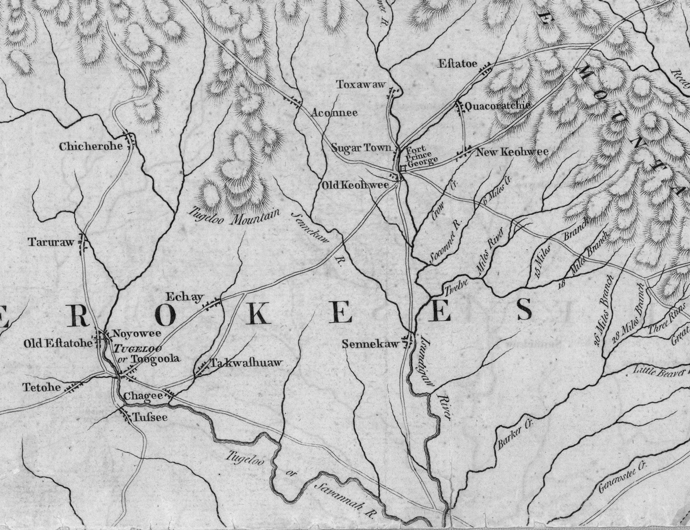
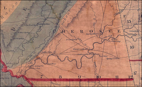
There are several issues with the story. Chief Pathkiller, Principal Chief of the nation, can not be proven as living in Kentucky. His daughter, Nancy, with Peggy, can only be proven to have lived in Turkey’s Town with her son, Crying Snake.
No source citations are provided with the Moore family story. However, the majority of the Genealogy websites use this information. Nancy, the daughter of Chief Pathkiller and his wife Peggy, did NOT marry Robert Moore. Notations of this Moore family in ancestry.com list Nancy Ann “Polly” Pathkiller dying in 1833, other sites state 1832.
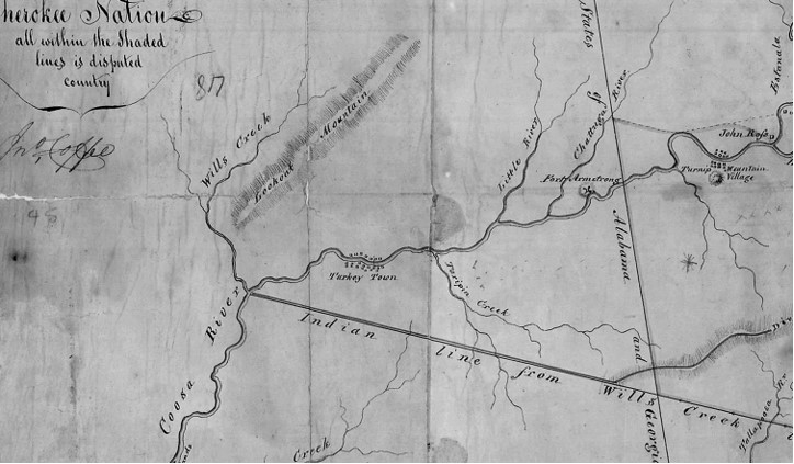
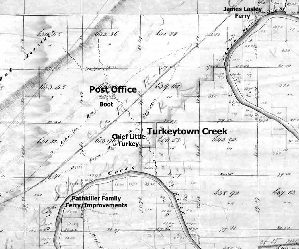
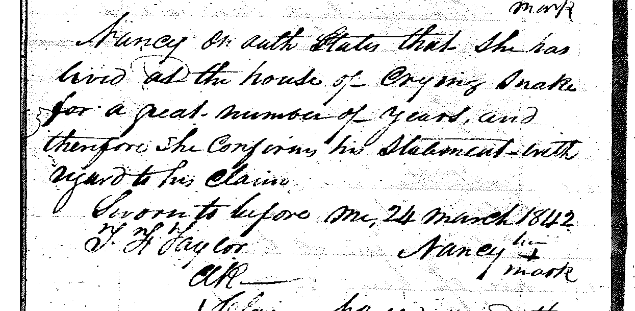
Nancy, daughter of Chief Pathkiller, and wife Peggy, is still living at the time of the stated death. She is a witness for her son Crying Snake, on a claim in 1842. Until the Trail of Tears in 1838 she is living in Turkey’s Town. She states, “she lived at the house of Crying Snake for a great number of years.” Nancy Pathkiller, Crying Snake, and Houston (Eyoostee) are listed in the Captain John Benge Detachment. They leave Fort Payne in September 1838. They arrive in the West in January 1839 on the “Trail of Tears”. 2
Listed in Peggy “Pathkiller’s” will;, Saint Clair County, Alabama, to my oldest daughter Nancy. Nancy’s sons are listed; To my grandson Crying Snake. To my grandson Eyoostee. 4
Other Documentation shows that Nancy is living passed the date of 1832. Register of Payments, Book A. Page 14; Crying Snake and Nancy are paid for their portions of Peggy’s ferry;
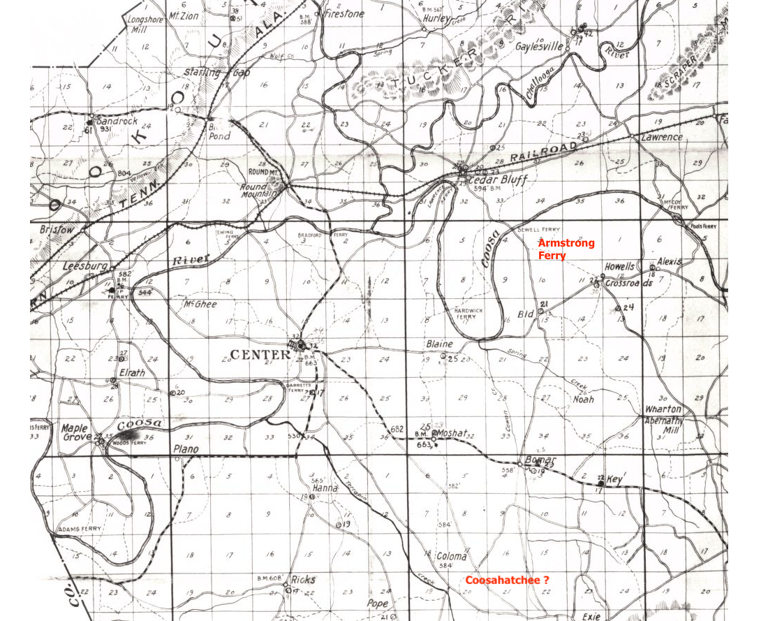
#12, Crying Snake, Alabama, Ferry on the Coosa, share of C. Snake $796. 87 ½ Sent West Jany 1839; #13, Nancy. Crying Snake’s mother. Ferry on Coosa, Share for Nancy $796. 87 ½ Sent West Jany 1839. St Clair County; Special Orphans Court, October 1833, page 241; October 31st 1833. . . This property claim was for the ferry where Chief Pathkiller died. (Centre, Alabama) 5 6 settlement had on the Estate of Peggy Pathkiller Deceased the papers and vorchers being filed in office. . . Nancy one of the heirs receipt $455.00. Crying Snake one of the heirs receipt $450.00. Eustee one of the heirs receipt $300.00 7
The family never mentions a man named Moore. None of Nancy’s claims speaks of a Moore. Crying Snake and Eyoostee (he is also known as Houston) never speak of the Moore family. Clearly Nancy the child of Chief Pathkiller and Peggy never married a man named Moore.
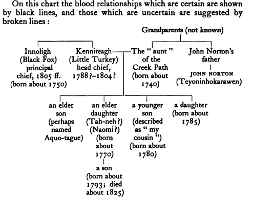
Pathkiller I and Pathkiller II
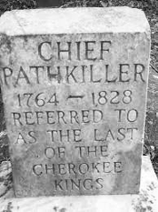
Adding to the confusion are the incorrect dates on the foot stone at the burial site in Centre, Alabama. The dates of 1764-1828 are wrong. This has led many to add a Pathkiller Jr (Pathkiller II) and family. For example, the marriage of Susan “Sookie” Martin to Chief Pathkiller, the Chief of the nation. This does not disprove that Susan Martin married a Pathkiller. Yet, the likelihood of a Pathkiller Jr. son of Chief Pathkiller, is not culturally correct. No historical records of a son named Pathkiller Jr or Pathkiller II can be found. Except Pathkiller Junr as previously noted.
The dates on the tombstone in Centre Alabama come from the Garrett family. Laura C. Blair and the Perry Funeral Home and Monument Company placed the stone in 1980. 8
She may have obtained the dates from Will I Martins’ Article from the Gadsden Times-News. First printed December 1951 and reprinted in the Coosa River News, 18 January 1952, page 1;
“Last of the Cherokee Chiefs Buried at Centre”.
Fifth paragraph;
A few years ago, Mrs. Jane Ingram, mother of Bob Ingram, sports editor of the Gadsden Times, wrote a history of Cherokee County for the Alabama Department of Archives and History and in it she gave some information about Chief Pathkiller that was authentic and very interesting.
She said he was the last of the great chiefs of the Cherokee tribes. He was born in 1764. . . . . . . lived in his old home near his ferry until his death 1828. He was buried in the family cemetery.
Mrs. Ingram does not give references for the dates. They are incorrect.
Eighth paragraph of Mr. Martin’s article;
His grave was unmarked until a few years ago when Hugh Cardon. . conducted a drive to raise funds for replacing a monument at the grave of the great and good Indian leader
The confusing statement of Will I Martin; “His grave was unmarked until a few years ago. . .raise funds for replacing a monument. . .” is interesting. This article has several errors. It is a very poor source.
The Chief had a marker of some kind.
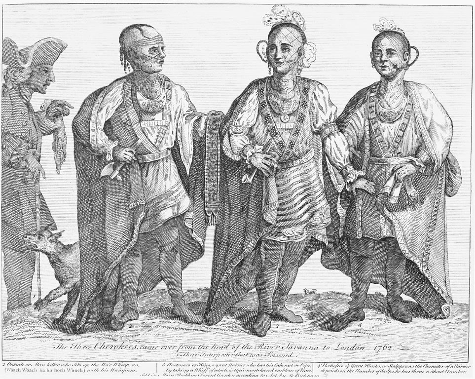
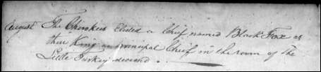
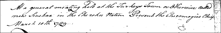
The Jacksonville Republican Newspaper in 1867 holds a reprint. This reprint is from an article that ran in the Gadsden Times-News in the first year of its publication, 1867. The article tells the story of the “Legend of Nahcullola or Black Creek Falls”. The story refers to Chief Pathkiller being “Laniska a young chief brave of heart and swift of foot, already distinguished in war and in peace.” (A name unsupported by any evidence in History. Chief Pathkiller would be in his 40s when he came to what is Turkey’s town in the mid-1780s). The footnotes are important references in this article.
After a long life he was gathered to his fathers. He now sleeps on the banks of the Coosa, a few miles above Nahcullola. A rude stone marks the spot and on it is the simple inscription – –
PATH KILLER, The Last King of the Cherokees. Path Killer’s Grave is in Cherokee County, on the North bank of the Coosa near Mrs. Garrett’s ferry. 9
The statement in 1867 indicates there is a rude stone that marks the grave. Chief Pathkiller had an original stone marker placed at his grave before 1867. “Path Killer The last King of the Cherokees”. The contrast in the statements on the stones should be noted. The present-day stone states; “Referred to as the Last of the Cherokee Kings”. This evidence should prove the present-day stone is possibly the 3rd stone marking the Chief’s grave.
Hugh Cardon also made this statement in the Coosa River News, 31 July 1936, page 2;
Tradition records that Pathkiller is buried on the Coosa River overlooking Turkey Town which appeared in the “Sentinel”, published in Cedar Bluff in 1841. 10
These early statements date back to 1841. They should provide solid evidence that Chief Pathkiller is buried in the Garrett Cemetery, Centre, AL. Is there further evidence that Chief Pathkiller is buried in the Garrett Cemetery? I will follow up on that. What about an estimated birth year and a death date?
Birth Year Estimate
There is only one historical document during the lifetime of Chief Pathkiller that gives us an estimated birth date.
A description of Chief Pathkiller at Charles R. Hick’s house on 2 November 1818 by Rev. Ard Hoyt;
On entering I observed the King seated on a rug, at one end of the room, having his back supported by a roll of blankets. He is a venerable looking man, 73 years old; his hair nearly white. 11
If the Rev. Hoyt is correct about the age, then the estimated birth year would be 1745.
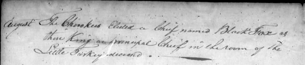
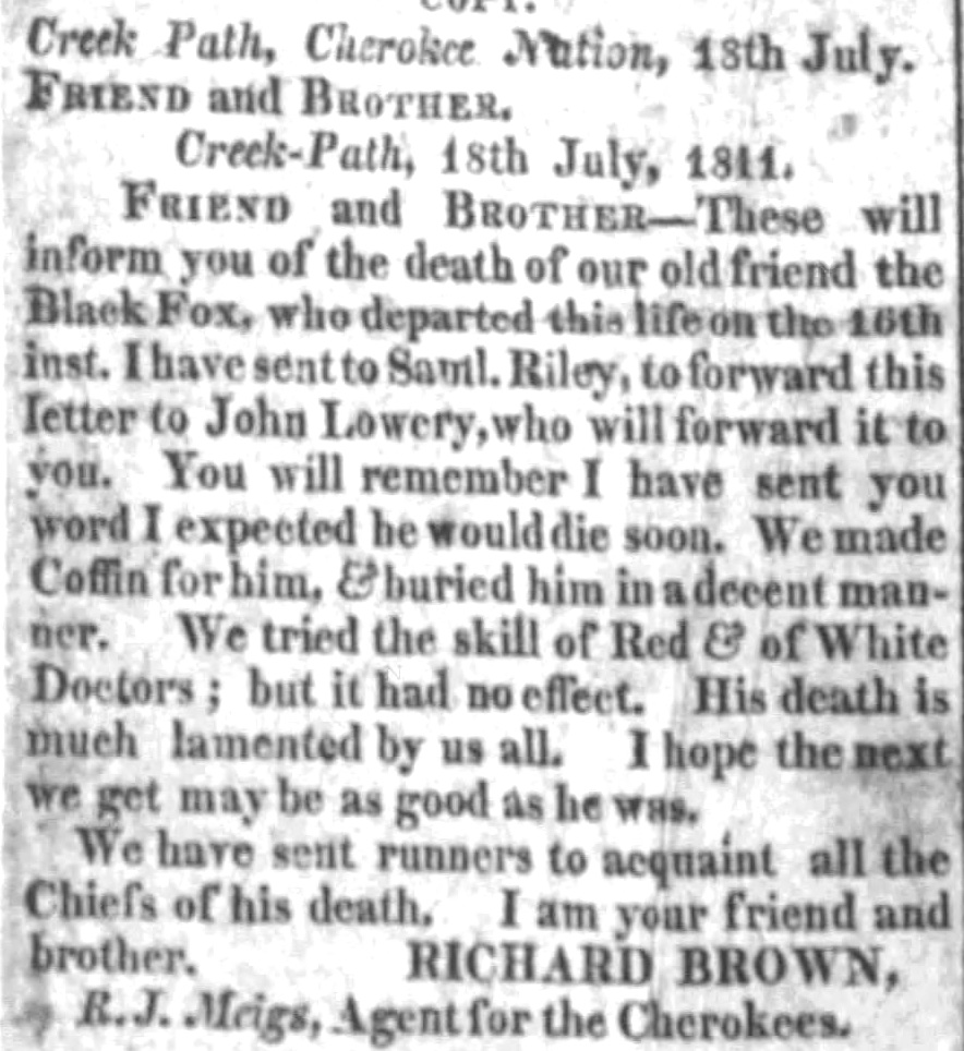
Cherokee Historian Grant Forman describes the death date.
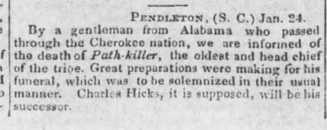
“Chief Pathkiller died, 8 January 1827 between 80-90 years of age”. 12
There are newspaper articles from the time period, of 1827 supporting the death date. 13
Also his death is recorded in “Records of the Moravian Among the Cherokees, vol. 7, pages 3582 and 3595; 3613-14
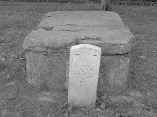
But there is a grave for Colonel Chief Pathkiller in New Echota, Calhoun, Georgia.
The state park of New Echota in Gordon County, Georgia, houses a burial site. It is marked by a US military stone. This stone was provided by the Veterans Affairs. The Women’s Club of Calhoun, Georgia, requested the stone with the assistance of US Congressman M. C. Tarver in 1931 15. The request did not have any citations. It only mentioned that Col Path Killer of Col Gideon Morgan’s Inf Reg, King of the Cherokees. The stone marking states Col Pathkiller, Morgan’s Cherokee Regt, War of 1812, 1742-1827. 16 The Chattanooga Daily Times, dated 27 Aug 1933, published in Chattanooga, Tennessee, features a photo on Page 30. It shows Robert Bruce Ross, the grandson of Chief John Ross, standing at the burial site of Col Pathkiller. The adjoining news article is about the arrest of the missionaries in Georgia. The tomb has a table rock encasement. No source citations were provided with the article or the application. 17 The military stone was ordered in 1931. The possibility of Chief Pathkiller being buried at this site is extremely low with the earlier proven information.
As of note. The grave site at the Garrett family cemetery is under consideration for certification as a Trail of Tears site. All paperwork is in process with the US Park Service Trail Division and National Trail of Tears Association. After certification, a formal correction to the dates will be placed at the grave site.
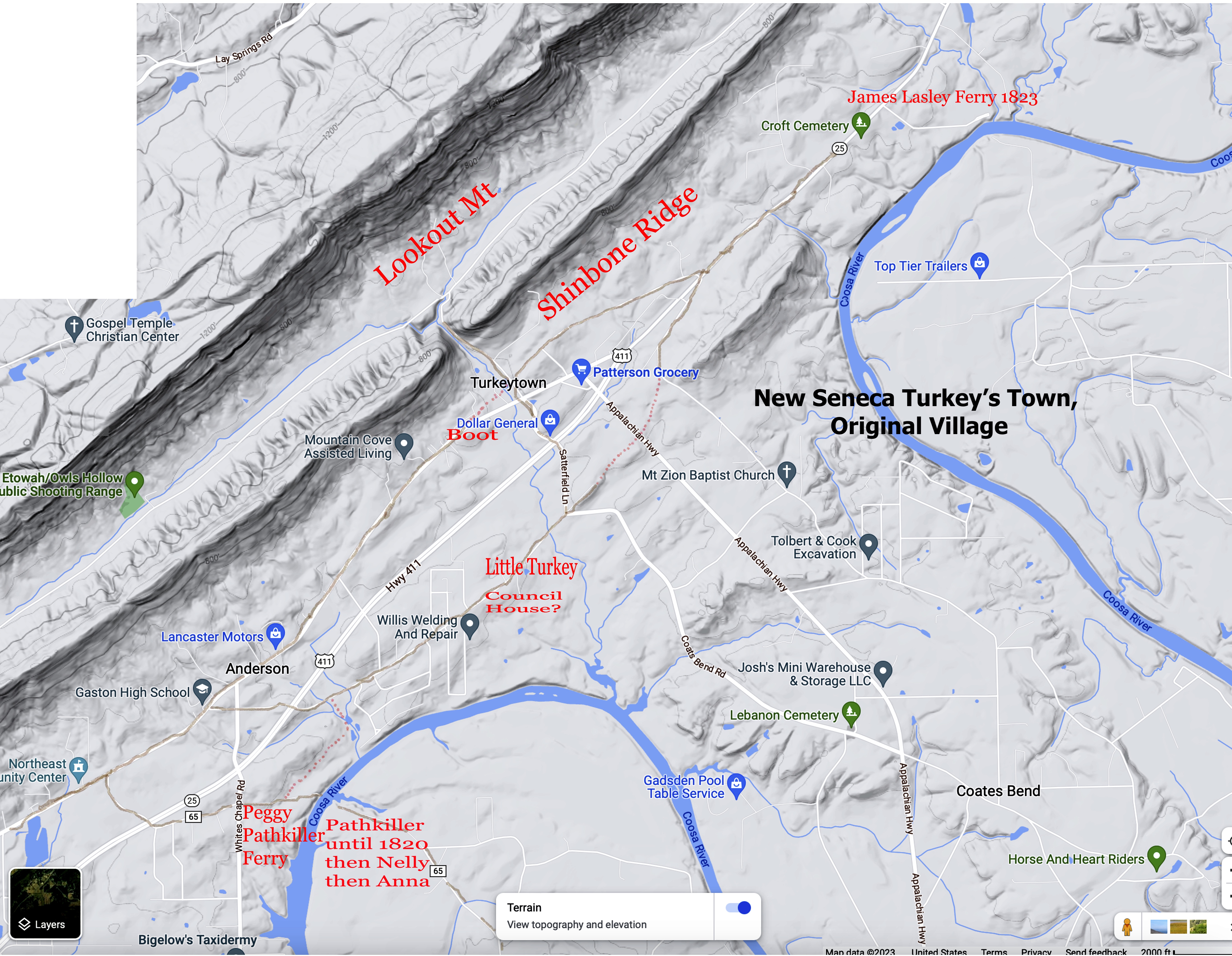
Proof Chief Pathkiller Died at His House
A court case at the Cherokee District Courthouse in Chattooga Town (North of present-day Gaylesville Al) provides information. It reveals where Chief Pathkiller was living when he died. Emphases added by this researcher.
Tah-ka-ha-kee & Crying Snake vs Robt Brown
Plaintiffs witness May 26th 1830
Ahnoah Deposeth and saith that she was living in the neighborhood of Gunters Landing when her uncle the Bears Meat told her that the Pathkiller wanted her the Deponent to come and live where the Pathkiller was clearing a place on the Couse River on the West Bank at Pathkillers Ferry so called; the Pathkiller told her that he would get some young men to build some houses, and bout one year after the Pathkiler brought the Hammer there with his mother the Pathkillers wife.
How long did the Pathkiller settle at the ferry? Ans; He lived there until he died.
Did he ever move opposite? Ans; No
Did he die where he was clearing? Ans; He died at the house.
Which side of the river did the Pathkiller die? Ans On the East side 18
Conclusion
Nancy, the child of Chief Pathkiller and Peggy, never married a man named Moore. Chief Pathkiller died at his house (present-day Centre, Alabama). There is no Pathkiller I. There is no Pathkiller II. There is no son of Chief Pathkiller named Junior. Pathkiller Junr is a designation on a Treaty. It indicates that there are two Pathkillers who sign. One is younger than the other. It is not a family relationship.
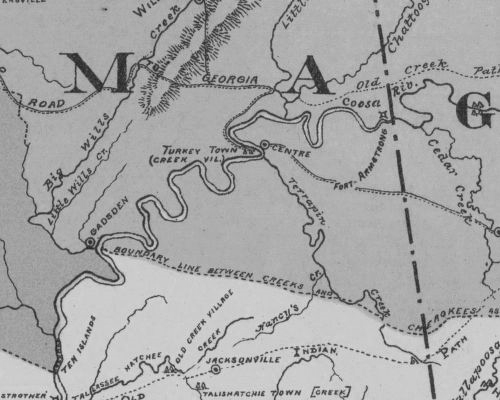
Chief Pathkiller the King, Principal Chief of the Cherokee Nation 1811-1827 lived in Turkey’s Town. He was born about 1745 and died in his house on the Coosa River (present-day Centre, Alabama). The date was 8 January 1827. He was buried near his house.
We will continue to explore this, Chief Pathkiller. He had at least 3 wives at separate times. Who can be proven as his family? His first resident, ferry, and fort in Turkey’s Town. He was referred to as King. He was promoted a Colonel in the US Army. The Creek War. The Treaty that was ratified at Turkey’s Town in 1816. His involvement with the missionaries. The Beloved Chiefs From Turkey’s Town.
- “The Legend of Pathkiller”. Manataka American Indian Council website https://www.manataka.org this web does not exist anymore. It has been copied by several on Ancestry.com using the information to link their families. This story can be found at;
http://betty-shirley.com/chief_pathfinder.htm The story can be found at Cave Springs blog as well from a 2012 post. http://cavespringga.blogspot.com/2012/08/the-legend-of-pathkiller-by-takatoka.html
↩︎ - Hargett, J. L.. Muster roll of John Benge detachment. 4026.707. John Ross Papers. September 28, 1838. Tulsa: Gilcrease Museum, https://collections.gilcrease.org/object/4026707 (02/19/2018). ↩︎
- Manuscript Collection #1787, Box 16, Folder 1 Tennessee State Library and Archives Microfilm Collection 815, Reel 6, 1842 Flint District Claims, Book 4, Claim #10, Crying Snake’s portion of claim is missing from the file. ↩︎
- https://www.pellcitylibrary.com/wp-content/uploads/2022/03/Native-Americans.pdf Pell City Library, Court Records Links, Estate Book B, Page 65, Page 23 in the library document. ↩︎
- Rice and McCoy/Rawlings and Massey’s Valuations, Cherokee County, Alabama, #44; Property Valuations, Entry 224; Records of the Bureau of Indian Affairs, Record Group 75; National Archives Building, Washington, DC. Annual Income $1,460.00 based on certificates of David Vann, James Lasley, Wm Childers and John Fields. Of the amount allowed Ridge received 1/8th of the whole for ferrying, 1/2 of the remaining balance, 3/8 of the other half. Of the remaining portion, Crying Snake received 1/8th, Hughston (Houston) received 2/8th , Tarkaga (Tarkahagee) received 1/8th , and the final 1/8th went to Nancy (Pathkiller), Crying Snake’s mother. ↩︎
- John Ridge was paid $10,615.61 on Volume A, p. 318. Crying Snake was paid $796.88 on Volume A, p. 14. Nancy was paid $798.88 on Volume A, p. 14. Houston was paid $1,593.75 on Volume B, p. 249. Tarkagee was paid $796.88 on Volume B, p. 269. Register of Payments, Entry 247; Records of the Bureau of Indian Affairs, Record Group 75; National Archives Building, Washington DC. ↩︎
- https://www.pellcitylibrary.com/wp-content/uploads/2022/03/Native-Americans.pdf Pell City Library, Court Records Links, Orphan Court March fifth 1833, Orphan Court Book, page 241, 1827-1844. Page 19 in the library document.
↩︎ - Interview with Billy Mack Garrett by this researcher, February 2024. ↩︎
- JACKSONVILLE REPUBLICAN (Jacksonville, Alabama) · 14 Sep 1867, Sat · Page 4
THE CHEROKEE ADVERTISER P. J. Smith, Editor, Centre, Alabama, Thursday, September 19, 1867, Volume- 2, No. 23.) Reprint articles from the Gadsden Times-News 1867. Newspaper.com ↩︎ - Newspaper.com; “The Will of Peggy Pathkiller”; The Coosa River News, Centre Alabama, Friday, 31 July 1936, page 2. ↩︎
- The Pansophist, and Missionary herald. v. 15 (1819). Journal of the Mission at Brainerd, page 42. https://babel.hathitrust.org/cgi/pt?id=nyp.33433068276272&view=1up&seq=64&q1=King ↩︎
- “The Daily Oklahoman” (Oklahoma City, Oklahoma) · Sun, Apr 18, 1937, · Page 78. “The Great Human Cattle Drive”, Grant Forman, Newspaper.com ↩︎
- The Susquehanna Democrat, Wilkes-Barre, Pennsylvania, 2 March 1827, Friday, page 3. The National Gazette, Philadelphia, Pennsylvania, 10 February 1827. ↩︎
- The National Gazette (Philadelphia, Pennsylvania) · 10 Feb 1827, Sat · Page 2, Newspapers.com ↩︎
- The Atlanta Constitution (Atlanta, Georgia) · 9 Nov 1930, Sun · Page 3, Newspaper.com ↩︎
- Headstone Application, https://www.fold3.com/image/318059724 ↩︎
- Did the Brainard Missionaries Advert Civil War, Chattanooga Daily Times (Chattanooga, Tennessee) · 27 Aug 1933, Sun · Page 30, Newspaper.com ↩︎
- Penelope Allen Johnson Collection, University Tennessee Knoxville, Series V, Box 1, FOLDER 201 ↩︎
Trust in the Lord with all your heart, and do not rely on your own understanding;
in all your ways know him, and he will make your paths straight. Proverbs 3: 5-6 CSV