• Home
  • About
  • Alabama Chapter Trail of Tears Association
  • National Trail of Tears Association
  • Local History

New Seneca Turkey's Town

~ Uncovering the History of Turkeystown, a Cherokee Village/Town in Northeast Alabama

New Seneca Turkey's Town

Tag Archives: New Seneca

The Beloved Chiefs from Turkey’s Town, Chulioa or The Boot

19 Tuesday Aug 2025

Posted by Jeffrey Sauls in Local History

≈ Leave a comment

Tags

alabama-history, cherokee-indians, native-americans, New Seneca, northeast-alabama-history, trail-of-tears, turkeytown

Chulioa or The Boot1 is not a “Beloved Chief” to the Cherokee Nation. He is not a Chief. He is one of the most important people in Turkey’s Town. He is listed as one of the “Headman” of Turkey’s Town. This is how he is listed at the Grand Council meeting on 1 June 1792.

Present, the Little Turkey, great beloved man of the whole nation; the Badger, the beloved man of the Southern division; the Hanging Maw, beloved man of the Northern division; the Boot, the Black Fox, the Cabin, Path Killer, head-men of Turkey’s town.2

Chulioa was raised in a Creek village. The Reverend Daniel Butrick, born in Massachusetts, did not understand his title. Butrick did appreciate his importance.

3. See transposed below
4 See transposed below

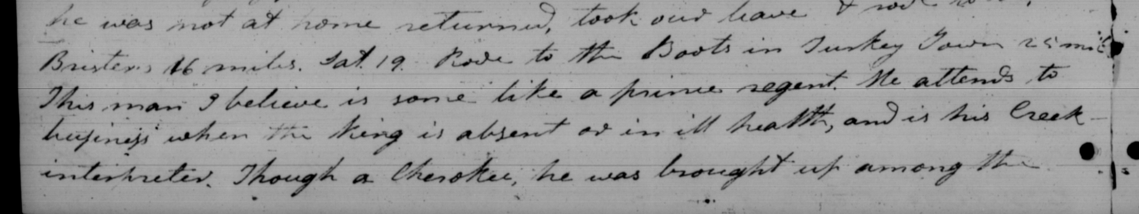
“This man I believe is some like a prince regent.  He attends to business when the king is absent or in ill health, and is his Creek interpreter.  Though a Cherokee, he was brought up among the Creeks, and though he now lives with the Cherokees & is one of their principal Chiefs, yet he is also a chief, and attends councils of the Creek Nation.  He can neither talk nor understand English, and yet perhaps few men in any nation understand the art of pleasing & of rendering their company pleasant and agreeable better than he.”  5

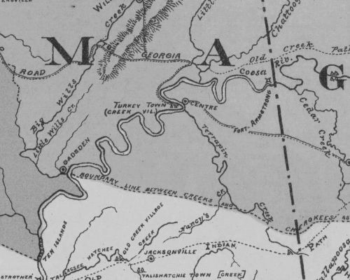
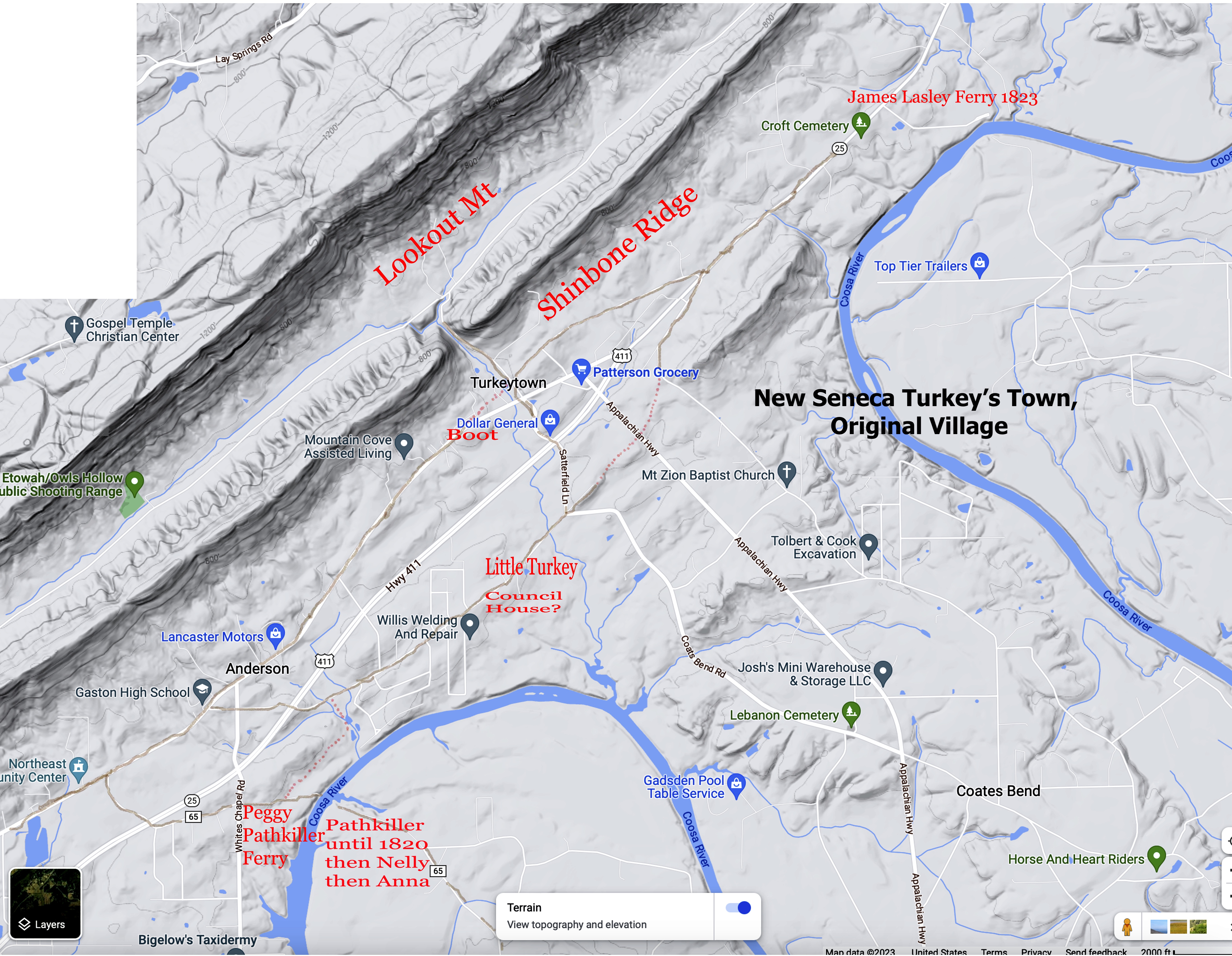
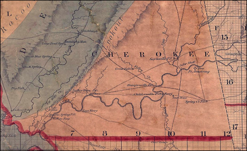
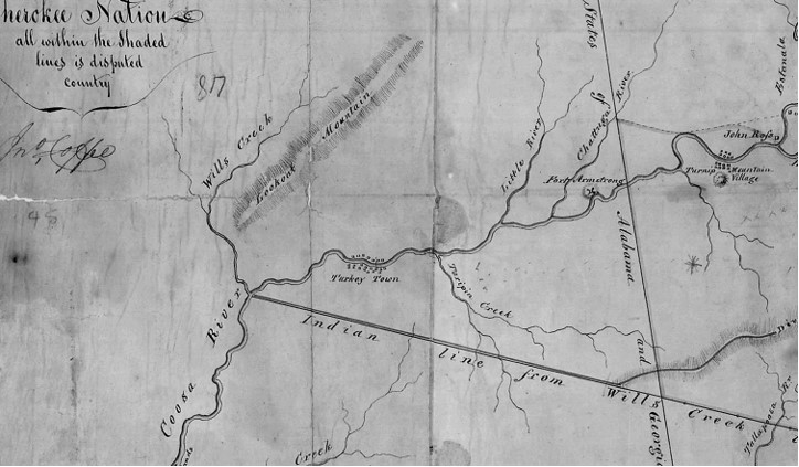
Chulioa served as an advisor and Creek interpreter to Principal Chief Little Turkey6. He led Chief Little Turkey to a location for his village. Turkey’s Town was the first settlement of the Cherokee in the Creek territory. (Now Northeast Alabama.) Review, archive, 12 February 2025, post, Location by the People of Turkey’s Town. Settlement of Turkey’s Town is one of the most important events in Northeast Alabama’s history during the 18th century. The following is found in the Alabama Territories Papers.

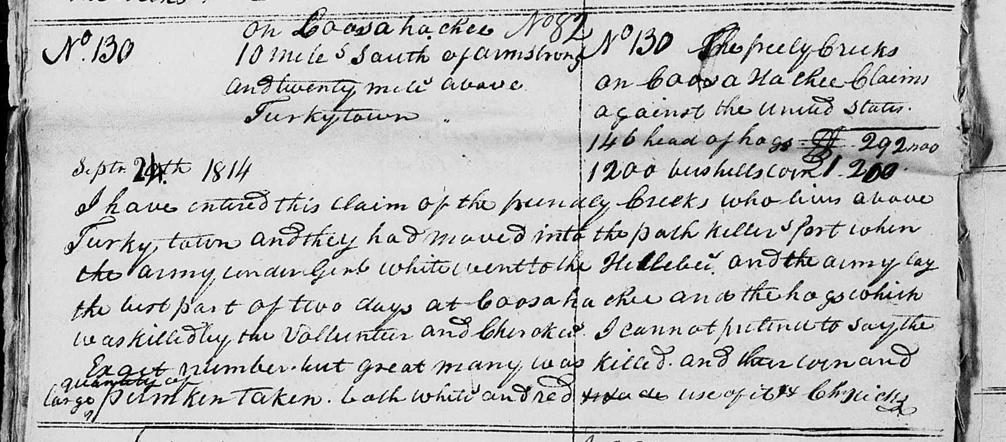
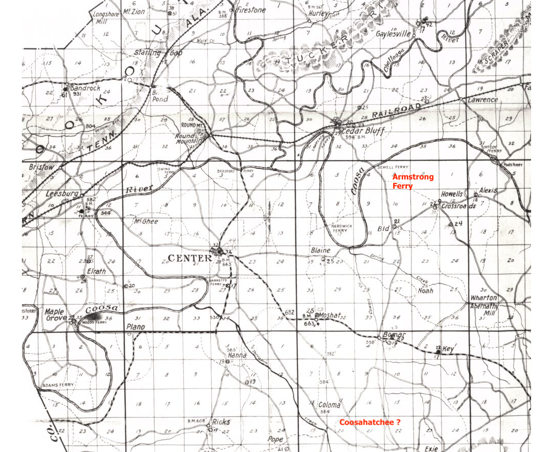
There is a track of land lying on Wills Creek and between that creek and the Coosa River on the West side of the latter, and north of the Treaty line of Fort Jackson which they may be prevailed upon to part with, in treating for which they are willing to discuss and settle the subject of the boundary between them and the Cherokee. They however contend that their present boundary with the Cherokee is by the Suwannee path where it leaves the Western line of Jackson County to the old town on the Chatahotchie River and from thence by a drift line to the Mouth of a certain water course called by them, Little River where it unites with the Coosa. They have furnished me with a copy of certain question put by the Creeks to an old Cherokee Chief and the Cherokee Interpreter (who was their mutual interpreter on the first settlement of the Cherokee in the Creek Country) . . .7

This has to be Chief Little Turkey and Chulioa.

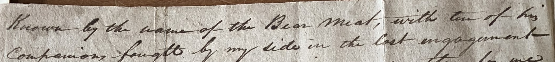
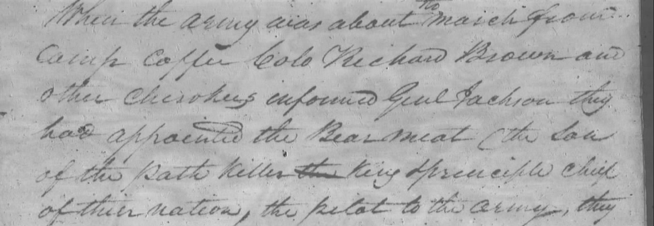
Chulioa played a very important role in the Creek War, 1813-1814. His service in the Creek War was significant to Chief Pathkiller and the US. Chulioa served as the Creek Interpreter. We see in Dr. Susan M. Abram’s Doctoral Dissertation titled Souls in the Treetops, Cherokee War, Masculinity and Community, 1760-1820. She received her Doctor of Philosophy from Auburn University in 2009. Footnote 27, page 118, Cherokee Muster Rolls, RG 94, AGO. Jackson personally oversaw the mustering in of Pvt. Chulio, who was Path Killer’s aid. He served as a private under Capt. James Brown for his first tour of duty. During his second tour, Chulio earned a promotion to 1st Lt. under Capt. Frog.  The footnote is attached to these sentences. Intelligence gathered by the Creek interpreter Chulio soon indicated that a considerable force of Red Sticks had gathered near Ten Islands on the Coosa River while others were about forty miles south of Tuckabatchee. Another group was at Oakchoi Town, not far from Turkey Town near the Creek-Cherokee border.

Chulioa should not be confused with another Cherokee warrior who was killed during the Creek War. The Boot. This Boot was in Captain McLemore’s Company. 8

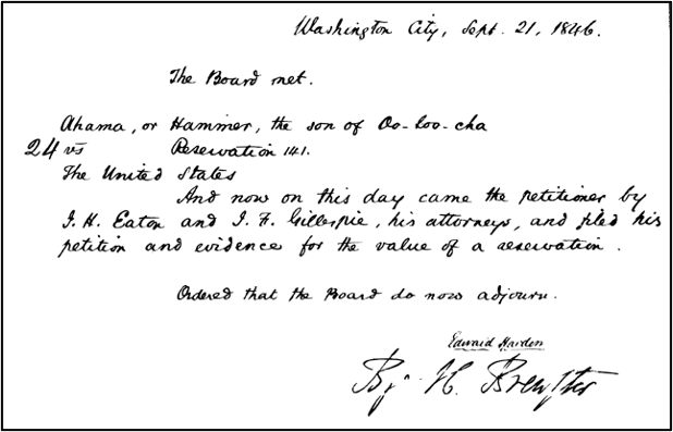
Chulioa made his mark on the Treaty Ratified in Turkey’s Town in October 1816.9

Chulioa will be the go-to guy in Turkey’s Town. Rev. Butrick would go to him to gain a meeting with the headmen and Chief Pathkiller in 1822.

Friday 18th. With Br. John Arch started for Turkey’s Town where we arrived on Saturday evening, and called on the Boot.  He is the King’s Creek interpreter & one of his confidential consellors.  I told him the object of our journey, and that if he saw fit to notify a meeting we should be pleased to see the king – Path Killer, and all the people of the town together.  He seemed thankful and said he would lay the subject before the head men of his Town, and let us know their minds.10

Conclusion

Chulioa or the Boot is a very important person in Turkey’s Town. He is the link to how Chief Little Turkey would settle there. He was very involved with the Creek War. Next post we will see his family and their connections in the Cherokee Nation. We will see a very tragic part of the Trail of Tears.

  1. His name is rendered by English writers as Chuleoa, Chulioa, Chuli-o-a, Chulcoh, Tsu-le-o-a, Chutcoe, or generically as ‘the Creek interpreter’ ↩︎
  2. Indian Affairs, Volume 1, ASP IA Vol. 1, searchable online the Library of Congress American State Papers web site, pages 271-273, 26 June – 1 July 1792. ↩︎
  3. 19 Jan 1822, Journal of Reverand Daniel S. Butrick, pages 143-2, 143-3, American Board of Commissioners for Foreign Mission (ABCFM), 18.3.1 V3, Michael Wren personal copy. Original and transposed copy. ↩︎
  4. Ibid ↩︎
  5. Ibid. ↩︎
  6. See American State Papers Vol 1 pp 271, 276, 277, 328, 447, 657.  See also American State Papers Vol 2 pp 145, 153-154 (where is incorrectly called ShoeBoots), 283, 486-487, 489-490.  He was one of the headmen of Turkey’s Town and part of the Cherokee leaders at the signing of the Treaty of Holston of 1791 where he delivered an address.  See Lyman Draper Papers 15 U 5-56.  Specifically, see 35-36 & 39-46.   ↩︎
  7. Alabama Territory, Territorial Papers, pages 183-184, images 207-208, https://babel.hathitrust.org/cgi/pt?id=mdp.39015010692468&seq=208 page183-184 ↩︎
  8. Dr. Susan M. Abram’s Doctoral Dissertation titled Souls in the Treetops, Cherokee War, Masculinity and Community, 1760-1820. Doctor of Philosophy from Auburn University in 2009. Page 228 ↩︎
  9. National Archives, Record Group 11, General Records of the United States
    Government, Series Indian Treaties; RIT #83; Ratified Indian Treaty #83,
    Cherokee, Chickasaw Council House, September 14, 1816. There are 231 images
    of this with correspondence of letters and a journal. https://catalog.archives.gov/id/100220646 ↩︎
  10. 18 Jan 1822, Journal of Reverand Daniel S. Butrick, American Board of Commissioners for Foreign Mission (ABCFM), 18.3.1 V4, Unit 6, reel 754 1819-1845, Michael Wren personal copy. Original and transposed copy. ↩︎

Trust in the Lord with all your heart, and do not rely on your own understanding; in all your ways know him, and he will make your paths straight. Proverbs 3: 5-6 CSV

The Beloved Chiefs From Turkey’s Town, Chief Pathkiller, his family

17 Tuesday Jun 2025

Posted by Jeffrey Sauls in Local History

≈ Leave a comment

Tags

alabama-history, cherokee-indians, Chief Pathkiller, native-americans, New Seneca, northeast-alabama-history, Pathkiller, trail-of-tears

Mr. R. S. Cotterill states in the Preface of his book, “The Southern Indians”; 

“The Southern Indians . . .the records of their history are records by whites and are marred by prejudices and misunderstandings.1

The above statement is so true. When we review Chief Pathkiller on genealogical websites, the information is so confusing. It is full of speculations, misunderstandings, incorrect information, and made-up fill-ins. It is worth stating again that Pathkiller is not a surname. That everyone who is referred to as Pathkiller is not the King, or Principal Chief Pathkiller (Principal Chief 1811-1827). That they are not all related as family. What can be proven? The genealogical websites have very few historical source citations. Most of what is referred to is from a modern-day history article. Some are from history books. What can be proven?

Proven

Chief Pathkiller’s parents can not be proven. They are unknown. Shelia Ford, a descendant of Nancy Ward, led me to new information on Moytoy. “Nunnadihi Pathkiller, Pathfinder Moytoy is a fictional name for the real Pathkiller.” 2

“In the summer of 2018, the Cherokee Heritage Center removed all mention of an alleged Moytoy family from their website. They determined that the fictional Amatoya/Amadoya Moytoy had not existed. James Hicks, from whom the incorrect information appears to have come, had hypothesized that all Cherokee came from a single ancestor. He named that fictional ancestor Amatoya/Amadoya Moytoy with no evidence or documentation whatsoever.” 3

If Chief Pathkiller’s parents are unknown, what can be proven about his family?

Chief Pathkiller has at least three wives.

The first wife’s name is unknown. They had three sons and one daughter. These children show up in historic documents and are not guesses. The first son is Bearmeat. It must be stated again that not everyone whose name is Bearmeat is the son of Chief Pathkiller. There are discussions on genealogical websites. They include correspondence of Chief Pathkiller talking about his son in the Creek War (1813-1814). Several of them state this must be Pathkiller II or Junior. There is no Pathkiller II or Junior as a son.

Bearmeat served under Gen. Cocke with Gen. Andrew Jackson in the Creek war. Bearmeat served as a scout for General Cocke. Gen. Cocke wrote a letter commending Bearmeat. “the son of the old Path Killer known by the name of Bear meat,.”4

Major Robert Searcy in a letter to Gen. John Coffee commends Bearmeat as well; “Bearmeat the son of the Path Killer king & principle Chief of their nation.”5

Bearmeat settled in the Creek Path (Guntersville, Alabama). He would have his own town Southwest of Creek Path.

Whitemankiller is another son. He is reported in Richard Blount’s journal while surveying the Georgia-Alabama boundary. “1 September 1826 met a Cherokee named Whitemankiller, wife, and daughter. . . Charles Hicks had sent a runner to his father Pathkiller.”6

James Lasley states the names of Whitemankiller’s children with their mothers in a deposition about their reservation. Lasley stated that Whitemankiller died in 1823 on his reservation at Turnip Mountain, Coosa River, Georgia. Whitemankiller’s family was disposed of the 320 acres in 1834-35. Lasley states his death date is “best of my recollection”. The dates conflict. This creates a plausible date of after 1826 and before the forced removal from the land of 1834.

 “ Soo-wagi . . . Tahnuh-cas-tat-he, Oo-nee-skoo-koo and Thi-ah-muh-nuh children of White Man Killer and Joh-Ke-die;: Tee-sak-ni whose mother is deceased and Jackson, Mary heir of Buck Deceased;: Scott and Choo-wah-nas-kee and Peter children of Whit Man Killer and Yoo-yas-ki also decease.”7

A final son Tah-ka-ha-kee is listed on the Rice and McCoy/Rawlings and Massey’s Valuations, Claims, Cherokee County, Alabama, claim #44, property valuations, entry 224; Records of the Bureau of Indian Affairs, Record Group 75; National Archives Building, Washington, DC.

“Of the remaining portion, Crying Snake received 1/8th, Hughston (Houston) received 2/8th, Tarkaga (Tah-ka-ha-kee) received 1/8th, and the final 1/8th went Nancy (Pathkiller), Crying Snake’s mother.”8 John Ridge received the other 3/8. This is with Chief Pathkiller’s estate on the Coosa River (Centre, Alabama, Garrett Ferry).

Tah-ka-ha-kee is not mentioned in any of Peggy’s estate.

Unknown named daughter, sister to Bearmeat

 Ahnoah stated in her Chatoogga District Court deposition that Bearmeat was her uncle. Cherokee culture would place Bearmeat as the brother of Ahnoah’s mother.                                                                                                  

Plaintiffs witness May 26th 1830 Ahnoah Deposeth and saith that she was living in the neighborhood of Gunters Landing when her uncle the Bears Meat told her that the Pathkiller wanted her the Deponent to come and live where the Pathkiller was clearing a place on the Couse River on the West Bank at Pathkillers Ferry so called; the Pathkiller told her that he would get some young men to build some houses, and bout one year after the Pathkiller brought the Hammer there with his mother the Pathkillers wife.9

Wife Peggy a Cherokee woman

Peggy is one of Chief Pathkiller’s wives. She has a will drawn up for her in 1829. Did issues over Chief Pathkiller’s estate at the new ferry cause this? Were improvements at the new ferry a factor in needing “White man’s court?” A lot of the genealogical websites have her death date based on this record. The “will” was submitted on 13 March 1829. Chief Pathkiller died in 1827. Issues with his estate (Garrett Ferry, Centre, Alabama) went to court in May 1830. Peggy’s will was probated on 14 March 1833.10

Peggy is listed as part-owner of a ferry near Turkey’s Town. It states they were “dispossessed since the spring of 1832”. She died sometime between this time and March 1833. She is buried somewhere on the property.

George Chambers, John Ratliff, Daniel Griffin Jr., and Peggy Pathkiller Sr were joint owners of a Ferry on the Coosa River in Turkey Town Valley, Cherokee County.  The Valuations gave an average annual income of $100.00.  Included with this Valuation were a 16’x14’ house and a 10-acre field of bottom land under fence.  The Claimants were dispossessed since spring of 1832.11

Five Daughters

We have discussed Nancy. To review. Nancy is listed in Peggy’s will “to my oldest daughter Nancy“. Nancy’s sons Crying Snake and Eyoostee, also known as Houston are listed in the will; “To my grandson Crying Snake. To my grandson Eyoostee.”

Nancy on oath states that she lived at the house of Crying Snake for a great number of years, and therefore she confirms his statement with regards to his claim.12

Register of Payments, Book A. Page 14; Crying Snake and Nancy are paid for their portions of Pathkiller’s ferry; #12, Crying Snake, Alabama, Ferry on the Coosa, share of C. Snake $796. 87 ½   Sent West Jany 1839; #13, Nancy. Crying Snake’s mother.   Ferry on Coosa, Share for Nancy $796. 87 ½  Sent West Jany 1839.
 
St Clair County; Special Orphans Court, October 1833, page 241; October 31st 1833. . .  settlement had on the Estate of Peggy Pathkiller Deceased the papers and vorchers being filed in office. . . Nancy one of the heirs receipt $455.00. Crying Snake one of the heirs receipt $450.00.  Eustee one of the heirs receipt $300.00. 13

Nancy Pathkiller, Crying Snake, and Houston are listed in the Captain John Benge14 Detachment. They left Fort Payne in September 1838. They arrived in the West in January 1839 on the “Trail of Tears”.

Nelly or Nella is listed in Peggy Pathkiller’s will; “to my daughter Nelly. . .”15

Special Orphans Court, October 1833, page 241; October 31st 1833. . . settlement had on the Estate of Peggy Pathkiller Deceased the papers and vorchers being filed in office. . . Nelly one of the heirs receipt $375.00 16

Nelly is possibly the N. Pathkiller of Turkey Town listed in Forman’s 1835 Cherokee Census.  She is listed on page 80; 5 fullbloods, one farmer, 3 readers of English, 1 weaver, 1 spinster (spinner).Nelly is listed in the Benge Detachment for the “Trail of Tears”.  Nelly has a daughter named Anna. Anna married Frances Hampton.

Quatee is listed in Peggy Pathkiller’s will; To my daughter Quatee. .  .17

Special Orphans Court, October 1833, page 241; October 31st 1833. . . settlement had on the Estate of Peggy Pathkiller Deceased the papers and vorchers being filed in office. . . Quata one of the heirs receipt & George Campbell one of the heirs} $1200.00.18

Quatee married George Campbell. George Campbell is listed on the Lieutenant Edwards Deas detachment. They left for the West on 6 June 1838. Their departure point was near Ross Landing on the Tennessee River.19

Charwahyooca is listed in Peggy Pathkiller’s will; to Charwahyooca my daughter. . .20

Special Orphans Court, October 1833, page 241; October 31st 1833. . . settlement had on the Estate of Peggy Pathkiller Deceased the papers and vorchers being filed in office. . . Charwahyooca and Richard Ratliff receipt $300.0021

She married Richard Ratliff Jr. Richard Ratliff Jr. is listed on the Lieutenant Edwards Deas detachment. They left for the West on 6 June 1838 near Ross Landing on the Tennessee River. 22

I will share more on the Ratliff family. Not because they married into Chief Pathkiller’s family, but their involvement in the Turkey’s Town Story.

Jenny is listed in Peggy Pathkiller’s will; my youngest daughter Jenny. . .I also Shall leave. . .House its furniture and plantation. . .who lives with me in the same house this property. . .23

Special Orphans Court, October 1833, page 241; October 31st 1833 . . . .settlement had on the Estate of Peggy Pathkiller Deceased the papers and vouchers being filed in office. . . Jenney one of the heirs receipt $1188.60 24

Jenny “Jane” Pathkiller was listed in the Captain John Benge Detachment. They left Fort Payne in September 1838. They arrived in the West in January 1839 on the “Trail of Tears”. 25

Dragging Canoe. He is not to be confused with the Chickamaugan Chief who died in 1794. He is the only male sibling of the women above. The girls named him in affidavits about Anna Hampton’s improvement claims in 1837 as their brother. Anna is the daughter of Nelly.

26

Dragging Canoe died before August 1829. The heirs with the Administrators of his estate sued in the Cherokee Supreme Court his mother, Peggy. This was over slaves Simon and Phoebe with her children, and some other property. St Clair County, Alabama Orphans’ Court Records show that James G Carrol received the appointment as Administrator. He was responsible for the estate of Dragging Canoe. Dragging Canoe was a Cherokee. The appointment was made in the 1833 term (page 207). Also appointed were David Gage, Thomas Machen, and James C Street.27 They were appraisers of the estate. There are no copies of the estate records on the internet.

Dragging Canoe may have been murdered. Chief Pathkiller complained to Rev. Daniel Butrick in 1822 about the murder of a son. His complaint was that the US President had done nothing about it. Butrick’s Journal. This will be discussed further in a discussion on Charles, Chief Pathkiller’s nephew. Charles was murdered in 1821.

Dragging Canoe was married to Watty, a Cherokee Woman. He had a son, Sky-ah-too-ka, and a daughter, Martha. Sky-ah-too-ka contested the improvements claimed by Anna Hampton. You can review this by looking back at the section, “Location by Chief Pathkiller’s family”.

Third Wife

Oo-loo-cha, a Cherokee Woman. 

“Ahama, or Hammer, the son of Oo-loo-cha”

“after the treaty of 1819, she (Oo-loo-cha) married Path-killer the chief of the nation and she abandoned her reservation and moved with him to Turkey-town”. 28

Conclusion

“My granny says that her granny was a Cherokee Princess.”

The information on the genealogical website for Chief Pathkiller is full of folklore, family traditions, and wishful thinking. The sources are written histories. Some are just stories. One needs to ask, “How do you know this?” “What is the source?” I hope what you have read here helps explain the proven family of Chief Pathkiller.

We will continue the discussion on Chief Pathkiller. The Beloved Chiefs from Turkey’s Town, Pathkiller, the Last King of the Cherokees. Next time.


  1. The Southern Indians, The Story of the Civilized Tribes Before Removal”, R. S. Cotterill, Norman and London, the University of Oklahoma Press, 1954, page IX Preface.
      ↩︎
  2. https://www.familysearch.org/en/tree/person/collaborate/LY36-VTS ↩︎
  3. https://www.indianreservations.net/2017/10/moytoy-of-tellico-emperor-of-cherokee_22.html#google_vignette ↩︎
  4. Hargrett Rare Book and Manuscript Library, The University of Georgia Libraries, Telamon Cuyler Collection, Box: 77, Folder: 30, Document: 02. ↩︎
  5. Fold3 Ancestry.com, Correspondence and Miscellaneous Records; page 271-274, Records of the Cherokee Indians Agency in Tennessee 1801-1835, Record Group 75, National Archive ↩︎
  6. Richard Blount’s Papers, Alabama State Archives, digital.archive.gov site, page 9 August 30-September 6, 1826 ↩︎
  7. 4th Board Claims, Entry 250, Image 199; Records of the Bureau of Indian Affairs, Record Group 75; National Archives Building, Washington DC. ↩︎
  8. Rice and McCoy/Rawlings and Massey’s Valuations, Cherokee County, Alabama, #44; Property Valuations, Entry 224; Records of the Bureau of Indian Affairs, Record Group 75; National Archives Building, Washington, DC. Annual Income $1,460.00 based on certificates of David Vann, James Lasley, Wm Childers and John Fields. Of the amount allowed Ridge received 1/8th of the whole for ferrying, 1/2 of the remaining balance, 3/8 of the other half. Of the remaining portion, Crying Snake received 1/8th, Hughston (Houston) received 2/8th,Tarkaga (Tarkahagee) received 1/8th, and the final 1/8th went to Nancy (Pathkiller), Crying Snake’s mother. This is the present-day Garrett Ferry site 1 mile South of Centre on the Coosa River. Now County Road 20.  ↩︎
  9. Penelope Allen Johnson Collection, University Tennessee Knoxville, Series V, Box 1, FOLDER 201 ↩︎
  10. https://www.pellcitylibrary.com/wp-content/uploads/2022/03/Native-Americans.pdf Pell City Library, Court Records Links, Estate Book B, Page 65, Page 23 in the library document. ↩︎
  11. Rice and McCoy/Rawlings and Massey’s Valuations, Cherokee County, Alabama, #49; Property Valuations, Entry 224; Records of the Bureau of Indian Affairs, Record Group 75; National Archives Building, Washington, DC.  The $1,100 total allowance was divided among the four partners.  ↩︎
  12. Manuscript Collection #1787, Box 16, Folder 1 Tennessee State Library and Archives Microfilm Collection 815, Reel 6, Flint District Claims, Claim #10, Crying Snake’s portion of claim is missing from the file. ↩︎
  13. https://www.pellcitylibrary.com/wp-content/uploads/2022/03/Native-Americans.pdf Pell City Library, Court Records Links, Orphan Court March fifth 1833, Orphan Court Book, page 241, 1827-1844. Page 19 in the library document. ↩︎
  14. Hargett, J. L.. Muster roll of John Benge detachment. 4026.707. John Ross Papers. September 28, 1838. Tulsa: Gilcrease Museum, https://collections.gilcrease.org/object/4026707 (02/19/2018). ↩︎
  15. https://www.pellcitylibrary.com/wp-content/uploads/2022/03/Native-Americans.pdf Pell City Library, Court Records Links, Estate Book B, Page 65, Page 23 in the library document. ↩︎
  16. https://www.pellcitylibrary.com/wp-content/uploads/2022/03/Native-Americans.pdf Pell City Library, Court Records Links, Orphan Court March fifth 1833, Orphan Court Book, page 241, 1827-1844. Page 19 in the library document. ↩︎
  17. https://www.pellcitylibrary.com/wp-content/uploads/2022/03/Native-Americans.pdf Pell City Library, Court Records Links, Estate Book B, Page 65, Page 23 in the library document. ↩︎
  18. https://www.pellcitylibrary.com/wp-content/uploads/2022/03/Native-Americans.pdf Pell City Library, Court Records Links, Orphan Court March fifth 1833, Orphan Court Book, page 241, 1827-1844. Page 19 in the library document. ↩︎
  19. Cherokee Registry Trail of Tears-Deas detachment, Cherokeeregistry.com ↩︎
  20. https://www.pellcitylibrary.com/wp-content/uploads/2022/03/Native-Americans.pdf Pell City Library, Court Records Links, Estate Book B, Page 65, Page 23 in the library document. ↩︎
  21. https://www.pellcitylibrary.com/wp-content/uploads/2022/03/Native-Americans.pdf Pell City Library, Court Records Links, Orphan Court March fifth 1833, Orphan Court Book, page 241, 1827-1844. Page 19 in the library document. ↩︎
  22. Cherokee Registry Trail of Tears-Deas detachment, Cherokeeregistry.com
      ↩︎
  23. https://www.pellcitylibrary.com/wp-content/uploads/2022/03/Native-Americans.pdf Pell City Library, Court Records Links, Estate Book B, Page 65, Page 23 in the library document. ↩︎
  24. https://www.pellcitylibrary.com/wp-content/uploads/2022/03/Native-Americans.pdf Pell City Library, Court Records Links, Orphan Court March fifth 1833, Orphan Court Book, page 241, 1827-1844. Page 19 in the library document. ↩︎
  25. Hargett, J. L.. Muster roll of John Benge detachment. 4026.707. John Ross Papers. September 28, 1838. Tulsa: Gilcrease Museum, https://collections.gilcrease.org/object/4026707 (02/19/2018). ↩︎
  26. Records of the Bureau of Indian Affairs, Record Group 75; National Archives Building, Washington DC, E236 Misc Claims Papers Image 584 ↩︎
  27. https://www.pellcitylibrary.com/wp-content/uploads/2022/03/Native-Americans.pdf Pell City Library, Court Records Links, Orphan Court March fifth 1833, Orphan Court Book, page 207, 1827-1844. Page 18 in the library document. ↩︎
  28. Hammer filed a claim several times to be paid by the US government for the improvements after he was in the Arkansas territory. Minute Docket 4th Board of the 
    Cherokee, claim #24 Reservation 141, September 21, 1846, Records of the Bureau of Indian Affairs, Record Group 75; National Archives Building, Washington DC ↩︎

Trust in the Lord with all your heart, and do not rely on your own understanding;
 in all your ways know him, and he will make your paths straight. Proverbs 3: 5-6 CSV

Uncovering the History of Turkeytown, Pathkiller’s Ferry.

04 Tuesday Mar 2025

Posted by Jeffrey Sauls in Local History

≈ Leave a comment

Tags

Centre Alabama, cherokee-indians, Chief Pathkiller, native-americans, New Seneca, northeast-alabama-history, Pathkiller Ferry, Pathkiller Grave, trail-of-tears, turkeytown

In the last post, we proved that Chief Pathkiller lived in Turkey’s Town. He had a ferry on the Coosa River. We saw that a fort was built around his residence. His wife Peggy would keep this ferry. His children would live on the property on both sides of the Coosa River. All of this is in Etowah County, Alabama, Near Gaston School on US 411 North. It confirms the original location of Turkey’s Town.

New Improvement

This post explains Chief Pathkiller move. “One mile south of present day Centre.” We learn of a new wife and an illegal sale of part of his estate. Additionally, let’s look at the dispute between the Garrett Family and John Ridge. John Ridge acquired most of Chief Pathkiller’s estate at the Centre, Alabama location. Uncovering the History of Turkeytown, Pathkiller’s Ferry.

The affidavit of James Lasley. “The grandfather of this claimant Anna Pathkiller being the person who made the first improvement and kept it and held it legally as his according to the Law and usage til about the year 1815 ”

What happens? Did Peggy send him packing? Did he abandon the family? What was going on in history at this time?

Influx of White People

Chief Pathkiller became the “King” or Principle Chief in 1811 after Black Fox’s death. The Creek war ended in 1814. During that time, “Friendly Creek” was living at Chief Pathkiller’s cabin. A “fort” was built around it. A treaty ratification took place at Turkey’s Town in October 1816. The US Army, under the command of Maj Gen. Andrew Jackson, came to sign this treaty. (The 1816 Turkey Town Treaty is a post later.) The US government signed treaties in 1817 and 1819.

The Creek War brought the US Army, that was made up of Tennessee Volunteers. There were mixed families in the Cherokee people. They have married white people. But now, it must have felt like an invasion of strangers taking everything. Friendly Creeks living in the front yard. The yard had been fortified. Two years later, more soldiers. Andrew Jackson came with an escort for the treaty signed in 1816. The 1816 treaty strongly talks about moving the whole nation West of the Mississippi River. Is this more than Peggy wanted?

Oo-loo-cha, the New Wife

It is the custom of the Cherokee people that the female controls the marriage. Peggy might have dissolved the marriage. We do not have a clue as to what happened. We do know that the separation happened between 1815 and the Treaty of 1819. His daughter Nelly told James Lasley about 1815. (See Lasley’s statement above.) Hammer, the son of Oo-loo-cha, stated 1819, see below.

Al 19 4th Board of MD, Vol 1, pages, 13-14,45,189-190-191, Ahamah #24 Claim

“after the treaty of 1819, she married Path-killer the chief of the nation, abandoned her reservation and removed with him to Turkey-town.”

The above two selections of Hammer’s 1846 claim are based on his mother’s reservation. Chief Pathkiller married Oo-loo-cha just after the 1819 treaty.1 Hammer’s father is Fawn Killer, and he died before 1819.

The claim by Hammer is on the estate or improvements last held by Pathkiller. This is the ferry and property at Terrapin  Creek today’s Centre, Alabama. Hammer sold part of this estate to a white man named Robert Brown.

Michael Wren discovered a file box on Pathkiller. This was in the collection of Penelope Allen Johnson. It was located at the University of Tennessee in Knoxville. There were several folders about a dispute in the Cherokee District Court at Chattooga. This court was located just Northeast of today’s Gaylesville, Alabama. By Cherokee law, to settle disputes between the people, it was done in the Cherokee district court.

Tah-ka-ha-kee & Crying Snake vs Robt Brown

Plaintiffs witness May 26th 1830 

Ahnoah Deposeth and saith that she was living in the neighborhood of Gunters Landing when her uncle the Bears Meat told her that the Pathkiller wanted her the Deponent to come and live where the Pathkiller was clearing a place on the Couse River on the West Bank at Pathkillers Ferry so called; the Pathkiller told her that he would get some young men to build some houses, and bout one year after the Pathkiler brought the Hammer there with his mother the Pathkillers wife. 

How long did the Pathkiller settle at the ferry? Ans; He lived there until he died.  Did he ever move opposite? Ans; No  Did he die where he was clearing? Ans; He died at the house.  Which side of the river did the Pathkiller die? Ans On the East side2 

We learn a lot from this court case. This notation from the witness Ahnoah tells us she is the granddaughter of Pathkiller. She was living near Gunter’s Landing or Creek Path. She calls Bear Meat her uncle. This indicates that her mother is Bear Meat’s sister. Proven by Cherokee custom. Bear Meat is the son of Pathkiller by an unknown wife.3

Chief Pathkiller had a house built for her. She stated he died in his house on the east side of the River. This was at his (New) Ferry.

The two people bring this case to court are Tah-ka-ha-kee and Crying Snake. Tah-ka-ha-kee is the son of Pathkiller by an unknown wife. Is he the brother of Bear Meat? Crying Snake is the son of Nancy, Chief Pathkiller and Peggy’s daughter. Crying Snake produced a note. Principal Chief John Ross stated in this note that Pathkiller had willed the improvements at this location to Crying Snake. Neither one of them had a copy of the will.

This is to certify that the Path Killer some short  time prior to the death of my Grand Father was at my house where I lived near the Look Out Mountain, and got me to write a will for him respecting his ferry and possessions on the Coosa River which as well as my memory serves me was a follows – That after his Death his Grand Son Crying Snake should inherit his ferry and possession and that in case he the said Crying Snake should think it proper to receive Ahamah and associate him in interest with him that it should be discretionary with himself, so to do but that the Crying Snake should stand foremost and do as may appear best to himself – Given under my hand at the Head of Coosa this 16th day of Feby 1830.                                        /s/ John Ross 

Chattooga court house, Cherokee Nation, May 25th 1830

I do hereby certify the Def____  the l_____ as ea____ in t_____ to my hand Robert Field, Clk CC4

This case settled in Crying Snake’s favor.

RECORD BOOK OF THE CHEROKEE SUPREME COURT October Term 1830

[PAGE 72]

Crying Snake Vs Robert Brown}}}Treppes to try the right to a certain field at Pathkillers Ferry on the West side of the river.

The Court find for the plaintiff, Crying Snake, the field in dispute.

Witnesses attendanceM. McIntosh14 days$10.50
 John Ratliff17 days12.75
 Anohy1612.00
 James Lasley1511.25
 Quakey32.25
 Qakey21.50
 Kenah64.50
 Kah-lo-ne-sky32.25

Friday 27th (October 1826) The Court met according to adjournment.  Present &C5

Pathkiller started a new improvement, according to the court case. This improvement held a ferry and a farm on both sides of the Coosa River at Terrapin Creek. He lived on the east side and had a house built for his granddaughter Ahnoah. She stated in testimony that she was married to Hammer at one time. She said that her grandfather Chief Pathkiller died in his house on the east side of the river. Cherokee custom, he would be buried on-site at his death. So, Chief Pathkiler is buried at this location. He had a new wife named Oo-loo-cha.

John Ridge and the Ferry

“Alabama Collection Camps, Forts, Emigrating Depots and Travel Routes Used During the Cherokee Removal of 1838-1839,” Chapter 8, Michael Wren wrote;

After Pathkiller’s death, controlling interest in the ferry was acquired by John Ridge while some members of Pathkiller’s family continued to hold a minority interest. John Ridge employed a white man named William Childers to operate the ferry. It is likely that William Childers was the source of the name Childersville.6

In 1832, St Clair County authorized Emanuel M. Zimmerman to establish a ferry on the Coosa River. 7 Zimmerman assigned that right to John H. Garrett. Garrett used that right to dispossess Ridge and Company their ferry on the Coosa River.8 (The footnote contains lots of additional information.)

In a letter Benjamin Curry to Governor Gayle of AL dated January 21, 1835., William Childers and John Ridge complained about Garrett building on the property.

“General John H Garrett came with an armed force and is now building a dewilling house in the yard of one of Ridges’s tenets between the Indian dwelling and his little patch separated by a distance not under sixty feet.“9

Charles C. Royce Map section showing Turkey Town, earlier cited.

The Garrett family confiscating this property created great confusion as to the location of Turkey’s Town. Along with the above map, the historians became confused on where Turkey’s Town was located. This was not part of Turkey’s Town until after 1819 and Chief Pathkiller establishing a new ferry and resident.

John Ridge would surrender this property under the 1835 New Echota Treaty.

John H Garrett and his wife Mary would patent purchase this property.10 This is the site that Charles C. Royce and James Mooney would site as Turkey’s Town. The Garrett family tradition states they were on this property in 1816. William H Garrett was the oldest son of John H Garrett and Mary Hall Garrett. He stated this in a bio for the state of Alabama. He said he was born “22 February 1819 near Hamburg, Edgefield County, South Carolina.” John H Garrett is on the 1830 St Clair County, Alabama Census. In St Clair County court records he is listed as a Justice of the Peace. He will become a Major in the Alabama Militia by 1835. He died in 1841 while serving the Alabama Legislature in Tuscaloosa, Alabama. The Garrett family still owns this property today.

Conclusion/Confusion

Confusion. A lot of info in the past three posts. Review them. Chief Pathkiller had two ferries. His first ferry is the location of today’s Fitts Ferry in Etowah County, Ala. He separated from his wife, Peggy, and left those improvements to her and the children. He married a new wife named Ooo-loo-cha. He began a new improvement and ferry, which is now today’s Garrett’s Ferry in Centre, Alabama. He did not move or start the new improvements until after 1819 in what is now Centre, Alabama.

Four posts to tell you where the original village of New Seneca, Turkey’s Town is located. The original village is in Etowah County, Alabama. See the maps below.

Original Survey 1838. 11 The plotted sites on the above map were done by Jeffrey Sauls. The post office site is the second site for the PO. The post office was established in 1834 at James C. Street’s, he was the Postmaster. John G. Means became the Postmaster in 1835. The above plotted site is the 1835 site. 12

Here is a modern-day map of the same area from Google Maps. Labeling by Jeffrey Sauls.

By the time of the Trail of Tears, 1839, Turkey’s Town began just below Gadsden. Will’s Creek empties into the Coosa River there. It would stretch to Centre, Alabama. The Trail of Tears will have its own post, and I will explain this 25 miles of Turkey’s Town.

Uncovering the History of Turkeytown, Establishment, A Timeline, the Next Post. When did Chief Little Turkey move to this location?

  1. The treaty of 1819 reaffirmed the treaty of 1817. It was signed 27 February 1819. https://treaties.okstate.edu/treaties/treaty-with-the-cherokee-1819-0177 ↩︎
  2. Penelope Allen Johnson Collection, University Tennessee Knoxville, Series V, Box 1, FOLDER 201 ↩︎
  3. Bearmeat served in the Creek War 1813-14 and was a scout for General Cocke. Cocke wrote a letter commending Bearmeat as he is referred to as “the son of the old Path Killer.” Hargrett Rare Book and Manuscript Library, The University of Georgia Libraries, Telamon Cuyler Collection, Box: 77, Folder: 30, Document: 02.  Major Robert Searcy in a letter to Gen. John Coffee commends Bearmeat as well; “the son of the Path Killer king & principle Chief of their nation”. Fold3 Ancestry.com, Correspondence and Miscellaneous Records; page 271-274, Records of the Cherokee Indians Agency in Tennessee 1801-1835, Record Group 75, National Archive ↩︎
  4. Tennessee Cherokee Collection, Box 4, Folder 3.    Microfilm Collection 815, Reel 1, frames 1020-1021.   Tennessee State Library and Archives, Nashville TN.  ↩︎
  5. Cherokee Supreme Court Record Book page 72, Tennessee Cherokee Collection, Box 3, Folder 10, Tennessee State Library and Archives, Nashville TN. ↩︎
  6. COOSA RIVER #6 Township 10 South, Range 9 East, Section 28, Pathkiller’s Ferry / Ridge’s Ferry / Childers’ Ferry / Garrett’s Ferry page 242, Chapter 8 Topography of the Removal Routes Ferry Crossings on Major Rivers and Tributaries, By Michael Wren, Alabama Collection Camps, Forts, Emigrating Depots and Travel Routes Used During the Cherokee Removal of 1838-1839, https://www.nps.gov/trte/learn/historyculture/upload/Alabama-Collections-Camps-Forts-Depots-and-Routes-508.pdf ↩︎
  7. St. Clair County AL County Court Minute Book (1828-1834) page 173-174 “Ordered by the Court that Emanuel M. Zimerman be authorized to Establish a ferry on the Coosa River at what is now known by the name of Pathkillers ferry where Childers now lives…” on page 180 is states “that Emanuel M. Zimmerman be authorized to Establish a keep a ferry on Coosa river below Heners Island and above Childers ferry and below Mulkeys fery…” The Alabama Legislature on January 12, 1832 authorized Garrett to “open a road” near his farm on the Coosa River and directed the Circuit Court of St. Clair County to grant Garrett a license to keep a ferry. ↩︎
  8. Letter to John Ridge March 13, 1835 from William Childers about Garrett and his efforts at taking the ferry and Ridges forward of the letter to the Secretary of War on March 13, 1835. Benjamin Currey’s letter to CC Clay dated January 20, 1835 and the Letter of Benjamin Curry to Governor Gayle of AL dated January 21, 1835. National Archives Microfilm Publication M234, roll 76, frames 476-483; Letters Received by the Office of Indian Affairs, 1824-1881; Records of the Bureau of Indian Affairs, Record Group 75; National Archives – Southeast Region, Morrow, GA. The Childers letter mentions that “Garret is here on the other side of the River has got Large double houses bilt and has taken them old houses that Pathkiller ust to Lie in and made kitchens of them”. The legal and military wrangling between Ridge and Garrett over control of this ferry is documented in
    Fourth Board Claim #2 (Heirs of John Ridge vs. the United States); Claims Papers, 1846-1847, of the Fourth Board of Cherokee Commissioners, Entry 250; Records of the Bureau of Indian Affairs, Record Group 75; National Archives Building, Washington DC. See also Minute Docket 1 pages 4, 56-62; Minutes of the Fourth Board of Cherokee Commissioners, Entry 249; Records of
    the Bureau of Indian Affairs, Record Group 75; National Archives Building, Washington, DC. The early Court Records of Cherokee County Alabama were all lost in a series of courthouse fires. The Fourth Board Claim file contains a copy of the court record. Legal Notice was printed in The Jacksonville Republican, Jacksonville AL, Issue of November 2, 1837, Volume 1, No 42, pg 3, column 4. “Cherokee County, Circuit Court, October Term 1837, John H. Garrett vs. John Ridge and William
    Childress. In Chancery.” {Note the Legal advertisement ran until January 1838.} See also Letter dated August 12, 1837 from John Wool to General Dunlap in American State Papers, Military Affairs Volume 7, page 551. See also US Serial Set, Series 315, 25th Congress – 2nd Session, Senate Document 120, pp 26, 357-358, 728-729. ↩︎
  9. Ibid ↩︎
  10. Bureau of Land Management, General Land Office Records, Eastern States Office, Springfield, VA. Pre-emption Certificate 6,698 for John H. Garrett of Cherokee County, Alabama, was issued June 1 1845 for the northeast part and the fraction “A” of fractional Section 28 in Township 10 of Range 9 East. Pre-emption Certificate #6,694 for Mary Garrett of Cherokee County was issued on June 1, 1845 for the southwest part of the northeast quarter of fractional Section 28 in Township 10 of Range 9 East. Pre-emption Certificate #6,699 for Mary Garrett as assignee of Charles S. Legatt was issued June 1, 1845 for the southeast quarter of fractional Section 28 in Township 10 of Range 9 East, all in the District of Lands subject to Sale at Lebanon Alabama.
    http://www.glorecords.blm.gov/PatentSearch/ ↩︎
  11. Survey of Township 11 South of Range 7 East, of the Huntsville (AL) Meridian, Section 9. Plat certified April 20, 1840, by James W. Weakley, Surveyor General of the public lands in Alabama. Samuel Bigham, Deputy Surveyor.http://www.glorecords.blm.gov/SurveySearch/ ↩︎
  12. U. S. Appointments of Postmasters 1832-1971, ancestry.com ↩︎

Trust in the Lord with all your heart, and do not rely on your own understanding;
 in all your ways know him, and he will make your paths straight. Proverbs 3; 5-6 CSV

Uncovering the History of Turkeytown, Location, By Chief Pathkiller’s family

24 Monday Feb 2025

Posted by Jeffrey Sauls in Local History

≈ Leave a comment

Tags

cherokee-indians, native-american, New Seneca, northeast-alabama-history, trail-of-tears, turkeytown

We have discovered that the actual location of Turkey’s Town is in Etowah County, Alabama. It is not one mile south of Centre, Alabama. This was revealed in the last post. Chief Charles R. Hicks and Reverend Daniel Butrick have given that information. How did the location in Centre, Alabama, come to be, and why is there conflicting information? Where did Chief Pathkiller live and where was his fort?

In this post, Chief Pathkiller and and his family explain where they lived. In the next post, we will examine the Centre, Alabama location. Hopefully, you will see the confusion come to an understanding.

The past Historians must not have had access to the family’s disputes. These disputes were between Pathkiller’s family over ownership of improvements. We learn a lot about Pathkiller’s family and uncover the history of Turkeytown.

The treaty of 1830 established the “Indian Removal Act.” The 1835 treaty resulted in the Trail of Tears, the forced removal of the Cherokee people. The Cherokee people filed claims for payment with the United States for what they left behind. They are referred to as Validation/Spoliation Claims. The people would be paid for houses, furniture, crops, and other miscellaneous items. This leads to misunderstandings within families. Chief Pathkiller’s grandchildren got into one of these disputes. Fortunately, this provides us with information on the location of Turkey’s Town. Bonus info is Pathkiller’s family history.

Pathkiller’s Grandchildren Dispute 1837

12 of September 1837 Personally, comes before me James Lasley being duly sworn that he does live in the neighborhood of the contested improvements. . . The grandfather of this claimant Anna Pathkiller being the person who made the first improvement and kept it and held it legally as his according to the Law and usage til about the year 1815 he made his children stay there to mine his stock and use it as a stock keeping place   Tis true Dragging Canoe one of the old mans children did stay on the place for the purpose of keeping the stock as above and for no other purpose and under the direction and consent of the old man this grandfather as above nor did the old man give it or convey it to any one but his wife Peggy   he died and left this in possession of the said place . . .this Peggy was the Legally possessed of it     Before Peggy died a short time she made a will and left it Nelly her daughter who is the mother of Anna the present claimant and this Nelly told this despondent that she had given this said improvement to this same claimant Anna Pathkiller1

Above is a statement from an affidavit in part of James Lasley to Wilson Lumpkin. Lumpkin is the US Commissioner to the Cherokee Indians (1836-1837). He became Georgia’s Governor 1837-1841. He recorded several of the affidavits. The affidavit concerns the dispute of ownership of improvements on Chief Pathkiller and Peggy’s estate in 1837. This estate is today’s Alford’s Bend, Etowah County, Alabama.

Several affidavits were collected. They aimed to settle a dispute between Anna Pathkiller Hampton and Dragging Canoe’s son, daughter, and widow. The disagreement was over the improvements on the East side of the Coosa River at Peggy Pathkiller’s ferry.

Affidavit taken by Josiah Harper Justice of the Peace Cherokee County, Alabama 14 Oct 1837. Quata Campbell is Chief Pathkiller and Peggy’s daughter married to George Campbell.2

Dragging Canoe (not the Chickamauga war Chief) is the son of Pathkiller and Peggy. Sky-ah-too-ka is Dragging Canoe’s son. Dragging Canoe’s wife is Watty, and his daughter is Martha. David Gage, their representative, argues for them about ownership of the improvements. These improvements are on the “East side of the Coosa River five miles below Lasley’s ferry.”  Lasley’s ferry is the today’s Croft ferry, Etowah County, Alabama. (James Lasley is a post of its own later.)

Anna Pathkiller is married to Frances Hampton. Anna is Nelly Pathkiller’s daughter. Nelly is the daughter of Peggy and Chief Pathkiller. Nelly is listed in Peggy’s will.  Quata is Chief Pathkiller and Peggy’s daughter, married to George Campbell. She is the sister to Dragging Canoe and Nelly. She is listed in Peggy’s will. Dragging Canoe is not listed in Peggy’s will, she only takes care of the female side of the family. This was Cherokee custom.

There are several other affidavits about this dispute. Money Hunter has similar statements. Richard Ratliff has very similar statements. He is the husband of Charwahyooca (also known as Peggy Pathkiller Jr.). She is daughter of Pathkiller and Peggy and listed in Peggy’s will. Michael Wren collected the affidavits from Miscellaneous Claims Papers, 1836-1839. They are listed to the First Board of Cherokee Commissioners, Entry 236. They originate from the Records of the Bureau of Indian Affairs. This is Record Group 75, at the National Archives Building in Washington DC.

This is a lot of information just to say; “The grandfather of this claimant Anna Pathkiller being the person who made the first improvement and kept it and held it legally as his according to the Law and usage til about the year 1815.“ This does confirm that Pathkiller’s residence was 5 miles below Lasley’s on the east side of the Coosa. Also, the location of the pickled fort and ferry.

Note on Pathkiller’s Fort. Return J. Meigs to Nathan Lawson Pay Master General, 22 Jan 1820. “Also a number of members of the Cherokee warriors who were stationed at Turkey Town for one month only, in the time of the Creek War 1813-1814. This post camp had no officer to command them they were in a pickeled fort surrounding the resident of the King or Head Chief Pathkiller.“3 This was a request to pay the seventeen warriors for their service.

A modern Google map of Turkeytown, Etowah County, Alabama, shows the original village site of New Seneca, Turkey’s town. Chief Pathkiller on the south end. James Lasley on the north end. The distance between the two is about 5 miles. Google Maps website. Notation in red added by this Researcher.

In the prior post on this subject, Chief Charles Hicks stated that friendly Creeks stayed at Pathkiller’s Fort. The fort was located in Turkey Town. The fort is 20 miles below Coosahatachee. Review the post on the Creek War Claims. Coosahatachee is on Terrapin Creek 10 miles below Fort Armstrong.

This is confirmation that the original village of Turkey’s Town would start at today’s Fitts Ferry (Pathkiller’s first ferry). This is in Etowah County, Alabama.

The Confirmation of Turkey’s Town by white intruders. The takeover of Peggy Pathkiller’s ferry

White US citizens move into Turkey’s Town. Their actions will confirm the location of Turkey’s Town. They will also confirm Pathkiller’s first residence and ferry.

A Report to the Alabama Chapter of The Trail of Tears, 2007. Chapter 8 Topography of the Removal Routes, Ferry Crossings on Major Rivers and Tributaries by Michael Wren;

COOSA RIVER #8 Township 11 South, Range 7 East, Section 20 

Mrs. Pathkiller’s Ferry / Kay’s Ferry / Fitts Ferry 

The road from Asheville to Jacksonville crossed the Coosa River in Section 20. George        Chambers, John Ratliff, Daniel Griffin Jr., and Peggy Pathkiller Sr were joint owners of a Ferry on the Coosa River in Turkey Town Valley, Cherokee County. The Valuations gave an average annual income of $100.00. Included with this Valuation was a 16’ x 14’ house and 10-acre field of bottom land under fence. The Claimants were dispossessed since spring of 1832. 

John Ratliff filed a Claim for his ferry on January 16, 1837 before Josiah Harper, Acting Justice of the Peace for Cherokee County Alabama. He stated that the Ferry was 1 ½ mile miles below Turkeytown and was then in the possession of James Kay. He stated, however, that the ferry was taken from him by a white man by the name of Hays shortly after the laws of Alabama were extended over the Cherokee lands in January 1832. The Original Patentee for the ferry’s location was James Kay.4

In the St Clair County court records, James Kay filed for a license to operate a ferry. This was on the Coosa River in the August 1833 term. Mr. Kay stated he acquired the ferry from Hannibald Hays, which was in Turkey Town. 

The Applicant, Kay by attorney moved the judge and commissioners of Roads & revenue that they would grant him license and take a bond for the ferry which the legislature authorized Hanibald Hays (under which this applicant claim by purchase) to establish on the Coosa river where the road crosses the same at the place known by the name of Turkey Town in St Clair County which motion was __-ted and the court refused to grant license or take a bond from the applicant on the grounds they had previously granted to David Gage for the same ferry sometime prior to the act of the legislature giving it to Gage. James Kay by David Gage, St. Clair County, Alabama Court Minutes (1828-1834), Commissioners Court August Term 1833, pages 226-227

Page 172 of the same Court minutes; Order by the Court that David Gage be authorized to keep a ferry on Coosa River at Peggy Pathkillers provided it does not interfear with the Charter limits of John H Garrett as granted to him by the Legislature, at the following rates. . . 5

The above information shows that a white man named Hannibal Hayes took over Peggy Pathkiller’s ferry and property. He would sell it to James Kay and Mr. Kay would patent buy it in 1840s from the US government. Mr. Kay stated he was on the property with a pre-exemption date of 1838. 6 He worked with David Gage to acquire the license to operate the ferry at that location. Notice in the copy of the claim above it states, “in a lawless manner”.

David Gage is married to a Cherokee woman. Her name is Lucy Fish. He has acquired a house and property from the Dragging Canoe’s estate (Chief Pathkiller and Peggy’s son). The family filed a claim in Benton County.

David and Lucy Gage also held property in Will’s Valley. Will’s Valley is where they lived.

The above 1835 document has lots of information. Both Benton (Calhoun) and Saint Clair Counties claimed the area. The area was still in the Cherokee Nation. The document explains Dragging Canoe’s family. Dragging Canoe died about 1827 his estate records are in the Saint Clair County, Alabama estate records. The above document stated the residence for Nelly is next door. Dragging Canoe and his family do not have rights to the improvements. They could not sell the property. Gage and Dragging Canoe’s family lost in claiming the improvements. Chief Pathkiller and Peggy separated about 1816-1817. These improvements would belong to Peggy. Chief Pathkiller “took” a new wife and moved north. Review James Lasley’s statements at the top. Cherokee custom is Peggy would care for and leave her estate to the female children and their families. All of the contested improvements are in today’s Alford’s Bend. (Alford’s Bend will be discussed in its own post.)

If you are reading closely, you see the whites are taking what belongs to the Cherokee people. Read between the lines. James Brown and Tarply Nall both are white and have no connection to the Cherokee. They have moved into the area. Nall will try to buy the land from Sky-ah-too-ka. He stated in an affidavit that he spoke with some of the elder Cherokee and did not purchase the land. He said that Sky-ah-too-ka never owned the improvement. The Cherokee people have not gone to the West. This predates the forced removal of the 1835 treaty. The date is 1832, and Peggy Pathkiller is still living. Peggy died in 1833. Chief Pathkiller died in January 1827. He had moved north and started a new improvement on the Coosa River. He had taken a new wife.

Conclusion

We gather a lot of information on the location of the original village from the above information. The dispute with Pathkiller’s family places the Chief on the east side of the Coosa River. He lives there until he and his wife, Peggy, separate. This is today’s Alford’s Bend. One of the notations above stated the ferry was one-and-half miles below Turkeytown. Turkeytown Creek is one-and-half miles north of Fitts Ferry on the West side of Coosa River.

To recap the last post with this one. Chief Little Turkey lives at Turkeytown Creek on the East Road, (Coats’ Bend Rd.) The Boot lived at Turkeytown Creek on the West Road (Old US 411.) Chief Pathkiller lives on the East side of the Coosa River at his ferry (Fitts Ferry.)

In the next post, I will explain the move north and the new improvements for Chief Pathkiller. “One mile south of present day Centre.” His new wife and an illegal sale of part of his estate. Additionally, I will explain the dispute between the Garrett Family and John Ridge, who acquired most of Chief Pathkiller’s estate. Uncovering the History of Turkeytown, Pathkiller’s Ferry.

  1. Affidavit of James Lasley #574, 12 September 1837, Folder of James Lasley. Miscellaneous Claims Papers, 1836-1839, of the First Board of Cherokee Commissioners, Entry 236; Records of the Bureau of Indian Affairs, Record Group 75; National Archives Building, Washington DC. ↩︎
  2. Affidavit of Quata Campbell Miscellaneous Claims Papers, 1836-1839, of the First Board of Cherokee Commissioners, Entry 236; Records of the Bureau of Indian Affairs, Record Group 75; National Archives Building, Washington DC ↩︎
  3. Correspondence and miscellaneous records 1819-1920 (NARA Series M208, Roll 8), Records of the Cherokee Indian Agency in Tennessee, 1801-1835, Family Search.com, image 420, https://www.familysearch.org/ark:/61903/3:1:3Q9M-CSHM-PQM1?i=419&cat=285733 ↩︎
  4. Report to the Alabama Chapter of the Trail of Tears titled Alabama Collection Camps, Forts, Emigrating Depots and Travel Routes Used During the Cherokee Removal of 1838-1839, Chapter 8 on Topography of the Removal Routes, Ferry Crossings on Major Rivers and Tributaries. Page 248, https://nationaltota.com/alabama-forts-and-camps. ↩︎
  5. John Ratliff’s Spoliation Claim for a Ferry and Improvement. Folder of John Ratliff; Miscellaneous Claims Papers, 1836-1839, of the First Board of Cherokee Commissioners, Entry 236; Records of the Bureau of Indian Affairs, Record Group 75; National Archives Building, Washington DC. In the St. Clair (AL) County Court Minutes (1828-1834) there is a road order on pages 172-173 “Ordered by the Court that David Gage be authorized to keep a ferry on Coosa River at Peggy Path killers provided it does not inter fear with the Charted limits of John H Garrett as Granted to him by the Legislature, at the following rates…” and on pages 226-227 “The applicant James Kay by David Gage attorney moved the judge and Commissioners of Roads & revenues that they would grant him license and take a bond for the ferry which the legislature authorized Hannebald Hays (under whom this applicant claims by purchase) to establish on the Coosa river where the road crosses the same at the place known by the name of Turkey Town in St Clair county which motion was-ted and the court refused to grant license or take a bond from the applicant on the ground that they had previously granted license to David Gage for the same ferry sometime prior to the act of the legislature giving it to Hays. ” See also Acts of Alabama for 1832-1833, Extra Acts, page 150, which Act authorized Hannibal Hays on the Coosa River. 
      ↩︎
  6. Bureau of Land Management, General Land Office Records, Eastern States Office, Springfield, VA. Pre-emption Certificate #6,885 for James Kay of Cherokee County Alabama issued June 1, 1845 for fraction “A” of fractional Section 20 in Township 11 of Range 7 East. Pre-emption Certificate #8,419 for James Kay of Cherokee County Alabama was issued April 10, 1847 for the northwest quarter of the southwest quarter of Section 20 in Township 11 of Range 7 East. Both in the District of Lands subject to Sale at Lebanon Alabama. http://www.glorecords.blm.gov/PatentSearch/. ↩︎

Trust in the Lord with all your heart, and do not rely on your own understanding;
 in all your ways know him, and he will make your paths straight. Proverbs 3; 5-6 CSV

Uncovering the History of Turkeytown, Location By the People of Turkey’s Town,

12 Wednesday Feb 2025

Posted by Jeffrey Sauls in Local History

≈ Leave a comment

Tags

cherokee-indians, native-americans, New Seneca, northeast-alabama-history, trail-of-tears, turkeytown

First, a look at what Historian Mrs. Margaret Stewart, in her Cherokee County History Volume 1 (published 1958), stated on page 204. This is about where Chief Little Turkey lived. 

What do the Cherokee people say? What do the people who interacted with the Cherokee people in Dah-noo-wey-ye (Turkey’s Place) say about the location?

“Turkey Town named for noted Chief “The Turkey” and located in the bend of the Coosa River opposite to and one mile south of the town of Centre. It was founded about 1770, and was considerable size and importance. It is marked on the Royce’s Map (1884) opposite the influx of Terrapin Creek. Chief Turkey lived on the east side of Turkey Creek on what later became the Sims farm. By some Indian agents and traders, the town was called New Seneca.” 

We need to handle this Sims farm and the statements about this before we get to the Cherokee people. It adds too much to the confusion.

Where is this Sims’ farm? You will not find a Sims farm on the West side of the Coosa River opposite Centre Alabama. No Turkey Creek as well. Mrs. Stewart’s reference to the Sim’s farm is a newspaper article from the Gadsden Daily Times News dated 10 October 1899.

Newspaper.com The Gadsden Times-News
Gadsden, Alabama • Tue, Oct 10, 1899 Page 1

The location of this farm is in Etowah County, Alabama. The Sims’ farm is Richard G. Sims. In 1875, R. G. Sims purchased the property from Dr. Walter Baskin. Dr. Baskin had purchased the farm from the estate of Abraham Whorton. Abraham Whorton purchased it in November of 1840. Sims paid taxes on 152 acres in Section 16 of Township 11 & Range 7. This included the Eastern half of the NE and SE quarters. He paid these taxes through 1895. Richard Sims died on August 8, 1893. His wife, Catherine Sevilla Sims, and son, Robert B. Sims, sold this farm to Erastus Darrow in 1903. Mr. Darrow gifts this farm to Amanda McMahan. This is on Coats’ Bend Road, the south side of Turkeytown Creek. The border is Coats’ Bend Road to the Coosa River. The Northern border is Turkeytown Creek.1 2 (A map is at the end of this post.) Uncle Si Daniel is Josiah M. Daniel. He was Sheriff of Cherokee County from 1863-1869. (Coosa River News, page 3, 15 January 1892.) He lived in Leesburg, Cherokee County, Alabama.

It seems that Mrs. Stewart is contradicting herself. Is Turkey’s Town one mile south of Centre, Alabama? Or is it in Etowah County, Alabama at Turkeytown Creek on the Sims’ Farm?

What do the Cherokee people say?

A more precise location of Turkey’s Town is noted by Chief Charles R. Hicks. He is Chief Pathkiller’s second. A second is like the Vice-President of the Cherokee Nation.

After the Creek Indian War of 1813-1814, the Cherokee people sought compensation. They filed for reimbursement from the United States for their losses during the war. From 1814 War Claims;

Sept 29th 1814 I have entered this claim of the friendly Creeks who live above Turkey town and they had moved into the Path Killers fort when the army under Genl White went to the Hillibees and the army lay the best part of two days at Coosahatchee and the hogs which was killed by the vollunteers and Cherokees I cannot pretend to say the exact number but great many was killed and there corn and large quantities of pumkin taken. both white and red made use of it. Ch Hicks.            On the Coosahatchee No. 82 10 miles South of (Fort) Armstrong and 20 miles above Turkey’s Town. 3  

Chief Hicks noted Coosahatchee location that is 10 miles South of Fort Armstrong. It is also 20 miles North (above) of Turkey town. The location of Fort Armstrong was located by archaeologists in 2017. This location is on Alabama Power Company property. Today, this would be on “Pruitt’s Island, Cherokee County, Alabama. This is the location of Fort Armstrong’s Ferry, which became Sewell’s Ferry. Today, this is mostly under the water of Weiss Lake. Travel ten miles South using the original roads you come to Coosahatchee. These roads are plotted on the original survey maps of 1838. This will place you at “Coloma” on Terrapin Creek. The below 1917 Cherokee County Road Map. It shows wagon roads and trails. I have plotted Armstrong’s ferry. Each numbered square is a 1-mile square. You can see where “10 miles South of Armstrong” would be.

http://cartweb.geography.ua.edu/lizardtech/iserv/calcrgn?cat=North%20America%20and%20United%20States&item=States//Alabama//Counties//cherokee//Cherokee1917a.sid&wid=1000&hei=900&props=item(Name,Description),cat(Name,Description)&style=simple/view-dhtml.xsl

Traveling Southwest/west on original roads will place you at today’s Fitts Ferry (Kay’s Ferry), Coosa River, in Etowah County, Alabama. This is the site of Pathkiller’s residence and fort.

John LaTourette’s 1835 Map of Alabama titled An Accurate Map of the State of Alabama and West Florida, published in Mobile Alabama 1838. http://cartweb.geography.ua.edu/lizardtech/iserv/calcrgn?cat=North%20America%20and%20United%20States&item=States/Alabama/LatouretteSheet02.sid&wid=1000&hei=900&props=item(Name,Description),cat(Name,Description)&style=simple/view-dhtml.xsl

Chief Hicks’ location does not agree with James Mooney or Charles Royce. Turkey’s Town has to be 20 miles south of Centre, Alabama. On the above map, Centre, Alabama, is Childersville Ferry and the plot of “Court House.” This is a large distance from Childerville Ferry (Garrett’s Ferry). This notation of Chief Hick’s also would eliminate the tri-river location, as Don Naylor and Bob Minnix noted in 1993. See the earlier post on the traditional location. The Chattooga, Little River, and Coosa Rivers intersections are North and West of Fort Armstrong. This can not be Turkey’s Town.

Chief Hicks has stated that Turkey’s Town is much further South of Centre, Alabama, than what the Historians have stated. Did you review John Coffee’s and Royce’s maps? Just a note on General Coffee’s map: Terrapin Creek is listed as Rocky R.

Mission Teacher/Preacher, 1822, Tells Us the Location

A person deeply connected to the Cherokee people in Wills’ Town and Turkey’s Town is Reverend Daniel Butrick.

Reverend Daniel Butrick was the mission pastor and teacher. He was assigned to Willstown Mission. His assignment came from the Brainerd Mission (Presbyterian Church, American Board of Commissioners for Foreign Missions).

Rev. Daniel Sabin Butrick (or Buttrick) (August 25, 1789 – June 8, 1851) was commissioned in 1817 as a minister of the Word of God, in the service of the American Board of Commissioners for Foreign Missions (ABCFM). His subsequent 25 years were marked with personal failure and relational conflict as he sought to realize his mission to the Cherokee Nation, although his recorded observations concerning the Cherokee removal crisis and Trail of Tears established a legacy. His decision to champion Christian salvation over political advocacy resulted in the creation of an invaluable resource on Indian culture. (From Wikipedia, the free encyclopedia)

In Butrick’s report to the American Board of Commissioners for Foreign Missions, Thirteenth Annual Meeting in 1822, page 44; 

From the journal, which Mr. Butrick kept, a few extracts will be made, and a summary will be given at the close. “19. Rode to the Boot’s, in Turkey-town, twenty-five miles. [This place is the residence of Path-killer, the king, or first beloved man, of the Cherokee nation. Mr. Hicks is the second beloved man.] 4

The information can be expounded on by what he wrote in his personal journal in January 1822. Assisting him was John Arch a converted Cherokee to Christianity, Butrick’s interpreter.

Set off for Wa-sa-si’s, but hearing he was not at home returned [to Browns], took our leave & rode to br. Brister’s 16 miles.  18 Jan 1822

Rode to the Boots in Turkey Town 25 miles.  This man I believe is some like a prince regent.  He attends to business when the king is absent or in ill health, and is his Creek interpreter.      19 Jan 18225

Brown is John Brown, a Pastor and Teacher with the ABCFM at Creek Path, which is now Guntersville, Alabama. Brister’s refers to Warwick Bristow. He settled in a valley that was given the name of Bristow’s Cove. Etowah County, Alabama, has a road named Bristow Cove Road and a stream by the same name. This is now the Aurora Community of Northwest Etowah County on Etowah County road 179. 1829, a post office was established under the name Brister’s Cove at Brister’s store. In 1830, the Brister’s Cove Post Office became the Aurora Post Office.6 If you travel on today’s roads, the distance is 26 miles. It is from Aurora at Bristow Cove Creek to Turkeytown Creek on Old US 411.

After spending most of the day with the Boot and his wife Rev. Daniel Butrick states in his journal on January 23rd, 1822, page 145; 

Road 28-30 miles to the Widow Broom’s near Tas-ty-gi Creek.7  

We can plot the Widow Broom’s location from the journal of L. V. Bierce; Travels in the South Land 1822-1823, pages 91-93.

April 3. Struck our tents and went two miles to Widow Broomes, a half bread who keeps a tavern. One mile from Broomes crossed the Chatooga, a narrow but deep stream over which is a very good Indian ferry. Eight miles from the ferry we crossed the Ecwomisteba or Little River, five miles from which we crossed yellow River. About a mile from the road up the latter river a natural curiosity worthy of notice. It is a perpendicular rock near two hundred feet high, in appearance having windows, doors and other appendages of a castle of the “lands of aulden time”. Viewed from the road, and time forbid a closer inspection, it is subline. The river falls nighty feet perpendicular over rock. It is on Mount lookout, the main branch of the Apalachian Chain. Five miles from Yellow Creek we encamped.  21m8

Bierce has described Yellow Creek Falls in Cherokee County, Alabama, on County Road 273. Start at today’s Yellow Creek and Yellow Creek Falls. Travel along Cherokee County Road 273 till it ends. Then head south on US 411. The route leads to Turkeytown Creek in Etowah County. If you use the old roads as much as they exist, it is 16 miles by automobile. You should add the 13 miles from the Widow Broomes to Yellow Creek, as stated by Bierce. This makes a total of 29 miles. “Road 28-30 miles to the Widow Broom’s“

This again places Turkey’s Town in Etowah County, Alabama.

In both directions, you place Boot and family at today’s Turkeytown Creek.  The heart of Turkey’s Town is on Turkeytown Creek. If the historians are correct, Chief Little Turkey lived on the east road (Coats’ Bend Road). Statement by Uncle Si Daniel in the 1899 Gadsden paper noted above. The Boot lived on the west road (Old US 411) at Turkeytown Creek.

Another note made by Rev Butrick is the Council House was one mile from the Boot. It is one mile in distance between Coats’ Bend Road and Old US 411. This would place the Council House on Coats’ Bend Road.

We accompanied our two fathers the Path Killer i.e. the king, and the Boot, to the council house about one mile distant.  The council house consists of three roofs supported by crotches, each roof perhaps 30 feet long, built in this order viz; (drawing inserted) with a fire in the middle of the yard, and one immediately before each house. Here we found perhaps 100 dear immortals, precious sons and daughters of the forest.  Perfect order and decency were maintained in every part of this assembly as far as we could judge.9

Council House as drawn by Rev Butrick.

Did they place the council house near the Chief? Did Chief Little Turkey live near the Council House? Chief Little Turkey was not at home when he died. He died in March 1802 in Will’s Town. He is buried there.

Journal of Occurrences in the Cherokee Agency in 1802 to Return J. Meigs to the Secretary of War, (Fold3.com of ancestry.com).  

Conclusion

Chief Little Turkey lived on the East Road (Coats’ Bend Rd) near the Council House and Turkeytown Creek. The Boot lived on the West Road (Old US 411) near Turkeytown Creek. The heart of Turkey’s Town is along this creek.

Uncle Si appears to be correct. “Turkeytown is four miles long, has two main streets, railroad running right between them. One street and creek running across about the center of the town. October 1899.

Original Survey 183810 The plotted sites on the above map were done by Jeffrey Sauls. The post office site is the second site for the PO. The post office was established in 1834 at James C. Street, he was the Postmaster. John G. Means became the Postmaster in 1835. The above site is the 1835 site.11

These accounts are provided by the People of Turkey’s Town.

Location, By Chief Pathkiller’s family, is the next post in Uncovering the History of Turkeytown. 

Pathkiller’s family has lots to say about this. They will confirm the original site of Turkey’s Town, Pathkiller’s residence and fort. They will reveal that Pathkiller had two different ferries. He lived in the above-plotted area with his family. He left when he moved north around 1819. He also took a new wife at that time. By doing this, Peggy, his former wife, will take possession of the improvements at his first ferry. The next post is significant to Uncovering the History of Turkeytown.

  1. Etowah County Land Plat records, Historic Plats, Etowah County Commission web site, https://etowahcounty.org/historic-plats/ Etowah County Abstract Company, 314 Chestnut Street, Gadsden, Alabama, ledger book information of said property ↩︎
  2. Will of Richard G. Sims from probate records of Etowah County Alabama 1893 found at FamilySearch.com https://www.familysearch.org/ark:/61903/3:1:33S7-9RRL-S34L?wc=MXRW-ZP6%3A314244401%2C317480301%26cc%3D1978117&cc=1978117&i=18 ↩︎
  3. Cherokee Claims War of 1812, List #82 Frame 121, Pathkiller Claim; NARA Microfilm M574 [Special Files of the Bureau of Indian Affairs].  Roll 17, Special File 104 [Claims for losses suffered by Cherokee Indians, particularly during the War of 1812]. https://www.familysearch.org/ark:/61903/3:1:3Q9M-CS5F-17GB-L?i=6&cat=362686 Digital image 129.  ↩︎
  4. Report of the American Board of Commissioners for Foreign Missions, Thirteenth Annual Meeting 1822, page 44, Daniel Butrick, Yale University, https://findit.library.yale.edu/catalog/digcoll:445026.  ↩︎
  5. Report of the American Board of Commissioners for Foreign Missions, Thirteenth Annual Meeting 1822, page 47, Daniel Butrick, Yale University, https://findit.library.yale.edu/catalog/digcoll:445026 ↩︎
  6. U. S. Appointments of Postmasters 1832-1971, ancestry.com. ↩︎
  7. Mission Among Us, the Cherokee Journal, February – August, 1823, by Reverend Daniel Butrick, The Missionary Herald, January, 1824, University of North Carolina, Chapel Hill. https://archive.org/details/missionamongcher00butr.  ↩︎
  8. “Travels in the South Land 1822-1823”, pages 91-93. The Journal of Lucius Verus Bierce. Gadsden Public Library.  ↩︎
  9. Mission Among Us, the Cherokee Journal, February – August, 1823, by Reverend Daniel Butrick, The Missionary Herald, January, 1824, University of North Carolina, Chapel Hill. https://archive.org/details/missionamongcher00butr. Pages 143-144. ↩︎
  10. Survey of Township 11 South of Range 7 East, of the Huntsville (AL) Meridian, Section 9. Plat certified April 20, 1840, by James W. Weakley, Surveyor General of the public lands in Alabama. Samuel Bigham, Deputy Surveyor.http://www.glorecords.blm.gov/SurveySearch/.  ↩︎
  11. U. S. Appointments of Postmasters 1832-1971, ancestry.com ↩︎

Trust in the Lord with all your heart, and do not rely on your own understanding;
 in all your ways know him, and he will make your paths straight. Proverbs 3; 5-6 CSV

Uncovering the History of Turkeytown, Traditional Location

21 Tuesday Jan 2025

Posted by Jeffrey Sauls in Local History

≈ 2 Comments

Tags

alabama-history, cherokee, cherokee-county, cherokee-indians, etowah-county, history, indigenous, native-american, native-americans, New Seneca, northeast-alabama, northeast-alabama-history, trail-of-tears, turkey-town, turkeytown

“The Southern Indians . . .the records of their history are records by whites and are marred by prejudices and misunderstandings . . .”  R. S. Cotterill, The Southern Indian, Preface. 

Traditional histories

Traditional histories of white people create confusion about the location. Let’s look at the statements about 3 different places for Turkey’s Town. I will explain the timeline for establishment in its own post later.

Location one.

One mile south of the town of Centre on the west side of the Coosa.

August 7, 1936; Cardon’s History Cherokee. Front page, Coosa River News, first column five paragraphs down;

“Turkey Town was established some time prior to 1770, and was one of the most important of Cherokee establishments. It is here that Col. Campbell, the noted British soldier and superintendent, lived at times during and after the Revolutionary War. Turkey Town was located about one mile from Centre on the west side of the Coosa River, not far from the mouth of Terrapin Creek. This fact is attested to by all of the authorities on the subject, and is shown on a half a dozen maps owned by the writer, dating from 1817 to 1835. The old Indian Trail or ‘Creek Path’ running from Creek Path Town, now Guntersville, crossed the river at Turkey Town, where after the turn of the 19th Century, Pathkiller, King of the Cherokee, operated a ferry.”1

Mr. Cardon does not give a citation except for “all of the authorities.” He would also cite C. C. Royce’s 1884 Map. The information on the location did it come from James Mooney and Royce’s map? Did it come from the Alabama Historical Society?

James Mooney’s book Myths of The Cherokee and Sacred Formulas of the Cherokees states;

Gun’-di’-gaduhun’yi (abbreviated Gun’digadu’hun)- “Turkey’s settlement” (gu’nu’, turkey), so called from the chief, Turkey or the Little Turkey, upon the west bank of Coosa river, opposite the present Center, in Cherokee county, Alabama.2

Charles C. Royce served with the Bureau of Indian Affairs and Ethnology. He was an author and businessman. He confused people with his placement of Turkey’s Town on his “Land Cession Map” by calling it a “Creek” Village.3 https://www.geographicus.com/P/ctgy&Category_Code=roycecharlesc

This created confusion in a report to the Governor of the state of Alabama. The Governor of Alabama requested a report from the Historical Commission. It was printed on December 1, 1900, and copyrighted in 1921. The report provides two Turkey Towns, both at the same location.4

Page 418; Creek Indian Town and Villages, Chapter IV;

Turkey Town, an Upper Creek Village, is marked on Royce’s map (1884) on the western shore Coosa River opposite the influx of Terrapin Creek, from the Southeast and also opposite the recent town of Centre.

Page 420; Chapter V Cherokee Towns and Villages in Alabama;

Turkey Town. Founded about 1770, and situated in the bend of the Coosa river opposite the town of Centre in Cherokee County. It was a place of great importance in the Nation and was named for one of its most noted Chiefs “The Turkey”, here under this chief’s lead originated many of hostile expeditions against the white settlers of Tennessee and Kentucky. -see Pickets History of Alabama Vol. 1 page 163.

These notations in this 1900 report are the sources for Mr. Cardon and historians later.

A reference noted above; see Pickets History of Alabama Vol. 1, page 163. This reference does not give any information on the location of Turkey’s town.

Albert Pickett’s “History of Alabama and incidentally of Georgia and Mississippi, from the earliest period”. On page 163 Mr. Pickett writes;

Will’s Town and Turkey Town—important Cherokee establish. The former was named for a half breed called Red-headed Will. At these towns lived the British Superintendent, (the celebrated Col. Campbell,) before and during the Revolutionary War. . . 

Cherokee County History written by Mrs. Margaret Stewart repeats these notes. 1956 Cherokee County History Volume 1, page 204;

“Turkey Town named for noted Chief “The Turkey” and located in the bend of the Coosa River opposite to and one mile south of the town of Centre. It was founded about 1770, and was considerable size and importance. It is marked on the Royce’s Map (1884) opposite the influx of Terrapin Creek. Chief Turkey lived on the east side of Turkey Creek on what later became the Sims farm. By some Indian agents and traders, the town was called New Seneca.”

page 214;

“Turkey Town was established some time prior to 1770 and was one of the most important Cherokee establishments. Col. Campbell the noted British soldier and superintendent lived here at times during the Revolution. Turkey Town was located one mile from Centre on the west side of the Coosa not far from the mouth of Terrapin Creek. The old Indian Trail or Creek Path crossed the river at Turkey Town, and Pathkiller had a ferry here.”5

Location two.

Turkey’s Town from Gadsden to Centre, Alabama.

Another location for the town is described in a History of Etowah County, Alabama. During the centennial of Etowah County Alabama in 1968 a committee was formed to write a history of the county. “History of Etowah County Alabama; Part I, A History of Etowah County, Alabama by Elbert L. Watson.”6

page 9, Chapter I, Etowah County; An Ancient Homeland;

Chief Little Turkey and his followers located their village, Turkey’s Town, along the northern bank of the Coosa River in an extremely fertile and productive area of the Coosa Valley. Actually, Turkey’s Town, or Turkeytown, as it was later called, was more an area instead of a village, since it extended from just south of Centre to below Gadsden where the Coosa River and Big Wills Creek formed the Cherokee boundary line.

The third location.

99.1 percent underwater of Weiss Lake in the area of LIttle River, Chattooga River, Coosa River.

A third location was noted in 1993. The Turkeytown Association of Cherokee held an Intertribal “Pow Wow” next door to Gaston High School, Etowah County, Alabama. Cherokee County Herald September 15, 1993, the front-page headline is; “Cherokee Indians celebrate at the wrong place? Alabama historian and researcher Don Naylor says YES”; written by the editor Paul W. Dale. He states;

“Turkeytown is actually located some miles from where the festival organizers have laid claim to a site they contend is where a Pow wow was held some 150 years ago. The truth is the truth and you cannot bend it.” Naylor is listed as a historian that researcher who primarily hunts Creek Indian history and artifacts throughout the Cherokee County area. “Turkeytown is now 99.1 percent under water of Weiss Lake.” Bob Minnix of the Cherokee County Historical Museum in Centre. “Turkeytown is actually located in the area of Little River, Chattooga, Coosa.”7

(As of note, I was a board member of the Turkeytown Association of the Cherokee. This was an educational group to promote Cherokee and Turkeytown history.)

If you look at Wikipedia, you will get all three locations.
Much of the original site of Turkeytown is now underwater, due to the impoundment of the Coosa River which formed Weiss Lake. The present-day community of Turkey Town in Etowah County, Alabama is fewer than ten miles southwest of Centre, Alabama and near the original site of the town.

https://en.wikipedia.org/wiki/Turkeytown_(Cherokee_town)

Oliver Day Street “The Indians of Marshall County Alabama”;

About 1777, Wills’ Town was established by the Cherokee. . .about the same time Turkey Town was built by them on the Coosa river opposite the present site of Centre, Cherokee County, Alabama. 

(reference is “Pickett’s History of Alabama”, vol I, page 163; Royce in the 5th Annual Report Bureau of Ethnology, Map 8) 8

Mr. Street’s statements are like those of many other local histories and state historians who repeat the same information.

Conclusion

So, where is the original site for Turkey’s Town? With the above, there is no conclusion. With the above, there is confusion. Three locations? Spread from today’s Gadsden to Centre, Alabama?

The correct location is where? Where is this noted “Sim’s farm, east of the creek”? Where Chief Turkey lived. Are all the places part of Turkey’s Town?

What do the Cherokee people say? What do the people who interacted with Cherokee people in Dah-noo-wey-ye say about the location?

Next time, we will start looking at those sources. Till then, study Gen. John Coffee’s map.9 Compare it to Royce’s map above.

  1. “Coosa River News”: Friday 7 August 1936: Page 2: Gadsden Public Library, Genealogical and History Library: Microfilm. ↩︎
  2. Myths of The Cherokee and Sacred Formulas of the Cherokees by James Mooney from the 19th and 7th Annual Reports B. A. E. published in 1900 and reproduced 1982, page 521, “Glossary of Cherokee Words. ↩︎
  3. Map of the former territorial limits of the Cherokee “Nation of Indians;” Map showing the territory originally assigned Cherokee “Nation of Indians.” Published 1884, author C.C. Royce. Library of Congress. ↩︎
  4. Publication of the Alabama Historical Society Miscellaneous Collection: “Report of the Alabama Historical Commission to the Governor of the State of Alabama December 1, 1900”: Edited by Thomas McAdory Owens, Chairman: Montgomery Alabama: 1901: Google Books eBook: Public Domain. ↩︎
  5. “Cherokee County History 1836-1956 Volume 1”: Mrs. Frank Ross Stewart: Centre, Alabama:1956. Gadsden Public Library. ↩︎
  6. “A History of Etowah County, Alabama”: 1968: Etowah County Centennial Committee: Woodrow J. Stephens, Joe Barnes, Jerry B. Jones, Juanita Miller, and Elbert L. Watson; Gadsden, Alabama: Roberts and Son: Birmingham, Alabama. Copy in possession of the writer. ↩︎
  7. “Cherokee County Herald September 15, 1993”: Editor Paul W. Dale: Front page: Copy in possession of the writer. ↩︎
  8.  “The Alabama Historical Society, Montgomery, Alabama, Reprint No. 8”: XII The Indians of Marshall County, Alabama, Montgomery, Alabama, 1904, page 206: Oliver Day Street, Guntersville, Alabama: Google Books eBook: page 185. ↩︎
  9. A piece of the map, Sketch of the Disputed Country Between the State of Georgia and the
    Cherokee Nation. Record Group 75, Records of the Bureau of Indian Affairs, 1793-1999, Series,
    Central Map Files, 1824-1962, National Archives Catalog, General John Coffee. ↩︎

Trust in the Lord with all your heart, and do not rely on your own understanding;
 in all your ways know him, and he will make your paths straight. Proverbs 3: 5-6 CSV

Uncovering the History of Turkeytown, Intro, When a Name is Not a Name Name

07 Tuesday Jan 2025

Posted by Jeffrey Sauls in Local History

≈ Leave a comment

Tags

cherokee, cherokee-indians, history, native-americans, New Seneca, northeast-alabama-history, seneca, trail-of-tears, turkeytown

Intro

Uncovering the history of Turkeytown. My goal is to give a voice to the Cherokee people who live in New Seneca, Turkey’s Town. I aim to clear up misunderstandings about when and where Turkeytown was located. I want to create a timeline of the settlement by Chief Little Turkey. I will examine the significance of this village. We will look at the impact on the Cherokee Nation, the United States, and the state of Alabama. I will introduce you to the connections between the Cherokee people and modern-day communities. These communities and cities were directly formed out of Turkey’s Town.

 Mr. R. S. Cotterill states in the Preface of his book, The Southern Indians; “The Southern Indians . . .the records of their history are records by whites and are marred by prejudices and misunderstandings . . . The writer finishes his task with no boast that his portrayal has been precise or his account complete. He hopes he has moved at least a little toward the goal of depicting Indian history as it was.” I, too, do not claim to be precise or complete. Instead, I aim to be as correct as the records allow. The voices of the Cherokee need not be silent. The records they have left behind tell their story. I will try to piece together their records to tell this story.

Historians have debated Turkey’s Town location and when it was settled for almost 100 years. Searching every document or record with references to Turkey’s Town is impossible. As more information is digitized and placed on the internet, it becomes available in libraries and archives. Thus, one must search through as much as possible.

I am very grateful to Michael Wren for his support in my research. He is a Board Member of the National Trail of Tears. He shared documents he had found in the National Archives, the University of Tennessee at Knoxville, and other sites. These invaluable documents and others that I have found become the base for piecing the story together. It allows the voice of the Cherokee to speak. It allows the people who interacted with them to talk. It allows for a more precise story.

In this post, we will look at the real name of the town. New Seneca Turkey’s Town was named by Chief Little Turkey.

When a name is not a name

 Gun’-di’-gaduhun’yi (abbreviated Gun’digadu’hun)- “Turkey’s settlement” (gu’nu’, turkey), so called from the chief, Turkey or the Little Turkey, upon the west bank of Coosa river, opposite present-day Centre, in Cherokee county, Alabama.” (Myths of The Cherokee and Sacred Formulas of the Cherokees, James Mooney the 19th and 7th Annual reports B. A. E. published in 1900 and reproduced 1982, page 521, Glossary of Cherokee Words). Mr. Mooney appears to be the standard for the location and name of Turkey’s Town. He is quoted by many websites and many historians. He presents a good argument. Who is he?

From Wikipedia, the free encyclopedia.

James Mooney (February 10, 1861 – December 22, 1921) was an American ethnographer who lived for several years among the Cherokee. Known as “The Indian Man”, he conducted major studies of Southeastern Indians, as well as of tribes on the Great Plains.[2] He did ethnographic studies of the Ghost Dance, a spiritual movement among various Native American culture groups, after Sitting Bull‘s death in 1890. His works on the Cherokee include The Sacred Formulas of the Cherokees (1891), and Myths of the Cherokee (1900). All were published by the US Bureau of American Ethnology, within the Smithsonian Institution.

What do the Cherokee people say? What did they call the place?

The Cherokee people who lived in Turkey’s Town tell the history differently. We will start uncovering the history of Turkeytown by looking at the name as told by the Cherokee.

The treaty of 1830 established the “Indian Removal Act.” The 1835 treaty resulted in Trail of Tears, the forced removal of the Cherokee people. The Cherokee people filed claims for payment with the United States for what they left behind. They are referred to as Validation/Spoliation Claims. You can find the 1838 and 1842 claims at the National Trail of Tears web site.

In some of the 1842 validation/spoliation claims, the names Dah-noo-wey-ye, Tah-noo-wey-ye, and Nah-te-kay-ye is used for Turkey Town. These names are interchangeable, and the word translates to “Turkey’s Place.” (Reference, the late Hastings Shade, Cherokee Talker/teacher, Oklahoma. Interview with Michael Wren. https://en.wikipedia.org/wiki/Hastings_Shade?wprov=sfti1) An example of this is in this 1842 claim by Susannah. It is located on the National Trail of Tears Association’s website. This is the link; https://totclaims.com/directory-1842_claims/east_residence/dah-noo-wey-ye-or-turkey-town-chattooga-dist/

As we see, Turkey Town is the name used by the Cherokee people. Many historians have stated that the village/town was named for “Chief Little Turkey.” This is true, but Turkey Town is a reference, not the name. The name Turkeytown is not the name of the village. Turkey’s Town is a reference used by the US Government, the Spanish, and other Indigenous People. This reference would become the name. When a name is not a name. Chief Little Turkey called his new town, New Seneca.

“At a general meeting held at the Turkeys Town or otherwise called New Sinekaw in the Cherokee Nation Present the Chicomagies Chiefs March 10th 1789“

A letter written for Chiefs, Little Turkey, Hanging Maw, and Dragging Canoe. The letter is intended for Governor Samuel Johnson in 1789 (Governor of North Carolina). The letter seeks arrangements for another peace treaty. The new treaty is to be akin to the 1785 Hopewell treaty, or we should adhere to that treaty. The Hopewell Treaty was signed by the Cherokee Nation and the United States in November 1785. That signing took place at the Hopewell Plantation. Modern-day, this plantation house is on the property of Clemson University in Clemson, South Carolina. The above clip is from a copy of the letter transcribed for Chiefs Little Turkey, Hanging Maw, and Dragging Canoe. The document NCU16 is in the Papers of the War Department 1784-1800. Roy Rosenzweig Center for History and New Media, George Mason University, wardepartmentpapers.org.

If there is a “New Seneca,” then there must be an “Old Seneca.” The Cherokee town of Seneca is across the Keohwee River from the Hopewell Plantation. Present-day this is Seneca, South Carolina. This Old Seneca was the home of Chief Little Turkey. When Chief Little Turkey was the “Beloved Headman of the whole Nation,” he called for a grand council meeting. This meeting took place at Estanaula on Tuesday, 26th June 1792. Below is a statement from Little Nephew, a warrior from the Running Water Town, at this meeting.

“I put on my belt and tied up my things, to start from here to Seneca. I desired them to think of that place, the Little Turkey’s old Town, and the coals of fire which are yet to be seen there;”

Little Turkey named his new town after his old town. The transcription of the Grand Council meeting is available. It is found in the Library of Congress: American State Papers: Indian Affairs: Volume 1: Pages 271-273. Below is a copy of the opening statement.

“Present, the Little Turkey, great beloved man of the whole nation; the Badger, the beloved man of the Southern division; the Hanging Maw, beloved man of the Northern division; the Boot, the Black Fox, the Cabin, Path Killer, head-men of Turkey’s town.”

The above opening statement mentions that the headmen of Turkey’s Town are in attendance. These headmen are the only ones named referring to a town. They are significant to the Cherokee Nation and New Seneca, Turkey’s Town. Blackfox and Path Killer will become Principal Chiefs of the Nation. We will explore these men in their own posts.

“The Little Turkey’s old town.” Seneca is shown on the map below.

The 1771 map above shows Seneca, spelled Sennekaw. A portion of “Mouzon’s Map 1771; Mouzon, H. and Robert Sayer and John Bennett, (1775) An Accurate map of North and South Carolina with their Indian frontiers, shewing in a district manner all the mountains, rivers, swamps, bays, creeks, harbours, sandbanks, and soundings on the coast; with the roads and Indians paths as well as the boundaries, or provincial lines, the several towns and other divisions of lands in both provinces, London, printed for Robt. Sayer and J. Bennett” from the Library of Congress. hpps://www.loc.gov/item/74692510/

The Map is showing what would be the present-day Georgia/South Carolina border. Seneca and Clemson, South Carolina, are in the area shown on the map as Sennekaw and Old Keohwee. (A special note, Chief Little Turkey’s wife is from Keohwee. To be explained later in its own post.)

Another confirmation on the name comes from John McDonald, Chief John Ross’ maternal grandfather, stated. “By the loyal part of the Nation, I mean those that continued friendly to the English during the late American War and who have since thrown themselves, under the protection of his Cotholick Majesty—they compose the lower part of the nation, and comprehends nine towns including Villages, viz. Turnip Mountain town, TurkiesTown, or New Seneca—Wills Town—Lookout Mountain—Chickamoga, but now the Running Water, Necojackie, Long Island—Craw & Wassatie the last five are Situated on the Cherokee or Tennnessie River. . .“ (Letter of John McDonald to Henery White, Governor & Commander in Chief in Pensacola West Florida, August 17, 1794. Google Books, eBook. Annual Report of the American Historical Association for the year 1945 in four volumes. Volume IV, Spain in the Mississippi Valley, 1765-1794. Edited by Lawrence Kinnaird, Part III Problems of Frontier Defense 1765-1794, page 336.)

John McDonald and the family moved to Turkey’s Town about 1788, as his son-in-law Daniel Ross stated. During their time living in Turkey’s Town, John Ross was born. John Ross would become the “Principle Chief” of the Nation in 1827.

There are other documents as dictated by Chief Little Turkey from New Seneca. Example web link; https://webarchive.loc.gov/all/20211105005929/https://memory.loc.gov/cgi-bin/ampage?collId=llsp&fileName=007/llsp007.db&recNum=4

Conclusion.

The name of this village is New Seneca. It was referred to as Turkey’s Town.

The name New Seneca evolved into Turkey’s Town, Turkey Town, and then modern-day Turkeytown. When a name is not a name, we start this journey. Uncovering the History of Turkeytown or Dah-noo-wey-ye.

Next time, we will look at where Turkeytown is located. James Mooney stated it is one mile South of Centre, Alabama, on the West bank of the Coosa River. Historians have stated the town is underwater near Cedar Bluff, Alabama. Others the town may be in Etowah County, Alabama, at Turkeytown Creek.

Where is the physical location? We need to hear the Cherokee people. What do they say?

Next post 21 January 2025. Uncovering the History of Turkeytown, Traditional Location.

Trust in the Lord with all your heart, and do not rely on your own understanding;
 in all your ways know him, and he will make your paths straight. Proverbs 3; 5-6 CSV

Subscribe

  • Entries (RSS)
  • Comments (RSS)

Archives

  • December 2025
  • November 2025
  • October 2025
  • September 2025
  • August 2025
  • July 2025
  • June 2025
  • May 2025
  • April 2025
  • March 2025
  • February 2025
  • January 2025
  • December 2024

Categories

  • Local History

Meta

  • Create account
  • Log in

Website Built with WordPress.com.

  • Subscribe Subscribed
    • New Seneca Turkey's Town
    • Already have a WordPress.com account? Log in now.
    • New Seneca Turkey's Town
    • Subscribe Subscribed
    • Sign up
    • Log in
    • Report this content
    • View site in Reader
    • Manage subscriptions
    • Collapse this bar
 

Loading Comments...