Tags
Cherokee County Alabama History, cherokee-indians, Etowah County Alabama History, northeast-alabama-history, trail-of-tears, turkeytown
Not what I think, not what I believe, not what I know. It is what I can prove.
Where is this plantation? Where did James Lasley live?
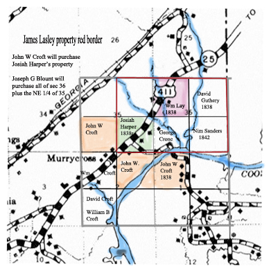
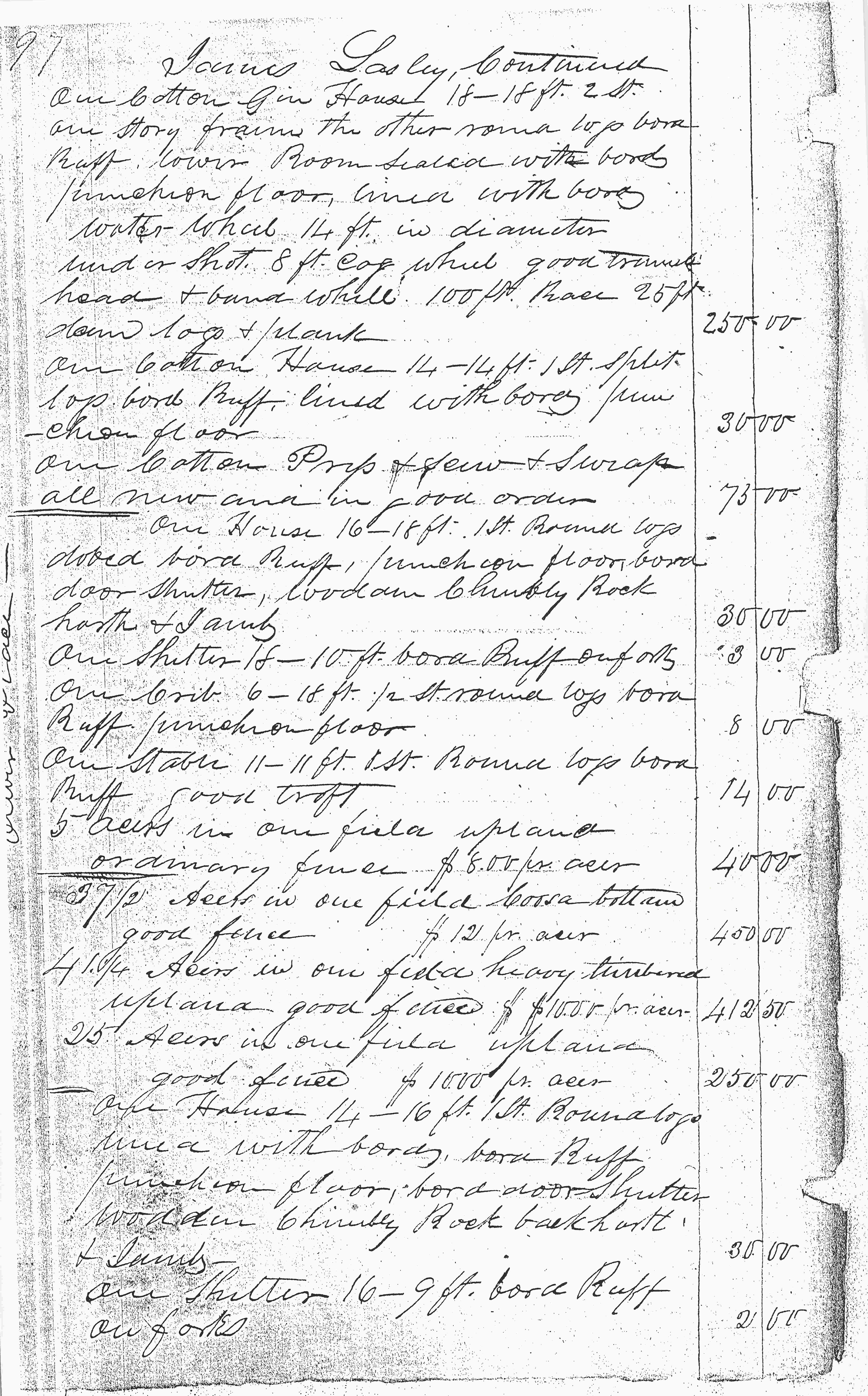
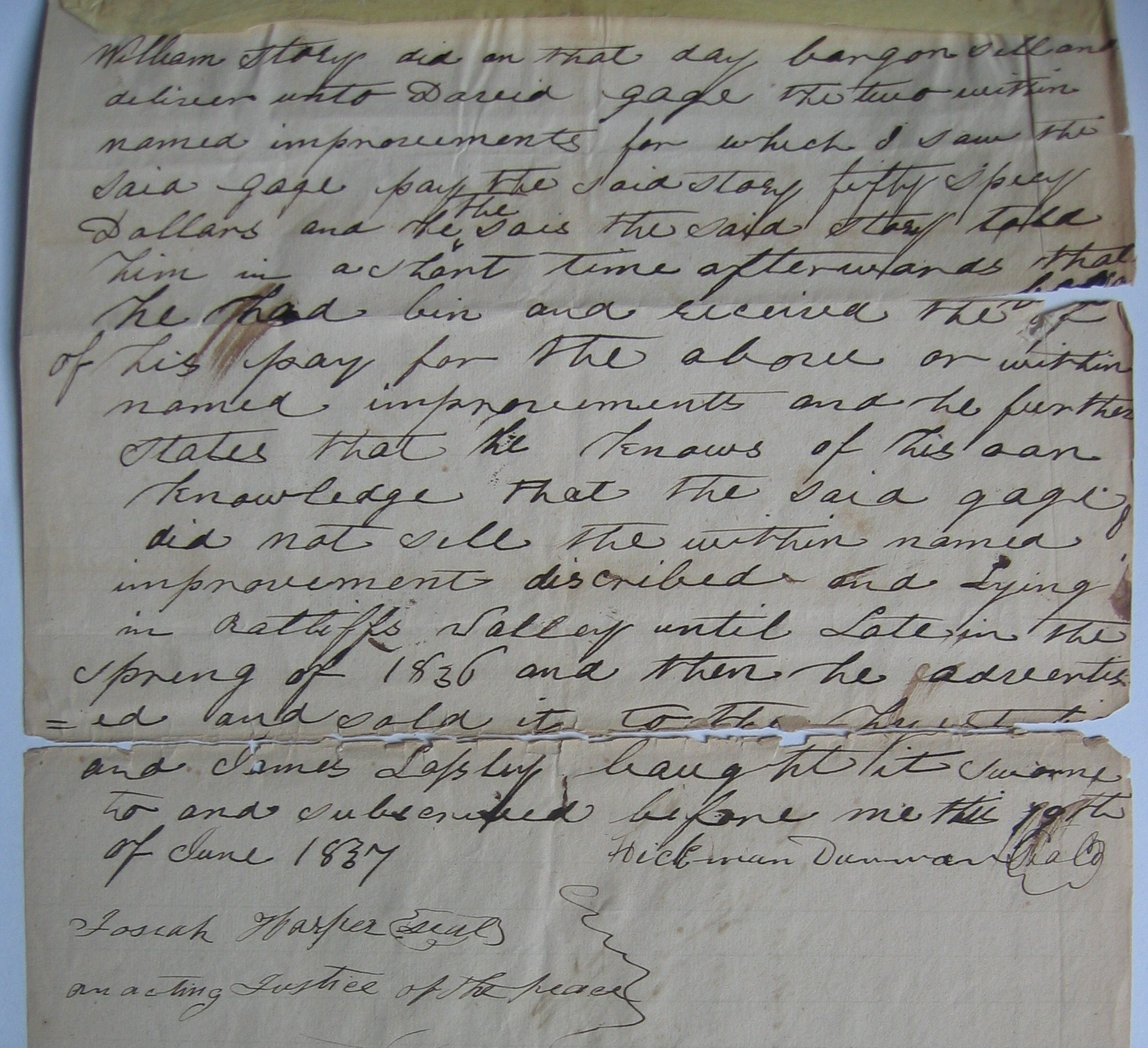
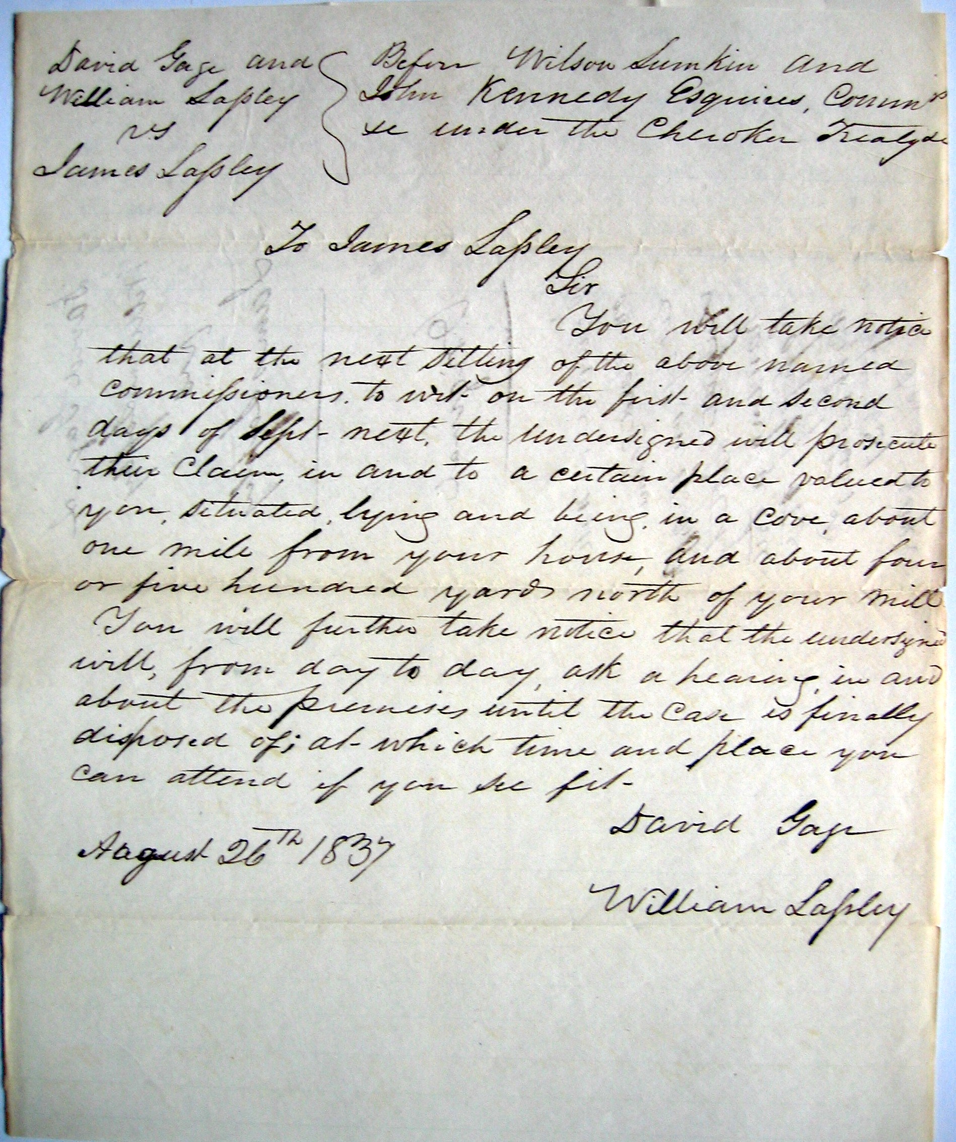
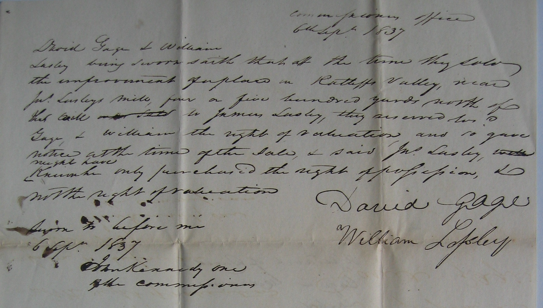
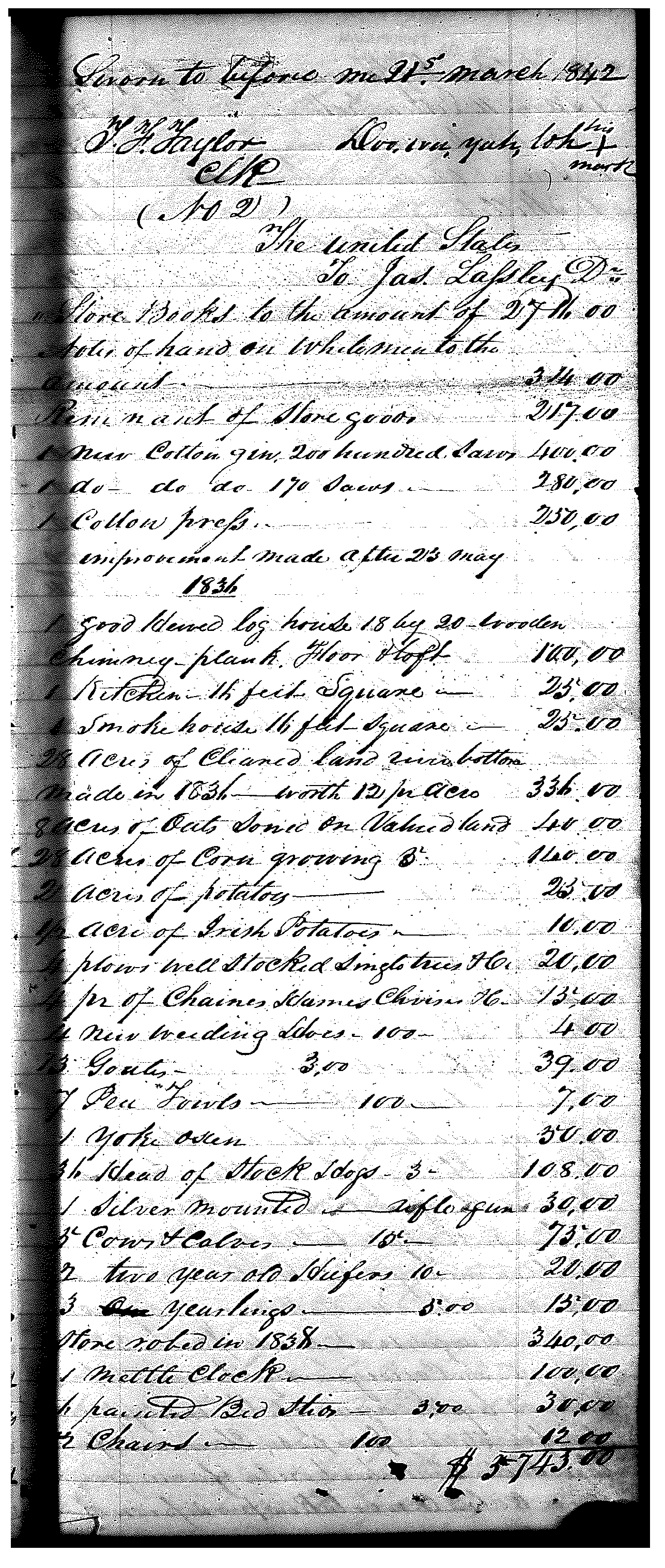
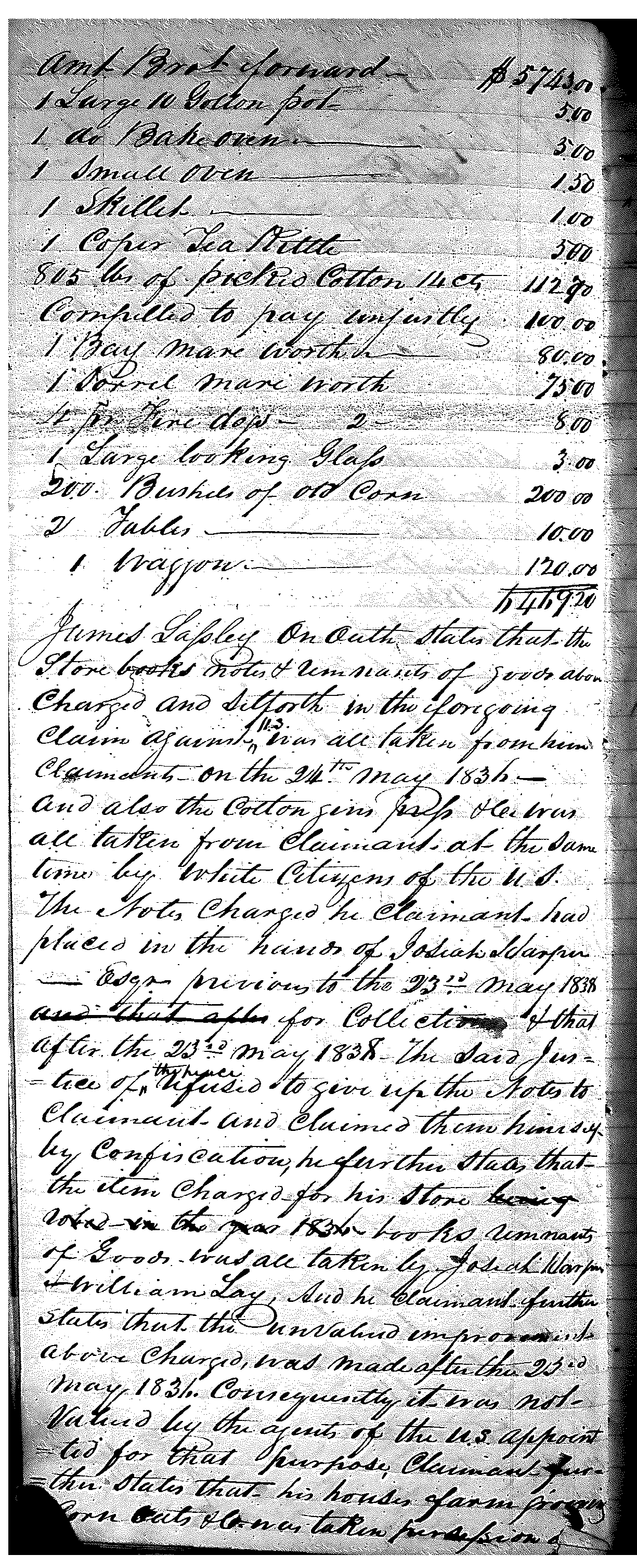
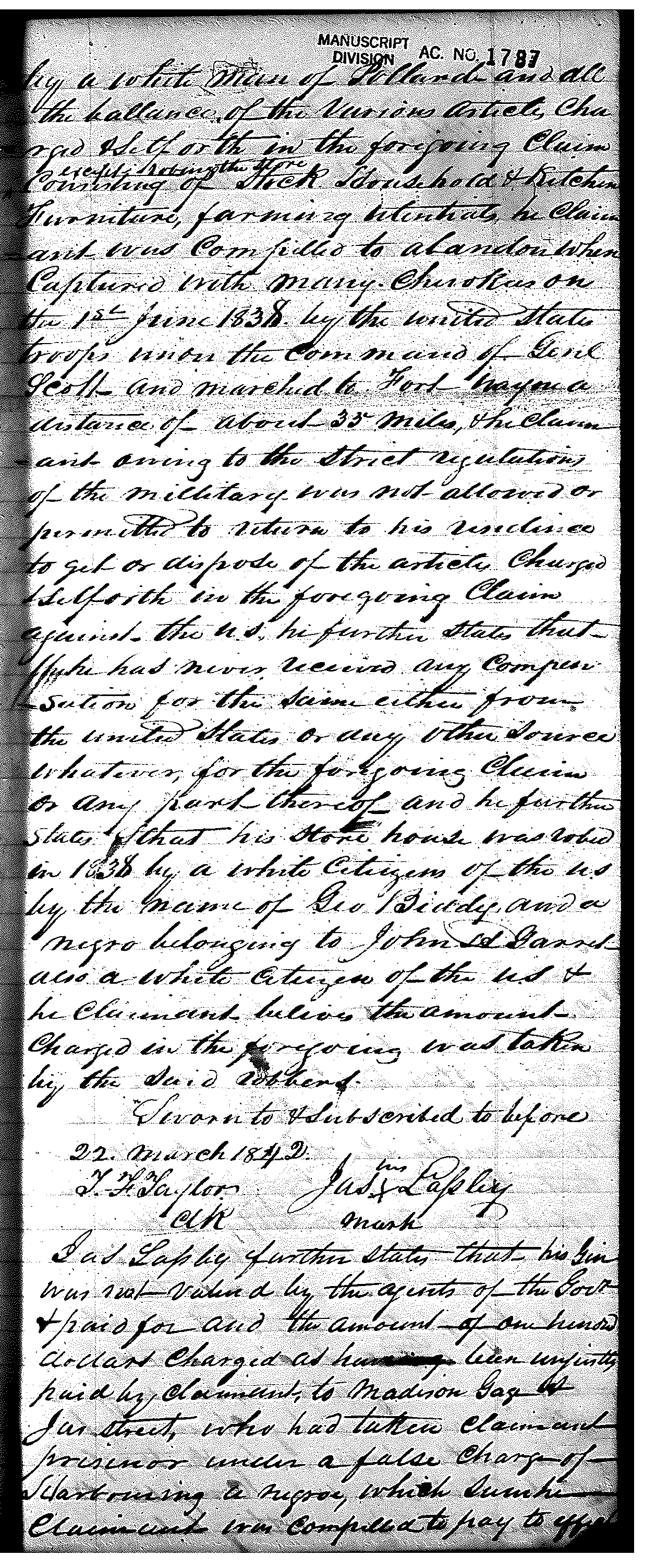
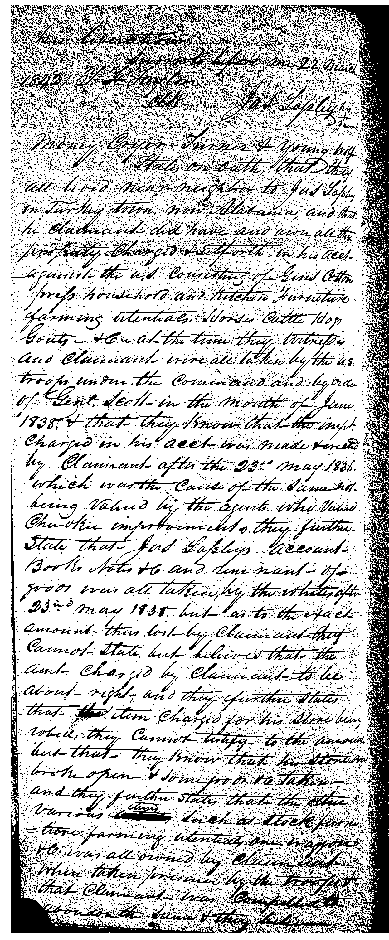
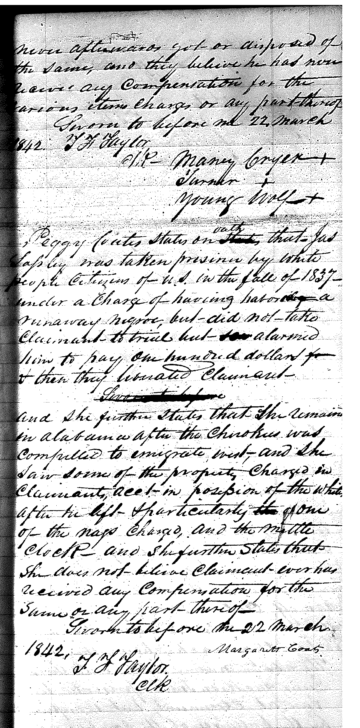
The names of William Lay and Josiah Harper should stand out on the above mapping of Lasley’s property. If you remember from last post on James Lasley. They were accused by James Lasley of stealing from him. See the following clip from James Lasley’s 1842 claim where he names these two white men.

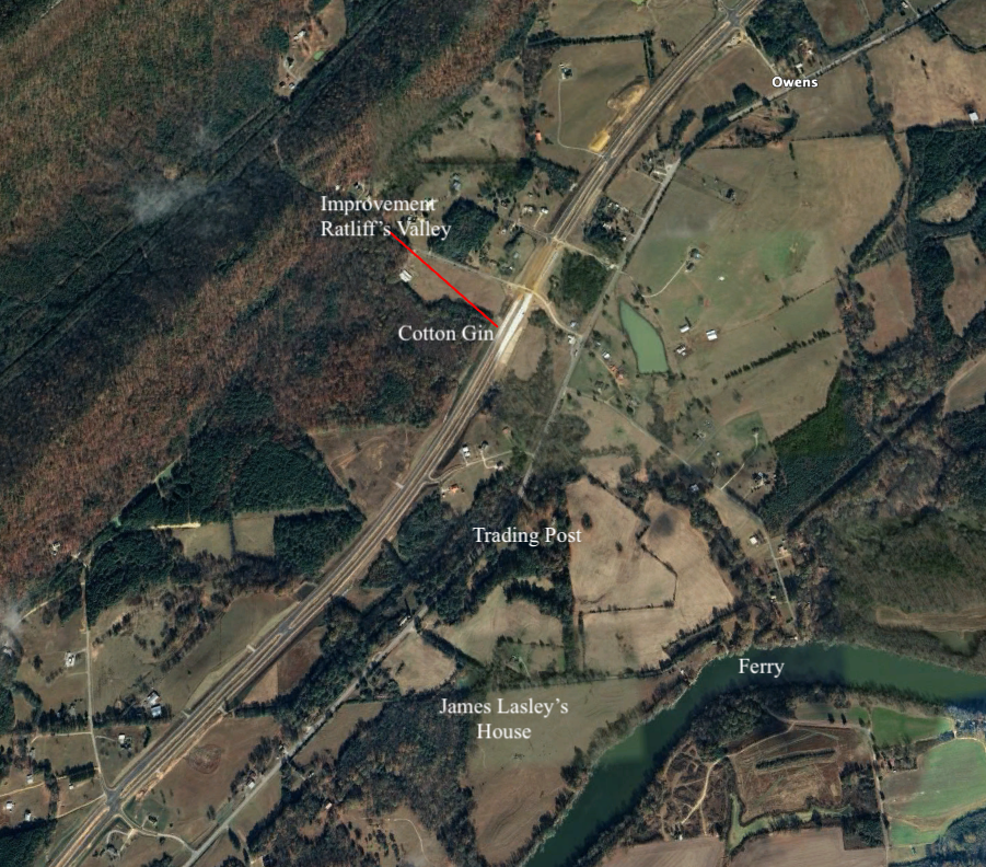
This confirms the location of James Lasley’s plantation. Josiah Harper was appointed Justice of the Peace in the newly formed Cherokee County Alabama, in 1836. (Alabama U. S. Civil Appointments 1819-1939, Ancestry.com) He, along with William Lay, homesteaded the property and filed for purchase through U. S. Patent Office in 1838.1 This is the present-day Croft Ferry area. John W. Croft, with preemption in 1838 purchased 159 acres on both sides of the Coosa River, which includes the ferry2. The original survey on the BLM website shows the road leading to this ferry. On the East side, it is labeled as Smith Ferry Road.
August 24, 1838, James Lasley filed a Claim where he states that; “he had a ferry across the Coosa River possibly taken by David Smith.3
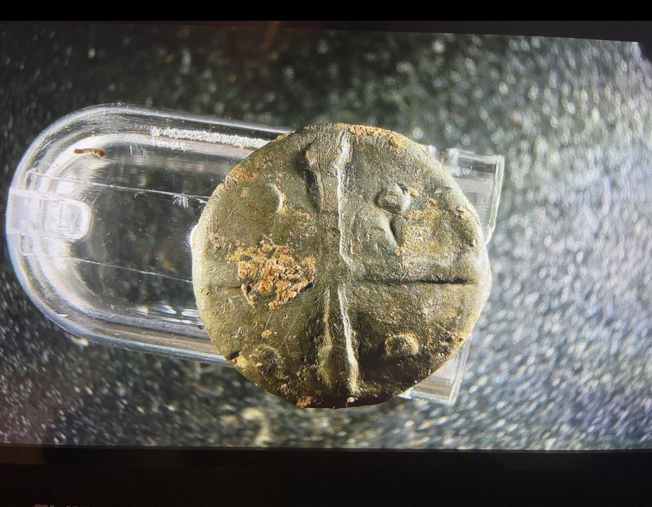
His house is located on the ferry road on the west side of the Coosa River. On the above map the ferry road travels straight then makes a left turn to travel to the river landing. The house was on the right side of the road at the left turn. This also falls within the one mile from the “cove” property discussed in the last post. Metal detectors found a Spanish button from the mid-1740s on the lot where the old homestead was located. James Lasley is the only known person to trade with the Spanish living on this property. He would have a garment from the time period.
James Lasley did not mention the Croft family or George Crone. They must be friends with James Lasley. They are mentioned on miscellaneous papers in good favor of James Lasley. William, David, and John W. Croft are brothers. Review the above map of property owners. Reminder you can click on the image to make it larger.
Other Confirmation
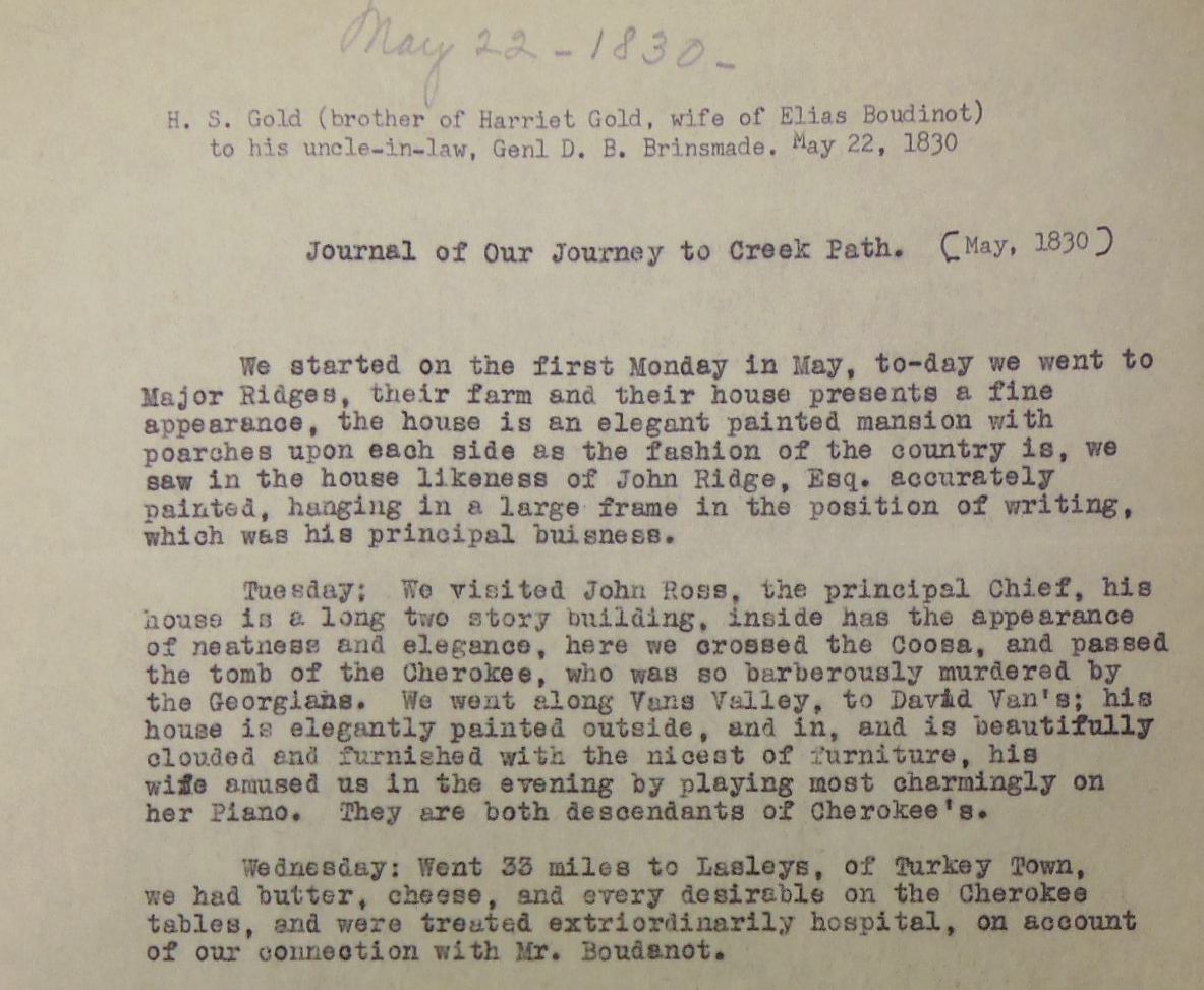
A letter by H. S. Gold to Gen. D. B. Brinsmade. He went to visit his sister in New Echota, but also traveled to Creek Path (Guntersville, AL). They traveled from Vann’s Valley which is Caves Springs, Georgia. This researcher has driven from Caves Springs to Croft Ferry on as much of the route that still exists. It is 35 miles. Elias Boudinot is Buck Watie, the Editor of the Cherokee Phoenix newspaper.
James Lasley is listed in the Henderson roll 1835 (Cherokee Census). On page 82 as in Turkey town in the transcribed copy;
“Six Cherokee, 1 fullblood, 2 halfbreeds, 2 quadroons (quarter blood Indian), 2 slaves, intermarraiage with white race. This family owned a mill and a ferryboat. One farmer, 2 farms, 1 reader of English, one weaver, 1 spinster.”5
As James Lasley stated in one of his Claims (previously posted), he was removed from his property in June 1838. James Lasley is listed in the Benge Detachment in the removal from Fort Payne, with 3 persons in the family. James and Elizabeth’s children also went West. Margaret, also known as Peggy, was married to Gideon Coats. She went with her children from Andrew Vann’s previous marriage. It is listed that she went by “her on account”, 3 persons in the family. William went “on his on accord”, seven in the family. Auley, who was married to Jack Griffin with four in the family was in the Bell Detachment.6
Blount Plantation
How did the name of this location come to be known as the Blount Plantation?
William Lay purchased 660 extra acres in 1848. Lasley accused him of stealing a portion of his property. This purchase brought Lay’s total to 887 acres. On 18 January 1854, he sold the property to brothers Joseph G. Blount and David E. Blount.7 24 May 1854 David Blount sold his share to Joseph. Joseph G. Blount moved to Alabama from Georgia ca. 1854. He would move back-in-forth from Alabama to Dekalb County, Georgia, and Gadsden, Alabama. Blount is on the 1860 US Census listed in First District, Cherokee County, Alabama, P.O. King’s Hill (present-day Slackland, Alabama). This would be on this homestead. The 1860 US Census lists Joseph G. Blount, 27 years old, Male, Farmer occupation. Value of real estate $16,000.00, personal property value $50,000.00. Wife Maria L. (Freeman), 23 years old, Female, Daughter; Anne T., 2 years old, Female. Living next door is Henry M. Cox whose occupation is “Overseer”,8 (He is the overseer for the plantation). Mr. Blount owned 45 slaves per the 1860 slave schedule in Cherokee County, Alabama. In 1870 he is listed as living in Gadsden City, P.O. Gadsden, 37 years old, Mechanic occupation, Wife Maria L, 32 years old, keeping house as occupation, son Joseph A., 3 years old (Gus). In 1880 Blount is living in DeKalb County, Georgia, on the census at District 531, Joseph G. Blount, 47 years old, Farmer occupation, wife Maria, 42 years old, keeping house occupation, son Augustus, 14 years old. Blount is on the 1900 Census in Turkeytown, Alabama. Joseph G Blount is 67 years old and has a Farmer occupation. His wife, Martha F., is 46 years old (Joseph lists this as his 2nd marriage since his first wife Maria, died Feb 1897). Son Joseph A., 33 years old, is a lawyer by occupation. Joseph Augustus (Gus) Blount married on 24 November 1900. This took place in New Orleans. He married Marie Lily Tremonlet (daughter of Henry Tremonlet).
John W. Croft lived just south of this plantation. On the Croft property in May of 1863, Colonel Abel Streight, US Army, and General N. B. Forrest (CSA, Cavalry) would come to a head-to-head fight. It is at this location that Colonel Gilbert of the 73rd Indiana US Regiment was killed. Four other Union soldiers also died. All of their bodies were exhumed. Hathaway taken to his home town in Indiana. The other Union soldiers taken to the Military Cemetery in Marietta, Georgia. In the Official Record of the War of Rebellion this location is called the “Blount Plantation”.9
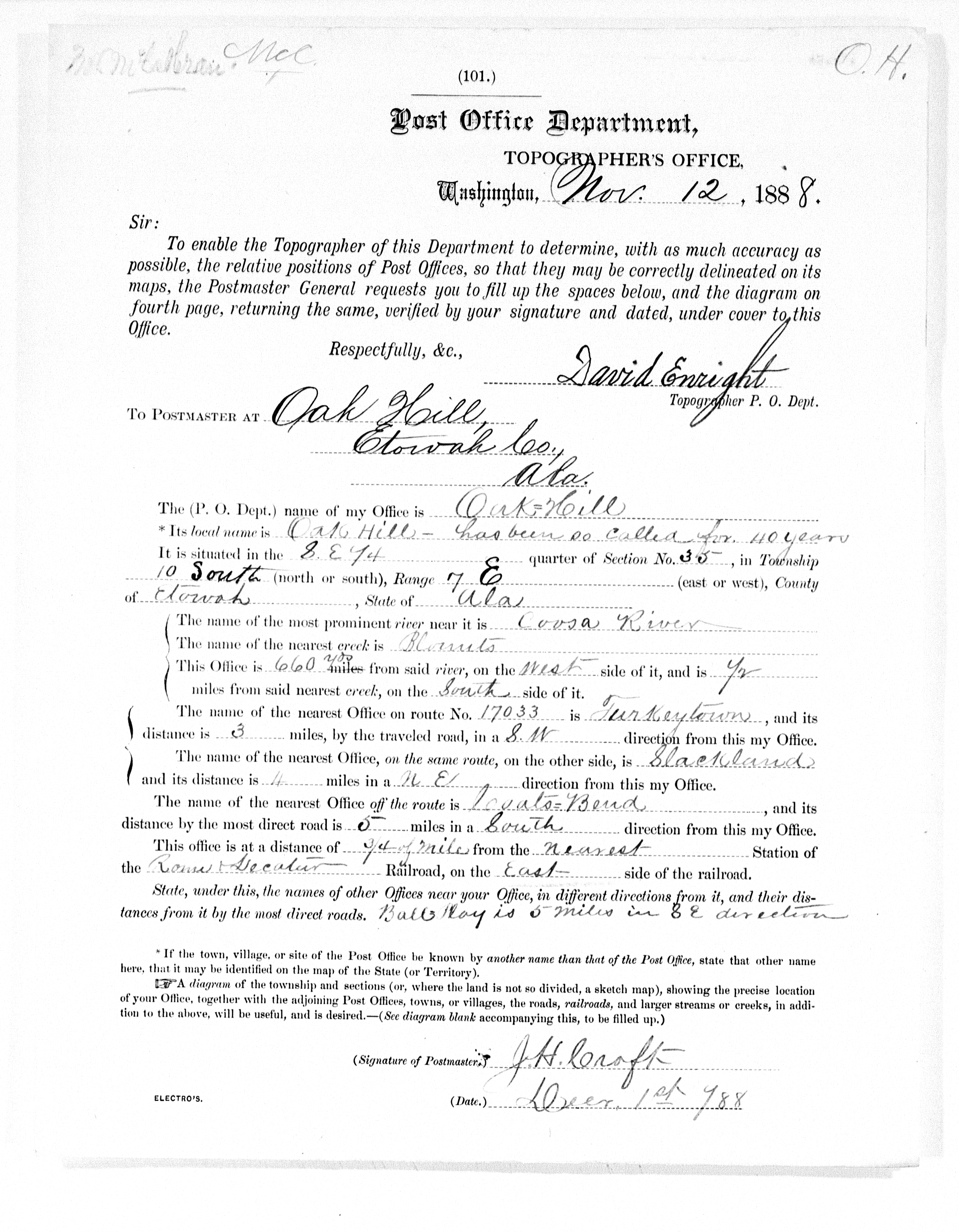
Oak Hill
Oak Hill Post Office. John W. Croft purchases the property North and South of the ferry. His two brothers will be a part of these purchases. In 1838, John W. Croft purchased 159 acres. This land was in NW ¼ of section 1 of Township 11 South, Range 7 East. This land is on both sides of the Coosa River and includes the ferry. See the map above. The original survey on the BLM website shows the road leading to this ferry on the East side. It is labeled as Smith Ferry Road. John W. Croft purchased 159 acres in section 2. It was the NE 1/4. This land is on the West side of Coosa River. He purchased Josiah Harper’s 159 acres in section 35 north of him. He also owned the SW ¼ of section 35, which brings John W. Croft’s total to right at 636 acres. His brothers William B. and David Croft purchased the NW ¼ and the SW ¼ of section 2.10 After the formation of Etowah County in 1868, a Post Office was established at Mr. John H. Croft’s home (son of John W. Croft) on May 24th, 1875. This post office was named after the farm Oak Hill because of the oak trees on the hill behind it.
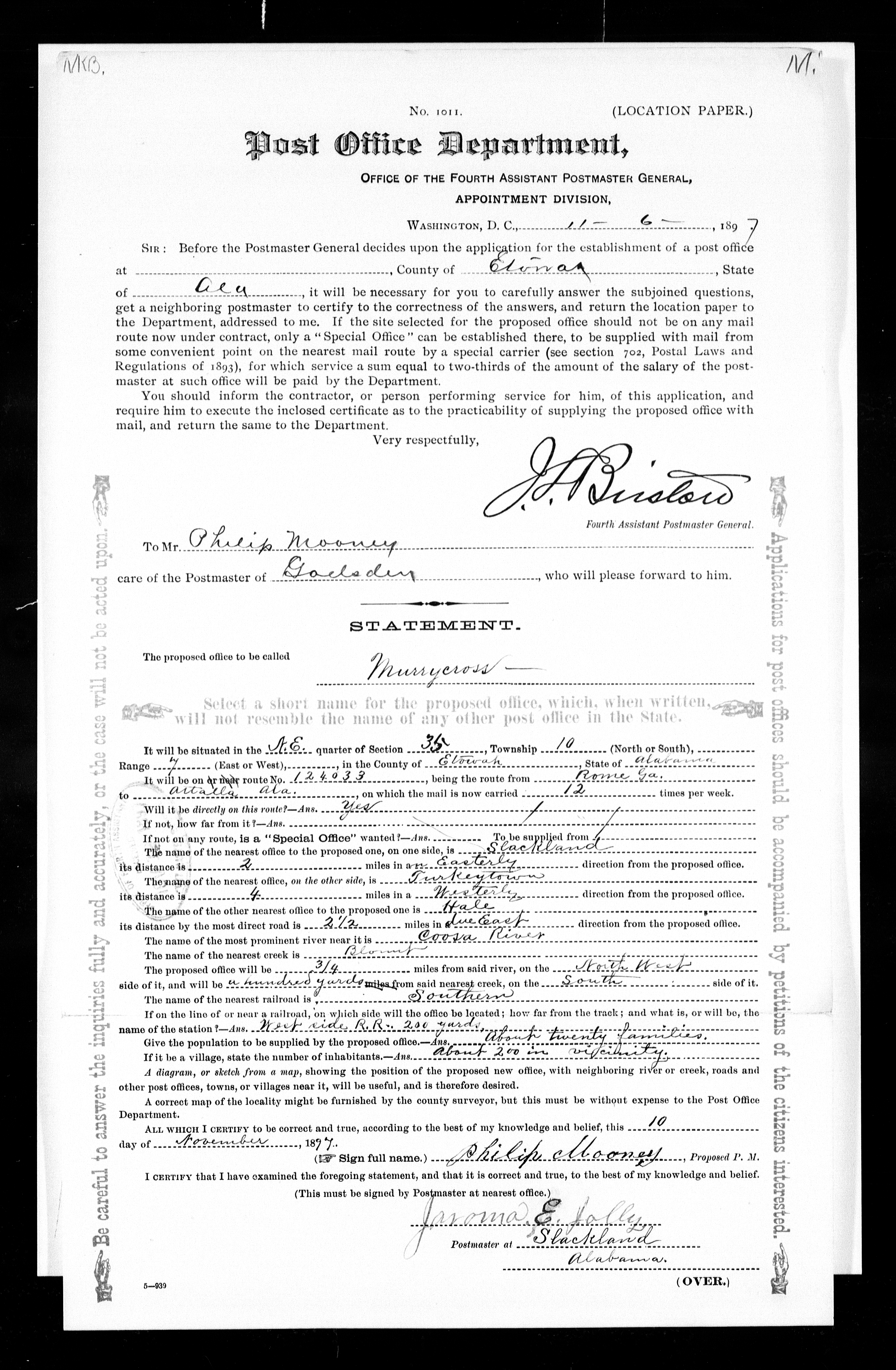
Murrycross.
Charles Philip Mooney is the Murrycross Post Office Postmaster, 1898. (United States Postal records found online at ancestry.com.) The name of Murrycross or Murry Cross came from Joseph Augustus (Gus) Blount, son of Joseph G. Blount. He named a new Post Office for his friend Father Daniel Murray of the Mobile Archdiocese. Father Murray served in the Birmingham Alabama Diocese.
In the history of St James’ Catholic Church of Gadsden 1957 titled; History of St. James Parish, by Flounce A. Burke. page one;
“Thirty years ago, on October 3, 1927 St. James Church was dedicated” . . . Will I Martin was the only person living who knew first hand of the early days of the Catholic Church in Gadsden, . . .
Joseph Augustus (Gus) Blount was educated at Kirkwood Military Institute in Atlanta, and Mt. St. Mary’s College, a Catholic institution at Emmitsburg, Md. He graduated in 1886. He took up the study of law with Judge James Aiken, of Gadsden, in 1888. He was admitted to the bar in 1890.
Continued from the history of St James Church;
They invited a Catholic priest, Father Murray from Mobile, to come to the district. He stayed in their home. A year later yellow fever broke out . . .and the story, “BEING A CATHOLIC PRIEST, FATHER MURRY VISITED ALL THE HOMES WHERE THERE WERE VICTIMS OF THE DREAD SCOURGE.” He contracted the disease and died, in 1903. Not long after the death of Father Murray, Gus Blount was given permission to select a name for the newly established post office. He wanted it named for the hero priest, Father Murray. The name was sent to Washington, and through a typographical error, the name was spelled “Murrycross”. It was impossible to have it changed, so until this day it is called Murrycross.” 11
Mr. Martin is incorrect about the timeline. Newspaper reports and the U. S. Postal Records confirm the story and correct the timeline. Rev. Father Daniel Murray, serving in Birmingham, served the Catholic Church in Gadsden during the year 1896.12 He died of yellow fever on 24 September 1897 in Mobile, Alabama. He had moved to Montgomery, Alabama, to be the assistant at St. Peter’s Church. He left the same position after three years and three months at St. Paul’s Church in Birmingham, Alabama. While on a temporary assignment in Mobile, he contracted yellow fever and died on 24 September 1897. He was serving the congregation at St. Vincent’s Church in Eufaula, Alabama.13
Murrycross and its Post Office were established on 10 November 1897. Oak Hill’s name changed. The Postmaster is Charles Philip Mooney Jr., “Philip”. The 1910 census of Etowah County lists Charles P. (Philip) Mooney Jr. living between Joseph G. Blount and James A. Penny (which would lead you to believe this is the old Oak Hill PO). James A. Penny becomes the Postmaster in 1905 of Murrycross PO. James A. Penny is married to John H. Croft’s widow (Mary E. Hughes Croft). Mary Elizabeth is the daughter of James A. Hughes Jr. and his wife Parolee Whorton. The Whortons and Hughes families are notable people in Turkey’s Town. Their stories to come later.

Conclusion
James Lasley is a notable person of Turkey’s Town. His plantation became multiple family farms after his forced removal. Today, the community is referred to as Murrycross/Croft Ferry. North of James Lasley is Richard Ratliff Sr. He, too, is a notable person of Turkey’s Town. His story has connections to General Andrew Jackson and David Crockett. This area, before James Lasley moved to it was called Ratliff’s Valley.
- From the Bureau of Land Management (BLM), General Land Records online website, the two white men filed pre-emption in 1838. Josiah Harper purchased, section 35, Township 10 S, Range 7 E; 159 acres, SW ¼. William Lay in section 36, Township 10 S, Range 7 E, the NW ¼ 159 acres. ↩︎
- From the Bureau of Land Management (BLM), General Land Records online website, NW ¼ of section 1 of Township 11 S, Range 7 E, this is ↩︎
- ” Indian Pioneer Papers, University of Oklahoma, Western History Collection, Norman Ok, Volume 105, Grant Forman Interview #1425. Registration of Claims of Cherokee Indians against the U. S., within the State of Alabama. Claim #19. The original Claim Book is in Oklahoma Historical Society Microfilm CHN80 in Section X (Cherokee-Federal Relations). Page 246, Ferries, Coosa River #7 Township 11 South, Rang 7 East, Section unknown (probably 1 and 2)” Lasley Ferry/ Smith’s Ferry/ Croft’s Ferry by Mike Wren recorded in “Alabama Collection Camps, Forts, Emigrating Depots and Travel Routes Used During the Cherokee Removal of 1838-1839” ↩︎
- Spanish button found on the property in 2023 by relic hunters. Other period items were found on the property. Interview by the author ↩︎
- https://www.okhistory.org/research/digital/foremantrans/foreman.sup14.pdf Henderson Roll Vol 14, page 82, Oklahoma Historical Society ↩︎
- RG 217, records of the Accounting Officers of the Department of the Treasury, E 525, settled Indian Accounts and Claims, 1794-1894, Box 379, Account 6432, National Archives, copies from the Michael Wren collection. ↩︎
- Bureau of Land Management (BLM), General Land Records online website. ↩︎
- 1860 US Census listed in First District Cherokee County Alabama P.O. King’s Hill ↩︎
- Etowah County Historic Plat records online https://etowahcounty.org/historic-plats/, Bureau of Land Management (BLM), General Land Records online website. ↩︎
- Personal copy of the History of the Saint James Catholic Church, Gadsden, Alabama. ↩︎
- The Montgomery Advertiser, Montgomery, Alabama, 15 March 1896, Sunday, Page 3, December 1896, Page 3, The Birmingham News, Birmingham, Alabama 19 January 1897, Tuesday, page 1, Newspaper.com ↩︎
- Birmingham News, Birmingham, Alabama, 19 January 1897, Tuesday, page 1, Newspaper.com, The Eufaula Daily Times, Eufaula, Alabama, 24 September 1897, Friday, Page 4 and The Herald-Journal, Bessemer, Alabama, 30 September 1897, Thursday, Page 4, Newspaper.com ↩︎
Trust in the Lord with all your heart, and do not rely on your own understanding; in all your ways know him, and he will make your paths straight. Proverbs 3: 5-6 CSV